Region VII - Negros Oriental
•Download as DOCX, PDF•
0 likes•939 views

handouts for negros oriental

Recommended
More Related Content
What's hot
What's hot (20)
Viewers also liked
Viewers also liked (20)
More from Bren Dale
More from Bren Dale (20)
Recently uploaded
Recently uploaded (20)
Region VII - Negros Oriental
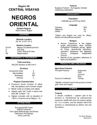
- 1. Region VII CENTRAL VISAYAS NEGROS ORIENTAL Eastern Negros Native Name: Buglas LOCATION Absolute Location 09° 45´ N 123° 00´ E Relative Location N & W Negros Occidental province S Sulu Sea E Tañon Strait and Cebu SE Negros Island GEOGRAPHY & TOPOGRAPHY Total Land Area 540,230 hectares (5,402.3 km²) Divisions Component Cities 6 Municipalities 20 Barangays 557 Districts 3 Physical Characteristics ● Province’s terrain consists of rolling hills, few plateaus and mountain ranges ● Mostly made up of plains and valleys ● Highest peak with 2,450 m above sea level (Mt. Canlaon – N) ● Highest mountain with an elevation of 1,903 m (Cuernos de los Negros – S) ATTRACTIONS Dumaguete Bell Tower Silliman University Twin Lakes Balinsasayao and Danao Palimpinon Hot Springs Camp Look Out Festival Buglasan Festival – Dumaguete, October (week-long celebration) DEMOGRAPHY Population 1,286,666 (as of 2010 by NSO) Language Cebuano 94% Hiligaynon 5% Others 1% *Filipino and English are used for official, literary and educational purposes. Religion ● Roman Catholicism is the biggest single denomination, other includes Evangelical Protestant groups, Iglesia Ni Cristo, Seventh-day Adventists, Jehovah’s Witnesses and Aglipayan Church (Philippine Independent Church) ● Minority of the population adherents of Islam and Buddhism PRODUCTS AND LIVELIHOOD Agricultural Industry Principal Products: Sugarcane Corn Coconut Rice Source of Livelihood: Fishing *Metallic minerals found in the province include gold, silver and copper. CLIMATE Tropical 2 climatic conditions – eastern part of the province is characterized by unpronounced maximum rainfall with short dry season lasting for 1 to 3 months, and the western half of the province is characterized by distinct wet and dry season. Lea Marie Mandane BEEd III-14