SlideShare a Scribd company logo
1 of 1
Download to read offline
Literature
Brown, G., Kyttä, M., 2014.
Key issues and research
priorities for public
participation GIS (PPGIS): A
synthesis based on empirical
research. Appl. Geogr. 46,
122–136.
Eräranta, S., Kahila-Tani, M.,
Nummi-Sund, P., 2015. Web-
based public participation in
urban planning
competitions. Int. J. E-Plan.
Res. IJEPR 4.
Rantanen, H., Kahila, M.,
2009. The SoftGIS approach
to local knowledge. J.
Environ. Manage.,
Collaborative GIS for spatial
decision support and
visualization 90, 1981–1990.
Acknowledgments
Special thanks to Berit Balfors (KTH) and
Gustav Malm (White Arkitekter); the teams at
Mapita and Projektet Medborgardialog,
Spacescape, and all other interviewees.
Further information:
ibabelon@kth.se
Some softGIS suppliers:
• Mapita, Finland
• Spacescape, Sweden
• Projektet Medborgardialog at SKL,
Sweden
• Commonplace, UK
Methodology
Case-studies: 3 SoftGIS tools used in
Finnish and Swedish municipal
planning
• Interviews: planners and softGIS
developers
• Literature review: scientific and
land-use policy literature
• Participant observation:
professional seminars on theme of
digital public engagement
Question: How can softGIS support
collaborative planning?
Conclusions
• SoftGIS is meant to be combined
with other methods, both digital
and physical
• Be clear about the context and
purpose of participation:
Why, who to involve, how, and for
whom?
• Continuous follow-up is vital,
especially about how survey
inputs serve planning
• Helps to build trust and dialogue
• It can be difficult to stimulate
citizen interest in planning
• Does not fit all kinds of spatial
cognition/ people
• Long-term education about spatial
thinking can improve collaborative
planning
SoftGIS in a nutshell:
• A Public Participation Geographic
Information system (PPGIS) for
land-use planning, typically in
early comprehensive planning
• Mapping surveys: interactive Bing
or Google maps with customized
questionnaires, drag-and-drop
markers, and pop-up text boxes to
comment locations
• Used for mapping “place values” –
values/views (environmental,
cultural, social) which lay residents
have about places
• “Soft” = residents’ knowledge and
views about places. Complements
quantitative and other “hard”
expert GIS data
• Data results are queriable and
compatible with professional GIS
Opportunities & Challenges
SoftGIS: web-based mapping surveys for
collaborative Impact Assessment
Ian Babelon
EMA Group, Land & Water Resources Engineering, KTH,
Teknikringen 76, 100 44 Stockholm, Sweden
SoftGIS can be used to:
• Assess impacts – EIA, SEA, SIA
• Collect baseline data: e.g. survey
ecosystem services
• Identify attractive development
locations, including alternatives
• Localise compensation
• Follow-up
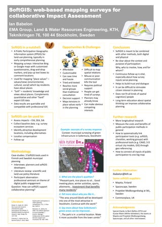
Example: excerpts of a survey response
Context: municipal surveying of green
infrastructure in Sollentuna, Stockholm
1. What are the place’s qualities?
”Pleasant park, nice places to sit… Good
meeting place, winter activities, sports,
allotments… Investment that benefits
many residents”
2. Tell more about why you like it…
”The area around Edsvik will be developed
into one of the most attractive in
Stockholm. Continue with the work!”
3. Say more about how Sollentuna’s
green areas can be improved…
”…The park is in a central location. Make
it more accessible from the town center.”
• Affordable
• Customisable
• Can save time
and hassle
• Tried-and-tested
• Reaches more
social groups
than traditional
consultation
• Decision support
• Maps tensions in
place values early
in the planning
• Difficult to map
spatial relations
• Misuse or poor
communication
kills the tool
• Requires political
support
• People can get
tired of surveys
• Planners may
already know
• Can make obvious
competing
interests
Further research
• More longitudinal research
• Measure the costs and benefits of
public participation methods in
general
• How to systematically link
participation tools (e.g. softGIS,
charettes, working groups) with
professional tools (e.g. CAAD, 3-D
virtual city models, GIS) through
geo-referencing
• How to connect all inputs of public
participation to one big map

More Related Content

Viewers also liked

softGIS innovation diffusion
softGIS innovation diffusionsoftGIS innovation diffusion
softGIS innovation diffusionKristoffer Snabb
 
An Assessment of Online PPGIS Case Studies in Urban Planning Geisa Bugs - Fe...
An Assessment of Online PPGIS Case Studies in Urban Planning Geisa Bugs  - Fe...An Assessment of Online PPGIS Case Studies in Urban Planning Geisa Bugs  - Fe...
An Assessment of Online PPGIS Case Studies in Urban Planning Geisa Bugs - Fe...Beniamino Murgante
 
Living+ platform in Aalto University
Living+ platform in Aalto UniversityLiving+ platform in Aalto University
Living+ platform in Aalto UniversityAalto_Living
 
Politics and Urban Planning Process
Politics and Urban Planning ProcessPolitics and Urban Planning Process
Politics and Urban Planning ProcessASRufai
 
Movement for Liveable London Street Talks - Tim Gill 7th February 2012
Movement for Liveable London Street Talks - Tim Gill 7th February 2012Movement for Liveable London Street Talks - Tim Gill 7th February 2012
Movement for Liveable London Street Talks - Tim Gill 7th February 2012Movement for Liveable London
 

Viewers also liked (8)

softGIS innovation diffusion
softGIS innovation diffusionsoftGIS innovation diffusion
softGIS innovation diffusion
 
softGIS api
softGIS apisoftGIS api
softGIS api
 
An Assessment of Online PPGIS Case Studies in Urban Planning Geisa Bugs - Fe...
An Assessment of Online PPGIS Case Studies in Urban Planning Geisa Bugs  - Fe...An Assessment of Online PPGIS Case Studies in Urban Planning Geisa Bugs  - Fe...
An Assessment of Online PPGIS Case Studies in Urban Planning Geisa Bugs - Fe...
 
Geolocation
GeolocationGeolocation
Geolocation
 
RRGAAS.1
RRGAAS.1RRGAAS.1
RRGAAS.1
 
Living+ platform in Aalto University
Living+ platform in Aalto UniversityLiving+ platform in Aalto University
Living+ platform in Aalto University
 
Politics and Urban Planning Process
Politics and Urban Planning ProcessPolitics and Urban Planning Process
Politics and Urban Planning Process
 
Movement for Liveable London Street Talks - Tim Gill 7th February 2012
Movement for Liveable London Street Talks - Tim Gill 7th February 2012Movement for Liveable London Street Talks - Tim Gill 7th February 2012
Movement for Liveable London Street Talks - Tim Gill 7th February 2012
 

Similar to SoftGIS for colloborative Impact Assessment

New Map Librarians: Local Perspectives and Local Experiences on Digital Spati...
New Map Librarians: Local Perspectives and Local Experiences on Digital Spati...New Map Librarians: Local Perspectives and Local Experiences on Digital Spati...
New Map Librarians: Local Perspectives and Local Experiences on Digital Spati...Rose Holley
 
Expo 2010 - Presentation map table
Expo 2010 - Presentation map tableExpo 2010 - Presentation map table
Expo 2010 - Presentation map tablegrenzeloosduurzaam
 
Modeling of future transport systems from different point of views: data, tec...
Modeling of future transport systems from different point of views: data, tec...Modeling of future transport systems from different point of views: data, tec...
Modeling of future transport systems from different point of views: data, tec...Sonia Yeh
 
Towards 'Resilient Cities' - Harmonisation of Spatial Planning Information as...
Towards 'Resilient Cities' - Harmonisation of Spatial Planning Information as...Towards 'Resilient Cities' - Harmonisation of Spatial Planning Information as...
Towards 'Resilient Cities' - Harmonisation of Spatial Planning Information as...Beniamino Murgante
 
School on the Cloud: lessons from Digital Earth, Karl Donert
School on the Cloud: lessons from Digital Earth, Karl DonertSchool on the Cloud: lessons from Digital Earth, Karl Donert
School on the Cloud: lessons from Digital Earth, Karl DonertBrussels, Belgium
 
Living+ kickoff slideset
Living+ kickoff slidesetLiving+ kickoff slideset
Living+ kickoff slidesetMikko Särelä
 
U spatial digital-humanities
U spatial digital-humanitiesU spatial digital-humanities
U spatial digital-humanitiesfhap13
 
Danish groundwater mapping – geological information building and disseminatio...
Danish groundwater mapping – geological information building and disseminatio...Danish groundwater mapping – geological information building and disseminatio...
Danish groundwater mapping – geological information building and disseminatio...Geological Survey of Sweden
 
Portfolio_Juvair Hossan_KU_BD.pdf
Portfolio_Juvair Hossan_KU_BD.pdfPortfolio_Juvair Hossan_KU_BD.pdf
Portfolio_Juvair Hossan_KU_BD.pdfJuvairHossan1
 
Plannning Parks for Liveable Cities: Green Technology Design Practice for Tas...
Plannning Parks for Liveable Cities: Green Technology Design Practice for Tas...Plannning Parks for Liveable Cities: Green Technology Design Practice for Tas...
Plannning Parks for Liveable Cities: Green Technology Design Practice for Tas...Rijal Saffuan
 
02 -how-will-inspire-influence-local-authorities-and-spatial-planning
02 -how-will-inspire-influence-local-authorities-and-spatial-planning02 -how-will-inspire-influence-local-authorities-and-spatial-planning
02 -how-will-inspire-influence-local-authorities-and-spatial-planningKarel Charvat
 
GI Learner: A project to develop geospatial thinking learning lines in second...
GI Learner: A project to develop geospatial thinking learning lines in second...GI Learner: A project to develop geospatial thinking learning lines in second...
GI Learner: A project to develop geospatial thinking learning lines in second...Karl Donert
 
National Cheng Kung University
National Cheng Kung University National Cheng Kung University
National Cheng Kung University spikol
 
Extreme Citizen Science: the socio-political potential of citizen science
Extreme Citizen Science: the socio-political potential of citizen scienceExtreme Citizen Science: the socio-political potential of citizen science
Extreme Citizen Science: the socio-political potential of citizen scienceMuki Haklay
 
Dublin dashboard launch
Dublin dashboard launchDublin dashboard launch
Dublin dashboard launchrobkitchin
 

Similar to SoftGIS for colloborative Impact Assessment (20)

New Map Librarians: Local Perspectives and Local Experiences on Digital Spati...
New Map Librarians: Local Perspectives and Local Experiences on Digital Spati...New Map Librarians: Local Perspectives and Local Experiences on Digital Spati...
New Map Librarians: Local Perspectives and Local Experiences on Digital Spati...
 
Expo 2010 - Presentation map table
Expo 2010 - Presentation map tableExpo 2010 - Presentation map table
Expo 2010 - Presentation map table
 
Modeling of future transport systems from different point of views: data, tec...
Modeling of future transport systems from different point of views: data, tec...Modeling of future transport systems from different point of views: data, tec...
Modeling of future transport systems from different point of views: data, tec...
 
Towards 'Resilient Cities' - Harmonisation of Spatial Planning Information as...
Towards 'Resilient Cities' - Harmonisation of Spatial Planning Information as...Towards 'Resilient Cities' - Harmonisation of Spatial Planning Information as...
Towards 'Resilient Cities' - Harmonisation of Spatial Planning Information as...
 
Towards 'Resilient Cities' - Harmonisation of Spatial Planning Information as...
Towards 'Resilient Cities' - Harmonisation of Spatial Planning Information as...Towards 'Resilient Cities' - Harmonisation of Spatial Planning Information as...
Towards 'Resilient Cities' - Harmonisation of Spatial Planning Information as...
 
Aleksander Gumos - CV
Aleksander Gumos - CVAleksander Gumos - CV
Aleksander Gumos - CV
 
School on the Cloud: lessons from Digital Earth, Karl Donert
School on the Cloud: lessons from Digital Earth, Karl DonertSchool on the Cloud: lessons from Digital Earth, Karl Donert
School on the Cloud: lessons from Digital Earth, Karl Donert
 
ICT project idea: the Danube Data Cube
ICT project idea: the Danube Data Cube ICT project idea: the Danube Data Cube
ICT project idea: the Danube Data Cube
 
Living+ kickoff slideset
Living+ kickoff slidesetLiving+ kickoff slideset
Living+ kickoff slideset
 
U spatial digital-humanities
U spatial digital-humanitiesU spatial digital-humanities
U spatial digital-humanities
 
What is Crowdsourcing - Nicola Osborne
What is Crowdsourcing - Nicola OsborneWhat is Crowdsourcing - Nicola Osborne
What is Crowdsourcing - Nicola Osborne
 
Danish groundwater mapping – geological information building and disseminatio...
Danish groundwater mapping – geological information building and disseminatio...Danish groundwater mapping – geological information building and disseminatio...
Danish groundwater mapping – geological information building and disseminatio...
 
Portfolio_Juvair Hossan_KU_BD.pdf
Portfolio_Juvair Hossan_KU_BD.pdfPortfolio_Juvair Hossan_KU_BD.pdf
Portfolio_Juvair Hossan_KU_BD.pdf
 
Plannning Parks for Liveable Cities: Green Technology Design Practice for Tas...
Plannning Parks for Liveable Cities: Green Technology Design Practice for Tas...Plannning Parks for Liveable Cities: Green Technology Design Practice for Tas...
Plannning Parks for Liveable Cities: Green Technology Design Practice for Tas...
 
02 -how-will-inspire-influence-local-authorities-and-spatial-planning
02 -how-will-inspire-influence-local-authorities-and-spatial-planning02 -how-will-inspire-influence-local-authorities-and-spatial-planning
02 -how-will-inspire-influence-local-authorities-and-spatial-planning
 
GI Learner: A project to develop geospatial thinking learning lines in second...
GI Learner: A project to develop geospatial thinking learning lines in second...GI Learner: A project to develop geospatial thinking learning lines in second...
GI Learner: A project to develop geospatial thinking learning lines in second...
 
National Cheng Kung University
National Cheng Kung University National Cheng Kung University
National Cheng Kung University
 
Extreme Citizen Science: the socio-political potential of citizen science
Extreme Citizen Science: the socio-political potential of citizen scienceExtreme Citizen Science: the socio-political potential of citizen science
Extreme Citizen Science: the socio-political potential of citizen science
 
Big Data from Space
Big Data from SpaceBig Data from Space
Big Data from Space
 
Dublin dashboard launch
Dublin dashboard launchDublin dashboard launch
Dublin dashboard launch
 

Recently uploaded

RESPIRATORY ADAPTATIONS TO HYPOXIA IN HUMNAS.pptx
RESPIRATORY ADAPTATIONS TO HYPOXIA IN HUMNAS.pptxRESPIRATORY ADAPTATIONS TO HYPOXIA IN HUMNAS.pptx
RESPIRATORY ADAPTATIONS TO HYPOXIA IN HUMNAS.pptxFarihaAbdulRasheed
 
OECD bibliometric indicators: Selected highlights, April 2024
OECD bibliometric indicators: Selected highlights, April 2024OECD bibliometric indicators: Selected highlights, April 2024
OECD bibliometric indicators: Selected highlights, April 2024innovationoecd
 
The dark energy paradox leads to a new structure of spacetime.pptx
The dark energy paradox leads to a new structure of spacetime.pptxThe dark energy paradox leads to a new structure of spacetime.pptx
The dark energy paradox leads to a new structure of spacetime.pptxEran Akiva Sinbar
 
Harmful and Useful Microorganisms Presentation
Harmful and Useful Microorganisms PresentationHarmful and Useful Microorganisms Presentation
Harmful and Useful Microorganisms Presentationtahreemzahra82
 
Transposable elements in prokaryotes.ppt
Transposable elements in prokaryotes.pptTransposable elements in prokaryotes.ppt
Transposable elements in prokaryotes.pptArshadWarsi13
 
REVISTA DE BIOLOGIA E CIÊNCIAS DA TERRA ISSN 1519-5228 - Artigo_Bioterra_V24_...
REVISTA DE BIOLOGIA E CIÊNCIAS DA TERRA ISSN 1519-5228 - Artigo_Bioterra_V24_...REVISTA DE BIOLOGIA E CIÊNCIAS DA TERRA ISSN 1519-5228 - Artigo_Bioterra_V24_...
REVISTA DE BIOLOGIA E CIÊNCIAS DA TERRA ISSN 1519-5228 - Artigo_Bioterra_V24_...Universidade Federal de Sergipe - UFS
 
Call Girls in Majnu Ka Tilla Delhi 🔝9711014705🔝 Genuine
Call Girls in Majnu Ka Tilla Delhi 🔝9711014705🔝 GenuineCall Girls in Majnu Ka Tilla Delhi 🔝9711014705🔝 Genuine
Call Girls in Majnu Ka Tilla Delhi 🔝9711014705🔝 Genuinethapagita
 
Dubai Calls Girl Lisa O525547819 Lexi Call Girls In Dubai
Dubai Calls Girl Lisa O525547819 Lexi Call Girls In DubaiDubai Calls Girl Lisa O525547819 Lexi Call Girls In Dubai
Dubai Calls Girl Lisa O525547819 Lexi Call Girls In Dubaikojalkojal131
 
Neurodevelopmental disorders according to the dsm 5 tr
Neurodevelopmental disorders according to the dsm 5 trNeurodevelopmental disorders according to the dsm 5 tr
Neurodevelopmental disorders according to the dsm 5 trssuser06f238
 
Call Girls in Munirka Delhi 💯Call Us 🔝8264348440🔝
Call Girls in Munirka Delhi 💯Call Us 🔝8264348440🔝Call Girls in Munirka Delhi 💯Call Us 🔝8264348440🔝
Call Girls in Munirka Delhi 💯Call Us 🔝8264348440🔝soniya singh
 
LIGHT-PHENOMENA-BY-CABUALDIONALDOPANOGANCADIENTE-CONDEZA (1).pptx
LIGHT-PHENOMENA-BY-CABUALDIONALDOPANOGANCADIENTE-CONDEZA (1).pptxLIGHT-PHENOMENA-BY-CABUALDIONALDOPANOGANCADIENTE-CONDEZA (1).pptx
LIGHT-PHENOMENA-BY-CABUALDIONALDOPANOGANCADIENTE-CONDEZA (1).pptxmalonesandreagweneth
 
Citronella presentation SlideShare mani upadhyay
Citronella presentation SlideShare mani upadhyayCitronella presentation SlideShare mani upadhyay
Citronella presentation SlideShare mani upadhyayupadhyaymani499
 
Microphone- characteristics,carbon microphone, dynamic microphone.pptx
Microphone- characteristics,carbon microphone, dynamic microphone.pptxMicrophone- characteristics,carbon microphone, dynamic microphone.pptx
Microphone- characteristics,carbon microphone, dynamic microphone.pptxpriyankatabhane
 
Speech, hearing, noise, intelligibility.pptx
Speech, hearing, noise, intelligibility.pptxSpeech, hearing, noise, intelligibility.pptx
Speech, hearing, noise, intelligibility.pptxpriyankatabhane
 
User Guide: Orion™ Weather Station (Columbia Weather Systems)
User Guide: Orion™ Weather Station (Columbia Weather Systems)User Guide: Orion™ Weather Station (Columbia Weather Systems)
User Guide: Orion™ Weather Station (Columbia Weather Systems)Columbia Weather Systems
 
Four Spheres of the Earth Presentation.ppt
Four Spheres of the Earth Presentation.pptFour Spheres of the Earth Presentation.ppt
Four Spheres of the Earth Presentation.pptJoemSTuliba
 
Call Girls In Nihal Vihar Delhi ❤️8860477959 Looking Escorts In 24/7 Delhi NCR
Call Girls In Nihal Vihar Delhi ❤️8860477959 Looking Escorts In 24/7 Delhi NCRCall Girls In Nihal Vihar Delhi ❤️8860477959 Looking Escorts In 24/7 Delhi NCR
Call Girls In Nihal Vihar Delhi ❤️8860477959 Looking Escorts In 24/7 Delhi NCRlizamodels9
 
Pests of Blackgram, greengram, cowpea_Dr.UPR.pdf
Pests of Blackgram, greengram, cowpea_Dr.UPR.pdfPests of Blackgram, greengram, cowpea_Dr.UPR.pdf
Pests of Blackgram, greengram, cowpea_Dr.UPR.pdfPirithiRaju
 
User Guide: Magellan MX™ Weather Station
User Guide: Magellan MX™ Weather StationUser Guide: Magellan MX™ Weather Station
User Guide: Magellan MX™ Weather StationColumbia Weather Systems
 
Behavioral Disorder: Schizophrenia & it's Case Study.pdf
Behavioral Disorder: Schizophrenia & it's Case Study.pdfBehavioral Disorder: Schizophrenia & it's Case Study.pdf
Behavioral Disorder: Schizophrenia & it's Case Study.pdfSELF-EXPLANATORY
 

Recently uploaded (20)

RESPIRATORY ADAPTATIONS TO HYPOXIA IN HUMNAS.pptx
RESPIRATORY ADAPTATIONS TO HYPOXIA IN HUMNAS.pptxRESPIRATORY ADAPTATIONS TO HYPOXIA IN HUMNAS.pptx
RESPIRATORY ADAPTATIONS TO HYPOXIA IN HUMNAS.pptx
 
OECD bibliometric indicators: Selected highlights, April 2024
OECD bibliometric indicators: Selected highlights, April 2024OECD bibliometric indicators: Selected highlights, April 2024
OECD bibliometric indicators: Selected highlights, April 2024
 
The dark energy paradox leads to a new structure of spacetime.pptx
The dark energy paradox leads to a new structure of spacetime.pptxThe dark energy paradox leads to a new structure of spacetime.pptx
The dark energy paradox leads to a new structure of spacetime.pptx
 
Harmful and Useful Microorganisms Presentation
Harmful and Useful Microorganisms PresentationHarmful and Useful Microorganisms Presentation
Harmful and Useful Microorganisms Presentation
 
Transposable elements in prokaryotes.ppt
Transposable elements in prokaryotes.pptTransposable elements in prokaryotes.ppt
Transposable elements in prokaryotes.ppt
 
REVISTA DE BIOLOGIA E CIÊNCIAS DA TERRA ISSN 1519-5228 - Artigo_Bioterra_V24_...
REVISTA DE BIOLOGIA E CIÊNCIAS DA TERRA ISSN 1519-5228 - Artigo_Bioterra_V24_...REVISTA DE BIOLOGIA E CIÊNCIAS DA TERRA ISSN 1519-5228 - Artigo_Bioterra_V24_...
REVISTA DE BIOLOGIA E CIÊNCIAS DA TERRA ISSN 1519-5228 - Artigo_Bioterra_V24_...
 
Call Girls in Majnu Ka Tilla Delhi 🔝9711014705🔝 Genuine
Call Girls in Majnu Ka Tilla Delhi 🔝9711014705🔝 GenuineCall Girls in Majnu Ka Tilla Delhi 🔝9711014705🔝 Genuine
Call Girls in Majnu Ka Tilla Delhi 🔝9711014705🔝 Genuine
 
Dubai Calls Girl Lisa O525547819 Lexi Call Girls In Dubai
Dubai Calls Girl Lisa O525547819 Lexi Call Girls In DubaiDubai Calls Girl Lisa O525547819 Lexi Call Girls In Dubai
Dubai Calls Girl Lisa O525547819 Lexi Call Girls In Dubai
 
Neurodevelopmental disorders according to the dsm 5 tr
Neurodevelopmental disorders according to the dsm 5 trNeurodevelopmental disorders according to the dsm 5 tr
Neurodevelopmental disorders according to the dsm 5 tr
 
Call Girls in Munirka Delhi 💯Call Us 🔝8264348440🔝
Call Girls in Munirka Delhi 💯Call Us 🔝8264348440🔝Call Girls in Munirka Delhi 💯Call Us 🔝8264348440🔝
Call Girls in Munirka Delhi 💯Call Us 🔝8264348440🔝
 
LIGHT-PHENOMENA-BY-CABUALDIONALDOPANOGANCADIENTE-CONDEZA (1).pptx
LIGHT-PHENOMENA-BY-CABUALDIONALDOPANOGANCADIENTE-CONDEZA (1).pptxLIGHT-PHENOMENA-BY-CABUALDIONALDOPANOGANCADIENTE-CONDEZA (1).pptx
LIGHT-PHENOMENA-BY-CABUALDIONALDOPANOGANCADIENTE-CONDEZA (1).pptx
 
Citronella presentation SlideShare mani upadhyay
Citronella presentation SlideShare mani upadhyayCitronella presentation SlideShare mani upadhyay
Citronella presentation SlideShare mani upadhyay
 
Microphone- characteristics,carbon microphone, dynamic microphone.pptx
Microphone- characteristics,carbon microphone, dynamic microphone.pptxMicrophone- characteristics,carbon microphone, dynamic microphone.pptx
Microphone- characteristics,carbon microphone, dynamic microphone.pptx
 
Speech, hearing, noise, intelligibility.pptx
Speech, hearing, noise, intelligibility.pptxSpeech, hearing, noise, intelligibility.pptx
Speech, hearing, noise, intelligibility.pptx
 
User Guide: Orion™ Weather Station (Columbia Weather Systems)
User Guide: Orion™ Weather Station (Columbia Weather Systems)User Guide: Orion™ Weather Station (Columbia Weather Systems)
User Guide: Orion™ Weather Station (Columbia Weather Systems)
 
Four Spheres of the Earth Presentation.ppt
Four Spheres of the Earth Presentation.pptFour Spheres of the Earth Presentation.ppt
Four Spheres of the Earth Presentation.ppt
 
Call Girls In Nihal Vihar Delhi ❤️8860477959 Looking Escorts In 24/7 Delhi NCR
Call Girls In Nihal Vihar Delhi ❤️8860477959 Looking Escorts In 24/7 Delhi NCRCall Girls In Nihal Vihar Delhi ❤️8860477959 Looking Escorts In 24/7 Delhi NCR
Call Girls In Nihal Vihar Delhi ❤️8860477959 Looking Escorts In 24/7 Delhi NCR
 
Pests of Blackgram, greengram, cowpea_Dr.UPR.pdf
Pests of Blackgram, greengram, cowpea_Dr.UPR.pdfPests of Blackgram, greengram, cowpea_Dr.UPR.pdf
Pests of Blackgram, greengram, cowpea_Dr.UPR.pdf
 
User Guide: Magellan MX™ Weather Station
User Guide: Magellan MX™ Weather StationUser Guide: Magellan MX™ Weather Station
User Guide: Magellan MX™ Weather Station
 
Behavioral Disorder: Schizophrenia & it's Case Study.pdf
Behavioral Disorder: Schizophrenia & it's Case Study.pdfBehavioral Disorder: Schizophrenia & it's Case Study.pdf
Behavioral Disorder: Schizophrenia & it's Case Study.pdf
 

SoftGIS for colloborative Impact Assessment

  • 1. Literature Brown, G., Kyttä, M., 2014. Key issues and research priorities for public participation GIS (PPGIS): A synthesis based on empirical research. Appl. Geogr. 46, 122–136. Eräranta, S., Kahila-Tani, M., Nummi-Sund, P., 2015. Web- based public participation in urban planning competitions. Int. J. E-Plan. Res. IJEPR 4. Rantanen, H., Kahila, M., 2009. The SoftGIS approach to local knowledge. J. Environ. Manage., Collaborative GIS for spatial decision support and visualization 90, 1981–1990. Acknowledgments Special thanks to Berit Balfors (KTH) and Gustav Malm (White Arkitekter); the teams at Mapita and Projektet Medborgardialog, Spacescape, and all other interviewees. Further information: ibabelon@kth.se Some softGIS suppliers: • Mapita, Finland • Spacescape, Sweden • Projektet Medborgardialog at SKL, Sweden • Commonplace, UK Methodology Case-studies: 3 SoftGIS tools used in Finnish and Swedish municipal planning • Interviews: planners and softGIS developers • Literature review: scientific and land-use policy literature • Participant observation: professional seminars on theme of digital public engagement Question: How can softGIS support collaborative planning? Conclusions • SoftGIS is meant to be combined with other methods, both digital and physical • Be clear about the context and purpose of participation: Why, who to involve, how, and for whom? • Continuous follow-up is vital, especially about how survey inputs serve planning • Helps to build trust and dialogue • It can be difficult to stimulate citizen interest in planning • Does not fit all kinds of spatial cognition/ people • Long-term education about spatial thinking can improve collaborative planning SoftGIS in a nutshell: • A Public Participation Geographic Information system (PPGIS) for land-use planning, typically in early comprehensive planning • Mapping surveys: interactive Bing or Google maps with customized questionnaires, drag-and-drop markers, and pop-up text boxes to comment locations • Used for mapping “place values” – values/views (environmental, cultural, social) which lay residents have about places • “Soft” = residents’ knowledge and views about places. Complements quantitative and other “hard” expert GIS data • Data results are queriable and compatible with professional GIS Opportunities & Challenges SoftGIS: web-based mapping surveys for collaborative Impact Assessment Ian Babelon EMA Group, Land & Water Resources Engineering, KTH, Teknikringen 76, 100 44 Stockholm, Sweden SoftGIS can be used to: • Assess impacts – EIA, SEA, SIA • Collect baseline data: e.g. survey ecosystem services • Identify attractive development locations, including alternatives • Localise compensation • Follow-up Example: excerpts of a survey response Context: municipal surveying of green infrastructure in Sollentuna, Stockholm 1. What are the place’s qualities? ”Pleasant park, nice places to sit… Good meeting place, winter activities, sports, allotments… Investment that benefits many residents” 2. Tell more about why you like it… ”The area around Edsvik will be developed into one of the most attractive in Stockholm. Continue with the work!” 3. Say more about how Sollentuna’s green areas can be improved… ”…The park is in a central location. Make it more accessible from the town center.” • Affordable • Customisable • Can save time and hassle • Tried-and-tested • Reaches more social groups than traditional consultation • Decision support • Maps tensions in place values early in the planning • Difficult to map spatial relations • Misuse or poor communication kills the tool • Requires political support • People can get tired of surveys • Planners may already know • Can make obvious competing interests Further research • More longitudinal research • Measure the costs and benefits of public participation methods in general • How to systematically link participation tools (e.g. softGIS, charettes, working groups) with professional tools (e.g. CAAD, 3-D virtual city models, GIS) through geo-referencing • How to connect all inputs of public participation to one big map