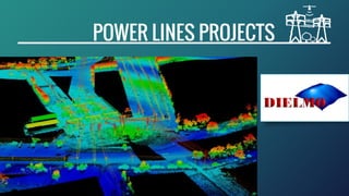
Power line LiDAR Mapping projects
•Download as PPTX, PDF•
1 like•1,510 views

DIELMO 3D provides sophisticated and highly accurate power line mapping products and corridor mapping solutions for the electricity industry both for distribution and transmission power lines. We are a specialized LiDAR analysis company with more than 50.000 km of experience in LiDAR processing for power lines, offending vegetation detection and PLS-CADD modelling among others.

Recommended
More Related Content
What's hot
What's hot (20)
Similar to Power line LiDAR Mapping projects
Similar to Power line LiDAR Mapping projects (20)
Recently uploaded
Recently uploaded (20)
Power line LiDAR Mapping projects
- 1. LiDAR POWER LINE PROJECTS
- 2. MAIN PRODUCTS REPORTS PLS-CADD MODELLING LiDAR CLASSIFICATION & NETWORK UPDATE OFFENDING VEGETATION DETECTION & GROUND CLEARANCE ANALYSIS CLOUD SERVICES
- 3. OUR EXPERIENCE AND BACKGROUND FLEXIBLE IN-HOUSE SOFTWARE CUSTOMIZED PRODUCTS AND SERVICES BEST QUALITY COMPETITIVE PRICING QA/QC 99.99% ACCURACY INTERNATIONAL EXPERIENCE + 85.000 KM With more than 85.000 km of experience in power line projects, we leverage extensive experience for your project. The ability to adjust our software to provide LiDAR processing solutions, matching any client needs makes us an attractive alternative to classic LiDAR processing.
- 4. LIDAR PROCESSING STEPS Delivery of raw LAS files. Auto classification of raw data Measure FL and Z errors in overlaps. Flight line adjustment in Z. Check and correct errors in XY. Select FL to refly Intensity image and objects > 3m mask. 2D vector of poles and conductors. QA of vectors with objects > 3m mask and reference vectors Check non capture regions Report non capture regions if necessary Select Study Data from Total Data Pool and Auto-classify Poles and Conductors Apply the flight line adjustment. LAS manual editing. Roads vectors. QA of vectors / Ids Compute PI and ground QA. QA of LAS classification Compute and edit patches. 2D vector of crossings. Prepare vectors to compute offending Vegetation (OV). Compute OV v1 QA of OV v1 Edit errors detected in OV v1. Recompute OV v2 Second QA of OV2. Edit errors detected in OV2. Compute the OV volume by span Prepare delivery of Offending Vegetation. Delivery of Offending Vegetation. Compute Report Premodeling QA of Report Premodeling. Edit errors detected in report pre-modeling. Insert Roads and MKP in LAS files. QA of overlaps with other Blocks. Prepare delivery of the other products. Delivery of the other products. 2- LiDAR CLASSIFICATION, QUALITY CONTROL, OFFENDING VEGETATION AND ERRORS CORRECTION 1- DATA PREPARATION AND CORRECTION BEFORE CLASSIFICATION 3- PRE-MODELLING, REPORTS AND FINAL PRODUCTS GENERATION 6 working days 7 working days 8 working days
- 5. DATA RECEPTION & PREPARATION LIDAR PROCESSING STEPS 1- DATA PREPARATION AND CORRECTION BEFORE CLASSIFICATION FLIGHT LINES & OVERLAPS ANALYSIS AND CORRECTION CHECK NON CAPTURED REGIONS 2D VECTORS DESIGN & QA FOR POLES AND WIRES
- 6. LIDAR PROCESSING STEPS LAS EDITION, QA/QC AND CORRECTION 2- LiDAR CLASSIFICATION, OFFENDING VEGETATION AND QUALITY CONTROL CROSSING, ROAD VECTORS & OTHER FEATURES QA/QC OF NETWORK VECTORS (OV) OFFENDING VEGETATION CALCULATION & QA/QC
- 7. REPORTS GROUND CLEARANCE & PRE-MODELLING INSERT FEATURES & OVERLAP CHECKING FINAL DELIVERY LIDAR PROCESSING STEPS 3- FINAL PRODUCT GENERATION, REPORTS, PRE-MODELLING AND QA
- 8. THE BEST SOLUTION TO EACH PROJECT PLS-CADD MODELLING CLOUD & ONLINE SOLUTIONS OTHER SERVICES FOR POWER LINES
- 9. POINTS TREES CLASSIFICATION DEACTIVATION INSERT SUPPORT SECTIONS CREATION LINE AT 50º LINE AT 75º RE-INSERTING TREES PLS-CADD MODELLING ACCURATE NETWORK MODELLING AND ANALYSIS FOR YOUR PROJECT
- 10. CLOUD & ONLINE SOLUTIONS ONLINE PROJECTS, CLOUD SERVERS AND GEO-LINKS FOR POWER LINES LiDAR DATA SERVERS GIS WEB PORTALS ONLINE GIS PROJECTS & TOOLS GEO-LINK CLOUD SERVICES
- 11. ONLINE DATA MANAGEMENT AND PUBLICATION LiDAR DATA SERVER & WEB PORTALS LiDAR, Raster & Vector Web Portal customization Online tools, 3D and more Content Manager SEE VIDEO ONLINE
- 12. CLOUD SERVICES GEO-LINKS CLOUD DOWNLOAD PDF ONLINE HERE