The establishment of the Regional Soil Partnership for MENA region, INRA Morocco - Mahmoud Alferihat
•
1 like•356 views

http://www.fao.org/globalsoilpartnership This presentation was made during the NENA soil partnerhip Conference that took place in Amman, Jordan 17-19 June 2014. This presentation was made by Dr. Rachid Moussadek , and it has the objective to present Status of soil survey and soil information system in Morocco. ©FAO: http://www.fao.org

Recommended
Recommended
More Related Content
What's hot
What's hot (20)
Similar to The establishment of the Regional Soil Partnership for MENA region, INRA Morocco - Mahmoud Alferihat
Similar to The establishment of the Regional Soil Partnership for MENA region, INRA Morocco - Mahmoud Alferihat (20)
More from FAO
More from FAO (20)
Recently uploaded
Recently uploaded (20)
The establishment of the Regional Soil Partnership for MENA region, INRA Morocco - Mahmoud Alferihat
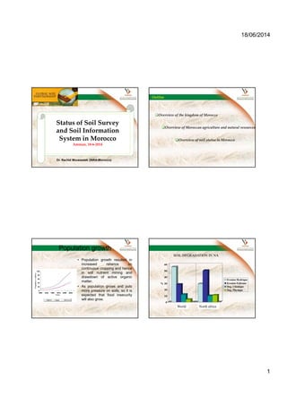
- 1. 18/06/2014 1 Status of Soil Survey and Soil Information System in Morocco Amman, 18-6-2014 Dr. Rachid Moussadek (INRA-Morocco) Outline Overview of the kingdom of Morocco Overview of Moroccan agriculture and natural resources Overview of soil status in Morocco Population growth • Population growth resulted in increased reliance on continuous cropping and hence in soil nutrient mining and drawdown of active organic matter. • As population grows and puts more pressure on soils, so it is expected that food insecurity will also grow. 0 20 40 60 80 100 Populationinmillions 1900 1925 1950 1975 2000 2025 Years Algeria Egypt Morocco 0 10 20 30 40 50 60 % Monde Afrique du Nord Erosion Hydrique Erosion Eolienne Deg. Chimique Deg. Physique SOIL DEGRADATION IN NA World North africa
- 2. 18/06/2014 2 Food shortage • The annual rate of increase (change) in yield does not keep pace with the annual rate of increase of the population and explains the ever- increasing shortage of food supply in the region. • Net wheat imports have jumped from 4.8 millions tons (1970); to 9 Mt (1977) and reached 25 Mt (2000) in North Africa and Meadle East. Morocco The Kingdom of Morocco : 710 850 km² area and 3 500 km of coastline (Atlantic ocean and Mediterranean sea) 30 Millions people ; 55 % living in urban areas. Morocco Administration: 16 Regions 71 Provinces (26 are Urban) 1547 Communes (249 are Urban) Economy: Agr.: 40% of labor force Ind.: 7,2% of labor force Serv.: over 50% of GDP Moroccan agriculture Distribution of agricultural land Uncultivated 44% Rangelands 30% Forest 8% Alfalfa 5%Agricultural lands 13% Rainfed 88% Irrigared 12% 9 Millions Ha Favorable rainfed 33% Unfavorable rainfed 67% Source : Directionof VegetalProduction,Source : Directionof VegetalProduction, Ministry of Agriculture of MoroccoMinistry of Agriculture of Morocco
- 3. 18/06/2014 3 • Before the political independence of Morocco in 1956, foreign pedologists performed most of the soil observations and mapping for both scientific purposes and management needs. • The National Office of Irrigation (ONI) did the first real soil surveys for the selection of potentially irrigable land. Large regions, such as Sebou, Oum Er-Rbia, and Moulouya watersheds were first surveyed at the reconnaissance scale (1:500,000 to 1:100,000). Status of Soil survey • The total area covered by soil survey is estimated to 20 Millions ha. It is mostly concentrated in the North and central western part the country, north of the Atlas Mountains. Therefore, at present, only about 28 % of national soil resources are mapped and characterised at different scales. The French soil classification system (CPCS of 1967) is almost the unique legend used. A schematic general soil map of Morocco was prepared at the scale of 1:2,000,000. Exemple of Soil Maps Maps (1/500.000)
- 4. 18/06/2014 4 Map (1/2M) Moroccan natural resources Soil National irrigated agriculture program launched in 1967 1/20.000 and 1/10.000 soil maps covering 2.5 millions Ha National rainfed areas development program launched at 80s 1/50.000 and 1/100.000 soil maps covering 6.12 millions Ha Moroccan dominant soils: 1 – North and North-West: Luvisols, Vertisols, Kastanozems, Chernozems, Phaeozems, Cambisols 2 – South and South-East: Lithosols, Regosols, Rendzinas, Xerosols, Yermosols, Fluvisols
- 5. 18/06/2014 5 WRB-National classification correlation Step 1. Determination of possible correlations of national soil types with WRB RSGs Step 2. Define all required data & information for the possible WRB RSGs in table format Step 3. Select the relevant ones for the climatic, geographical region. Step 4. Define the missing data (and/or diff. methodology) Step 5. Define the possible supplement data & information (pedotransfer functions, expert/correlator judgment, or additional field visit) Step 6. Define diagnostics or directly WRB reference groups Step 7. Same exercise for qualifiers → local WRB experts (correlator?) needed
- 6. 18/06/2014 6 WRB Leptosols Regosols Calcisols Kastanozems Vertisols Etc…. Major soils in Morocco • Although Soil Taxonomy, FAO and WRB classifications are partially known by most pedologists (courses of soil classification), the French soil classification is the only system used for official soil survey in Morocco. Only scientific studies use FAO or Soil Taxonomy conversions for publication requirements. Major soil constraints affecting sustainable agricultural production and development • Soil erosion is the most important soil degradation process in Morocco. The total annual soil loss is evaluated to 100 millions tons. • Soil depth (limits soil depth). This is a major constraint limiting the agricultural arable land in Morocco. A survey per-formed in different regions of the country showed that about 2 millions ha could be re-claimed by subsoiling and stones removal.
- 7. 18/06/2014 7 Soil quality changes in irrigated perimeters Many studies conducted in the irrigated perimeters have shown that irrigation leads generally to soil and water quality deterioration. The major degradations are: • Salinisation, surface sealing, rising of saline groundwater, reduction of soil drainage, soil compaction. At present, the surface area of saline soils is estimated to about 0,5 Mha. • Loss of organic matter. A mean soil organic matter is low than 2 % Soil inventory database • Although the importance of soil information was recognised from a long time, the availability of data on soils was always difficult to get and to use. A special effort therefore was made by the Ministry of Agriculture/INRA to establish a database for all the soil information available. • In order to establish a general soil map of Mo- rocco, it is necessary to normalise the legend. Pedologists are invited to use the normalised descriptions, symbols, and interpretation norms. Unified colours are also proposed for the pedologic map and the constraints map. This soil database needs to be updated now to introduce the new studies realised during the last years (2 Mha). • The Moroccan soil information system needs to be improved by: • Updating the existent soil database; • Establishment of new specialised national and regional GIS laboratories to improve the storing capacity and interpretation of soil information; • Training of pedologists and technicians for soil database establishment and use; • A national program of soil inventory and mapping is needed to complete soil survey in Morocco and to co- ordinate the activity between specialised scientific institutions, research centers, and the administration.
- 8. 18/06/2014 8 INRA Soil Projects : Land Evaluation for rainfed agriculture INRA Soil Projects : Land Evaluation for rainfed agriculture INRA Projects : National agricultural soils’ fertility map Thank you Dr. Rachid MOUSSADEK moussa.inra@gmail.com