Innovative Friendly Roads Project
•Download as PPT, PDF•
0 likes•321 views

This document describes the Friendly Roads project in Georgia, which aims to make roads safer. It notes that road accidents are a major cause of death globally and in Georgia. The project uses a mobile phone app and web platform to allow citizens to report hazardous road infrastructure and traffic accidents. These reports are mapped and analyzed to identify "black spots" to prioritize for improvement. The goal is to involve citizens and local decision-makers to jointly resolve local traffic safety issues through a data-driven approach. Since launching, the Friendly Roads project has eliminated 15 black spots and created the first online platform for citizen-reported road hazard data in Georgia.

Recommended
Recommended
More Related Content
What's hot
What's hot (20)
Similar to Innovative Friendly Roads Project
Similar to Innovative Friendly Roads Project (20)
More from Gela Kvashilava
More from Gela Kvashilava (20)
Recently uploaded
Recently uploaded (20)
Innovative Friendly Roads Project
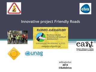
- 1. Innovative project Friendly Roads თბილისი 2014 ©SafeDrive
- 2. Why do we need friendly roads?Why do we need friendly roads? More than 1 million road traffic casualties each year Eighth leading cause of death globally Leading cause of death for people between 15 and 29 years of age Causes a loss of up to 3% of GDP More than 1 million road traffic casualties each year Eighth leading cause of death globally Leading cause of death for people between 15 and 29 years of age Causes a loss of up to 3% of GDP
- 3. Accidents and Fatality Rates in GeorgiaAccidents and Fatality Rates in Georgia People per 10,000 vehicles during 2004-2012People per 10,000 vehicles during 2004-2012
- 4. ConsequencesConsequences The road death rate of 13.4 per 100,000 people (2012) is at least 4 times higher than that of global leaders Road traffic injuries are one of the top 10 causes of death - 605 deaths in 2012 The socio-economic cost of road crashes is estimated to be between 1%-1.5% of GNP The road death rate of 13.4 per 100,000 people (2012) is at least 4 times higher than that of global leaders Road traffic injuries are one of the top 10 causes of death - 605 deaths in 2012 The socio-economic cost of road crashes is estimated to be between 1%-1.5% of GNP
- 5. KeyKey causescauses Hazardous road infrastructure (“black spots”) Lack of education on safe driving behavior Lack of structured data collection on: Local traffic hazards (black spots) Seasonal effects Accidents Causes: Speeding Alcohol consumption Insufficient street lighting Etc. Best practices Hazardous road infrastructure (“black spots”) Lack of education on safe driving behavior Lack of structured data collection on: Local traffic hazards (black spots) Seasonal effects Accidents Causes: Speeding Alcohol consumption Insufficient street lighting Etc. Best practices
- 6. DECADE GLOBAL PLANDECADE GLOBAL PLAN Five pillars for a Safe Systems approach Road Safety Management Safer User behaviour Safer Roads & Mobility Safer Vehicles Post-crash response
- 7. Decade Global Plan: Safer Roads & MobilityDecade Global Plan: Safer Roads & Mobility Pillar 2 – IndicatorsPillar 2 – Indicators Number of countries with a target to eliminate high risk roads by 2020 Number of countries with systematic safety audit/safety assessment policies in place Number of countries with a defined allocation of funding for infrastructure safety Number of countries implementing sustainable mobility programs International Road Assessment Programme estimates that 1 million death and serious injuries per year can be prevented if 10% of all high risk roads are fixed Number of countries with a target to eliminate high risk roads by 2020 Number of countries with systematic safety audit/safety assessment policies in place Number of countries with a defined allocation of funding for infrastructure safety Number of countries implementing sustainable mobility programs International Road Assessment Programme estimates that 1 million death and serious injuries per year can be prevented if 10% of all high risk roads are fixed
- 8. ““Megobruli Gzebi” (Friendly Roads)Megobruli Gzebi” (Friendly Roads) A mobile phone and web platform engaging citizens to:A mobile phone and web platform engaging citizens to: Report hazardous traffic infrastructure and accidents in their area (e.g. potholes, insufficient street lighting, a lack of speed bumps close to a school etc.), using SMS, web input, the “Megobruli Gzebi” Smartphone app, email, Twitter and Facebook; Sign up for SMS and email alerts notifying them about hazardous traffic infrastructure in their area; Connect with local decision makers to jointly analyse and resolve local traffic hazards. A mobile phone and web platform engaging citizens to:A mobile phone and web platform engaging citizens to: Report hazardous traffic infrastructure and accidents in their area (e.g. potholes, insufficient street lighting, a lack of speed bumps close to a school etc.), using SMS, web input, the “Megobruli Gzebi” Smartphone app, email, Twitter and Facebook; Sign up for SMS and email alerts notifying them about hazardous traffic infrastructure in their area; Connect with local decision makers to jointly analyse and resolve local traffic hazards.
- 9. How does it work?How does it work? Citizens report using SMS, web form, friendly roads smartphone app, email, Twitter or Facebook All reports are automatically analyzed and aggregated All reports are displayed on the friendly roads web platform: Interactive map Intuitive data visualizations Photos and videos submitted by citizens Citizens report using SMS, web form, friendly roads smartphone app, email, Twitter or Facebook All reports are automatically analyzed and aggregated All reports are displayed on the friendly roads web platform: Interactive map Intuitive data visualizations Photos and videos submitted by citizens
- 10. How is the data being used?How is the data being used? Resolution of local hazards – involving decision makers and participating citizens Analytical reports Advocating safer roads with donors, local authorities and citizens Resolution of local hazards – involving decision makers and participating citizens Analytical reports Advocating safer roads with donors, local authorities and citizens
- 11. Friendly RoadsFriendly Roads web & mobile phone toolweb & mobile phone tool megobruligzebi.gemegobruligzebi.ge
- 13. Friendly roads online map 170 Reports from local communities
- 14. Our Partners
- 15. Meeting with students, local communities, academia and government officials
- 16. Extensive media coverage road of the project • Video place
- 17. Results of the project Friendly Roads 15 Black Spot eliminated Online web portal www.megobruligzebi.ge created First Georgian guide published.
- 19. Together we make our roads safe!