1. Pg A1 final blk 8.31 CYAN MAGENTA YELLOW BLACK
Pg A1 sun daily 8.31 CYAN MAGENTA YELLOW BLACK
Single Family HomeS leHigH acreS mid $100’S
(239) 303-7012 drhorton.com
¸ INDEX
Classifieds . F1-12
Comics . . . Inside
Dear Abby . . . . E4
Lottery . . . . . . . B2
Nation . . . . . . . A4
Obituaries . . . B11
Opinion . . . B12-13
The News-Press,
A Gannett Newspaper
Copyright 2008
¸ For live
Doppler radar
and updates
throughout
the day go to
news-
press.com.
THE NEWS-PRESSSUNDAY, AUGUST 31, 2008 | PUBLISHED SINCE 1884 news-press.com FINAL | $1.50
It’ll be
slow at
airport
in Sept.
BY LAURA RUANE
lruane@news-press.com
Southwest Florida Internation-
al air service in September will
not be “a pretty picture.”
That’s according to Carol
Obermeier, airport market devel-
opment manager.
Airline seat availability —
“capacity” in aviation jargon —
will drop more than 16 percent
year over year in September,
according to an analysis Ober-
meier did for The News-Press.
The good news is the picture
appears to improve with each
successive month, culminating in
a 6.7 percent capacity increase in
flights for December.
At least that’s how it looked as
of Friday.
“With the way the economy is
going now, these numbers change
week to week,” Obermeier said,
But seat availability
will take off soon after
MONSTERINTHEGULF
SPECIAL REPORT: HURRICANE GUSTAV
THE ASSOCIATED PRESS
¸ Jeffrey Vannor carries belongings while evacuating Saturday at the Greyhound Bus and Amtrak station in New Orleans as Hurricane Gustav approaches. A mil-
lion people took to Gulf Coast highways, boarding up homes and businesses and fleeing dangerous Hurricane Gustav by bus and car.
Heavy rain
is a drain
on Bonita
BY DAVE BREITENSTEIN
dbreitenstein@news-press.com
Picture a giant bathtub, filled
to the brim.
Despite its enormity, the tub
features just one tiny drain. To
complicate matters, the faucet
won’t shut off.
Bonita Springs is the drain.
The tub is a 315-square-mile
waterlogged region of South-
west Florida.
Bonita’s main waterway, the
Imperial River, is unable to
channel millions of gallons of
rainwater from Tropical Storm
Fay out to sea.
Thirteen years after Bonita’s
last major flood, and $106.4 mil-
lion later, a bevy of flood control
and restoration projects still
couldn’t stop the water from Fay
from flooding the same Bonita
neighborhoods.
“The idea is to have multiple
drains,” said Phil Flood, director
of South Florida Water Manage-
ment District’s lower west coast
division. “But being one big
¸ PHOTO GALLERIES:
View scenes from Cuba as Gustav
slams ashore as a Category 4.
¸ PHOTO GALLERIES:
View preparation along Gulf Coast,
including New Orleans evacuation.
¸ HURRICANE GUIDE 2008:
View latest tracking maps, news,
preparedness tips for your family.
¸ TEXT MESSAGE ALERTS:
Sign up for tropical weather news
at news-press.com/text.
¸ See AIR SERVICE A2
¸ Also see local ups, downs A2
¸WEATHER
High 88 Low 77
Showers and storms,
80 percent chance of
rain; forecast B14
INSIDE
Railroad ties to history
AnewbookbyFortMyershistorian
GreggTurnerdetailshowFloridaowes
muchofitshistorytotherailroad.
¸ TROPICALIA
¸ See FLOODS A12
¸ Also see Bonita flooding A12
¸ Also see Sam Cook column
B1
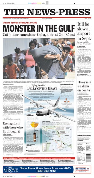
Cat 4 hurricane slams Cuba, aims at Gulf Coast
Eyeing storm
with those who
fly through it
BYMARYWOZNIAK
mwozniak@news-press.com
As Hurricane Gustav strengthens into a mon-
ster, Hurricane Hunter aircraft are flying ’round-
the-clock into the thick of the storm and straight
into the cauldron of its mysterious eye.
The News-Press flew on the Hurricane Hunter
Friday as Gustav developed from a youthful trop-
ical storm into a mature, powerful hurricane with
potential to devastate life and property.
During the Hurricane Hunter’s flight, we
watched and spoke with the six-member crew
and learned about the crew members’ individual
jobs. We rode in the cockpit with pilots and navi-
gator. Most dramatically, we experienced beaking
throughroilingwindsoftheeyewallfourtimesto
fly across its broad expanse and back out again.
¸ See HURRICANE A11
TheNews-Pressandwirereports
HAVANA— Gustav slammed into Cuba’s tobac-
co-growingwesterntipasamonstrousCategory4
hurricane Saturday while both Cubans and Amer-
icans scrambled to flee the storm as it roared
toward the oil-rich Gulf of Mexico and New
Orleans.
Ray Nagin, the mayor of New Orleans, onSat-
urday night ordered an evacuation of the
city that becomes effective at 8 a.m. today.
Forecasters said Gustav was just short of
becoming a top-scale Category 5 hurricane as it
hitCuba’smainlandSaturdayafterpassingoverits
Isla de la Juventud province, where shrieking 150-
mph winds toppled telephone poles, mango and
almond trees and peeled back the tin roofs of
homes.
Isla de la Juventud civil defense chief Ana Isla
said there were “many people injured” on the
island south of mainland Cuba, but no reports of
deaths. She said nearly all its roads were washed
out and some regions were heavily flooded.
“It’s been very difficult here,” she said on state
television.
Authorities evacuated at least 300,000 people
from western Cuba, including Isla de la Juventud.
Jaime Iparraguirre’s in-laws, who live on the
west coast of Cuba, have been evacuated because
of the hurricane.
¸ See GUSTAV A11
¸ Also see New Orleans evacuates A4
news-press.com/hurricane: Expanded storm coverage online; view more photos from New Orleans
2. The wild and dangerous flight
provides continuous, precise
measurements of atmospheric
conditions to the National Hurri-
cane Center. That allows the cen-
ter, in turn, to more accurately pre-
dict the hurricane’s path and pin-
point specific areas that will have
to go under mandatory evacuation
orders.
The greater accuracy saves the
money and resources of unneces-
sary evacuation costs and the
nerves of people who otherwise
might have to leave their homes.
For most of the hunters, this is
whattheyliveforandarewillingto
die for. They have no parachutes,
sinceitwouldbefoolhardytojump
to safety amid hurricane winds. It’s
bettertoditchtheplaneandrelyon
life vests, lifeboats, and prayer to
survive the high seas below.
The Hurricane Hunter is flown
by the 53rd Weather Reconnais-
sance Squadron of the Air Force
Reserve. It is a one-of-a kind unit
under the Department of Defense,
and has flown into tropical storms
and hurricanes since 1944.
The reservists are part of the
403rd Wing based at Keesler Air
Force Base in Biloxi, Miss.
But on Friday we flew from
Homestead Air Reserve Base.
When we began the flight at 11:15
a.m., Gustav’s winds were meas-
ured at 65 mph.
During the 101
⁄2-hour flight,
winds strengthened to a Category
1 hurricane at about 72 knots, or
about 83 mph. Since we landed at
9:45 p.m. Friday, the storm has cat-
apulted into a Category 4 hurri-
cane at 150 mph.
Fasten your seat belts. It’s going
to be a bumpy ride.
8:30a.m.:Meettheboss
We get to Homestead well
before our designated arrival time
and have a chance to speak with
Maj.JeffRagusa,thedeployedmis-
sion commander in charge of all
hurricane operations flying from
Homestead.
Nobody flies at the top of a hur-
ricane, Ragusa said.
“They want to know what hap-
pensatthebottomofit,”hesaid.“If
NOAA (National Oceanic and
Atmospheric Administration) had
its way, we’d fly 4 feet above the
water.”
Instead we’re to fly at 10,000
feet, to see where the maximum
and most dangerous winds are.
TheHunterisaWC-130Jaircraft,a
newer model of the C-130. The
plane also is newly equipped with
the Stepped-Frequency
Microwave Radiometer, dubbed
SMURF. The technology allows
the Hurricane Hunters to con-
stantly measure surface winds
directlybelowtheaircraftandhelp
increase the accuracy of the
National Hurricane Center’s fore-
casts by 30 percent.
Since it costs $1 million to evac-
uate a mile of coastline, the
increased accuracy saves govern-
ment dollars as well as helping
people know more precisely
whether the storm will hit their
homes, said Maj. Chad Gibson,
spokesman for Keesler Air Force
Base.
The storm’s circulation is
already counter-clockwise, but
no well-formed eye is apparent
yet, Ragusa said. The Hunter’s
target is the western tip of
Jamaica.WehavetoflyoverCuba
to get there. The State Depart-
ment has to secure overflight per-
mission from the Cuban govern-
ment to do it.
The plane will fly in an X or
Alpha pattern, going 105 miles out
from the outskirts of the storm to
its center, then back out again,
repeating the pattern for all four
quadrants of the storm.
9:25a.m.:Thebriefing
Ragusa introduces the six-
member crew at his pre-flight
briefing. They are:
¸Lt.Col.C.FloydPlash,aircraft
commander and pilot;
¸ Capt. Nate Gasscock, a pilot;
¸ Lt. Col Dan Jones, pilot;
¸ Capt. Eileen Bundy, aerial
reconnaissance weather officer;
¸ Mike Anderson, navigator;
¸ Sgt. Major Justin Jones, the
dropsonde system operator;
The dropsonde is the major
measurementinstrumentthecrew
uses to send information directly
to the National Hurricane Center,
like air pressure, wind speed and
other data. The instrument is a
small cylindrical device with a
parachute on the end.
Once released from bottom of
the aircraft, it floats down 2,500
feet a minute and sends back radio
data, Jones said.
Gustavisstillatropicalstormat
this point, Ragusa said. The circu-
lation of winds is counter-clock-
wise but the eye is ragged and not
fully formed.
“Every ride is a bumpy ride,” he
said. “As you walk through the air-
craft, always keep an eye out for
something to grab onto.”
“Just remember, air sickness is
just part of flying,” said Lt. Col.
Tom Davis, spokesman for Home-
stead Air Reserve Base.
11:05a.m.:Takeoff
This plane is massive, with abil-
ity to plow through winds at more
than370mph.Butthestormisbig-
ger.
The inside of the Hunter is like
a giant, stripped-down tin can.
The plane’s wiring and insulat-
ed pipes can be seen in the ceiling.
The seats are simply red canvas
benches lining either side of the
fuselage with a back of red web-
bing — something to hang onto.
All of the cargo is tied down,
including cardboard boxes full of
the dropsondes. Sgt. Major Justin
Jones pulls out five of them in
preparation, large cardboard cylin-
ders wrapped in foil and pink bub-
ble wrap.
Theplanevibratesinplacewith
its brakes on, as the four propeller
enginesarerevved.Thenitlurches
forwardatfullspeedonthebumpy
runway.
The claw-like propellers
become a blur. The noise inside is
a steady, high-pitched hum. Davis
distributes earplugs.
The black nose cone lifts into
the air.
Like a flight attendant, Master
Sgt.Jonessignalsthelocationofair
sickness bags in little brown
envelopes. He pulls one out and
demonstrates the procedure.
The bathroom is at the back of
theplanebehindagreencurtain.It
looks like the curtained control
room in Emerald City where
Dorothy discovered the hiding
Wizard of Oz.
1:25p.m.:Theflight
The Hurricane Hunter flies for
about two hours, straight across
the olive-green landscape of Cuba.
The plane cuts between the cities
of Cabaiguan and Moron, just
skirting the city of Ciego De Avila.
As we came off the coast and
headed for Jamaica, just off Mon-
tegoBay,theturbulencestarts.The
massive WC-130J was buffeted like
a toy. The drops in altitude were
sudden — about 200 feet at a time.
Jones ejects the dropsondes
from the plane about every five
minutes. Each one is tracked by a
satellite frequency and its progress
is displayed by a colored graph on
his computer monitor.
They cost $700 each, he says,
but the cost is worth the data they
provide and the lives they save.
The Hunter gets six different
views of radar from cameras pro-
viding different angles. Another
screen displays what all four
enginesaredoing,fromhorsepow-
er to oil pressure.
Above the emergency exit to
the right of Jones’ computer con-
sole is a sign that reads: “ground
and ditching use only.”
Theeyeisentered
The plane shakes and begins to
go from side to side. We must be
penetratingtheeyewallforthefirst
time, the roughest point of the trip.
Davis calmly munches on
crackers from a plastic sandwich
bag, then kicks back and closes his
eyes for a few minutes.
Thehurricaneeyealmostdefies
description.
The eye may be the center of a
deadly force of destruction, but
witnessing its scope and majesty
inspires awe. The massive ring of
cloudsformedthebanksofawide,
emptylakeofnothingness,savefor
a few scudding clouds.
Other images flood the mind: A
white-coiled snake ready to strike.
The crater of a volcano with puffs
of cloud floating like steam. You
can see through them below to the
boiling blue lava of a stormy sea.
The eye changed each time we
flew through it. At first its curve
remained raggedy and the circle
was incomplete. Then it formed
into a rough circle about 25 miles
across.Bythefourthandfinalpass,
itbecamemoredefinedasasmall-
er, tighter circle.
“Is that the eye wall? It had an
inner spiral the last time. This
could be the same thing,” said
Plash, the mission commander, as
the Hunter made the final pass-
through at 7 p.m..
“Yeah, that’s it,” said Gasscock,
the pilot sitting beside him.
The job was done — until their
next shift 18 hours later. We flew
home.
As the storm strengthens, the
crews’ shifts will shorten to six
hours, then three hours round-the-
clock instead of the standard 8-10
hours, said Lt. Col. Dan Jones, a
pilot.
Whyfly?
The crew members have differ-
ent reasons for being here. They
includepatriotism,fulfillingalong-
held dream, trying to conquer a
childhood fear of severe weather,
or simply working near the place
where their families live.
“GrowingupIwas oneofthose
kids who was afraid of weather,”
said Capt. Eileen Bundy, aerial
reconnaissance weather officer.
So she went into meteorology
and ended up flying into hurri-
canes, “making my mom real
happy,”she joked.
“It’s getting pretty personal to
me,”Gasscocksaid.Hiswifeaswell
as other families of crew members
who live near the base in Biloxi are
having to evacuate in the path of
Gustav—whiletheycontinuetofly.
ButGasscockknowstheworkis
important to keep their families as
well as hundreds of thousands of
other residents safe.
When asked his motivation for
being a Hurricane Hunter, Gass-
cock pointed to his jumpsuit
sleeve, where an American flag
patch was sewn.
“Right there,” he said.
¸ Continued from A1
HURRICANE
Pg A11 CYAN MAGENTA YELLOW BLACK
Pg A11 CYAN MAGENTA YELLOW BLACKPg A11 CYAN MAGENTA YELLOW BLACK
Pg A11 CYAN MAGENTA YELLOW BLACK
Pg A11 CYAN MAGENTA YELLOW BLACKPg A11 CYAN MAGENTA YELLOW BLACK
Pg A11 CYAN MAGENTA YELLOW BLACK
Pg A11 CYAN MAGENTA YELLOW BLACKPg A11 CYAN MAGENTA YELLOW BLACK
Pg A11 CYAN MAGENTA YELLOW BLACK
Pg A11 CYAN MAGENTA YELLOW BLACKPg A11 CYAN MAGENTA YELLOW BLACK
Pg A11 blk CYAN MAGENTA YELLOW BLACK
Pg A11 CYAN MAGENTA YELLOW BLACKPg A11 CYAN MAGENTA YELLOW BLACK
PHOTOS BY MARC BEAUDIN/THE NEWS-PRESS
¸ Clouds from Hurricane Gustav form over the Caribbean Sea between Jamaica and the Cayman Islands late Friday, as a Hurricane Hunter plane flies over to collect data for the National Hurricane Center.
¸ Lt. Mike Anderson, a co-pilot, scans the perimeter Friday while
flying a mission in the Caribbean Sea and into Hurricane Gustav.
“Right now they’re staying in a
shelter the government is provid-
ing,” said Iparraguirre, who is the
ownerofJJHabanaCafeinLehigh
Acres.
On Friday, Iparraguirre’s in-laws
toldhimtheonlyeffectofthestorm
they were feeling was rain. But he
said he was sure conditions would
become different Saturday.
“We’re going to try to talk to
them,” he said.
Bonita Springs resident Ive Val-
ladares said she had received an e-
mail from one of her aunts who
lives in Havana City, Cuba, a few
days ago, telling Valladares the
storm’seffects,besidesrain,hadyet
to reach them.
Valladares said she is worried
about her family, but understands
there isn’t much she can do.
“We Cubans are so used to hur-
ricanes,” she said. “We just get
ready and wait.”
Gisel Garcia’s entire family still
livesinthecentralpartofCuba.But
Garcia, who lives inCape Coral,
said he wasn’t worried about his
family, and said he hadn’t spoken
with them yet.
Garcia said he would probably
get in touch with his family after
the hurricane had passed through
to make sure they were all right.
“We always start crying when
nothing happens,” he said. “Why
should we start crying before any-
thing happens?”
Gustav was projected to plow
into the Gulf of Mexico at full
force today, and reach the U.S.
coast as early as Monday after-
noon. A hurricane watch was
issued from Texas to the Florida-
Alabama line.
More than a million Americans
made wary by Hurricane Katrina
took buses, trains, planes and cars
as they streamed out of New
Orleans and other coastal cities,
where Katrina killed about 1,600
people in 2005.
Gustavalreadyhaskilled81peo-
ple by triggering floods and land-
slides in other Caribbean nations.
The U.S. National Hurricane
CentersaidGustavcouldbecomea
Category 5 hurricane soon, with
winds above 155 mph.
Cuba’s top meteorologist, Jose
Rubiera, said the hurricane’s mas-
sive center made landfall in main-
land Cuba near the community of
Los Palacios in Pinar del Rio — a
region that produces much of
Cuba’s famed tobacco and cigars.
In Pinar del Rio, the storm
knocked down power lines, shat-
tered windows and blew the roofs
off some small homes.
Rubiera said the storm would
bring hurricane-force winds to
much of the western part of
Havana, Cuba’s capital, where
power was knocked out as winds
blasted sheets of rain sideways
though the streets and whipped
angrywavesagainstthefamedsea-
side Malecon boulevard.
Felled tree branches and large
chunks of muddy earth littered
crowded roads.
Cuba grounded all domestic
flights and halted all buses and
trains to and from Havana, where
some shuttered stores had hand-
scrawled “closed for evacuation”
signs plastered to their doors.
Authorities boarded up banks,
restaurants and hotels, and resi-
dents nailed bits of plywood to the
windowsanddoorsoftheirhouses
and apartments.
“It’sverybigandwe’vegottoget
readyforwhat’scoming,”saidJesus
Hernandez, a 60-year-old retiree
who was using an electric drill to
reinforce the roof of his rickety
front porch.
The government announced it
was stepping up emergency pro-
duction of bread at state-run bak-
eries and lines formed all over the
city as Cubans waited for loaves.
In tourist-friendly Old Havana,
heavy winds and rain battered
crumblinghistoricbuildings.There
were no immediate reports of
major damage, but a scaffolding
erected against a building adjacent
to the Plaza de Armas was leaning
at a dangerous angle.
Lidia Morral and her husband
werevisitingCubafromBarcelona.
She said Gustav forced officials to
close the beaches the couple want-
ed to visit in Santiago, on the
island’s eastern tip. The storm also
prevented them from catching a
ferry from Havana to the Isla de la
Juventud on Saturday.
“It’s been following us all over
Cuba, ruining our vacation,” said
Morral.
By Saturday evening, Gustav
was about 65 miles west-southwest
of Havana and was moving north-
west at about 15 mph.
Hurricane-force winds extend-
ed out 70 miles in some places.
The U.S. Naval base at Guan-
tanamo Bay was hundreds of miles
to the east, out of the storm’s path.
As it passes by to the west of
Southwest Florida today, Gustav is
expected to bring a few downpours
andslightlyhigherwindstothearea.
Meanwhile, the hurricane cen-
ter said Tropical Storm Hanna
was projected to near the Turks
and Caicos Islands late today or
Monday, then curl through the
Bahamas by early next week
before possibly threatening
Cuba.
As it spun over open waters,
Hanna had sustained winds near
50 mph Saturday evening and the
hurricane center warned that it
could kick up dangerous rip cur-
rents along parts of the southeast-
ern U.S. coast.
— Staff writer Gabriella Souza and
The Associated Press contributed
to this report.
¸ Continued from A1
GUSTAV
*** THE NEWS-PRESS, NATION & WORLD, SUNDAY, AUGUST 31, 2008 | A11