3D City Models of London Compared

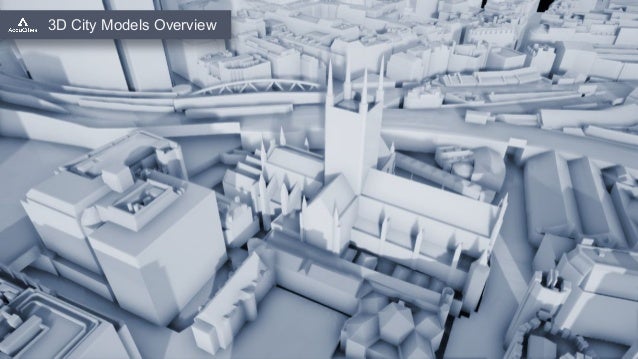
The term “3D model” is an overarching term covering everything from simple extruded map polygons models all the way to custom-made millimeter-accuracy 3D scans. The 3D models vary greatly in terms of their accuracy, level of detail, recency and usability, as well as in terms of their costs, delivery time and its file format. To make a direct comparison, the “Overview of 3D City Models for Architects” video offers an overlay of the same area of London represented in 5 different types of 3D city models. Extruded Buildings footprint Polygons 3D map. This is easy to obtain and possibly the simplest form of a 3D city model. It’s excellent for background models and wide-area city visualisations on a budget. Airborne Lidar model. A much more accurate and detailed model, however, it’s quite a messy and unseparated Digital Surface model dataset. Aerial photogrammetry. Made with clean geometry with a high level of detail, up to 15 cm accurate. This does come at a cost. Textured photogrammetry model. Textures applied onto clean geometry, an accurate city model with high visual fidelity. Might be cost-prohibitive and currently only available for London. Non-GIS Game-ready model. Not made for architecture or urban planning but very affordable with a surprising level of detail on landmark buildings. Part of RIBA CPD material: Video: 3D City Models Overview (28:08) https://www.ribacpd.com/accucities/230545/3d-city-models-overview/411006/movie More info: https://www.accucities.com/cpd

Recommended
Recommended
More Related Content
Recently uploaded
Recently uploaded (20)
Featured
Featured (20)
3D City Models of London Compared
- 1. 3D City Models Overview
- 2. Photogrammetry city model + Controlled accuracy + Good Level of detail + Up-to-date + Separated Features - Cost - Higher polycount Photogrammetry Textured model + Accurate geometry + High visual fidelity + 8k Textures - High cost - Large file size - Central London only Airborne Lidar model + Good Accuracy + Good Detail + Inexpensive - Unseparated model - High polycount - Messy geometry Game-ready Non-GIS model + Recognisable city + Hi-quality landmarks + Inexpensive - Patchy dataset - No OS map overlay - Limited use Extruded Polygons city map + 3D map + Inexpensive + Available - Very low detail - Database errors - Visibly inaccurate 3D City Models Overview
- 3. Urban Planning Plan.City Unreal Engine 4 Rapid Site Evaluation Data Overlays Data Exploitation Building Envelope 3D site models Planning Award winning Rapid 6 day delivery Over 210 customers 2,200 projects 3D City models Managed Library Fast 1 day delivery Growing every year Managed datasets Photogrammetry city models 15cm accuracy High Level of detail Up-to-date Easy to use Photogrammetry Textured models Innovative Dataset Accurate geometry High visual fidelity 8k Textures About AccuCities® 3D city models 3D City Models Overview
- 4. Extruded Polygons 3D map 3D City Models Overview
- 5. Airborne Lidar model + Good Accuracy + Good Detail + Inexpensive - Unseparated model - High polycount - Messy geometry Photogrammetry city model + Better Accuracy + Better Detail + Separated Features - Cost - Higher polycount Photogrammetry Textured model + Accurate geometry + Higher visual fidelity + Separated Features + Textures - Cost - Higher polycount Game-ready Non-GIS model + High quality model + Separated Features + Affordable - No map overlay - Higher polycount Extruded Polygons 3D map 3D City Models Overview
- 6. Extruded Polygons 3D map 3D City Models Overview Airborne Lidar model + Accurate Height + Accurate angles - Unseparated features - High polycount - Messy (News Bldg.) Photogrammetry city model + Better Accuracy + Better Detail + Separated Features - Cost - Higher polycount Photogrammetry Textured model + Accurate geometry + Textures + Separated Features - High Cost - Higher 3D model size Game-ready Non-GIS model + Better Detail + Separated Features - Cost - No map overlay - Visibly Inaccurate
- 7. Extruded Polygons 3D map 3D City Models Overview Airborne Lidar 3D model
- 8. Extruded Polygons City map + Separated features + Overlaps with OS map - Little detail - Little accuracy - Messy terrain geometry Photogrammetry city model + Accurate & Detailed + Separated Features + Trees layer + No residual geometry - Cost Airborne Lidar model + Accurate Height + Overlaps with OS map - Unseparated features - High polycount - Messy geometry Airborne Lidar 3D model 3D City Models Overview
- 9. Photogrammetry Textured model + Accurate geometry + Textures + Separated Features - High Cost - Higher 3D model size Game-ready Non-GIS model + Better Visual model + Textures on features - Cost - No map overlay - Inconsistent dataset Airborne Lidar model + Accurate Height + Overlaps with OS map - Unseparated features - High polycount - Messy geometry Airborne Lidar 3D model 3D City Models Overview
- 10. Airborne Lidar model + Inexpensive dataset - Out of date - Visibly inaccurate Extruded Polygons city map + Up-to-date + Overlaps with OS - Little detail - No raised rail track - Visibly inaccurate Inaccurate Non-GIS model + Up-to-date + Textures - No map overlay - No raised rail tracks Photogrammetry city model + Up-to-date + Accurate + Overlaps with OS + Raised rail tracks - Cost 3D City Models Overview Airborne Lidar 3D model
- 11. Photogrammetry 3D model 3D City Models Overview Airborne Lidar 3D model
- 12. Photogrammetry 3D model 3D City Models Overview Airborne Lidar model + Inexpensive dataset + Easy to process - Visibly inaccurate - Limited by technology - Difficult to improve Extruded Polygons city map + Overlaps with OS + Inexpensive - Very low detail - Database errors - Visibly inaccurate Game-ready Non-GIS model + High Quality model + Textures - Non-geo offset visible - Low quality surrounds
- 13. Photogrammetry 3D model 3D City Models Overview Textured Photogrammetry City Model
- 14. Textured Photogrammetry City Model 3D City Models Overview Airbourne Lidar model + Better Accuracy + Better Detail - Unseparated features - High polycount - Messy Photogrammetry city model + Better Accuracy + Better Detail + Separated Features - Cost - Higher polycount Photogrammetry Textured model + Accurate geometry + Higher visual fidelity + Separated Features + Textures - Cost - Higher polycount Game-ready Non-GIS model + Very high quality + Separated Features - Cost - No map overlay - Higher polycount Extruded Polygons map + Overlaps with OS + Inexpensive - Very low detail - Database errors - Visibly inaccurate
- 15. Game-ready Non-GIS model 3D City Models Overview Textured Photogrammetry City Model
- 16. Game-ready Non-GIS model 3D City Models Overview Airborne Lidar model + Better Accuracy + Better Detail - Difficult to work with - Unseparated model - High polycount - Messy geometry Photogrammetry city model + Better Accuracy + Better Detail + Separated Features + Trees layer - Cost - Higher polycount Photogrammetry Textured model + Accurate geometry + Higher visual fidelity + Separated Features + Textures - Cost - Higher polycount Game-ready Non-GIS model + Inexpensive + Hi Quality landmarks + Textured - Patchy coverage - No map overlay - Inaccurate close ups Extruded Polygons map + Overlaps with OS + Inexpensive - Missing Railroads - Very low detail - Database errors - Visibly inaccurate
- 17. Game-ready Non-GIS model 3D City Models Overview