Brief introduction to GIS software
•Download as PPTX, PDF•
0 likes•20 views

This document provides an introduction to full-featured GIS software. It explains that GIS software displays geographic data through visual features like colors and symbols but does not store the actual geographic information. The geographic information comes from databases and collections of raster data and shapefiles stored in an external file repository. It also gives examples of displaying geodata in QGIS using a map of Annette Island, and introduces sample data relating to a German Pietist community in Russia that is stored in different file formats.

Recommended
More Related Content
What's hot
What's hot (20)
Similar to Brief introduction to GIS software
Similar to Brief introduction to GIS software (6)
Recently uploaded
Recently uploaded (20)
Brief introduction to GIS software
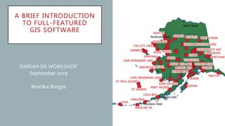
- 1. A BRIEF INTRODUCTION TO FULL-FEATURED GIS SOFTWARE DARIAH-DE WORKSHOP September 2019 Monika Barget
- 2. FULL-FEATURED GIS SOFTWARE IMPORTANT: GIS software displays geo-data and adds refined visual features (colours, patterns, symbols), but it does not store the actual geographic information! Geo-information ingested into GIS software comes from databases and/or collections of raster data and shapesfiles collected in a file repository!
- 3. HOW GIS DATA ARE STRUCTURED AND STORED
- 4. DISPLAYING AND ADJUSTING GEODATA IN QGIS: E.G. MAP OF ANNETTE ISLAND • Annette Island or Taak'w Aan (Tlingit), part of the Gravina Islands in the Alexander Archipelago of the Pacific Ocean, Alaska, United States of America • Link to sample data: https://qgis.org/down loads/data/
- 5. GETTING STARTED WITH OUR HANDS-ON SESSION • IEG Digital Historial Research on GITHUB: https://github.com/ieg-dhr/
- 6. UNDERSTANDING OUR SAMPLE DATA • Samples: all files relating to the German Pietist community in Russia • Data were first stored in .TXT format and converted to different .CSV files later • Introductions to Geobrowser and Palladio are provided in German and English („Using …“ PPTs)