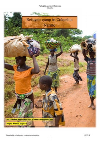
1. Refugee camp in Colombia
Nariño
Refugee camp in Colombia
Nariño
SUSTAINABLE INFRASTRUCTURE IN DEVELOPING COUNTRIES
Sergio Arenas Gayoso
Sustainable infrastructure in developing countries 2011-12
1
2. Refugee camp in Colombia
Nariño
Index
1-Introduction Pag. 3
2-Nariño: overview Pag. 3
2.1-Case Pag. 5
2.2-Site location Pag. 5
2.3-Access Pag. 6
2.3.1-Zone access Pag. 6
2.3.2-Camp access Pag. 6
2.4-Area characteristics Pag. 7
2.4.1-Surroundings Pag. 7
2.4.2-Climate Pag. 7
2.4.3-Protected areas Pag. 8
2.4.4-Natural hazards Pag. 8
2.4.5-Diseases Pag. 8
2.5-Refugees arrival Pag. 8
2.6-Surface taken Pag. 9
2.7- Possible Incomes Pag. 9
3-Infrastructures Pag. 9
3.1-Taps Pag. 9
3.2-Latrines Pag. 10
3.3-Showers Pag. 11
3.4-Health centre Pag. 11
3.5-Referral hospital Pag. 11
3.6-School Pag. 11
3.7-Distribution point Pag. 12
3.8-Feeding centre Pag. 12
3.9-Reception and administration centre Pag. 12
3.10-Environmental centre Pag. 12
3.11-Orientation centre Pag. 12
3.12-Armory Pag. 12
3.13-Others Pag. 13
3.14-Refuse drums Pag. 13
3.15-Fire hazard Pag. 13
3.16-Tents Pag. 13
4-Water Pag. 16
4.1-Requirements and consumption Pag. 16
4.2-Water systems Pag. 16
4.2.1-Drinking water Pag. 16
4.2.2-Drinking water treatment Pag. 17
4.2.3-Waste water treatment Pag. 18
5-Energy Pag. 19
5.1-Energy requirements Pag. 19
5.1.1-Water distribution Pag. 19
5.1.2-Sewage treatment Pag. 19
5.1.3-Light and equipment Pag. 19
5.1.3.1-Biodigestor Pag. 19
5.2-Energy consumption Pag. 22
5.3-Power generator Pag. 22
6-Conclusion Pag. 23
7-References Pag. 23
Number of words (excluding figures/tables and references): 2992
Sustainable infrastructure in developing countries 2011-12
2
3. Refugee camp in Colombia
Nariño
1-Introduction
In this work, the design of a refugee camp suitable for accommodating 12000 people, is
presented. These refugees are fleeing from the FARC and ELN guerrillas in Nariño
(Colombia). The design conforms to the requirements for Refugee Camps of the “UNHCR
Handbook for Emergencies”.
A dimensioned drawing of the camp, showing where residences and other buildings are
placed as well as the position of paths, roads and the water pipe network, is shown.
Furthermore, a complete explanation for all the design decisions, considering the water
treatment system and the energy supply system, is included.
2-Nariño: overview
Colombia has one of the largest displaced populations in the world. Involuntary displacement
is estimated at 2.9 million persons (USCR, 2006; AI, 2008).
Nariño Department, in the southwest of Colombia, has
an extension of 33268km2 and has 64 Municipalities,
including its capital, Pasto. It limits the north with the
Department of Cauca, on the east with Putumayo,
South to Ecuador and West by the Pacific Ocean.
Figure 1. Nariño location in Colombia
According to the CODHES (2006a), the increase of the confrontation armed Nariño is due, in
part, to the transfer of illegal crops to this department since they were before in Caquetá and
Putumayo. According to figures from the Observatory human rights and the International
Humanitarian Law (DDHH and DIH), in 2006 the terrorist acts in Nariño rose by 100%. This
is one of the worst crisis of forced displacement and disappearances in the world, which has
led to Colombia to be considered as one of the most violent countries in the world (rank
139/153) (GPI, 2011).
Sustainable infrastructure in developing countries 2011-12
3
4. Refugee camp in Colombia
Nariño
According to reports from the UN's refugee agency in 2008 (UNHCR), there was forced
recruitment of minors.
La Tola
Pacific Ocean
Tumaco
Bay
Barbacoas
Telembí River
Figure 2.
Nariño map
Refugee Camp
The paramilitary groups continue operating and insisting on their actions against civilians;
both guerrillas FARC and ELN do not compliance the principles of international humanitarian
law, which contributes to these forced migrations in Nariño (CODHES, 2006b).
There is an area with around 10000 and 15000 people at risk along the Tapajos River zone,
in addition to the 1485 families (approx. 7200 people) which have been shifting since 2007
(OCHA, 2007).
Sustainable infrastructure in developing countries 2011-12
4
5. Refugee camp in Colombia
Nariño
2.1-Case
For the case of study, 2500 families (about 12000 people, 4-5 people/family) had to escape
from La Tola since the FARC have been kidnapping children and extorting families for
several months. They decided to settle down 7 km west of the city of Barbacoas.
2.2-Site location
The particular site is located 7km west of the town of Barbacoas, 13km from the village of
Cocoa in the municipality of Roberto Payán and approximately 40km from Ecuador border.
Figures 3 to 5. 3-refugee camp location in Nariño (3 cm = 25 km); 4-refugee location. Contours
and rivers map (3 cm = 10 km); 5- location site in detail (3 cm = 5 km).
3
Refugee camp location
Refugee camp
location. 4
There is a 3%
slope which
makes it easier
the natural
drainage
Sustainable infrastructure in developing countries 2011-12
5
6. Refugee camp in Colombia
Nariño
5
Refugee camp location
Therefore, they could be helped by nearby towns and also be accepted by the neighboring
country with which they are traditionally united by commercial, social and family interests.
The Coordinates are:
Latitude: 1.67015
Longitude: -78.224
2.3-Access
2.3.1-Zone access
To access the area there are different alternatives. Access by road can be done from Pasto
(Pasto - Tumaco) to Junín (180km). From there, it should be taken the secondary road
(10km) and finally, there are 45km of unpaved road.
Access from another location can be done either with vehicles suitable for unpaved roads
and by rivers.
2.3.2-Camp access
Access to the camp can be made by 5 points
1. There is a walking path that connects with barbecues. Upgrading works are made to
allow passing of vehicles.
2. There is a road that ends in an area of open ground, 100m from the camp. This road
connects with the Municipality of Roberto Payán.
Sustainable infrastructure in developing countries 2011-12
6
7. Refugee camp in Colombia
Nariño
3. There is a 1.5km route as an access for vehicles in the southwest, communicating
with a road towards the city of Cacao.
4. The banks of the river have enough width for the circulation of small vehicles,
especially two-wheelers.
5. It can be accessed directly from the river Telembí.
2.4-Area characteristics
2.4.1-Surroundings
Being the camp situated 300m from the banks of the Rio Telembí, topography is suitable for
settlement, since the 3% slope, from camp to the river, allows natural drainage.
A safe distance from the river will be kept as heavy rains can cause overflow since this river
has pretty river flow throughout the year (510.8m3/s) (Uscátegui, 1993). In fact, there is no
need neither use nor store rainwater.
Forests are very representative and have invaluable natural value, since 40% of the total
area is covered by this type of vegetation. Besides providing shade, are a good source of
raw materials and natural food. On the other hand, they help to fight against high
temperatures.
The western Telembí river basin has the greatest forest cover. The exploitation of natural
forests is not for commercial purposes, but for supplying local communities in the area
(Santacruz-Nariño Government, 2011).
2.4.2-Climate
Since the weather is typical of the region in terms of rainfall and temperatures are
concerned, the refugees have no problem with that.
As shown both in the charts and table 1, the climate is mild throughout the year.
Figure 6. Max and min temperatures (Pasto’s observatory)
30
25
20
15 T max
T min
10
5
0
J F M A My J Jl Ag S O N D
a o
T is in C ; data taken from www.allmetsat.com
Sustainable infrastructure in developing countries 2011-12
7
8. Refugee camp in Colombia
Nariño
Figure 7. Annual precipitation (Pasto’s observatory)
200
180
160
140
120
100
Precipitation (mm)
80
60
40
20
0
J F M A My J Jl Ag S O N D
Data taken from www.allmetsat.com
Table 1. Annual average climate data
Data Value
Annual average temperature (Co) 13.9
Annual average maximum temperature (Co) 20.4
Annual average minimum temperature (Co) 9.1
Annual average humidity (%) 79.9
Annual average wind speed (km/h) 9
Data taken from www.tutiempo.net
The biggest problem comes with the rain season because, although the soil allows good
drainage and is a good absorbent, it cannot be avoided the formation of clay and mud.
2.4.3-Protected areas
There is not any protected area in the zone. The closest point is the Sanquianga National
Park in the Municipality of Mosquera (over 200km away to the North).
2.4.4-Natural hazards
An earthquake, with magnitude 7.9, was reported on December 12th in 1979 in the
Department of Nariño in Tumaco (SGC, 2011).
2.4.5-Diseases
P. falciparum is the main cause of malaria which is the main cause of death by disease in
Colombia. There is an annual average of 130000 to 150000 cases of malaria (Padilla
Rodríguez, 1998).
2.5-Refugees arrival
Most refugees have arrived on foot, jeeps and boats from La Tola, following the course of
the Patía River and taking the river Telembí, one of the tributaries of Patía River.
Sustainable infrastructure in developing countries 2011-12
8
9. Refugee camp in Colombia
Nariño
2.6-Surface taken
A 48ha area has been taken, which implies about 40m2 per capita (around 12000 people).
Since the camp is expected to endure for at least a year or two, with a growth rate of 3%, the
surface could be reduced to 37m2 per inhabitant. However, since the land in that area may
belong to the state, are the nearby local urban districts the responsible of the land in case of
surface required.
2.7- Possible Incomes
There are two vegetable gardens but they provide food only for the camp. However, the
community contains pottery and sewing workshops, so they could use the handicrafts as
objects of exchange (kerosene) or sale.
3-Infrastructures
From now on, the structure will be based on UNHCR (1999). For further understanding, see
figure 9.
The refugee camp is composed of 12000 people (2500 families).
The gender and age distribution are shown in table 2:
Table 2. Gender and age distribution
Gender
Age Men Women
0-10 5% (600) 7% (840)
11-18a 12% (1440) 18% (2160)
19-40 14% (1680) 11% (1320)
41-60 7% (840) 6% (720)
≥61 8% (960) 12% (1440)
46% (5520) 54% (6480)
TOTAL
12000
a
Age of majority
3.1-Taps
150 (1/80 people).
There are two water tanks for the residential area located among the tents (better access).
96000l/d have been estimated, therefore, each has a 60000l capacity. The measures are
shown in table3:
Table 3. Standard measures for water tanks
Water tank
Height (m) 3
Diameter (m) 5
Number of taps/tank 75
Sustainable infrastructure in developing countries 2011-12
9
10. Refugee camp in Colombia
Nariño
3.2-Latrines
1362 (1/8-9 people). Number and distribution are shown in table 4.
Table 4. Number and distribution of latrines
Latrines zone
Nº latrines/men 552 (1/10)
Nº latrines/women 810 (1/8)
Nº latrines/disabled men (4%)a 23
Nº latrines/disabled women (3%)a 26
School
Boys 4
Girls 6
Health centre (HC)
HC1 10
HC2 10
a
WHO, 2011
Placing the latrines at the end of the camp would be better in terms of odors, sanitation,
order and access. They will be behind the tents, in both sides. The women latrines are
placed on the left, as they are more protected by vegetation. On the right, are placed the
men latrines. There are no in-tent latrines, however there could be people that decide to
install independent systems in theirs tents. If the time estimated in the camp was greater, it
would be installed an in-tent latrine in every tent.
Latrines at school will be placed in the same way as the latrines zone: on the left for girls, on
the right for boys.
All the latrines in both health centres are suitable for disabled people.
Surface and placement are shown in tables 5 and 6.
Table 5. Surface of the latrines
Latrine 1x1 m = 1 m2 a
Latrines for disabled 1.5x2 m = 3 m2 a
Gap between latrines 1m
a
Standard measures portable latrines
Table 6. Placement of the latrines
Men 45x45 m = 2025 m2 a
Disabled men e 113 m2 b
Total area 2138 m2
Women 3025 m2 c
Disabled women e 128 m2 d
Total area 3153 m2
a
Square surface: √552 = 23; 23+22 m (gaps) = 45 m
b 2
23x1.5 m = 34.5 m; 34.5 + 22 m (gaps) = 56.5; 56.5x2m = 113 m
c 2
Square surface: √810 = 28; 28+27 m (gaps) = 55 m; 55x55 = 3025 m
d 2
26x1.5 m = 39 m; 39 + 25 m (gaps) = 64; 64x2m = 128 m
e
Placed in the first row, in order to make the access easier
Sustainable infrastructure in developing countries 2011-12
10
11. Refugee camp in Colombia
Nariño
3.3-Showers
240 (1/50 people). The number of showers and the surface are shown in table.
Table 7. Number of showers and surface
Showers zone
Nº showers/men 120 (1/46)a
Nº showers/women 120 (1/54)a
Shower 1.5x1.5 m = 2.25 m2 b
a
Same number for men and women
b
Standard measures portable showers
There will be two rows of 60 showers each in both women and men zones. The total area is
shown in table 8.
Table 8. Surface and placement of the shower
Men
Length 1.5x60 m = 90 m ≈ 100 m
Width 1.5x2 m = 3 m ≈ 4 m a
Total area 400 m2
Women
Length 1.5x60 m = 90 m ≈ 100 m
Width 1.5x2 m = 3 m ≈ 4 m a
Total area 400 m2
a
2 rows
The showers are placed about 200-300m from the river, in order to minimize the pumps
power (located in the bank of the river).
3.4-Health centre
There will be two health centres at both sides of the camp (1/6000 people). Both will help
with minor injuries and bruises as well as providing medicines in case of diseases or
infections such as cholera or malaria.
3.5-Referral hospital
The two referral hospitals are located well away from the area. But above all, they are
affected by poor communications in the region.
The closest hospital is the San Andres Hospital in Tumaco, 160km-5h by car.
3.6-School
Currently, the camp has 5040 children aged from 0 to 18 years. It will be divided into two
shifts: morning, children 5-13 years old and in the afternoon, children from 14 to 18.
Therefore, the school will be sized for 2000 children.
Sustainable infrastructure in developing countries 2011-12
11
12. Refugee camp in Colombia
Nariño
The school, for safety, is placed in the middle of the refugee camp because the control and
protection is greater, since children are the most affected by the guerrillas.
3.7-Distribution point
There will be three distribution points, one for each vehicle access. The West distribution
point is located 50m from the piece of open ground. They will receive basically food and
some other things.
3.8-Feeding centre
There will be two feeding centres. Each center will be located 50-100m from the west and
southwest distribution points, in order to facilitate the distribution food to the kitchen.
However, many people are used to cooking outside the tent.
3.9-Reception and administration centre
It will be located in the South of the camp.
It will be responsible for the reception of new arrivals as well as bureaucratic and economic
issues. It will also coordinate the rest of the management centers. Besides, it will be
responsible for the maintenance and cleanliness of latrines, showers (every 3 days) and
maintenance of the power generator.
3.10-Environmental centre
It will be located in the South of the camp.
It will responsible of the sustainable use of the raw material as well as the cleanliness of the
refugee camp (waste and rubbish). It also will control the water treatment processes, the
biogas plant and the vegetable gardens.
3.11-Orientation centre
It will be located in the South of the camp. It could be formed of 2-3 tents.
It will be responsible for psychology orientation as well as supporting for women who suffer
gender violence.
It also could hold some courses like pottery, sewing or painting.
3.12-Armory
It will be located in the South of the camp and in every access point in order to receive
weapons from the nearby communities or the Army. It could be formed of 3-4 tents
It will be basically a center where weapons and arms for defending from armed groups. It will
be responsible for the security of the camp. It will manage the train of volunteer soldiers and
the tactics and strategies for the camp safety.
Sustainable infrastructure in developing countries 2011-12
12
13. Refugee camp in Colombia
Nariño
3.13-Others
There will be also a church (a tent turned into it), a cemetery, a sport area (where kids can
play some sports), and a couple of vegetable gardens (for the camp use). Al, of them will be
surrounding the camp
3.14-Refuse drums
129 (1/93 people).
30 located along the latrine zone (30 on the right in the women latrine zone and 30 on the
left in the men latrine zone), due to odor reasons. Furthermore, it has been decided not to
place many any of them around the tent zone, as it could end up by polluting this area and
therefore it may develop some diseases.
15 in each feeding centre (30 in total).
10 located in the tent area.
29 distributed along the camp:
2 in every access point (2x5 = 10)
1 in the health centre (x2)
1 in the school
1 in the reception and administration centre
1 in the church
1 in the environment centre
1 in the area of open ground
2 in the sport area
3 in the orientation centre
2 in the vegetable gardens
1 in the cemetery
4 in the armory
3.15-Fire hazard
In the event of fire, there will be two mainly meeting points: the area of open ground (west of
the camp) and the sport area (east of the camp). People could go to the river as well (north
of the camp).
3.16-Tents
900 tents (3.7m2/person).
2 familys/tent. However, each tent has the ability to split into two with a cloth in the middle in
order to make it easier the family independence. The tent measures and total area of the
camp module are shown in table 9.
All of them are will be facing south, to maximize sunlight (E-W).
Sustainable infrastructure in developing countries 2011-12
13
14. Refugee camp in Colombia
Nariño
Table 9. Tents, blocks and camp module surface
Tents
Measure 6.1x6.1 m = 37.21m2
Blocks
Number of blocks 5
Tents/block 180 a
People/block 1440-1800
Block measure
Width 103.4 m b
Length 105.3 m c
Surface/block 1.1 ha
Gap among blocks 100 m
Gap among blocks: between rows 100 m
Camp module
Length 510 m d
Width 311 m e
Total surface ≈ 16 ha
a
13 tents lengthwise x 13 tents widthwise = 169 tents; a first row of 11 tents in front of each module
b
13x6.1 = 79.3 m; gap among tents = 2 m (12 gaps); 79.3+24 = 103.4 m
c
79.3+24 = 103.4; 2 m gap with the first row → 105.3 m
d
103.4x3 blocks = 310.2; 2x100 m gaps
e
105.3x2 blocks = 210.6; 1x100 m gap
The tents have been provided by ACNUR. There is currently a branch in Pasto on behalf of
ACNUR. It basically helps with legal and social aid.
The tents are made of blue plastic, 1.8m high, with capacity for 8-10 people (two families),
rear and front door, both with nylon zippers and buttons, windows and doors with mosquito
nets.
A 40cm width and 30cm height channel
could be made around every tent to prevent
flooding and minimize the formation of clay
and mud. It may be made a small network
so that, thanks to the slope, it could drain to
the river (fig. 8).
Figure 8. Channel to avoid flooding.
Own elaboration
Sustainable infrastructure in developing countries 2011-12
14
15. Refugee camp in Colombia
Nariño
Figure 9. Refugee camp map
. .. .
. .. .. .....
.. .. .
.. .. .
.
. . .. .. . .
. .
. . .
.
.. .. .
.
.
. .
. ..
. ..
.
.
. .
.. . . .
A
.
.
.
.
. .
.. . . . .
. . . .
A
.
.
. ..
. ..
. . . . .. . .
. .. ... .
. R .
. . .
. .
. .
.
O
. .. .
E
. . .
O
.
A O
. ..
. . .
.
..
. A ..
..
Water pipe network Key to map symbols
Showers
Livestock
Disabled latrines
Trees
Roads/paths
Area of
River
open ground
Biodigestor
Latrines
Armory
Block
Reception
Distribution centre administration
centre
500 m Feeding centre Environmental
Health centre centre
Orientation
School
centre
Sport area Refuse drums
Church Post lamp
Septic tank
Own elaboration Vegetable garden
Reservoir tank
Power generator
Filter tank
Cemetery Drinking water
tank
Sustainable infrastructure in developing countries 2011-12
15
16. Refugee camp in Colombia
Nariño
4-Water
4.1-Requirements and consumption
For water requirements will be followed the guideline of UNHCR (1992). The following table
shows the average water requirements.
Table 10. Average water requirements.
Latrines 6810 l/d a
Latrines school 50 l/d a
Showers 240000 l/d b
Drinking water 96000 l/d c
Medical services 18000 l/d d
Feeding centres 96000 l/d e
Total 460000 l/d
a
5 l/d latrine x 1362 latrines; 10 latrines in the school
b
20 l/d person x 12000 people
c
8 l/d person x 12000 people
d
3% of the population (360 people) goes to medical services/d → 50 l/d x 360 people
e
40% of the population (4800) goes to feeding centres/d → 20 l/d x 4800 people
4.2-Water systems
4.2.1-Drinking water
A requirement of 96000l/d has been estimated, therefore, each has a 60000l capacity
(standard measures presented in table 11).
Table 11. Standard measures for water tanks
No water tanks 2
Height (m) 3
Diameter (m) 5
No of taps/tank 75
They will be placed among the tents.
There will be two tanks beside for feeding and medical centres and the school.
First one will supply 2 feeding centre and one health centre. The other one will supply the
requirements of the school and the other health centre on the other side of the camp.
Both of them will have a 60m3 capacity.
The water tanks are distributed for all over the camp so in the event of a fire, they would be
used as a source of water.
Sustainable infrastructure in developing countries 2011-12
16
17. Refugee camp in Colombia
Nariño
4.2.2-Drinking water treatment
For water tanks, there will be a pre-treatment of water. It will be composed of the following
items as being simple and cheap, though not so fast.
1. Water reservoir (100000l capacity): water comes directly from the river (through
water pumps). It remains there for 12-24h. It could be applied flocculation-
coagulation system just in case of necessity as it could be needed another tank with
the same size and the Aluminum sulphate is expensive. The sedimentation process
would be carried out in this tank.
2. Filtration tank: it will be used a rapid gravity sand filter as a pre-treatment is needed.
Besides, the high demand of water urges as less time as possible.
3. 2 water tanks (60000l each), where the disinfection is carried out (It would be needed
bleaching powder).
Figure 10. Drinking water treatment. A plan view is also shown
Flocculation-coagulation
From the river
Own elaboration
Sustainable infrastructure in developing countries 2011-12
17
18. Refugee camp in Colombia
Nariño
4.2.3-Waste water treatment
There will be septic tanks as it is believed to be the most feasible way in this case for
treating the sewage, as the ground could not cope or absorb the overflow.
As the needs for both showers and toilets, are in total 123000l, there will be four 35m3 septic
tanks on each showers-latrines zone. They are designed to receive wastewater discharges
and to provide water free of debris.
There will be two 35m3 septic tank for the feeding centres and one the health centre as well
as for the school and the other health centre. The figure 11, shows the septic tank scheme.
The water is either returned to the river by pipeline, or used to irrigate the vegetable
gardens.
Figure 11. Waste water treatment. Septic tank
5m
Inspection (Pump Out) Ports
4m
Inlet: sewage enters from
shower/latrine zone
Own elaboration
Sustainable infrastructure in developing countries 2011-12
18
19. Refugee camp in Colombia
Nariño
5-Energy
5.1-Energy requirements
5.1.1-Water distribution
The following table shows the energy requirements for water distribution.
Table12. Energy requirements for water distribution
Pump from the river (Q=460000;H=30) 1.5 kW/d a
Showers-latrines zone (Q=125000; H=15) 0.21 kw/d
Drinking water (Q=48000;H=20) 0.11 kw/d
Tanks for feeding centres, 0.4 kw/d
medical centres and the school (Q=114050;H=30)
Total b 2.54 kw/d
a
Equation for calculating (axial) pump power: P(W)=[(ρgQH)/24/3600/1000] (University teacher personal
3 2
communication, 16/03/09); where ρ: water density (1000 kg/m ), g: gravity (9.8 m/s ), Q (l/d): flow required, H
(m): height required to elevate the flow from the source to the consumption point and considering a 3% slope.
Energy losses are no considered.
b
Considering 2 showers-latrines zones and 2 drinking water tanks
5.1.2-Sewage treatment
The following table shows the energy sewage treatment requirements.
Table 13. Energy requirements for sewage treatment
Septic tanks for shower-latrine zone (Q=30000;H=2) 0.07 kw/d
Septic tanks for feeding centres, medical centres and the school 0.25 kw/d
(Q=114000;H=2)
Total a 0.81 kw/d
a
Considering eight septic tanks for shower-latrine zone in total
5.1.3-Light and equipment
5.1.3.1-Biodigestor
A biodigestion plant has been suggested as being the most environmental solution in this
case due to the presence of livestock. Other solution would be so expensive.
The conditions are presented in table 14.
Sustainable infrastructure in developing countries 2011-12
19
20. Refugee camp in Colombia
Nariño
Table 14. Biodigestor conditions
Livestock 90 a
Head of cattle 50
Goats 40
Cattle excrement 4 kg/d b
Cattle excrement outcome 0.036 m3 biogas/kg b
Goats excrement 1.5 kg/d b
Goats excrement outcome 0.054 m3 biogas/kg b
Biogas/cattle 7.2 m3
Biogas/goat 3.24 m3
Total biogas/d 10.5 m3
Methane outcome 10 kwh/m3 b
Obtained energy 100 kwh/d
Light bulb power/tent 10 W
Camp module consumption energy (light) 54 kwh/d c
a
Extensive conditions, besides they drink directly from the river
b
Ramachandra et al, 2000
c
10 Wx6 h/d = 60 Wh/d tent; 900 tents x 60 Wh/d = 54 kwh/d
The biodigestor could supply enough energy to light all the tents in the camp as well as the
rest of the centres. However, the camp relies on a power generator as more than two weeks
of retention time is required so it may not be gas production for some days (Filippín et al,
1999). A scheme is presented below (fig. 12).
Surplus excrements may be used to fertilize the vegetable gardens. Ashes from biomass
combustion could also be used to fertilize them.
The location of the biodigestor will be close to the livestock and near the gas consumption
points. It will be protected from prevailing winds (Filippín et al, 1999).
However, the following table shows the light infrastructure as well as basic equipment
necessary in the refugee camp.
Sustainable infrastructure in developing countries 2011-12
20
21. Refugee camp in Colombia
Nariño
Table 15. Light infrastructure in the refugee camp
Lamp posts distributed in the camp a Number
Showers-latrines zone (2 zones) 20
Tents zone 11
Health centre (x2) 4
School 2
Reception and administration centre 2
Church 2
Environment centre 2
Area open ground 2
Sport area 2
Orientation centre (x3) 6
Vegetable gardens (x2) 4
Cemetery 2
Armory (x4) 8
Access to the camp (without considering river access) (x3) 6
Surrounding the camp 10
Total 83
Energy required 2.5 kw/d
a
2.5m height and 30 W power
Table 16. Basic equipment in the refugee camp
Equipment Number
PC’s (80 W/PC) 4
Fridges (to store food) (150 W/fridge) 4
Medical equipment 10
Figure 12. Biodigestor scheme
Vegetable gardens
Excrements Inlet
3m
4m
Biodigestor
Own elaboration
Sustainable infrastructure in developing countries 2011-12
21
22. Refugee camp in Colombia
Nariño
5.2-Energy consumption
The diary energy consumption in the camp is shown in table 17.
Table 17. Diary energy consumption
Water pumps: 3 h/d 7.6 kwh/d
Water treatment: 3 h/d 0.25 kwh/d
Lamp posts: 6 h/d 15 kwh/d
PC’s 1.3 kwh/d
Fridges 1.6 kwh/d
Medical equipment 1.4 kwh/d
Boilers (2x300 kw)a 1 Mwh/d
Total 1.03 Mwh/d
a
Boilers are for hot water in the showers. There is no need of heating considering the high
temperatures throughout the year. ACNUR could supply blankets if necessary.
A 1300kVA power generator will be installed with a 0.8 power factor (standard measures). It
is the best solution in case there is not access to the grid. Besides, it is more reliable over
other energy sources.
It will be placed in the South area in order to avoid the noise problems it may cause.
Figure 13. Power generator scheme
Own elaboration
Sustainable infrastructure in developing countries 2011-12
22
23. Refugee camp in Colombia
Nariño
6-Conclusion
In this work, a refugee camp design has been presented. The camp has been placed in
Nariño (Colombia). 12000 people from La Tola, displaced to the south as they were afraid of
the presence of FARC and ELN guerrillas. The area where de camp has been settled has
rich biodiversity of both flora and fauna and has a river which could be used as a water
source. Furthermore, nearby communities could help the refugees by supplying either
kerosene or required goods. Besides, refugees could escape to Ecuador as they have been
traditionally united by commerce and culture for many years.
For the camp design, basic elements and infrastructures have been considered under the
UNHCR guidelines for emergencies.
Regarding drinking water treatment, four tanks have been suggested in which
sedimentation, filtration and chlorination processes are carried out. They are placed in the
camp module.
Regarding wastewater treatment, septic tanks have been suggested. Treated wastewater
could go either river or vegetable gardens.
For the energy system, a biodigestor has been suggested. It could supply enough energy to
light every tent. However, a power generator is required in order to supply energy for the rest
of electric infrastructure.
7-References
Amnesty International, 2008. Leave us in peace “targeting civilians in Colombia’s internal armed
conflict”. Amnesty International Publications.
CODHES, 2006a. Colombia: Informes especiales: Nariño, Putumayo y Panamá. Consultoría para los
Derechos Humanos y el Desplazamiento. Available at: <http://www.reliefweb.int/rw/RWB.NSF/
db900SID/ACIO-6NDC7J?Open Document> [Accessed 26 October 2011].
CODHES, 2006b. Política publica de atención al desplazamiento forzado en el departamento de
Nariño. Consultoría para los Derechos Humanos y el Desplazamiento. Available through CODHES
website<http://www.codhes.org/index2.php?option=com_docman&task=doc_view&gid=141&Itemid=5
1> [Accessed 24 October 2011].
CODHES, 2008. Consultaría para los derechos humanos y el desplazamiento. Los desplazados.
Documentos. Available at:
http://www.codhes.org/index.php?option=com_docman&task=cat_view&gid=55&Itemid=51 [Accessed
12 November 2011].
DDHH and DIH, 2006. Situación de Derechos Humanos y Derecho Internacional Humanitario.
Available through: Programa presidencial de Derechos Humanos y Derecho Internacional
Humanitario website < http://www.derechoshumanos.gov.co/Paginas/DDHH.aspx> [Accessed 13
November 2011]
Filippín, C., Follari, J., Vigil, J., 1999. Diseño de un biodigestor para obtener gas metano y
fertilizantes a partir de la fermentación de excrementos de vacas lecheras en la facultad de
agronomía de la universidad nacional de la pampa. Available at:
http://www.cedecap.org.pe/uploads/biblioteca/28bib_arch.pdf [Accessed 20 November 2011].
Sustainable infrastructure in developing countries 2011-12
23
24. Refugee camp in Colombia
Nariño
GPI, 2011. Institute for economics & peace. Methodology, results & findings. Available at:
<http://www.visionofhumanity.org/gpi-data/#/2011/scor> [Accessed 20 November 2011].
Ibáñez, A. M., Vélez, C. E. 2008. Civil Conflict and Forced Migration: The Micro Determinants and
Welfare Losses of Displacement in Colombia World Development, Volume 36, Issue 4, pp. 659-676.
OCHA, 2007. Ficha técnica - situación humanitaria departamento de Nariño. Sala de situación
humanitaria. Available at: < http://www.colombiassh.org/site/IMG/pdf/FT__Narino_20.08.07.pdf>
[Accessed 24 October 2011]
Padilla Rodríguez, J.C., 1998. Tratamiento de la malaria en Colombia. Programa de Riesgos
Biológicos de la Subdirección de Ambiente y Salud. Volume 2.
Ramachandra, T.V., Joshi, N.V., Subramanian, D.K., 2000. Present and prospective role of bioenergy
in regional energy system. Renewable and Sustainable Energy Reviews, Volume 4, Issue 4, pp. 375-
430.
Santacruz-Nariño Government, 2011. La Ecología en el municipio de Santacruz/Guachavez.
Available at:
http://santacruz-narino.gov.co/nuestromunicipio.shtml?apc=mfxx1-&m=d#Medio Ambiente [Accessed
31 October 2011].
rd
SGC, 2011. Calendar of events. Quake on 23 of November of 1979. Available at:
http://seisan.ingeominas.gov.co/RSNC/index.php?option=com_jevents&task=icalrepeat.detail&evid=7
1&Itemid=0&year=2011&month=11&day=23&uid=c35d3ee47a69fcd1fad2eb99a391d1c0 [Accessed
20 November 2011].
UNHCR, 1992. Water manual for refugee situations. Pp. 27-45.
UNHCR, 1999. UNHCR Handbook for Emergencies. Second Edition, pp. 132-147.
UNICEF, 2002. Sembrando Minas, Cosechando Muertes. Colombia y las minas Antipersonal. Diana
Roa. Ministerio de Comunicaciones, Embajada de Canadá y UNICEF Colombia.
Uscátegui, A., L-G., 1993. Hidrología e Hidrogeología de la Región Pacífica Colombiana. Fondo para
la Protección del Medio Ambiente “José Celestino Mutis”, FEN Colombia, Bogotá Colombia-Pacífico:
Leyva, P.Volume I, pp 122-134.
USCR, 2006. World refugee survey 2006. Washington.
WHO, 2011. World report on disability. Available at:
http://www.who.int/disabilities/world_report/2011/report/en/index.html>
[Accessed 19 November 2011].
Sustainable infrastructure in developing countries 2011-12
24