Basic Civil Engineering first year Notes- Chapter 4 Building.pptx
What is gis
1. Geographic Information Systems
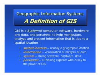
Geographic Information Systems
GIS is a System of computer software, hardware
and data, and personnel to help manipulate,
analyze and present information that is tied to a
spatial location –
• spatial location – usually a geographic location
• information – visualization of analysis of data
• system – linking software, hardware, data
• personnel – a thinking explorer who is key to
the power of GIS
2. What is GIS?
• There are probably as many definitions of GIS as there are
authors on GIS but there are certain fundamental
components that remain the same throughout:
1. Geographic locations also called geographically
referenced or spatial data
2. Information about the locations also called Attributes or
Non-Spatial data
3. Software for storing and processing the data
4. Hardware to facilitate the storage, processing and
distribution of data
5. The people who operate the systems
3. GIS Definitions
• An organized collection of computer hardware, software, geographic
data and personnel designed to efficiently capture, store, update,
manipulate, analyze and display all forms of geographically
referenced information.
• In summary, Demers describes GIS as consisting of 4 sub-systems
1. A Data Input subsystem that collects and preprocesses spatial data
2. A data storage and retrieval subsystem that organizes the spatial data
3. A data manipulation and analysis subsystem that performs tasks on
the data
4. A reporting subsystem that displays the data in tabular, graphic or
map form.
4. • A method to
visualize, manipulate,
analyze, and display
spatial data
• “Smart Maps”
linking a database to
the map
5. • GPS – Global Positioning System
• A static map – paper or digital
– Maps are often a “product” of a GIS
– A way to visualize the analysis
• A software package
6. History
• Pre-computer
– Early maps
• CGIS
• Harvard
• No books till around 1990 (Star & Estes) that dealt with
GIS by computer
• Theory books
– Burroughs
– Ian McHarg’s
History of CAD Graphics
7. Contributing Sciences
• Geography - generally concerned with man and his environment.
• Cartography - for the display of spatial information in the form of
maps. Maps are graphic representations of the real world.
• Computer Science - Provides the hardware, software and techniques
for accomplishing the essential functions of a GIS
• Surveying and Photogrammetry - Provides the geographic locations
• Remote Sensing - A source of data from satellite images and aerial
photography
• Global Positioning System (GPS) - A source of highly accurate
locational data and navigation tool.
• Database Technology - Handles large volumes of data in tabular
form, making it easy to store, access and manipulate data.
• Mathematics - The use of geometry, statistics are integrated in a GIS
• CAD (Computer Aided Design) - A tool for accurately designing
maps digitally.
8. How does a GIS differ from CAD or
Database Systems
1. The ability to construct topology in a GIS and therefore to
perform complex spatial analysis
2. The ability to link the traditional cartographic-type of map
to a database and perform complex queries, interacting
with both.
9. What is it used for?
1. Can you map that?
2. Where is what?
3. Where has it changed?
4. What relationships exist?
5. Where is it best?
6. What affects what?
7. What if...?
10. • Estimates are that 80% of all
data has a spatial component
– Data from most sciences can be
analyzed “spatially”
11. Database
Database
“Not Easy to Interpret”
“Not Easy to Interpret”
12. Visualization
Visualization
“Worth a Thousand Words”
“Worth a Thousand Words”
13. Two Ways to Input and Visualize Data
Two Ways to Input and Visualize Data
The World in GIS
The World in GIS
• Raster – Grid
– “pixels”
– a location and value
– Satellite images and aerial
photos are already in this
format
Real world • Vector – Linear
– Points, lines & polygons
– “Features” (house, lake, etc.)
– Attributes
– size, type, length, etc.
14.
15. • Digitized and Scanned Maps
– purchased, donated, free (Internet)
– created by user
• Data Bases – Tables of data
• GPS – Global Positioning System
– accurate locations
• Field Sampling of Attributes
• Remote Sensing &
Aerial Photography
16. Five Data Layers
Five Data Layers
“Alike” Features
“Alike” Features
Rivers Capitals
Roads States
Lakes
17. Turning Data Into Information
Turning Data Into Information
“Spatial Analysis” – not just a map