
Recommended
More Related Content
What's hot
What's hot (20)
Viewers also liked
Viewers also liked (20)
Similar to Transit Oriented Development in India: Planning paradigm change at all scales
Similar to Transit Oriented Development in India: Planning paradigm change at all scales (20)
More from Uttipec Dda
More from Uttipec Dda (6)
Recently uploaded
Recently uploaded (20)
Transit Oriented Development in India: Planning paradigm change at all scales
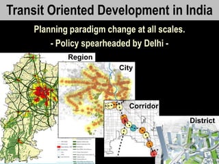
- 1. UTTIPEC Transit Oriented Development in India Planning paradigm change at all scales. - Policy spearheaded by Delhi - Region City Corridor District
- 2. UTTIPEC Why is TOD needed in Delhi/ other cities now? Issue: • Cause: Usability of MTRS: Metro has been constructed but people don‟t feel comfortable/ safe using it. Lack of safety for Women is biggest deterrent to public transport success. • Lack of last mile connectivity by bus, cycle/ walk. • Unsafe streets, due to lack of „eyes of strret‟ •,unwalkable streets. • planned paratransit facilities, • safe crossings and multimodal interchange. Auto-centric sprawl type planning has created a private vehicle dependent city, very difficult for Public Transport users. • segregated landuses, • large unwalkable block sizes, • large R/Ws with unusable footpaths, • rampant construction of flyovers and cloverleafs within city limits, leading to rupture of neighbourhoods & connectivity, • People-unfriendly urban design Delhi is already at the second highest level of air pollution in the world (by particulate matter). ~70% of the total air pollution of Delhi comes from vehicles. Delhi has more cars today than the total cars in other three Metros together. • Reasons for car dependency are as above. Environmental Degradation – due to rapid urbanization, unplanned exploitation of natural resources, destruction of natural water systems, and rapid expansion on agricultural land…. • Lack of dense development • Lack of adequate low-income housing • Lack of Environmental Resource documentation & planning • Lack of ownership of public spaces in the city.
- 3. UTTIPEC A paradigm shift in Planning is therefore needed…. • to make it easier, safer, faster and more convenient for people to use public transportation so that maximum number of people “have the choice” to leave their cars at home and shift to the use of public transport. • Only then can the desirable modal split of 80-20 (public- private) be achieved as envisioned in the Masterplan of Delhi 2021. Why is TOD needed in Delhi now?
- 4. UTTIPEC In accordance with the changing transportation scenario in India over the last two decades, there has been a change in the policies at, both, national level and in Delhi. a) National Urban Transport Policy – 2006, recommends: i. Integrated land use and transport policy ii. Priority to the use of public transport & non-motorized vehicles b) Master-plan for Delhi – 2021, proposes: i. MPD 2021 has given a thrust on redevelopment and redensification along 500m of MRTS corridors. It calls for a comprehensive redevelopment strategy for accommodating a large population, and strengthening of infrastructure facilities. Current Policies:
- 5. UTTIPEC Transit Oriented Development (TOD) encompasses any type of development that induces people to prefer the use of public transportation. The Guiding Principles of TOD are to: • Reduce private vehicle dependency and induce public transport use – through design, policy & enforcement measures. • Provide Public Transport access to maximum number of people – through densification and enhanced connectivity. Guiding Principles of TOD
- 6. UTTIPEC Rail/ Metro BRT Interchange Change Morphology from AutoCity vs. a Transit City 7 min walk To reduce car-dependence & increase transit use. Large Areas of City not Accessible to Trasit CURRENT TOD
- 7. CURRENT CITY PATTERN: • Population Density evenly distributed all over city. • Large Travel distances & pollution due to segregated land use and vehicular dependency. 7 Rohtak Road Delhi Corridor
- 8. • High Density Mixed Use within 10-min walk of stations. • Maximum people Live, Work & Play within 5-min walk of RAPID TRANSIT Stations • Reduced vehicular travel, reduced pollution. Impact of TOD Policy on City: 8 Rohtak Road Delhi TOD Corridor
- 9. UTTIPEC Defining the TOD catchment
- 10. UTTIPEC Defining the TOD Zone & Intense Use Zone Intense TOD Zone – 3 min walking distance TOD Zone – 10 min walking distance - Intense pedestrian/ NMT movement - Limited public parking - Highest ridership generating uses. - Transit supportive amenities. Lots within 10-min walk Walkable route 800m (10-min)
- 11. Actual Demarcation on ground (using GIS) Chhatarpur Station 11 Created by © UTTIPEC, Delhi Development Authority using GIS database of Delhi Intense TOD Zone – 3 min walking distance TOD Zone – 10 min walking distance
- 12. © UTTIPEC, Delhi Development Authority
- 13. NMT Zone area= 65512.95 Ha ( 44.1 % of Delhi*) TOD Standard Zone = 27369.22 Ha (18.45 % of Delhi* ) Intense TOD = 10279.96 Ha (6.9% of Delhi*) * Area of Delhi = 148300.0 Ha (as per MPD) TOD Influence Zones at City level
- 14. UTTIPEC Guiding Principles of TOD
- 15. UTTIPEC 1. Pedestrian & Non-Motorized Transport (NMT) Friendly Environment – All streets should have safe and pleasant walking/cycling environment, with safe at-grade crossings and climate-sensitive urban design. 2. Maximized Connectivity to Station exists through provision of a dense network of streets and shortest possible routes to stations. 3. Transit-supportive amenities & Modal Interchange like planned para-transit stands, easiest multi-modal interchange, hawker zones and convenient retail uses. 4. Equitable Distribution of Road Space – Accommodating all modes on roads with Priority to pedestrians, IPT, NMT and Public Transport. 5. Placemaking and Safety – A variety of public spaces including streets, parks and plazas designed to be safe, vibrant and programmed for a variety of uses/ activities for all ages, genders and people with disabilities. 6. Mixed-Use and High Density as possible near stations should be accommodated so that maximum number of people can live, work and entertain near station areas. A mix of residential, commercial and employment uses should be provided near all stations in contextually relevant proportions, in order to ensure round-the-clock activity, safety and vibrancy of the TOD. Every TOD must have….
- 16. UTTIPEC TOD Policy and Development Control Norms:
- 17. Detailed Norms for TOD: 2.1 Pedestrian & NMT Friendly Environment 2.2. Connectivity and Network Density 2.3. Multi-modal Interchange 2.4. Inducing Modal Shift 4A. Accessibility Guidelines For Social Infrastructure And Open Space 4B. Minimum Mixed-use Criteria 4C. Parking Policy and Norms For Travel Demand Management 2.5. Placemaking and Ensuring Safety 5A. Street Edge Regulations 5B. Active Frontage (Mixed Use Edge Condition) 5C. Minimum Ground Coverage 5D. Vending Zones 2.6. High Density, Mixed-use Mixed-income Development 6A. FAR and Density Thresholds 6B. Open Space and Social Infrastructure 6C. Minimum Housing Mix Criteria (by Unit Sizes) 6D. Non-Permissible Uses and Desirable Uses within the 300m Intense Zone 2.7. Physical Infrastructure and Resource Standards 7A. Water 7B. Energy 7C. Landscape 7D. Solid Waste 7D. Incentives for Additional Green Building Compliance http://www.uttipec.nic.in/
- 18. TOD Norms For: 2.1 Pedestrian & NMT Friendly Environment 2.2. Connectivity and Network Density 2.3. Multi-modal Interchange 2.4. Inducing Modal Shift 2.5. PlaceMaking and Ensuring Safety 2.6. High Density, Mixed-use Mixed-income Development
- 19. UTTIPEC 2.1: Pedestrian & NMT Friendly Environment 19
- 20. UTTIPEC Pedestrian (& Women) Friendly Environment 20 1
- 21. UTTIPEC Pedestrian (& Women) Friendly Environment 21 1
- 22. Source: SGA Architects Pedestrian & NMT Friendly Environment1
- 23. UTTIPEC BICYCLE 4% CAR/TAXI 9% 2W 14% BUS 27% METRO 3% TRAIN 1% AUTO RICKSHAW 5% CYCLE RICKSHAW 2% WALK ONLY 35% Most People in India Walk or Use Public Transport! Data Source: RITES Transport Demand Forecast Study for Dept. of Transport, GNCTD, Delhi 2010 Modal Share Delhi 2008 1
- 24. http://uttipec.nic.in/ StreetGuidelines-R1-Feb2011-UTTPEC-DDA.pdf 2.1 ALL STREETS TO BE AS PER ‘Street Design Guidelines-UTTIPEC’ Contents • Street hierarchy of Delhi • Minimum walking zone • Universal accessibility • Multi Functional Zone • Bicycle and NMT Infrastructure • Crossings • Medians, Refuge Islands • Street Lighting • Urban Utilities • Public Amenities • Traffic Calming Measure • Public Art, Street Furniture and Educative Signage
- 26. UTTIPEC 15 min Walk Bus/ MRTS Stop Current Norms encourage Large block sizes: increase walking distances, thus encouraging vehicle use. Example: A project in Noida. Image Source: Internet Connectivity & Street Network Density2
- 27. UTTIPEC 2-minute walk Finer Street Network would increase Connectivity & Provide short-cuts by foot or cycle. Modified Image Courtesy UTTIPEC DDA Connectivity & Street Network Density2
- 28. Incomplete Road Network 2.2 Connectivity Norms Vehicular Road Network @ 250m c/c Pedestrian Network @ 50-150m c/c Complete Road Network
- 29. Example: Dwarka - Existing Street Grid UNSAFEfortheseUsers © UTTIPEC, Delhi Development Authority
- 30. Example: Dwarka - PROPOSED Retrofitted Street Grid © UTTIPEC, Delhi Development Authority
- 31. UTTIPEC 2.3: Norms for Multi-Modal Interchange 31
- 32. Location & Priority of private Parking defines TOD 3 TOD: • Walkability and Mixed Use eg: Dadar Station, Mumbai TAD: • Auto-oriented; • Fractures Access to Station e.g. Janakpuri West Station, Delhi Transit Oriented Development Transit “Adjacent” Development in not TOD
- 33. 33 Pedestrian is highest priority 2.2 Station Area Planning to follow following Standards
- 34. 2.2 Make transferring between modes easy, comfortable. Source: Storm Water Guidelines, OASIS Design INC. IPT ParkingShuttle Service Pedestrian-Walkway Private Car Pick Up/Drop off Bus Stop
- 35. UTTIPEC Multi-modal Interchange Example: Chhatarpur Station Current Proposed 35 3
- 36. UTTIPEC 2.4: Norms for Inducing Modal Shift 36
- 37. UTTIPEC Majority Road Space given to private vehicles 37 4a
- 38. UTTIPEC© UTTIPEC 38 Equitable Distribution of Road Space4a FOOTPATH CYCLE-TRACK PARKING
- 39. Mixed-Use provides : Safety, Vibrancy, Reduced Travel Demand © UTTIPEC, Delhi Development Authority © UTTIPEC, Delhi Development Authority 4b
- 40. 2.4 Norms for Mixed-Use TOD Mixed Use Zone 30% Small Residential Units 20% Commercial/ Civic Any Use • Market-friendly TOD Policy – sets minimum benchmarks, and allows the market to decide what should be built in TOD zone. • So a developer of a particular site can decide whether to build apartments, shops or offices, as long as the developer adheres to these minimum development norms: • At least 30% residential and 20% Commercial/ Institutional use of FAR is mandatory in every project within TOD Zone
- 41. UTTIPEC 2.5: Norms for Placemaking & Safety 41
- 42. UTTIPEC Unsafe, inaccessible Open Spaces 42 5a
- 43. UTTIPEC Placemaking & Safety ● Open Spaces are looked upon/ watched by Surroundings ● Shared round-the-clock Spaces ● Easily Accessible 43 © UTTIPEC, Delhi Development Authority 5a
- 44. 2.5 Minimum Mix-use Frontage Criteria At least 50% of total street frontage of any TOD project should have an active frontage, i.e. a mix of at least two types of use, with different peak hours of activity stacked vertically, to provide round-the-clock eyes on the street. round the clock active streets
- 45. ITO Delhi - Now © UTTIPEC, Delhi Development Authority Unsafe Streets due to Setbacks & Boundary Walls5b
- 46. ITO Delhi - Future © UTTIPEC, Delhi Development Authority Placemaking & Safety through “Eyes on the Street”5b No Boundary Walls Minimal Setbacks Required Entries from footpaths Lighting ShadeNo Boundary Walls Minimal Setbacks Required Entries from footpaths Lighting Shade
- 47. 2.5 Critical Norms for PlaceMaking & Safety: Eyes on the street No Boundary Walls Minimal Setbacks Required Entries from footpaths Lighting Shade
- 48. UTTIPEC 2.6: Norms for High Density Mixed-Income Development 48
- 49. UTTIPEC 6 CURRENT: Segregated Land uses CAUSE High Traffic Generation 49 Dwarka, Delhi High Density Segregated Use Development
- 50. UTTIPEC 6 Mixed Use in TOD with High internal Trip Capture 50 © UTTIPEC, Delhi Development Authority Different types of Commercial, Civic, Residential Uses within same block High Density Mixed-Use Development
- 51. UTTIPEC 6 Mixed-Income Groups – Various Housing Options for Middle Class 51© UTTIPEC, Delhi Development Authority High Density Mixed-Income Development
- 52. Rs. 30,000- 60,000/ (~3.60- 7.20 Lakh p.a.) Above Rs. 60,000/- ~above 7.20 Lakh p.a.) EXISTING HOUSING MARKET INTERESTED IN STARTER HOME OWNERSHIP / 2 room Apts NEED FOR NIGHT SHELTERS microHomeSolutions Average Monthly Income Possible Target Product Rs. 5,000-30,000/ ~60,000- 3,60,000 p.a.) Rs. 5,000/- (~60,000 p.a.) 3. Housing budget is based on most common lending scenario for micro-mortgage: – 12% API on 15-year loan – and assumes a family spends 30% of income on housing. 1. Source: Consumer Pyramids, Centre for Monitoring Indian Economy P Ltd. 2. Monthly budget for Housing is equal to 30% of income, the global standard for affordability of housing. (Developing Affordable Housing, by Ben Hecht. 22% 55% 4.5% 18% LOOKING FOR RENTAL / 1 room Apts 75% of our Cities is Middle Class – needing a large supply of smaller size homes.
- 53. 30% 20% 10% Within the 30% minimum Housing requirement, the following mix is mandatory: ~25-40 sq.m. units ~65 sq.m. units 2.4 Norms for High Density Mixed-Income Development
- 54. 2.4 Transition in Densities: Variety in Development © UTTIPEC, Delhi Development Authority
- 55. Combined FAR-Density Minimums: No Universal Cap on FAR FAR shall be clubbed with Density Minimums, in order to ensure high-density mixed-income development. Density caps per influence Zone shall be based on overall Holding Capacity as per the MPD Zones. The minimum permissible standard for gross density for any TOD project is 250 du/ha. Gross FAR (site) Minimum permissible density (with ±10% variation) Residential dominated project (Residential FAR ≥ 50%) Predominantly non-residential (Residential FAR ≤ 30%) Under-utilization of FAR below 3.0 not permitted for new/redevelopment projects Under-utilization of FAR below 3.0 not permitted for new/redevelopment projects Y (2Y x100) du/ha (Y x100) du/ha
- 57. 2.7.1. Water
- 58. Rainwater harvesting is mandatory, irrespective of project size. On-site and off-site (roads/public spaces) rainwater must be harvested for reuse or ground water recharge, only after primary treatment. Rainwater Current practice: Stormwater recharged to ground without primary treatment. Physical Infrastructure and Resource Standards
- 59. Parking Lot SwalesLarge Canopy Trees EcoroofPervious Paving At least 80% of the rainwater falling on Site should be treated by Natural means. Physical Infrastructure and Resource Standards
- 60. MCD MCD SELF GENERATED SELF GENERATED Potable Water and Waste Water • For projects of 5000 resident population or more, on-site decentralized infrastructure systems i.e. local sewage treatment and recycling systems are mandatory, in order to meet the non-potable per capita demand (90 lpcd for domestic and 115 lpcd for non-domestic). • Potable per-capita requirement (135 lpcd for domestic and 20 lpcd for non-domestic) should be available from the Municipality or any other source other than ground water. Physical Infrastructure and Resource Standards
- 61. Potable Tank Sewage Treatment Facilities Sustainable Effluent discharge system to wetland / river Further Treatment for re-use Non- Potable Tank Potable Use • Internal taps • Showers & baths • Washing Non-Potable Use • Toilet Flushing • Cleaning/ Irrigation Combined or Separate Grey Water / Black Water Collection Rainfall DJB main S l u d g e d i s p o s a l Dual piping is mandatory irrespective of project size, to facilitate black/ grey separation & recycled water use. Physical Infrastructure and Resource Standards
- 62. 2.7.2 Energy
- 63. Buildings (and preferably also streets) should be oriented such that all habitable areas of Residential buildings are oriented to face North-South (within 15 ) direction. Energy: At Site level: Physical Infrastructure and Resource Standards
- 64. Buildings (and preferably also streets) should be oriented such that all habitable areas of Residential buildings are oriented to face North-South (within 15 ) direction. Physical Infrastructure and Resource Standards Energy: At Site level:
- 65. All dwelling units should get minimum 2-hour solar access in at least one habitable area (living room, bedroom or private open space) on the shortest winter day of Dec 21 (Winter Solstice). At Building level, the following Solar Access Regulations need to be followed: Microclimate of public streets: Narrow streets provide shading and air movement – and therefore greater comfort for pedestrians. Spacing between buildings should be enough to allow daylight access to all homes. Physical Infrastructure and Resource Standards Energy: At Site level:
- 66. All residential buildings shall be single-loaded i.e. each unit should face the exterior, in two opposite directions. No double-loaded corridor buildings are permissible in TODs. Openings shall be located suitably to allow for natural ventilation and daylighting of habitable rooms and access to open air for all rooms including toilets and kitchens. Double loaded housing Maximize Cross Ventilation for Units by appropriate design of unit plans (provide windows and openings appropriately) Single aspect housing Physical Infrastructure and Resource Standards Energy: At Site level: At Building level, the following Solar Access Regulations need to be followed:
- 67. Physical Infrastructure and Resource Standards Maximize Cross Ventilation for Units by appropriate design of unit plans (provide windows and openings appropriately)
- 68. No building floor-plate depth it to be more than 16 m Max16m Office building Physical Infrastructure and Resource Standards Energy: At Site level: At Building level, the following Solar Access Regulations need to be followed:
- 69. No “row-type” building (floor plate longer than 30 M) will be permitted to go higher than 15 metres. To utilize FAR, only towers with be permitted, in conjunction with 15m high “row-type” buildings. Physical Infrastructure and Resource Standards Energy: At Building level, the following Solar Access Regulations need to be followed:
- 70. • Tower dimensions may not exceed 30 m in any direction. • Spacing between two towers should not be less than 30M. Energy: At Building level, the following Solar Access Regulations need to be followed : Physical Infrastructure and Resource Standards
- 71. Physical Infrastructure and Resource Standards Screenshot of existing 3D GIS model of Delhi:
- 72. Physical Infrastructure and Resource Standards New buildings shall be tested for shading of surrounding residential buildings before Approval, in order to ensure that they do not hamper the minimum daylight access requirements of existing buildings.
- 73. All TOD Documents are available on the UTTIPEC Website:
Editor's Notes
- IMPROVING ACCESS TO PUBLIC TRANSIT:Improving footpaths, creating direct pedestrian connections to stations/stops, design standards for access (curb height, ramps, block size etc)REDUCE USE OF AUTOMOBILEPROVIDING ACCESSIBILITY INFRASTRUCTURE FOR MAJORITY OF RESIDENTS:The Right-of-Way should have equal emphasis on Pedestrians, Bicycle/rickshaws, Transit and Autos. The scale of the road (arterial, highway, collector etc), and the surrounding land-use/builtform should determine the preference of the mode of transportationINCREASE PERCEPTION OF EQUITY:By developing design standards and designing R-O-W to equally accommodate modes is the most immediate visual perception of equity. It shows that the government is actually sensitive to the common commuter’s needs. Design is key in improving perceptionFACILITATE MORE DEMOCRATIC DEVELOPMENT:Utilizing Public workshops at zonal/local scale for any improvement project will provide crucial feedback on what citizens desire and gives govt opportunities to educate citizens on alternatives. This will provide key element of ownership amongst communities of public infrastructurePRESERVE SOCIAL FABRIC OF COMMUNITIES:BY planning and designing for pedestrian-oriented living, existing social fabric is maintained and enhanced. The common neighborly behaviors of older delhi communities are things to be cherished and encouraged, and not demolished by building standards that only call for 16-20 story apartments where in one only knows the help that come to work.
- IMPROVING ACCESS TO PUBLIC TRANSIT:Improving footpaths, creating direct pedestrian connections to stations/stops, design standards for access (curb height, ramps, block size etc)REDUCE USE OF AUTOMOBILEPROVIDING ACCESSIBILITY INFRASTRUCTURE FOR MAJORITY OF RESIDENTS:The Right-of-Way should have equal emphasis on Pedestrians, Bicycle/rickshaws, Transit and Autos. The scale of the road (arterial, highway, collector etc), and the surrounding land-use/builtform should determine the preference of the mode of transportationINCREASE PERCEPTION OF EQUITY:By developing design standards and designing R-O-W to equally accommodate modes is the most immediate visual perception of equity. It shows that the government is actually sensitive to the common commuter’s needs. Design is key in improving perceptionFACILITATE MORE DEMOCRATIC DEVELOPMENT:Utilizing Public workshops at zonal/local scale for any improvement project will provide crucial feedback on what citizens desire and gives govt opportunities to educate citizens on alternatives. This will provide key element of ownership amongst communities of public infrastructurePRESERVE SOCIAL FABRIC OF COMMUNITIES:BY planning and designing for pedestrian-oriented living, existing social fabric is maintained and enhanced. The common neighborly behaviors of older delhi communities are things to be cherished and encouraged, and not demolished by building standards that only call for 16-20 story apartments where in one only knows the help that come to work.
- IMPROVING ACCESS TO PUBLIC TRANSIT:Improving footpaths, creating direct pedestrian connections to stations/stops, design standards for access (curb height, ramps, block size etc)REDUCE USE OF AUTOMOBILEPROVIDING ACCESSIBILITY INFRASTRUCTURE FOR MAJORITY OF RESIDENTS:The Right-of-Way should have equal emphasis on Pedestrians, Bicycle/rickshaws, Transit and Autos. The scale of the road (arterial, highway, collector etc), and the surrounding land-use/builtform should determine the preference of the mode of transportationINCREASE PERCEPTION OF EQUITY:By developing design standards and designing R-O-W to equally accommodate modes is the most immediate visual perception of equity. It shows that the government is actually sensitive to the common commuter’s needs. Design is key in improving perceptionFACILITATE MORE DEMOCRATIC DEVELOPMENT:Utilizing Public workshops at zonal/local scale for any improvement project will provide crucial feedback on what citizens desire and gives govt opportunities to educate citizens on alternatives. This will provide key element of ownership amongst communities of public infrastructurePRESERVE SOCIAL FABRIC OF COMMUNITIES:BY planning and designing for pedestrian-oriented living, existing social fabric is maintained and enhanced. The common neighborly behaviors of older delhi communities are things to be cherished and encouraged, and not demolished by building standards that only call for 16-20 story apartments where in one only knows the help that come to work.