Group Work in “Disaster and Health Risk Management for Livable City”
The Kumamoto Earthquake Investigation; A Preliminary Report
1. The Kumamoto Earthquake Investigation: A Preliminary Report Page 1
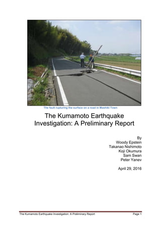
The fault rupturing the surface on a road in Mashiki Town
The Kumamoto Earthquake
Investigation: A Preliminary Report
By
Woody Epstein
Takanao Nishimoto
Koji Okumura
Sam Swan
Peter Yanev
April 29, 2016
2. The Kumamoto Earthquake Investigation: A Preliminary Report Page 2
Please Note
The material in this report is the sole property
of the authors and their respective companies
or institutions unless otherwise stated.
Any reproduction or use of this material
without their express permission is strictly
prohibited.
3. The Kumamoto Earthquake Investigation: A Preliminary Report Page 3
Table of Contents
Authors' Information........................................................................................................... 4
Forward: Accompanying US Earthquake Engineers to the Mashiki Area - Takanao
Nishimoto (in English and Japanese)................................................................................ 6
Introduction - Woody Epstein .......................................................................................... 10
Where else could this happen? – Peter Yanev ............................................................... 13
Earthquake Geology of the April 16, 2016 Kumamoto Earthquake – Koji Okumura ... 19
An Overview of the Kumamoto Earthquake Sequence – Sam Swan ............................ 25
Schools in the April 16, 2016 M7.0 Kumamoto Earthquake – Peter Yanev ................... 50
The Nishi-Kumamoto Hospital in the April 16, 2016 Kumamoto Earthquake – Peter
Yanev................................................................................................................................. 59
The Kumamoto Airport in the April 16, 2016 Kumamoto Earthquake – Peter Yanev .. 69
Shakeman: Strong Motion and Experience – Woody Epstein ...................................... 77
4. The Kumamoto Earthquake Investigation: A Preliminary Report Page 4
Authors
WOODY EPSTEIN, since 1983, has been a probabilistic risk
assessment (PRA) practioner, he has been a team member of
several diverse projects, such as a member of the PRA team
which analyzed the US Space Shuttle after the Challenger
accident; the Abandoned Chemical Weapons in China PRA,
the active fault studies at the Tsuruga and Higashidori, and the
IAEA Mission to Onagawa after the Great Eastern Japan
Earthquake. He lives north of Tokyo, Japan, and is the
Director of Safety and Risk in Asia-Pacific for the Curtiss-
Wright Corporation. He serves as the leader for this
investigation.
eMail: woody.epstein@curtisswright.com
PETER YANEV, founder of Yanev Associates, is
widely regarded as a leading authority on
earthquake engineering and strategic risk
management for natural hazards. Peter co-
founded EQE International in 1981 and grew the
company to over 750 professionals. He has
worked in earthquake engineering and earthquake
risk management since 1970. He has personally
visited or sent teams to investigate the effects of
over 100 earthquakes around the world since
1971. He lives near Berkeley, California, USA.
eMail: peter@yanev.com
KOJI OKUMURA, a Professor at Hiroshima
University, received his PhD from the University of
Tokyo in 1987 on Quaternary Tectonics. He was
working on earthquake geology in the Geological
Survey of Japan until 1996, the US Geological
Survey in 1991, and now at Hiroshima University.
He is an active member of the Scientific Committee
of the IAEA-International Seismic Safety Center,
The Science Council of Japan, and at the
Headquaters for Earthquake Research Promotion
of the Government of Japan, and is an Expert
Member of the Nuclear Safety Committee of Japan.
Koji-san has visited more than 100 fault sites around
the world where and has great skill in reading
epigramma, and understanding context.
eMail: kojiok@hiroshima-u.ac.jp
5. The Kumamoto Earthquake Investigation: A Preliminary Report Page 5
Sam Swan is a graduate of Stanford University with
professional licenses in mechanical and nuclear
engineering, having worked 40 years primarily in the
electric power industry focusing on natural hazard risk
assessment. He has performed detailed investigations
of some 30 earthquakes throughout the world under
the sponsorship of the Earthquake Engineering
Research Institute (EERI), the Electric Power
Research Institute (EPRI) and the Seismic
Qualification Utility Group (SQUG). He has been an
independent consultant since 2004 following 23 years
as a senior engineer with EQE and later ABS
Consulting. His particular interest is the application of
actual earthquake experience to the risk assessment
or seismic qualification of standard mechanical,
electrical and electronic equipment.
eMail: sswan100@sbcglobal.net
Takanao Nishimoto is a nuclear engineer with
experience in engineering, operations, and
maintenance. He received a nuclear engineering MS
degree from Kyoto University in 1976. His experience
began as a core management engineer at JAPC’s
Tsuruga Unit 1. He spent three years in Washington
DC as a seconded researcher to Japan Electric
Information Center from JAPC and worked for four and
half years at a think tank in Washington DC as an
executive technical director for nuclear power related
technical research projects. He received certification
as Chief Reactor Engineer from then Ministry of
Science and Technology, 1979 and Chief Radiation
Handling Engineer from the then Ministry of Science
and Technology, 1980. He is an independent
consultant working with Curttiss-Wright, Japan serving
as a Senior Engineer and Senior Advisor.
eMail: nishimototakanao@aol.com
6. The Kumamoto Earthquake Investigation: A Preliminary Report Page 6
Forward
Accompanying US Earthquake Engineers to the Mashiki Area
Takanao Nishimoto
On April 18 I visited a small village called Shimo-Otari in Mashiki-cho, the most affected area
from the Kumamoto Earthquake with US Risk analysts.
The village was the place where I saw the damage from an earthquake with my bare eyes
for the first time in my life. It is sitting on the narrow valley on the south side of a hill on
which Aso-Kumamoto airport is located. Houses in the valley are mostly typical old
Japanese houses with heavy tiles. A family standing by a completely fallen down wooden
warehouse told us that it survived the first shake but the second Shindo-7 shake on the 16th
gave the last blow. A new landslide at one of the cliffs along the small river in the village
prevented us from driving down to the center of Mashiki-cho that first day
Early next morning, we started the investigation from the same village again with two US
earthquake engineers and a Japanese geologist. Downstream of the small river where its
dike was heavy damaged was an elementary school which looked not affected by the
earthquake. After we identified ourselves and explained the purpose of the visit, the
teachers and the principal welcomed the strangers amid the efforts to restore the fallen
down shelves, pictures, etc. inside the school. The principal guided us to the locations about
which he was most concerned to know if the building damage was critical.
Then the next a half hour was an eye-opening experience for me.
The experienced US earthquake engineer quickly walked through the elementary school
buildings with the principal, checking the cracks on the walls and floors explaining to the
principal why he did not see them critical. The principal, who seemed very happy with the
investigation results from the expert, asked specifically to check the safety of the bridge
crossing the nearby river because it is the only evacuation path for people living on the
school side of the small river to the opposite side, and the only access path for school
children to come to the school. The expert did not take more than a minute to come to the
conclusion that the bridge has no problem with bolts fixing steel beams to bridge columns.
It was a bit of a surprise and a shock to me when the expert later said that he was ashamed
to see no inspectors dispatched by the local municipal office to check these public facilities
aftermath of this big earthquake, which is common in the US.
Then we reached the central part of Mashiki-cho where most severe damage was reported.
A US earthquake engineer who has witnessed the earthquake sites in Japan since 1978,
including the Miyagi-Oki Earthquake, pointed out that this Kumamoto earthquake can be
characterized as one with the strongest acceleration and all sorts of earthquake associated
phenomena such as landslide, settlement, strong ground motion and etc.
7. The Kumamoto Earthquake Investigation: A Preliminary Report Page 7
Here again, the people suffering from the damage to their property and fear of losing their
place to live were quite open to listen and accept the evaluation of their house condition
from unexpected foreign experts. Housewives from a public housing complex, who came
back to clear the mess inside, were very anxious about if they could return to their home.
They looked very relieved with the expert’s words.
I witnessed one more case which shows how the US expert is really a practical earthquake
engineer. We visited the Mashiki-cho sport center which was being used as a shelter and
where Japan Self Defense Forces had set up necessary equipment to provide food and water
to the evacuees. After looking at the outside and inside of the center, the US expert asked
me to interpret his recommendation to one of the young SDF staff. He demonstrated that a
low height concrete wall was little bit tilted. It was just in front of the entrance separating a
ramp for wheel chair riders from a ramp for vehicles and he could make it fall down by just
pushing the wall. He suggested either bringing it down or putting a rope around the area
where the wall could fall down. It was a pleasant scene for me to see the young staff
immediately run to report his senior.
There were other occasions where we were welcomed to provide evaluations and
suggestions to various sectors including a small airline company, a concrete mixing
company, and a private hospital.
On the other hand, we failed to access to large companies such as a motorcycle
manufacturer and utility company. The larger an organization becomes, the more difficult it
becomes to make a quick decision at the front end in the field.
10. The Kumamoto Earthquake Investigation: A Preliminary Report Page 10
Introduction
Background
At 21:30 on April 14, 2016, an M6.5 earthquake struck along the Furogawa and Hina-gu
faults on the island of Kyushu, the southern most main island in the Japan archipelago,
about 15km east of Kumomoto City. The strongest ground motion recorded was about
931gal, or about 0.94g, in Mashiki Town.
This proved to be a foreshock1
. Twenty-eight hours later, in the same area, a stronger M7.0
earthquake occurred with ground motion in Mashiki Town reaching 1165gal, or 1.18g,
rupturing the surface in several places. The two earthquakes are shown below in yellow.
The historical earthquakes in the area are shown with the dates of occurrence; the circle size
indicates the Mw magnitude of the earthquakes.
Date/Time JST Mw M Shindo gal Location
4/16/16 at 01:25 7.0 7.3 6.5 1362.1 32.75N, 130.76E
4/14/16 at 21:26 6.0 6.5 6.4 1579.7 32.74N, 130.81E
4/15/16 at 00:03 6.1 6.4 5.7 606.3 32.70N, 130.78E
1
A foreshock of 7.3Mw also preceded the main shock, 9.0Mw of the Great Eastern Japan Earthquake.
11. The Kumamoto Earthquake Investigation: A Preliminary Report Page 11
A note is in order here about the difference between magnitude measurements. Mw is just
the seismic moment back-converted to a magnitude using a formula due to Kanamori
(1977).
The Japan Meteorological Agency (JMA) has its own "legacy magnitude" that it still uses.
Basically they measure an amplitude from each seismogram, take the logarithm, and apply
various corrections. This is what Richter did when he defined magnitudes. There is no
reason why Mw and the JMA magnitude should agree for each quake, and they don't.
The JMA magnitude for the April 16 (local time) Kumamoto quake was 7.3, as opposed to
Mw of 7.0 by the USGS (http://www.japantimes.co.jp/news/2016/04/16/national/more-
powerful-magnitude-7-3-quake-rocks-kumamoto-kills-dozens-more/#.VyU69iEopMF.)2
Curtiss-Wright Nuclear Division, Japan, formed a small earthquake investigation team of
experienced earthquake engineers, risk analysts, and geologists to visit Kyushu from the
evening of 4/17 until the morning of April 23. The team was made up of some of the same
investigators who were on the IAEA Mission to Onagawa after the 3.11 Great Tohoku
Earthquake. The team members were:
1. Woody Epstein, Curtiss-Wright Director of Safety and Risk, Asia-pacific, IAEA
Mission team member and the investigation leader;
2. Takanao Nishimoto, Curtiss-Wright Senior engineer and Senior Advisor;
3. Peter Yanev, Yanev Assoc., earthquake engineer, and IAEA Mission team
member;
4. Sam Swan, Acceptable Risk LLC, earthquake engineer, and IAEA Mission team
member;
5. Koji Okumura, geologist from Hiroshima University (and who did the active fault
studies with Woody Epstein at Tsuruga, Higashidori, and Shika NPPs)
Our goal was to gather preliminary data about successes and failures of structures, systems,
and components (SSCs) which can have a direct bearing on industrial facilities, hospitals,
schools, and power plants, including nuclear power, and then write an investigation report.
For the SSCs, we planned to go to key industrial facilities which are still closed for damage
checks. Many industrial facilities have similar equipment to nuclear power plants and in
Japan these SSCs are classifies as “S” class (safety class) SSCs which can withstand 0.6g.
We also intended to visit local sub-stations and switchyards to investigate success and
failures.
We had collected and analyzed the strong motion records for the three biggest events on
April 14 through April 163
(M6.4, M6.5, and M7.3, see the table on page 10). In this way, we
can begin to relate failures and successes with the damage indicating parameters from the
2
Thanks to Dr. Robert Geller, Tokyo University, Department of Earth and Planetary Science, for the clear
explanation.
3
All dates are Japan Standard Time.
Mw should be the same no matter who measures it, but since the inferred moment can vary
depending on the data used and so on it, will actually vary a bit.
12. The Kumamoto Earthquake Investigation: A Preliminary Report Page 12
strong motion records. This has rarely been done before and should be of great interest and
use around the world4
.
As Peter Rickwood, a member of the Onagawa mission, stresses, any earthquake inquiry
investigation is, hopefully, of an independent, open ended nature. A good investigation is
not to give the final word on "safe or not", but rather to make sure the truth is reported and to
ensure that scientific and social conversations continue in open and transparent ways.
The Report
The structure of this report is different than most earthquake investigation reports. We have
decided to allow each team member to write stand alone sections reflecting their expertise,
observations, preliminary conclusions, and reflections. Some sections complement each
other; some sections may differ in opinions. Some may even contradict each other. We
wanted each section to be able to stand alone.
Indeed, these differences reflect and reveal the uncertainties in earthquake engineering and
the earth sciences: uncertainties as to why buildings fail or do not during earthquakes;
uncertainties about the likelihoods (not probabilities) of earthquake recurrence rates;
uncertainties about hazard maps5
; our incomplete knowledge about existing faults, and
faults we did not know even existed6
.
This not to say that each section has a sole author in the broader sense. Being together for
12 to 14 hours a day, engendered lively (and sometimes exhausted) conversations. Koji
Okumura enlightened us all about the geotechnic features he was seeing; Peter Yanev
explained in detail what to look for when assessing damages; Sam Swan, while collecting
data, expounded on our lack of knowledge of when SSCs fail or succeed; Woody Epstein
shared his analyses of the strong motion records and used his software to create strong
motion records for the group; and Takanao Nishimoto provided cultural, geographic, and
historical contexts as he drove us tirelessly around the Kumamoto area, which was plagued
with traffic jams caused by road, Shinkansen (bullet train), and other train line closures.
So without further ado, let us proceed to the authors' contributions. And again, please note,
that this is only a preliminary report. We hope that you, the reader, will join in this scientific
conversation and will make contributions which will be incorporated in subsequent versions
of the report, so as to make this a true open source, living document.
Woody Epstein, April 27, 2016
Curtiss-Wright, Nuclear Division
4
The IAEA Mission to Onagawa collected success and failure data and does have the strong motion records
with which to relate successes and failures of SSCs with the damage indicating parameters. Unfortunately,
these data and relations have not been put into a database, nor have they been released to the public.
5
See Geller, R.J., Mulargia, F., Stark, P.B., 2015. Why we need a new paradigm of earthquake occurrence, in
Subduction Dynamics: From Mantle Flow to Mega Disasters, AGU Geophysical Monograph 211, G. Morra et al,
Eds., pp. 183-191, or Kagan, Y.Y., Jackson, D.D., Geller, R.J., 2012. Characteristic earthquake model, 1884-2011,
RIP. Seismological Research Letters 83, 951-953 and
http://www.seismosoc.org/Publications/SRL/SRL_83/srl_83-6_op/.
6
The Nojima Fault, which caused the Great Hanshin Earthquake, 1995, is an example.
13. The Kumamoto Earthquake Investigation: A Preliminary Report Page 13
Where Else Could This Happen: The Berkeley Hills,
Los Angeles, Portland, Seattle, Vancouver?
Lessons from Japan’s Latest Destructive Earthquake
for Home and Building Owners:
I observed the effects of the latest big earthquake in Japan (Magnitude 7.0 near Kumamoto, Kyushu
on April 17, 2016 within less than 56 hours after I left the comfort of my wood frame house in the
Berkeley Hills of California. That was also about 3 days after the earthquake and 4 days after the
M6.3 foreshock of April 16 that originally, to all, seemed like the main event.
The small town of Mashiki is a few miles east of the City of Kumamoto, but unfortunately right on
top of the Futagawa Fault, the cause of the earthquake. While Kumamoto had moderate (and some
spectacular) damage, much of Mashiki looked like a war zone. A large proportion of its wood frame
homes and smaller commercial buildings were in ruins. In some areas, all buildings in view were
destroyed; in other areas maybe 20% were affected severely (at least structurally). In total for the
area, perhaps 15% of the buildings need to be rebuilt from scratch and more than 30% of the
buildings will require expensive repairs.
A view of a residential area at the foot of the hills in the Town of Mashiki. All of the damaged houses are
wood-frame construction.
The M6.3 earthquake/foreshock may have been the best thing to happen to Mashiki, and much of
the Kumamoto area, in this earthquake sequence. It was strong and destructive enough to put
everyone on alert, and to damage somewhat the weakest buildings. So, when the main M7.0
earthquake happened many of these buildings were not occupied – which should help explain the
low overall casualty numbers – less than 50 died in the two earthquakes in an area with about a
million people.
14. The Kumamoto Earthquake Investigation: A Preliminary Report Page 14
Another view of a heavily damaged residential area of Mashiki. All of the houses in the photo are
wood frame; most are relatively new.
The town and its much bigger neighbor, Kumamoto, remind me of Berkeley and San Francisco.
Berkeley is right on top of the Hayward Fault, just like Mashiki is on top of the Futagawa Fault. Both
faults are strike-slip faults – in effect they are both faults that cause primarily faulting in the
horizontal direction, with some faulting, or slippage, in the vertical direction. Our primary concern
with the Hayward fault is a Magnitude 7+ earthquake. That is effectively exactly what happened with
Mashiki’s Futagawa Fault. The maximum horizontal slip in Mashiki was about 2m (6+ feet) and the
maximum vertical slip (uplift) was about 0.7m (2.25 ft). That is, more or less, what we expect on a
similar earthquake in the East Bay somewhere from Richmond south to Hollister. If the earthquake is
centered on Berkeley for example, then we have something like a worst-case scenario from
Richmond south to Fremont (but not for Silicon Valley).
Faulting, along the Futagawa fault through a hilly residential area of Mashiki. At this location the fault has
offset a retaining wall about 4 feet (1.2m). Houses founded right on top of the fault were typically
completely destroyed. Nearby wood frame houses, not directly on the fault, had various degrees of
structural damage – from light to extreme, including many collapses.
Before I discuss what happens to the East Bay with such an earthquake centered on Berkeley, I
would like to mention similar scenarios are likely in other areas along the Pacific coast, from San
Diego to Portland to Seattle to Vancouver. In the LA area, a similar earthquake can happen on the
Santa Monica Fault, on the Hollywood Fault, on the Newport-Inglewood Fault, and on many more. In
15. The Kumamoto Earthquake Investigation: A Preliminary Report Page 15
the San Francisco Bay Area, such earthquakes can be postulated for the San Andreas Fault from San
Jose all the way up past Marin County, for example. Similarly sized earthquakes, with somewhat
different fault characteristics, can happen right below Portland (on the Portland Hills Fault), right
below Puget Sound on the Tacoma Fault or the Seattle Fault, and in the Vancouver Area (the Lower
Mainland) below Vancouver and underneath Victoria on Vancouver Island. Since earthquakes on
primarily vertical faults (called thrust faults) are, typically, more damaging to structures and
infrastructure than faults like the Futagawa and Hayward Faults, the example of Mashiki will suffice
for now.
The number one reason engineers, geologists, scientists, sociologists, and others go to earthquakes
is to observe and to learn what actually happens – both the positive and the negative. The positive
would be successful performance of buildings (no damage to minor damage); the negative would be
surprising new damage or other unexpected results (based on prior experience and analyses).
On the left is a practically undamaged house not far away from a severely damaged house (on the right). The
difference in performance here is primarily due to the lack of bracing in the garage in the house on the right.
Note the unbroken window on the second floor.
I have been going to earthquake sites since 1971 and the M6.5 San Fernando, Los Angeles Area
earthquake. Since those first impressions and new experiences in the San Fernando Valley, I have
gone to more than 50 earthquakes around the world and sent teams to another 50+. Many of these
were in Japan; more were along our shores of the Pacific. Unfortunately, what I saw surprised me. It
exceeded my expectations of what can happen to reasonably modern buildings in the hills and
nearby areas of all of the regions of the West Coast listed above. The damage caused by the shaking
combined with the ground failures in and around the hills was much more than I have seen before,
or expected to see anywhere.
16. The Kumamoto Earthquake Investigation: A Preliminary Report Page 16
Another house with too many openings (windows) and not enough walls on the ground floor. Note the
relatively undamaged houses behind and on the right of the collapsed house.
Other severely damaged houses in Mashiki. Most of the damage that occurred was due to too many
windows and not enough strength in the lower floor walls. That additional strength can be easily provided
with the bracing provided by a few morewell-nailed plywood sheets.
Most of the buildings that failed were made of wood, just like most of the residential inventory along
the Pacific Coast. Some were concrete buildings. My team colleagues and I did not observe any failed
steel framed buildings.
Many of the failed houses and smaller buildings had heavy tile roofs, much like the tile roofs popular
in Southern California and prevalent on older, Mission Style buildings throughout California. These
were often also older buildings, built to outdated codes, such as those along the West Coast
17. The Kumamoto Earthquake Investigation: A Preliminary Report Page 17
predating the 1950s – examples would include older houses with wood framing and exterior and
interior stucco and plaster walls.
But, many of the failed buildings were new to relatively new, and built to modern Japanese
standards, which tend to exceed the requirements of our codes along the West Coast when it comes
to earthquakes.
As shown in the photographs below, much of the damage was due to what seemed to be localized
failures of the ground beneath the houses and other buildings. Those failures included localized,
small landslide like slumps, and lots of ground settlement (or compaction) caused by the shaking of
the ground itself during the earthquake. What was really surprising is the extent of the damage
caused by this combination of very strong shaking near to the fault and minor ground failures
around and under the buildings. I have seen a lot of damage from both shaking and ground failures
(such as landslides), but never quite this much. Not nearly this much!
Much of the damage to houses in the hills was also due to ground failures around the house foundations.
That was caused by minor local land sliding and/or the slumping of inadequately compacted fills around the
houses. These types of fills are necessary to create level pads for the house foundations, as is the common
practice along the West Coast of the US and Canada. What was surprising in Mashiki was the extent of such
failures. The likely cause of this unusually high damage is the very strong shaking in the immediate vicinity
of the fault.
The worst damage occurred exactly where I expected it. That was in the flat ground just before the
ground started sloping upwards to become hills. That is the interface between the relatively soft flat
ground (just like in Berkeley west of the University campus). The severe damage extends up into the
hills for a few hundred yards (meters) and dies down beyond that. This concentration of damage is
partially due to the way the earthquake waves are reflected and refracted at the interface within a
few hundred yards in either direction. Again, I have observed this many times before, but the
observed (and recorded nearby) shaking in this case seems much more severe.
18. The Kumamoto Earthquake Investigation: A Preliminary Report Page 18
Damage to a house in the hills above Mashiki primarily caused by local ground failure, either due to minor
landsliding or inadequate compaction of fill in the construction of a level building site. The building is
leaning to the right; the main ground movement is to the left and downhill.
The other hill areas, like the Berkeley hills, typically have numerous landslide areas and areas with
slowly creeping surface soil, which can suddenly slide in a major rainstorm or in a stronger
earthquake. Many of these areas were built-up in the past, before the more stringent recent codes.
What the Kumamoto earthquake shows us is that damage to houses in the hills, and near the
causative fault, can be much more extensive than most of us realize.
In conclusion, this earthquake demonstrates that damage to reasonably well built houses near
faults, and particularly houses near the base of hills (upslope as well as in the flat) in the general
proximity of faults can be much more severe than generally expected. Houses and other small
buildings near faults, and particularly built in the hills near faults, should be expected to suffer
proportionally more damage. This earthquake should be a warning both to homeowners and their
insurers. This applies to Japan, as well as to the entire Pacific Coast of North America.
19. Earthquake Geology of the April 14 and 16, 2016 Kumamoto Earthquakes
Koji Okumura (Hiroshima University, kojiok@hiroshima-u.ac.jp)
[This is a preliminary report based on limited information as of April 28, 2016 and shall be revised and corrected. Click HERE for new version.]
1. Overview
A Mw 7.0 earthquake hit west central Kyushu island in west Japan at 01:25 JST on April 16,
2016. Reportedly 49 were killed, 1 are missing and more than thousand are injured as of April 27. 28
hours before, at 21:26 JST on April 14 another Mw 6.1 had shook the same region severely. Intense
ground shaking by two successive earthquakes caused structural damages in an extensive area. The
shakings by a large number of aftershocks force 90,000 people to evacuate from their homes no matter the
homes were damaged or not. And the extensive damages to infrastructures make their lives more difficult.
Previously mapped and evaluated Futagawa and Hinagu fault zones are the sources of these two
earthquakes. The Futagawa fault zone, the northeastern portion of the two fault zones runs about 30 km
ENE-WSW. The longest section of the NE portion is called Futagwa fault. The SWS-NEN trending
Hinagu fault merges with the Futagawa near its west termination (F and H in figure 1). The Futagawa
fault is the source of the Mw 7.0 with 2 m+ right-lateral strike-slip at the surface. The Mw 6.1 ruptured
about 15 km long northernmost section of the Hinagu fault without surface ruptures. Minor surface
ruptures appeared in this section during the Mw 7.0.
2. Tectonics
The earthquake occurred on the south margin of the Central Kyushu rift. Central Kyushu is
the only area of volcanic extensional tectonics in Japan, where EW compression is predominant. Unzen
volcano in west of Kumamoto, Aso volcano, and Beppu-Haneyama graben in east are within this NS
extending volcanic graben. In southwest, the graben is believed to continue down to the Okinawa trough,
the active back-arc spreading center behind the Ryukyu island arc. In northeast, the graben terminates in
Beppu bay and the active tectonics shift to strike-slip of the Quaternary Median tectonic line (figure 1).
In west of the Quaternary Median tectonic line, there is a continuous boudary between Mesozoic
subduction-related sediments in south and the Neogene volcanics and sediments in north. The Median
tectonic line in Shikoku is a very active Quaternary transform, but the activity is replaced with normal
faulting on shore Kyushu in most part of the graben. So, the geologic boudary along the south margin of
the grabe is mostly inactive except for the Futagawa fault.
The Futagawa-Hinagu fault zone is driven both by the EW compression derived from Philippine
Sea plate subduction and by the N-S extension of the Central Kyushu rift. The slip is right-lateral strike-
slip with south-side-up normal separation. That means the WSW-ENE strike Futagawa fault is dipping
NWN and the NEN-SWS strike Hinagu fault is dipping WNW. The dips are within 60 to 80 degrees.
On both faults, right-lateral strike-slip is predominant, but the uplift of the Kyushu mountains in south is
due to the normal component of the fault movement.
The Kumamoto Earthquake Investigation: A Preliminary Report Page 19
20. 3. Earthquakes
The April 14 Mw 6.1 recorded the highest JMA intensity scale of 7 at Mashiki JMA (Japan
Meteorological Agency) station. The KiK-net (Strong-motion Seismograph Network of the National
Research Institute for Earth Science and Disaster Prevention: NIED) maximum peak ground acceleration
at Mashiki (KMMH16) was 1580 cm/s2 in the area of the JMA intensity scale of 7.
http://www.j-risq.bosai.go.jp/report/static/R/20160414212642/0131/00001/R-20160414212642-0131-
00001-REPORT_EN.html
http://www.kyoshin.bosai.go.jp/kyoshin/topics/html20160414212621/main_20160414212621.html
http://www.fnet.bosai.go.jp/event/tdmt.php?_id=20160414122500&LANG=en
The Mw 6.1 ruptured the deeper part of the northernmost section of the Hinagu fault. Strong
ground motion took place in north and northwest of the epicenter or respectively in Mashiki town and
Kumamoto city. The intensity 7 at Mashiki may be due to the directivity effect of the northward rupture
propagation on the Hinagu fault. The radiation of strong seismic wave perpendicular to the WNW
dipping Hinagu fault plane may be the cause of the strong shaking in Kumamoto.
The Mw 7.0 earthquakes on April 16 occurred during the aftershock sequence of a Mw 6.1
earthquake at 21:26 JST on April 14, 2015. Therefore the Mw 7.0 "aftershock" on April 16 was
Figure 1 Quaternary faults and earthquakes in Northern Kyushu
Quaternary faults: Nakata and Imaizumi eds. (2002), Research Group for Active Faults of Japan (1995)
Historic earthquakes: Usami (1996)
The Kumamoto Earthquake Investigation: A Preliminary Report Page 20
21. immediately redefined as a "mainshock" after the occurrence and the Mw 6.1 "main-shock" was redefined
as a "foreshock". The Mashiki JMA station again recorded intensity 7. The Mashiki KiK-net station
KMMH16 recorded 1320 cm/s2 this time, a little smaller than during the Mw 6.1.
http://www.j-risq.bosai.go.jp/report/static/R/20160416012514/0424/00002/R-20160416012514-0424-
00002-REPORT_EN.html
http://www.kyoshin.bosai.go.jp/kyoshin/topics/html20160416012405/main_20160416012405.html
http://www.fnet.bosai.go.jp/event/tdmt.php?_id=20160415162400&LANG=en
The main-shock caused extensive structural damages along the Futagawa fault and further east and
further west of the fault. The shaking was again the most intensive at Mashiki town. Many houses that
were already damaged by the Mw 6.1 collapsed during the Mw 7.0. The extremely strong shaking may be
due to the directivity effect of the up-dip propagation of the rupture on the Futagawa fault under Mashiki
town, which is located between the epicenter in north and the surface fault in south. Both the epicenter
and the fault are two kilometers away from the Mashiki town in opposite directions. The fault plane dips
60° (by GSI: http://www.gsi.go.jp/common/000139798.pdf) to 84° (f-net moment tensor: http://www.
fnet.bosai.go.jp/event/tdmt.php?_id=20160415162400&LANG=en) NWN and hypocenter depth is 14
km. The ground acceleration spectra of NIED's KiK-net show significantly larger acceleration at 0.5 to 1.0
Hz by the Mw 7.0 than by the Mw 6.1. Though the peak ground acceleration is smaller by the Mw 7.0,
this larger acceleration at 0.5 to 1.0 Hz might account for the heavier damages to Mashiki town by the
Mw 7.0.
The rupture propagated toward ENE along the strike of the Futagawa fault. At the end of the
rupture is the Minami-Aso village, where 14 were killed and many slope failures occurred. The source
fault terminates in the east bank of the Shirakawa barranca where the fault intersects with the Aso caldera
rim. In this area, topographic relief is much larger than in other source region for the 300--700 m high
caldera walls, 100--150 m deep barranca gorge, and steeply eroded edifices or the central cone volcanoes
in east. The steep slopes failed at many locations by the shaking of the mainshock, probably intensified by
directivity effects. The Late Quaternary sediments filling the Aso Caldera (95000 years old) also amplified
the ground motion to cause many structural damages.
4. Crustal movement and surface faulting
The Geospatial Information Authority of Japan (GSI) published the GEONET (GNSS Earth
Observation Network System) observation and model, and SAR (Synthetic Aperture Radar) interferometry
results using the ALOS-2 (Daichi-2) satellite together with a lot of low-altitude air-photos and UAV
movies.
http://www.gsi.go.jp/BOUSAI/H27-kumamoto-earthquake-index.html
Mw 6.1 foreshock
http://www.gsi.go.jp/common/000139760.png
Mw 7.0 mainshock:
http://www.gsi.go.jp/common/000139809.png
http://www.gsi.go.jp/common/000139905.pdf
The SAR interferometry results clearly demonstrate how faulting occurred and how the surface was
deformed. The deformation by the Mw 6.1 is broad and as small as 10 to 20 cm over 10 km wide areas.
There was no surface rupture. After the Mw 7.0 more than 10 fringe cycles appeared along the Futagawa
fault corresponding to up to 2 m strike-slip offset at the surface on the fault. Along the northernmost
The Kumamoto Earthquake Investigation: A Preliminary Report Page 21
22. Hinagu fault, the sharp line cutting through frings coincides with the observation of ~25 cm offset by
Tohoku University geologists (http://irides.tohoku.ac.jp/irides-news/20160417/289).
According to the preliminary reports from the field and the author's own survey, up to 2.0 m
consistent right-lateral strike-slip is observed on the Futagawa fault. The vertical component is usually up
to 0.5 m south-side-up, but up to 0.2 m north-side-up deformation is also observed. The offset along the
northernmost Hinagu fault is also right-lateral strike-slip. In addition to the slip along the master strands,
a 5 km long branch fault of up to 1.2 m right-lateral strike-slip appeared in the east of and under Mashiki
town (Kumahara et al.: http://jsaf.info/jishin/items/docs/20160420164714.pdf). There also appeared
a conjugate fault with left-lateral strike-slip. These branch faults appeared on modern alluvial plain and
there was no remnant of previous slips. The field report of Geological Survey of Japan by Shirahama et al.
(http://g-ever.org/updates/?p=334) shows many offset features in the central section of the Futagawa fault.
Geospatial Information Authority of Japan (GSI) report (http://www.gsi.go.jp/common/000139911.
pdf) based on UAV survey (https://www.youtube.com/watch?v=bS6ftodIHeI&feature=youtu.be) shows
the surface rupture near the ENE termination of the Mw 7.0 fault inside the Aso caldera just east of the
barranca. The 5 km section of the ENE termination has not been mapped previously.
Most of the Mw 7.0 surface rupture appeared along the previously mapped ~30 km strands of the
Futagawa and Hinagu fault. However, the occurrence of the branch faults, south-side down dip-slip, as
well as the unmapped termination section presented much more complicated faulting took place in longer
than expected source fault.
5. Soil condition in Kumamoto--Mashiki area
Kumamoto city and Mashiki town are located north of Kumamoto alluvial plain (Heiya). Look
at the area in the seamless geologic map by the Geological Survey of Japan at https://gbank.gsj.jp/seamless/
seamless2015/2d/index.html?lang=en. Kumamoto Heiya is a Holocene alluvial plain (unit 1). The alluvial
plain, especially in its southern and eastern parts are mostly too wet for developing and used as paddy
fields. Northern half of Kumamoto city and Mashiki town are located north of the plain on Pleistocene
fluvial terraces (170 and 171) and on early Late Pleistocene pyroclastic flow (95 and 83). The Futagawa
fault cuts the lava plateau (83) and continues along the boundary between the Kumamoto Heiya (1) and
Cretaceous rocks. The Hinagu fault in south juxtaposes alluvial plain (1) with bedrocks and run north
through bedrocks to merge with the Futagawa fault.
According to Ishizaka et al. (1975: The Quaternary Research [Tokyo], vol. 34: https://www.jstage.
jst.go.jp/article/jaqua1957/34/5/34_5_335/_pdf), the Kumamoto Heiya is an area of active subsidence
at a rate of 0.90 mm/yr near the coast and 0.45 mm/yr in south of Kumamoto city. With this subsidence
rate, 900 m to 450 m sediments are to be accumulated in a million years under the Kumamoto plain. It
is very likely this zone of subsidence continues toward east along the Futagawa fault in south and Mashiki
town in north.
In the J-SHIS Japan Seismic Hazard Map (http://www.j-shis.bosai.go.jp/map/?lang=en) large
site amplification is expected in Kumamoto plain and intensity 6+ to 7 is forecasted in case of Futagawa-
Hinagu fault zone earthquake. The Kyushu Express way (right green line) got severe damage on this
alluvial plain and is closed now. An express way bridge in the middle of the plain barely survived from
collapsing with structural damages. However, the eastern part of the plain is so wet for developing there
were no house to be damaged.
Mashiki town, where the severest structural damages took place, is located across the plain from
The Kumamoto Earthquake Investigation: A Preliminary Report Page 22
23. the unit 100 isolated volcanic hill in the geologic map. The center of the town is on the south-facing
slope above 11 m high alluvial plain and below 40 to 50 meter high upland consists of Late Quaternary
sediments and pyroclastic flows. Subsurface geology is not known yet, but there should be a few hundred
meters of sediments that were laid down in pace with the subsidence in south. The sediments may be
deposited above south facing bed rock slope as there are hill of Cretaceous rocks several kilometers north.
The KiK-net 1580 cm/s2 and 1328 cm/s2 peak ground acceleration, as well as intensity 7 were
recorded on the flat top of the upland away from the slope and the alluvial plain. The very strong ground
shaking here even destroyed rather new houses on the flat top of the upland where no amplification by
surface soil is expected. Therefore the effect of the deeper subsurface sediments and structures on the
ground shaking are to be investigated. The significant thickness of Late Quaternary sediments as well as
the shape of the basin may have affected the ground shaking on the Mashiki upland.
The author also observed a lot of gravitational slides and lateral spreading on the south-facing slope
and on the slopes along incising creeks. There are many collapsed houses owing to this geotechnical causes
in addition to the vibration effects. At the foot of the slope, a river runs along the boundary between the
upland and the alluvial lowland. The river erodes the upland and fill its course with soft sedmients. There
is no clear erosional scarp along the bank, but the sediments of the upland should contact with the alluvial
sediment with buried scarps. This situation may be the cause of lateral spreading and sliding in the lower
part of the slope. 8 fatalities by the Mw 6.1 foreshocks were reported along the foot of the scarp.
The most intense ground shaking at Mashiki town is presumably due to the effects of seismic
wave radiation and of rupture directivity both for the Mw 6.1 and the Mw 7.0. The failure of slopes and
possible lateral spreading are the additional cause to the shaking of the severest structural damages. Some
researchers claim the branch fault in east and under the town is the cause of the localized damages. It
is not likely because the ruptures in the sediments and shallow bedrocks generate neither strong ground
motion nor directivity effect. There is no significant concentration of damages by shaking along the master
strand of the Futagawa fault. This is clear and strong evidence that ruptures at and near surface have
nothing to do with strong vibratory motions.
In Kumamoto city, moderate structural damages took place extensively. The southern half of the
city has expanded into the Kumamoto Plain above hundreds of meter thick sediments. The northern half
of the city is on Late Pleistocene terraces on Quaternary volcanics. Thick soft sediments and rocks may
have amplified the ground motion. Detailed investigation on the soil condition and damages should be
carried out to understand seismic risks in the cities on soft sediments.
6. Past earthquakes and earthquake forecast
No historic earthquake larger than M 6.5 was recorded in the source area (figure 1). In
Kumamoto, M 6.0 to M 6.5 earthquake occurred every 50 to 100 years. These earthquakes killed 10s
of people and damaged Kumamoto castle repeatedly. So, the 2016 shaking in Kumamoto is not an
unusual event. Earthquakes larger than M 7.0 were inferred only by paleoseismological excavations on the
Futagawa-Hinagu fault zone.
HERP, the Headquarter for Earthquake Research Promotion of the government of Japan, had
evaluated long-term seismic potential of the Futagawa-Hinagu fault zone in 2002 and revised it in 2013.
The seismic risks of the Futagawa-Hinagu fault zone was evaluated by rather limited geologic information
of recurring earthquakes. For the Futagawa segment of the fault zone, an earthquake around M 7.0 with
2 m surface offset on a 19 km long rupture was forecasted. A M 6.8 earthquake was forecasted for the 16
The Kumamoto Earthquake Investigation: A Preliminary Report Page 23
24. km segment of northernmost section of the Hinagu fault, on which the Mw 6.1 occurred at depth and
surface ruptured during the Mw 7.1.
The conditional probability of the earthquake in 30 years was estimated as 0 to 0.9 %. This
estimate is based on two past earthquakes in paleoseismological excavations. The timing of the two events
are 2200 to 6900 years before present and 23000 to 26000 years before present. One or more events were
supposed to have been missing in the geologic records. Assuming 2 or 3 events since 26000 years ago,
recurrence interval was estimated as 8100 to 26000 years. The large uncertainty and long interval made
the probability less than 1 %. But 0.9 % 30-year probability is rather high for slow-moving intra-plate
faults in Japan and the highest possible ratio between the elapsed time and the recurrence time was 0.9 at
the highest.
Figure 2 Surface rupture at Shimojin (N32.49519° E 130.84871°)
The rupture offsets the southeast corner of a paddy by 1.2 m right-lateral strike-slip (east edge of the paddy)
and 0.4 m south-side-up. The slope to the left is a fault scarp of the Futagawa fault. It seems farmers cut
into the scarp to make the paddy wider and the scarp steeper. The fault passes just in front on left hand side
of the upper-right house. The house is almost intact.
The Kumamoto Earthquake Investigation: A Preliminary Report Page 24
25. The Kumamoto Earthquake Investigation: A Preliminary Report Page 25
An Overview of the Kumamoto Earthquake Sequence
Sam Swan, PE, Acceptable Risk LLC, Berkeley, California
The main shock of the Magnitude 7.0 Kumamoto earthquake sequence occurred at 1:25 early
Saturday morning (local time) on April 16, 2016. The main shock was preceded by a magnitude 6.5
earthquake at 9:26 in the evening on Thursday April 14. Damage from the initial earthquake alone
was sufficient to attract world news coverage. The sequence of a moderate-magnitude-followed-
by-large-magnitude earthquake illustrates the chance that any damaging earthquake may in fact be
a foreshock, followed within a day or two by a much larger event. Earthquake history indicates this
happens perhaps 10% of the time.
The earthquake sequence was centered in the western central section of Kyushu, the southernmost
main island of Japan. The earthquake was caused by a right-lateral-strike-slip movement on the
Futagawa-Hinagu Fault, which extends about 100 kilometers from the volcanic caldera of Mount Aso
in the northeast to the Yatsushiro Sea in the southwest near the City of Kumamoto. The Magnitude
7.0 main shock appears to result from a shallow rupture over about 30 kilometers of the Futagawa
fault (Dr. Koji Okumura, Hiroshima University). The fault rupture was centered in the small town of
Mashiki east of the City of Kumamoto. The fault broke the ground surface creating horizontal offsets
approaching 2 meters in roadways along the trace and passing through several homes.
The combination of earthquakes caused severe damage in residential areas near the fault’s surface
trace. Ground motion was recorded at dozens of instrument stations on Kyushu. The five strong
motion recordings nearest the fault trace measured between 0.50g and 1.4g peak horizontal ground
acceleration (1.0 g = the force of gravity). In the small area of most severe damage, effects would be
considered as high as Intensity Nine to Ten (MMI IX - X) on the conventional Modified Mercalli
Intensity Scale or intensity 7 on the Japan Meteorological Agency Scale, commonly called Shindo..
A small team of engineers was organized by the Curtis-Wright Nuclear Division of Tokyo. The team
arrived in the earthquake-affected area of Kyushu on Monday, April 18, two days after the main
shock of early Saturday morning. The engineering team spent five days in the damaged area
surrounding the City of Kumamoto. This brief post-earthquake study was intended to capture
general effects from the earthquake sequence through first-hand observations immediately
following the event.
26. The Kumamoto Earthquake Investigation: A Preliminary Report Page 26
General Observations
The most severe damage from the earthquake sequence was concentrated in a band approximately
3 kilometers east-west by 1 kilometer north-south along the north side of the valley that contains
the residential area of Mashiki . This zone of severest damage overlays the Futagawa fault plane
which dips to the north from the surface rupture. Severe damage appeared to rest on shallow
alluvial soil atop volcanic rock at the base of the low hills that bound the north side of the valley. This
region was of course also the focus of media coverage due to extensive collapse of homes and small
commercial buildings.
The area includes a combination of one and two-storey recent and older structures that would
represent a typical suburban area in any developed country including the United States. Building
codes in Japan include provisions for earthquake load that are comparable to high seismicity areas of
the United States. Major upgrade of the Japanese code in 1981 might be considered the time line
between older more vulnerable construction and more recent earthquake-resistant construction.
Homes and commercial buildings in Mashiki are generally wood-frame structures with stucco or pre-
fabricated siding. Homes typically are topped by tile roofs, which of course are a factor in
earthquake damage due to their mass. Commercial buildings and residential apartment buildings
are primarily reinforced concrete frame, with a few steel fame or concrete shear wall structures.
As expected partial or total collapse tended to occur in older structures although not without
exception for newer structures. As a rough estimate perhaps 10% of the housing and commercial
buildings in the heavily damaged Mashiki residential area were a total loss, suffering partial or total
collapse. Perhaps 50% of the structures in the area are salvageable but will require serious repair.
The surface trace of the fault on the southern side of the Mashiki Valley created
offsets in roadways and retaining walls and in a few homes. The photo looks west
along the Futogawa fault toward Kumamoto.
27. The Kumamoto Earthquake Investigation: A Preliminary Report Page 27
Effects to one- and two-storey wood frame housing resulted from a combination of strong ground
shaking and soil failure including landslide, soil slumping and settlement. The area of severe damage
includes a ground motion recording on the ridge atop the low hills bounding the north side of the
Mashiki Valley. The record averaged 0.93g (acceleration of gravity) in the two horizontal directions.
The area of most severe damage in Mashiki could be rated as high as Intensity Nine to Ten based on
effects. This area was surrounded by a much larger area perhaps 10 kilometers east-west by 5
kilometers north-south that would be rated Intensity Eight (MMI VIII). This area of moderate to
serious damage extended approximately from the Kumamoto Airport in the northeast to the edge of
the urban area of Kumamoto in the southwest. A larger area of perhaps 30 kilometers east-west by
20 kilometers north-south would be rated Intensity Seven. The experience for modern construction
in developed countries like Japan, with stringent seismic provisions in building codes, is that Intensity
Seven (MMI VII) is the threshold of damage to structures and contents. This area of Intensity Seven
or greater effects extended from the hills bounding the Aso Caldera in the northeast to the coastline
in the southwest. This region included the City of Kumamoto and the industrial areas to the
northeast and south. Soil conditions obviously had a significant effect on the level of ground shaking
and subsequent damage. Thus pockets of higher or lower shaking would be included in the general
regions outlined above. The map below illustrates the areas included in the engineering team’s
investigations and strong motion records in the region from the main shock of April 16.
City of Kumamoto
Uto
Kumamoto Airport
Industrial Zone
Mount Aso Caldera
Mashiki
Aproximate Fault Trace
Yatsushiro Sea
0.52g
0.74g
0.72g
0.36g
0.31g
0.61g
0.72g
0.93g
Industrial Zone
The general region affected by the earthquake is illustrated by the satellite image (courtesy Google-
earth) showing the approximate location of the fault rupture and the measured peak ground
accelerations (average of horizontal components). The peak ground accelerations are courtesy of the
USGS web site and Woody Epstein of Curtis-Wright, Tokyo.
28. The Kumamoto Earthquake Investigation: A Preliminary Report Page 28
The strong motion record above the heavily damaged Mashiki residential area recorded over 1.0g in
the east-west direction. This peak ground acceleration however is observed from the acceleration
time history as a short duration spike. The amplitude exceeds the more realistic measured
acceleration of about 0.50g for less than 0.1 second. This short duration of peak acceleration would
have minimal energy content and hence a minor contribution to damage in the area.
The peak ground accelerations recorded by the Mashiki strong motion instrument are spikes in the
measured horizontal acceleration, with durations of less than 0.1 second, lacking serious energy
content compared to the longer duration acceleration cycles of less amplitude.
Short Duration Spike
Short Duration Spike
Short Duration Spike
East-West
North-South
29. The Kumamoto Earthquake Investigation: A Preliminary Report Page 29
The general observation regarding earthquake effects is that damage was sporadic, indicating
variation of soil conditions and ground motion over distances on the order of a city block. Sections
of homes with only minor cracking would be followed by several structures totally collapsed. Of
course observations from the street will not always reveal serious structural damage hidden by only
minor distress in the non-structural cladding.
The zone of serious structural damage faded as the city of Kumumoto was entered from the east.
With some exceptions damage in Kumamoto itself was sporadic and minor to moderate, with shear
cracks in plaster or concrete and broken plate glass observed only occasionally in the downtown
business district.
The most serious damage was concentrated on the north side of the Mashiki Valley where the soft soil
meets the volcanic rock of the hills. As an estimate roughly 10% of all homes and small business
structures were a total loss through partial or total collapse.
30. The Kumamoto Earthquake Investigation: A Preliminary Report Page 30
Collapse of homes was often attributable to soft first stories containing garages where large
door openings provided no restraint against lateral loads.
Soil slumping or spreading caused some collapses, as with this home that tilted toward the
nearby stream bed.
31. The Kumamoto Earthquake Investigation: A Preliminary Report Page 31
The strong motion instrument nearest the area of heavy damage is located in a small
concrete shed in a park atop the ridge bounding the north side of Mashiki Valley. The
instrument recorded a peak of 1.18g in the east-west direction, averaging 0.93g horizontal.
Serious damage was sporadic in the newer homes of the residential area on the hilltop near
the Mashiki strong motion instrument. Close inspection however revealed that most
homes required some level of repair. Damage became more extreme proceeding down the
hill into the older district atop softer soil.
32. The Kumamoto Earthquake Investigation: A Preliminary Report Page 32
As the city of Kumamoto was entered going from Mashiki east-to-west, visible damage in
buildings declined becoming sporadic. Serious affects such as loss of this masonry siding
from a steel-frame building represented less than 1% of structures.
Nearing the center of Kumamoto visible damage in buildings became difficult to find,
although serious structural problems are occasionally hidden by undamaged exterior
fixtures. The photo shows a typical view across a range of building ages and sizes from
the main east-west traffic artery.
33. The Kumamoto Earthquake Investigation: A Preliminary Report Page 33
One of the few notable exceptions of serious building damage was the soft storey collapse of the
Mitsubishi dealership show room in south central Kumamoto. Lack of adequate ties around
vertical rebar in the concrete columns appeared to be the root cause. The photo was taken just
before the team was asked to leave by the Mitsubishi sales manager.
The universal indicator of earthquake damage in central Kumamoto were the piles of damaged
furniture, appliances and collapsed perishables stacked in front of every large apartment complex,
indicating the degree of damage to unrestrained internal fixtures.
34. The Kumamoto Earthquake Investigation: A Preliminary Report Page 34
Lifelines
The area that experiences serious structural damage in an earthquake is normally surrounded by a
much larger area that experiences interruption in critical utilities or lifelines. Electric power is the
utility service upon which all others depend. The Island of Kyushu is served by the Kyushu Electric
Company. Power generation in the Kyushu system includes a combination of coal, oil and gas-fired
thermal plants, two nuclear plants -- Genkai (shut down) in the north and Sendai (operating) in the
south -- and a mixture of small hydroelectric, wind and solar plants throughout the island. The
urban area of Kumamoto includes little local generating capacity. Instead power is supplied to the
city over the island’s network of 220 and 500 kilovolt transmission lines. Two major electrical
substations are the primary suppliers to the region, located on the north-south 500-kilovolt line near
the town of Kukuchi northeast of Kumamoto and near Misato to the southeast.
Regional power blackouts are a normal occurrence in strong earthquakes even if the power grid
suffers little actual damage. On Saturday the day of the early morning main shock, Kyushu Electric
reported loss of power to approximately 165,000 customers in the greater Kumamoto region (Nikkei
Asian Review). Because the major substations are located away from the region of most severe
shaking, restoration of power was relatively rapid. All but isolated pockets of service were restored
by Tuesday, when 6500 customers were reported by Kyushu Electric as still without power. A factor
in rapid power restoration was the fact that the major generating plants were well away from the
earthquake. As examples the Genkai and Sendai nuclear plants, located more than 100 kilometers
to the north and south respectively, measured very low shaking in their on-site recorders. Sendai in
the south is one of only three nuclear plants that have restarted since the Magnitude 9.0 Tohoku
earthquake and tsunami of 2011. Shaking measured at Sendai did not reach the trigger point for
scramming the reactor and shutting down the plant.
Electric power to the greater Kumamoto area is supplied over 220 and 500 kilovolt
transmission lines into major substations such as this one near Kukuchi. The photo shows
the entry of 500-kV lines dropping into the steel truss frame with cables dropping to the
tall ceramic insulators of circuit breakers.
35. The Kumamoto Earthquake Investigation: A Preliminary Report Page 35
Loss of telecommunication is normally the most disruptive effect of a major earthquake. Even if
telecom receiving antennas and switching centers are undamaged, telecom normally overloads in
any disaster due to the sudden traffic volume. Telecom systems are not immediately affected by
loss of regional AC power, as phone systems operate on DC power from in-station batteries.
However batteries discharge within about a day if AC power is not available for recharge. The 2011
Tohoku Earthquake created an incentive in the major telecom companies in Japan to improve
options for emergency service. Following the initial shock in Kumamoto on Thursday, April 14, the
three major service providers for Kyushu, Softbank, NTT Docomo and KIDDI, set up temporary Wi-Fi
hot spots around the affected area (Japan Times). The temporary hot spots allowed free cell phone
access to anyone within range. Similarly Line Corporation provided a free access for texting (“short
messages, please”) as an alternative to voice communication. Much of the telecom traffic volume
following a disaster is simply messages out-of-area to friends or family providing updates of “OK or
not-OK”. Cell and internet connections appeared to be normal in the region within two days of the
earthquake when this engineering team arrived.
Restoration of potable water normally takes longer than electric power as water storage tanks and
buried water pipelines are susceptible to damage, and pump stations require power to re-pressurize
the system. Water supply is not only necessary for life support and sanitation, but is usually
required to maintain air conditioning for larger facilities. Most large buildings use evaporative
cooling towers as their ultimate heat sink. Critical facilities such as telecom switching centers will
High voltage power is stepped down to distribution levels in substations throughout the greater
Kumamoto region. Rapid power restoration in the area may be partially attributed to good
anchorage of equipment and the shorter ceramic insulators for distribution voltage.
36. The Kumamoto Earthquake Investigation: A Preliminary Report Page 36
often depend on water supply to cooling towers to control the high heat loads of their electronics
within operating temperature ranges.
As the heavily shaken area was visited in the immediate days following the earthquake, water was
noticed leaking into streets from broken mains in the heavily damaged area of Mashiki. Repair of
failed water lines requires first location of the break, isolating the damaged section of line,
excavation, line repair, re-pressurizing the line to ensure the leak is repaired, then replacement of
surface covering. Water service was initially lost to over 400,000 customers in the Kumamoto
region (Japan Times). After bypassing damaged pipelines, service had been restored to all but about
90,000 customers by Tuesday three days after the earthquake. Restoration of water service to the
heavily damaged area in the Mashiki Valley was likely to take more than a week.
Water supply for greater Kumamoto is stored in uphill reservoirs such as this 500,000 gallon
concrete tank overlooking the town of Uto. As reservoirs happened to be located primarily
outside the heavily shaken areas, water service was restored to all but the Mashiki Valley within a
few days.
37. The Kumamoto Earthquake Investigation: A Preliminary Report Page 37
Like water systems gas service is susceptible to damage in buried pipelines. Gas pipelines normally
have a better earthquake performance than water lines as buried gas lines are usually welded steel.
However gas service is typically shut off over the earthquake affected area to avoid ignition from
leaks. Gas was shut off in the Kumamoto region following the initial earthquake (Nikkei Asian
Review). Gas service was expected to require more than a week for restoration in the heavily
shaken Mashiki Valley as testing for leaks is a necessary precaution.
The most universal effect of any major earthquake is disruption of transportation, especially in
urban areas. Rail service to central Kyushu was shut down for several days following the
earthquake, due in part to a derailed Shinkansen (bullet train) near Kumamoto. Kumamoto Airport
northeast of the City closed, due in part to non-structural damage within the terminals. A few flights
were resumed to the airport on Tuesday and Wednesday. The airport generally escaped significant
structural damage based on the brief tour by this engineering team. Restoration within the
terminals focused on repairing isolated areas of ceiling damage and cleanup of fallen merchandise in
food and shopping marts. Concrete shear walls in the buildings’ core suffered shear cracking, but
far short of serious structural damage.
The main north-south Kyushu Expressway was closed south of the town of Tamana due to damage at
bridges and overpasses. Traffic detoured on two-lane peripheral highways, causing delays of hours.
Only the fact that the mountainous and agricultural area of central Kyushu has only a moderate
population density allowed traffic to move at all.
Rupture of underground water mains delays restoration in soft soil areas subject to
severe shaking. The photo shows water seeping from a break on the fault trace on
the north side of the Mashiki Valley.
38. The Kumamoto Earthquake Investigation: A Preliminary Report Page 38
Traffic arteries were closed following the earthquakes due to bridge and overpass damage
including failure in columns (upper photo) and slumping where bridges meet abutments
(lower photo). Closures divert traffic to alternative routes creating major delays that affect
the population far beyond the area of earthquake damage.
39. The Kumamoto Earthquake Investigation: A Preliminary Report Page 39
Industry
The industrial area northeast of Kumamoto includes several dozen large firms for manufacture of
vehicles, electronic components and pharmaceuticals. Kyushu has in fact been termed Japan’s
“Silicon Island”. Access to the major manufacturing firms could not be arranged for this engineering
team in the immediate days following the earthquake. However general status updates were
provided from the larger firms such as Sony, Mitsubishi, Ebara, Honda, Toyota and Renesas
Electronics. It appeared that even if damage to structures and equipment was minor, operations
would be suspended in the plants at least for the week following the earthquake (Japan Times).
Plant staff is often allowed several days to deal with effects in their homes and render assistance to
friends and family. Most of the larger firms reported at least minor damage in structures and
internal systems as a general description released to the media. The effect of even short-term
shutdown of the larger firms near Kumamoto interrupted the supply chain of critical parts in
downstream manufacturing operations throughout the world. As an example Toyota reported
partial suspension of manufacturing due to loss of certain parts supplied from Kumamoto. The
modern procedure of “just-in-time” delivery presents an obvious vulnerability to supply chain
interruption on a world market.
The engineering team was able to visit a few smaller sites as a sample of the earthquake effects on
industrial construction. Local industrial sites were selected where the team could gain access in
areas where damage seemed concentrated or where the facilities themselves suffered damage.
The aviation fuel tank farm adjacent to Kumamoto Airport provided a sample of steel vessels, piping,
pumps, power supplies and control systems, including the buried fuel distribution piping to the
aircraft fuel taps at the terminal gates. Aviation fuel is stored in to two steel tanks each of about
300,000 gallons (1.1 million liters). The tanks rest unanchored on concrete pads with peripheral
asphalt rings to drain rainwater away from the tank base. Rocking of one tank shattered the asphalt
surrounding the base. Otherwise the two vessels were undamaged as was the piping, pumps, power
supplies and control system downstream. Aviation fuel was therefore available to support the
gradual re-opening of the airport in the week following the earthquake sequence.
Kumamoto Airport experienced only minor damage to internal fixtures plus minor cracking
in interior concrete shear walls. The airport re-opened gradually with flights starting on
Tuesday three days following the earthquake sequence.
40. The Kumamoto Earthquake Investigation: A Preliminary Report Page 40
The engineering team was able to visit two cement distribution plants where damage occurred in
steel silos. A distribution plant on the southwest side of Kumamoto was under repair six days after
the earthquake due to settlement in the foundation of a cement silo. The silos are supported on
braced steel posts atop concrete pedestals embedded in the soil. Settlement beneath one pedestal
tilted a silo, causing uplift on the opposite side. At the time of the team visit a crane was in place
lifting the tilted vessel back into level alignment.
A more serious example of silo damage was observed a few kilometers away at a distribution plant
on the southeast side of Kumamoto. At this site two steel-post-mounted silos collapsed. The silos
were reported as full of cement at the time. Collapse of the vessels occurred due to failure not at
the base but in flanged joints in the silo support framing. The bolted connections in the flanges
appeared to have corroded over time. Toppling occurred in the two larger vessels, with the adjacent
three smaller remaining upright and intact.
Brief visits were made to agricultural storage facilities in the area south of Kumamoto near the town
of Uto. This area is near the junction of the Futagawa and Hinagu faults and assumed near the
southwestern end of the fault rupture from the Magnitude 7.0 event. Line-ups of storage silos with
attached pneumatic conveyor ducting were observed to be intact, although details of the blowers
that convey product through the ducting were not collected. Nearby distribution plants for
pressurized gas such as nitrogen and nitrous oxide were also in operation with no apparent breach
of pressure vessels or piping.
With few exceptions such as the collapsed cement silos, it appeared that the smaller industrial
operations south of Kumamoto were able to quickly recover due to limited damage to their steel
The aviation fuel facility serving Kumamoto Airport stores fuel in two welded
unanchored steel tanks of about 300,000 gallons capacity each. Rocking of one
tank shattered the asphalt ring around the base for water drainage, but the tanks
were otherwise undamaged and able to provide fuel as the airport re-opened.
41. The Kumamoto Earthquake Investigation: A Preliminary Report Page 41
construction. The strong motion record nearest the industrial area is located at the Uto city hall.
The five-storey city hall structure itself suffered partial collapse due to failure in its concrete
columns. The strong motion instrument adjacent to the building recorded a peak ground
acceleration of 0.72g as an average of the two horizontal directions. Normally this PGA would be
associated with Intensity Nine (MMI IX). However, with the exception of City Hall, damage to nearby
homes and commercial buildings was minor, appearing to correspond more to Intensity 7 or 8 (MMI
VII – VIII). The generally moderate effects to small industry and residential structures in the Uto area
therefore are either a confirmation of the effectiveness of Japan’s building codes or an indication
that peak ground acceleration and structural damage correlate poorly. Both conclusions may be
true.
The most serious damage in the Uto area was partial collapse of the city hall
due to failure in the main concrete columns. The Uto strong motion recorder
is housed in a small enclosure on the city hall grounds (lower photo).
42. The Kumamoto Earthquake Investigation: A Preliminary Report Page 42
A cement silo at a distribution plant southwest of Kumamoto was being re-
leveled by crane lift six days after the earthquake (upper photo). Drop of one
corner of the silo foundation pedestal due to soil settlement (lower photo)
lifted the opposite corner.
43. The Kumamoto Earthquake Investigation: A Preliminary Report Page 43
The two larger silos collapsed at a cement distribution plant southeast of Kumamoto.
Overturning appeared to be caused by failure at flanged connections in the framing due in
part to corroded bolts. The three smaller silos that remained intact and upright were
reported as newer installations.
44. The Kumamoto Earthquake Investigation: A Preliminary Report Page 44
Emergency Facilities
The engineering team lacked sufficient time to perform a thorough review of emergency response
by the government and non-government organizations in the days immediately following the
earthquake. However an overview could be obtained by visits to two example emergency response
facilities.
The sports complex in the town of Mashiki was designated as the emergency shelter and supply
distribution center for the most heavily damaged area. The complex is located in the center of the
Mashiki Valley immediately south of the most heavily damaged residential area. The sports complex
itself is a relatively new structure consisting of a two storey concrete shear wall enclosure with
interior arenas. The structure itself displayed only minor cracking and spalling in the concrete. Soil
settlement and pockets of liquefaction could be observed from permanent waves and offsets in the
pavement in front of the complex, and slumping of the soil around the building foundation. When
the engineering team visited three days after the earthquake the local population formed a long line
for distribution of emergency supplies including food and bottled water. On the order of 100,000
people were reported by the news media as displaced by the earthquake sequence, much of this
population from the Mashiki area.
The West Kumamoto Hospital near the town of Uto was visited by the engineering team as a sample
emergency response facility in a less heavily damaged area. The hospital is about 2 kilometers east
of the Uto city hall record which measured 0.72g peak ground acceleration (average of two
horizontal directions). The relatively minor earthquake effects to the hospital and its surroundings
Storage facilities for the agricultural areas south of Kumamoto remained generally intact and
free of major structural damage including the large ducting that pneumatically conveys
product to the tops of silos.
45. The Kumamoto Earthquake Investigation: A Preliminary Report Page 45
indicate that ground motion may have been somewhat less compared to the city hall record
location.
The hospital consists of two wings, the older, a two-storey concrete frame structure, opened in the
late 1990s; and the newer main facility, a six-storey concrete-shear-wall-and- frame building,
opened in 2015. The hospital’s main facility thus represents essentially state-of-the-art design for
seismic loads in building structures and internal fixtures.
Despite the apparent high ground motion in the general area, damage in the hospital was only
superficial. Minor cracking and spalling was observed where pavement or brick curbs met the base
of the building. The expansion joint in the new building showed chipped paint and scratched plaster
to illustrate that the gap had performed its function to accommodate relative movement between
the building sections. Typical damage to non-structural fixtures such as suspended ceilings was
described by the hospital management as very minor.
Most importantly the major medical equipment was reported to be undamaged by the hospital
facilities manager, allowing the facility to function as an emergency care center. Power was lost
following both earthquakes, and remained off through Sunday to be restored on Monday. Following
both earthquakes the standby generator on the roof of the main building started automatically for
backup power supply.
With emergency power the in-building utilities remained functional with the possible exception of
off-site communication. Air conditioning for the main building is provided by roof-mounted heat
pumps exhausting through fan-coil heat exchangers. Unlike most large facilities the building
therefore does not rely on water for cooling towers as the ultimate heat sink for cooling. The only
significant damage to building utility systems was failure of a short run of piping spanning between
two of the potable water storage tanks located on pads outside the hospital. The tanks ensure
continued water supply for consumption and sanitation if water service should happen to be cut off,
from an earthquake for example7
. Differential rocking of the two water tanks ruptured the pipe
interconnection, resulting in a partial drain of the tanks. Partial loss of the water inventory did not
affect hospital operation; the failed pipe was quickly repaired.
When the hospital was visited on Friday a week following the initial earthquake, operations
appeared to have returned to normal, allowing the facility staff to host the engineering team on
their brief tour. The very minor effects to the hospital seem to illustrate the effectiveness of the
Japanese building code in protection of critical emergency response centers.
7
West Kumamoto Hospital uses under-ground water as a sole source of water. It does not use municipal
water.
46. The Kumamoto Earthquake Investigation: A Preliminary Report Page 46
The Mashiki sports complex is a two-storey concrete shear wall structure designated as the
emergency shelter and supply distribution point for the most heavily damaged area. The soft
soil at the center of the valley displayed severe settlement, creating permanent waves and
offsets in the pavement where the local population lined up for supplies. Pockets of liquefaction
were indicated by sand boils as shown at lower right in the lower photo.
47. The Kumamoto Earthquake Investigation: A Preliminary Report Page 47
General Observations
The general conclusions of the engineering team from the few days of investigation immediately
following the Kumamoto earthquake sequence can be summarized as follows:
Damage was extreme in the small region of the Mashiki Valley just north of the fault
rupture. The apparent combination of high ground acceleration and soil failure, including
land-slide, soil settlement and slumping, damaged homes and small businesses to a level
rarely observed in developed countries.
Records of the ground motion from Japan’s extensive system of permanent strong motion
stations confirmed the high level of shaking. The five records nearest the fault rupture all
exceeded horizontal ground acceleration of 0.50g, with over 1.0g at the record location
above Mashiki nearest the worst damage.
Despite recordings exceeding 1.0g in the horizontal direction, damage to the relatively
recent housing construction in the vicinity of the Mashiki record was generally moderate.
The time history shows that the peak ground acceleration was a short-duration spike that
lacked serious energy content. The more realistic representation of peak amplitude in the
record would be in the range of the longer duration cycles peaking at about 0.50g. This
observation of peak acceleration corresponding to short duration would likely hold true for
The West Kumamoto Hospital near the town of Uto had essentially no structural
damage from the earthquakes despite the apparent high ground motion indicated by
the nearby record at the Uto city hall. Operations could be continued immediately
following the earthquake due in part to standby power and the on-site water supply.
48. The Kumamoto Earthquake Investigation: A Preliminary Report Page 48
the other strong motion records in the area. Peak acceleration alone typically does not
correlate well with damage.
Effects to structures ranging from homes to high-rises generally illustrated the beneficial
effect of building code improvements in Japan, starting around 1981. The severity of ground
shaking in Mashiki however did not spare all new construction built-to-code.
Casualties were high for a developed country, but could have been much higher had the
region of extreme shaking and ground failure been centered in the city of Kumamoto itself
rather than in the suburban residential area of Mashiki.
The large industrial area northeast of Kumamoto was also spared extreme shaking. Effects
in the industrial area would generally be rated Intensity Seven bordering on Intensity Eight.
Intensity Seven shaking normally would not seriously impact modern industrial construction.
Rapid recovery of business operations within one or two weeks would be expected.
The restoration of critical lifelines, including power, water, telecom, fuel, and transportation
was helped by the location of critical facilities such as high voltage substations away from
the area of most intense shaking. Improvements in emergency response following the
earthquake and tsunami of 2011 may have sped lifeline recovery, as illustrated by the rapid
emergency Wi-Fi stations set up by service providers immediately following the initial shock.
The Magnitude 7.0 Kumamoto earthquake illustrates the likely impact on a similar urban or
suburban area in a developed country with good seismic provisions in building codes. The
earthquake magnitude and the resulting ground shaking in soft soil areas represent the
potential of many active faults near urban areas in California, Oregon and Washington.
Example Emergency Response Facility: The West Kumamoto Hospital
The West Kumamoto Hospital was visited by the engineering team as a sample emergency response
facility in close proximity to the strong motion record located adjacent to the partially collapsed Uto
City Hall. The hospital complex is about 2 kilometers east of the Uto City Hall record which
measured 0.72g peak ground acceleration (average of two horizontal directions). The relatively
minor earthquake effects to the hospital and its surroundings indicate that ground motion may have
been somewhat less compared to the City Hall record location.
The hospital consists of two wings, the older a two-storey concrete frame structure opened in the
late 1990s, and the newer main facility a 6-storey concrete-shear-wall-and- frame building opened in
2015. The hospital’s main facility thus represents essentially state-of-the-art design for seismic loads
in building structures and internal fixtures.
Despite the apparent high ground motion in the general area, damage in the hospital was only
superficial. Minor cracking and spalling was observed where pavement or brick curbs met the base
of the building. The expansion joint in the new building showed chipped paint and scratched plaster
to illustrate that the gap had performed its function to accommodate relative movement between
the building sections. Typical damage to non-structural fixture such as suspended ceilings was
described by the hospital management as very minor.
Most importantly the major medical equipment was undamaged, allowing the facility to function as
an emergency care center. Power was lost following both earthquakes, and remained off through
49. The Kumamoto Earthquake Investigation: A Preliminary Report Page 49
Sunday to be restored on Monday. Following both earthquakes the standby generator on the roof
of the main building started automatically for backup power supply.
With emergency power in-building utilities remained functional with the possible exception of off-
site communication. Air conditioning for the main building is provided by roof-mounted heat pumps
exhausting through fan-coil heat exchangers. Unlike most large facilities the building therefore does
not rely on water for cooling towers as the ultimate heat sink for cooling. The only significant
damage to building utility systems was failure of a short run of piping spanning between two of the
potable water storage tanks located on pads outside the hospital. The tanks ensure continued water
supply8
for consumption and sanitation if water service should happen to be cut off, from an
earthquake for example. Differential rocking of the two water tanks ruptured the pipe
interconnection, resulting in a partial drain of the tanks. Partial loss of the water inventory did not
affect hospital operation; the failed pipe was quickly repaired.
When the hospital was visited on Friday a week following the initial earthquake, operations
appeared to have returned to normal, allowing the facility staff to host the engineering team on
their brief visit. The very minor effects to the hospital seem to illustrate the effectiveness of the
Japanese building code in protection of critical emergency response centers.
8
See footnote 7.
50. The Kumamoto Earthquake Investigation: A Preliminary Report Page 50
Schools in the April 16, 2016 M7.0 Kumamoto Earthquake:
A Lesson from Japan’s Latest Destructive Earthquake on How to
Strengthen Older Schools and Buildings
Peter Yanev, Yanev Associates, California, USA
April 21, 2016
Once again, I find myself in Japan immediately after a big earthquake. I left California the
day after a Magnitude (M) 7.0 earthquake hit Japan’s Kyushu Island to join several
colleagues in investigating the effects of the earthquake.
I also came to Japan to learn from the successes of Japanese engineers. Older school
strengthening programs are one of the great successes of Japan. Our earthquake
investigation team did not review the performance of all schools affected by the
earthquake, but we were able to observe the performance of several in the area of the
strongest and most damaging shaking, including the Mashiki area, just east of the Town
of Kumamoto in Kyushu.
The author (in hardhat) with the Tsumori Elementary School principal and staff
The Town of Mashiki straddles the Futagawa Fault, where some of the largest fault
displacements in the earthquake were found – nearly 2m (6 ft.) of horizontal
51. The Kumamoto Earthquake Investigation: A Preliminary Report Page 51
displacement and about 0.7m (2+ ft.) of vertical displacement. The town and its region
lie along a river, and its buildings, mostly single-family houses and smaller commercial
buildings, are built on a river plain and along the hills on both sides. The houses in the
Mashiki area experienced the worst damage that I have ever observed to wood-frame
buildings – that is not an observation taken lightly, given that I have participated in and
managed the investigations of about 120 earthquakes and other natural disasters around
the world.
The Tsumori Elementary School in Mashiki, the town most affected by the destructive
Kumamoto earthquake. The bridge leading to the school was a major concern for the
Principal of the school, as it provides access to the school for many of the students. We did
not find any significant damage.
We observed that, generally, there was no visible structural damage to the schools in the
area. In the first day of investigations, we looked briefly at two schools and investigated
one in detail, the Mashiki Elementary School, which is very close to the fault that
ruptured the ground and caused the earthquake. The school is located amidst some of
the worst damage because the area experienced some of the strongest shaking. The
performance of the school is a great lesson in good engineering and good risk
management.
We visited the school on April 19, 2016, five days after the earthquake. We noted that
there was no tag on the building(s) indicating that the school had not been officially
inspected for safety and restart of operation. We poked around a few minutes, and while
52. The Kumamoto Earthquake Investigation: A Preliminary Report Page 52
taking exterior photographs we were greeted by some of the teaching and maintenance
staff. They were curious why we were there and what we were doing. Within a few
minutes, we were conducting an unofficial damage and safety assessment of the school
with the school principal and several of the teaching staff. It was remarkable that the
school had yet not been officially inspected, especially given the results of our
impromptu and much-appreciated investigation.
The investigation took about 45 minutes. We visited all of the buildings, many of the
classrooms and other rooms, and the auditorium/gym.
The Tsumori Elementary School gym. One quick look at the building, and adequate
familiarity with school earthquake strengthening programs in Japan and around the world,
was sufficient for me to realize that this school had been strengthened for earthquakes after
it was originally built (well before the more recent earthquake code standards). The steel X-
braces (behind the second floor windows and inside the gym) are used often in Japan and
elsewhere for strengthening.
53. The Kumamoto Earthquake Investigation: A Preliminary Report Page 53
Of course, the reason we stopped by in the first place was that it was obvious to me that
the school was older and had been strengthened (retrofitted) for earthquakes sometime
after it was originally built. Such strengthening of schools started around the 1978
Magnitude 7.4 Sendai (Miyagi-Ken-oki), Northern Japan earthquake. That was my first
earthquake investigation in Japan, as well as my first visit to Japan and I saw firsthand a
number of severely damaged school and university buildings. The earthquake extensively
damaged many schools and university buildings in the Sendai area; a few buildings
collapsed. Since then, I have investigated many earthquakes in Japan and have visited
Japanaround 50 times. I also opened an office in Tokyo for my former company, EQE
International, shortly after the 1995 Kobe earthquake and worked on many earthquake-
engineering projects throughout the country, including on some of Japan’s nuclear
power plants following the Magnitude 9.0 mega-earthquake and tsunami of 2011.
Another obvious strengthening detail - note that the two story solid concrete wall has been
added to strengthen the original school. It replaced the windows that were there in the
original design. This "shear wall," which adds strength, is a common retrofit detail and works
well for this type of concrete-frame construction.
This photograph shows one of the most common details used for the strengthening of
schools and other buildings throughout the world. It involves inserting new, solid, well-
reinforced concrete walls (called shear walls) between existing columns in order to
strengthen the buildings. These walls can be added to the exterior, as in this school, or
to the interior, which tends to be less architecturally disruptive but also more expensive.
54. The Kumamoto Earthquake Investigation: A Preliminary Report Page 54
Working with the World Bank, for example, we have used this technique to strengthen
over 1,000 such buildings (mostly schools and healthcare buildings that were all collapse
hazards) in Istanbul, Turkey since 2006.
A view of the school from a neighboring house. Contrast the performance of the virtually
undamaged school with that of the collapsed house just across the street.
55. The Kumamoto Earthquake Investigation: A Preliminary Report Page 55
Views of collapsed buildings around the school. The bottom photograph is from inside a
classroom, looking at a collapsed small commercial building across the river (also shown in
the left photo above).
With the school principal and some of his staff we walked throughout the school looking
for and explaining the reasons for the existing damage. Some of this damage, and the
lack of it, and some of the interiors and exteriors of the buildings are shown in the
pictures below. The Principal showed me some of the damage that was of concern to
him. It turned out to be superficial damage that had no effect on the strength of the
post-earthquake buildings and the safety of the students and staff. The damage included
minor cracking, especially around some of the so-called seismic joints that separate
adjacent buildings and are expected to be lightly damaged in a strong earthquake. We
also observed fallen pictures and books and other minor furnishings, a bit of ground
settlement in the yards around the school, a few fallen ceiling tiles (in the gym) and