Mission: Magazine, Issue #3 - The Magazine that Addresses Critical Water Issues
•
1 like•239 views

This document summarizes an innovative solution developed by Dr. Bret Webb to survey the sedimentation and bathymetry of a private lake surrounded by homes. Unable to access the lake with his motorized survey boat, Webb rigged a kayak with an acoustic Doppler profiler and other instruments, dubbing it the "JagYak". Paddling around the lake while collecting depth and velocity data, Webb was able to map over 12,000 data points and evaluate the lake's flood storage capacity and sedimentation issues. The document highlights Webb's resourcefulness in developing low-cost, effective solutions to field challenges through adaptation and creative use of available tools and equipment.

Recommended
Recommended
More Related Content
Similar to Mission: Magazine, Issue #3 - The Magazine that Addresses Critical Water Issues
Similar to Mission: Magazine, Issue #3 - The Magazine that Addresses Critical Water Issues (20)
More from Xylem Inc.
More from Xylem Inc. (20)
Recently uploaded
Recently uploaded (20)
Mission: Magazine, Issue #3 - The Magazine that Addresses Critical Water Issues
- 1. WATER HEROES A System Out of Balance Trouble in a Land Down Under Protecting the Public Focus on Harmful Algae Bleaching of the Great Barrier Reef CAFOs in North Carolina On the Frontier of Science & Education ISSUE 3 | Summer 2017 Philippe Cousteau & EARTHECHO INTERNATIONAL
- 2. HEADLINEIN THIS ISSUE 2 HEADLINE 3Who’s Minding the Planet? MISSION: WATER STAFF Surface Water 04 Water Blogged: Stories from the Web 06 Let’s Get Social: Comments from the Field 08 Clever Kayak Rig Navigates Tricky Bathymetry Challenge 20 Research & Education on the Mississippi River 26 Drone Data: The Perfect Storm 30 Protecting the Public: CAFOS in North Carolina Focus on Algae 14 Under the Microscope with Dr. Stephanie A. Smith 18 Infographic – HABs: An Unbalanced Equation Water Heroes 36 Voice of Water: Interview with Philippe Cousteau 44 EarthEcho International: Nonprofit Programs 46 Infographic – Life Takes Water Ocean & Coastal Waters 48 Environmental Effects of Shipping in the Baltic Sea 52 Seventh Wonder: The Great Barrier Reef 58 Breaking Ground in the Atchafalaya River Basin Xylem Spotlight 62 STEM Student Visit and the River Mobile 64 Infographic – Climate Change and Wastewater 66 Technical Tips: Understanding BOD Measurement Cover Photo: Phillippe Cousteau Jr. Credit: EarthEcho International 36 14 48 52 30 Share your story in our next edition: MissionWater@Xyleminc.com F E A T U R E • S T O R Y FOCUS on Algae GREATBARRIER REEF THE Copyright © 2017 Xylem Inc. All rights reserved. The publishers have made every effort to ensure the accuracy of the information in this magazine. Timothy A. Grooms Director of Marketing - Xylem Analytics, NA In this Issue I’m excited to report that Mission: Water is emerging as a significant forum for those with a passion for protecting our most valuable resource–water. And as always, I’d like to thank all of the contributors to this and previous editions who have shared their stories, science and expertise. Without your involvement, this publication would not be possible. In our 3rd edition we highlight the exceptional work of EarthEcho and its founder, Philippe Cousteau. It’s a truly inspirational story of how a strong will and vision can engage the next generation of environmental stewards. We also continue to cover stories from across the globe, including grassroots efforts to monitor Concentrated Animal Feeding Operations (CAFOs), high speed monitoring on the Baltic Sea, and much more! We hope you enjoy the magazine. Let’s continue to solve the world’s most challenging water issues, “Let’s Solve Water”. Steve Werblow Staff Writer Luke Giroux Staff Writer Ben Sutter, YSI Contributing Writer Chris Iarossi, SonTek Contributing Writer Dr. Anders Tengberg, AADI Contributing Writer Vitad Pradith, HYPACK Contributing Writer Chris Cushman, YSI Research Associate Patrick Higgins, Xylem Digital Marketing & Social Manager Sarah Piwinski Bryan Hughes, EarthEcho Guest Writers Ted Kratschmer Louise Jett, NGRREC Guest Writers Lindsey Muzzio, Waterkeepers Guest Writer Brandon Smith Executive Editor Brandon.Smith@Xyleminc.com Patrick Beatty Creative Director Patrick.Beatty@Xyleminc.com Theresa McGeady Content Director Theresa.McGeady@Xyleminc.com Brittany Danek Associate Editor Brittany.Danek@Xyleminc.com Editorial Staff: Magazine Contributors: Emily Jensen Associate Editor & Designer Emily.Jensen@Xyleminc.com #WaterHeroes
- 3. HEADLINE 4 WATER BLOGGED Patrick Higgins, Digital Marketing & Social Manager Patrick.Higgins@Xyleminc.com Water Blogged How a Bus Ad Was the Start of a Beautiful Friendship It sounds like the start of a romantic comedy, the ultimate “meet cute” setup—a lovely friendship starts from random glances at a bus stop. But that's exactly how Justin Stockley, the Southeast Asia Surface Water Manager for Xylem in Perth, Australia, connected with nearby Edith Cowan University (ECU). Driving his daughter to basketball practice, Stockley noticed a splashy advertisement for ECU’s School of Engineering plastered across the back of a city bus. There, larger than life, an eager young student was pictured beside the university’s flume. Dominating the frame was a SonTek FlowTracker Acoustic Doppler Velocimeter (ADV). Get Ready Beside the FlowTracker was the headline “Get Ready,” the driving ethic behind ECU School of Engineering's practical focus. With 27,000 students—including 4,000 international students representing more than 100 countries—ECU is home to the fastest-growing engineering school in Western Australia. Intrigued, Stockley contacted ECU to find out what they were doing with the FlowTracker... Comparing the YSI ProDSS vs EXO Water Quality Meters (Transcribed from a Facebook Live event) Patrick: Today, we are joined by two of our most eminent product managers, in the left corner, Laura St. Pierre, and in the right corner, Dr. Stephanie Smith. They're going to help me answer a question today that we get frequently through our website, "What's the right water quality monitoring platform for me?” Is it Laura St. Pierre's ProDSS sampling system, or is it Dr. Stephanie Smith's EXO platform? Laura: The ProDSS itself is really compact in size and any sensor can fit into the ports. You can measure up to 17 parameters and its designed for creeks, rivers, streams, coastal applications and groundwater. If you need help monitoring water quality, the ProDSS can help you. It's compact and can be operated with one hand. So it's really designed to be portable. The idea is that you go out and spot sample with this product. Stephanie: And I have what we consider the Cadillac product of the EXO line. This is called the EXO2 sonde. As you can tell immediately, it's a lot larger than the ProDSS, and that's because it's really made for completely different applications. First of all, it's really made for long-term deployment, to be placed in a stream for up to 90 days, depending on what you're measuring. It has data logging capabilities internally... Get the full story: bit.ly/FlowTracker2 Get the full story: bit.ly/ProDSSvsEXO Excerpts from our most popular posts. Sharing in the love of water, join us for more stories at: YSI.com/blog Benefits of Using a Bubbler to Measure Water Level Whether you’re purchasing a water level measurement instrument for the first time, or looking to add another to your collection, it is always beneficial to understand the different options available. We have received a few questions about the new YSI Amazon Bubbler and decided to do a brief overview about bubblers and the benefits they provide for water level monitoring sites. First, What is a Bubbler? Simply put, bubbler systems measure water level based on the amount of pressure it takes to push an air bubble out of an orifice line (plastic tubing) and into the water body. This pressure, often referred to as the “line pressure”, requires changes with the elevation of the water. As the water elevation rises and falls, so does the line pressure needed to discharge bubbles. The line pressure value, measured in psi, is then converted into the desired units of measurement to represent water level from the point of discharge to the water’s surface. Why Use a Bubbler for Water Level Measurement? The benefits of the continuous bubble are response and accuracy. When stage (water level) increases, the bubbler senses this change... Get the full story: bit.ly/AmazonBubbler For more on the EXO3 Platform: YSI.com/EXO3 info@ysi.com +1 (888) 726-3194 • Best Antifouling • Best Design • Best Price THE RIGHT SONDE AT THE RIGHT PRICE
- 4. START 4:45 PM 8/15/2017START 4:45 PM 8/15/2017 Ausable River Association HEADLINE MISSION: WATER6 SOCIAL SHARES HEADLINE 7#WATERHEROES SOCIAL SHARES Social SharesRecycle Bin @SwirlingSands Ausable River Association: A little rain doesn't stop us from studying the watershed. Brendan spent ten hours out in the rain yesterday collecting samples and data from six lakes. Here he is at the end of the day on Lower Cascade Lake, the saltiest lake in the Adirondacks. Diana R. Di Leonardo: Barnacles are my nemesis. Crunch, scrape, crunch. #biofouling #science #womeninscience @TheH20Institute @YSIinc Diana R. Di Leonardo: Clean and ready to go again. All hail vinegar! #science #womeninscience #Iheartcoppertape Projects Contact Us MissionWater@Xyleminc.com @USGS_Kansas @MappingNetwork @USGS_Nevada USGS Kansas: Chantelle enjoying sunny #KS weather while taking a routine measurement at Big Bull Creek near Edgerton. #FieldFoto The Mapping Network: #POSTDREDGE #SURVEY using @HYPACK @TrimbleNews #R10 and #Odom on a beautiful day! USGS Nevada: Hydrographer Letalik took the ADCP for a walk yesterday at 10293500 E #WalkerRiver facebook.com/myYSI YSI.com/blog linkedin.com/company/ysi youtube.com/ysiinc twitter.com/YSIinc or @YSIinc
- 5. The lake created for the Lake Forest subdivision is completely surrounded by private property, making access difficult for surveyors. Photo: Dr. Bret Webb Bret Webb of the University of South Alabama is a master at cobbling together clever solutions in challenging situations. When he realized he couldn’t launch his instrument-laden JagSki watercraft at Lake Forest, he rigged a bathymetry-surveying kayak—the JagYak. MISSION: WATER8 HEADLINESURFACE WATER 9 HEADLINESURFACE WATER Who’s Minding the Planet? It was a small lake, but a big challenge. Covering about 43 acres (17 ha), the lake is at the center of the Lake Forest subdivision in Daphne, Alabama and is completely surrounded by private property. Bret Webb, associate professor of Civil, Coastal and Environmental Engineering at the University of South Alabama, was starting a month-long study of sedimentation in the lake to help authorities evaluate flood storage capacity and potential restoration activities, but he was having trouble reaching the water. There was no public boat access, and thick vegetation prevented surveying elevations above the water level. CLEVER KAYAK RIG NAVIGATES TRICKY BATHYMETRY CHALLENGE STEVE WERBLOW THE JAGYAK
- 6. Down to the bottom of his budget, Bret Webb built his own sediment sampler from PVC plumbing parts. The PVC sleeve contains a SonTek M9, used to survey the lake bottom; the orange SonTek CastAway provided quick conductivity, temperature and depth data for correcting sound-speed variations. MISSION: WATER10 HEADLINESURFACE WATER 11 HEADLINESURFACE WATER Who’s Minding the Planet? JagSki Challenge When his team had completed what it could accomplish on foot, it was time for Webb to launch his JagSki, a Kawasaki Ultra LX personal watercraft outfitted with a SonTek HydroSurveyor/RiverSurveyor-M9 Acoustic Doppler Profiler (ADP) and YSI Portable SeaKeeper multiparameter sampling system. With a top speed of 40 knots and the ability to run in just a few inches of water, Webb figured the maneuverable JagSki would make quick work of mapping the lake bed. Getting the JagSki into the lake ended up being a bigger challenge than expected. Webb attempted backing down a footpath to the lake, but the path’s angle was too steep, and Webb ended up cramming the impeller and water intake full of mud and vegetation, disabling the JagSki. Recovering the craft from the lake, he also damaged his trailer and hitch. Webb realized he needed a more nimble approach. Resourceful Like the hero of the television series MacGyver, Webb is a master of cobbling together clever fixes with the tools close at hand. Instead of working with paper clips and chewing gum, Webb specializes in PVC and electronics. After all, he had already built a JagSki. He just needed to find a suitably lighter platform. Inspired by literature he had read about kayak-based surveying, Webb committed part of his grant money to purchasing a kayak. Then he went to a home improvement store to stock up on parts to mount the M9 to the hull. He dubbed his creation the JagYak in honor of University of South Alabama’s mascot, the Jaguars. The concept was simple, he says, but confesses that making the first cut was tough. “You go to the store not anticipating spending $600 on a kayak, then the first thing you do when you go home is cut a 5-inch hole in the bottom. There’s a little trepidation there,” Webb laughs. After cutting a length of 5-inch (12.7-cm) PVC pipe to act as a sleeve for the M9, Webb fashioned a collar that could fasten on either side of the kayak’s hull to create a waterproof seal around the instrument. Originally, he also constructed a waterproof enclosure for his laptop in hopes that he could reference the M9’s HydroSurveyor software as he paddled, but the computer kept overheating during testing. “It’s probably not smart to take a computer on a kayak anyhow, so this was likely a blessing in disguise,” Webb concluded. Onboard Capabilities Instead of running the system through his laptop on the water, Webb utilized the dual-function capability of the M9, switching from its HydroSurveyor mode—which would have enabled him to navigate with a display of his line plan on his laptop screen and view his measurements in real-time—to its RiverSurveyor function. The switch allowed instrument- based datalogging of depth and velocity readings that Webb processed afterwards on his laptop, which was left safely in his truck during his survey forays to the lake. Isaac Jones, product manager at SonTek, notes that the M9 offers users the choice between RiverSurveyor or HydroSurveyor mode. “RiverSurveyor and HydroSurveyor modes are different firmware packages for the M9 hardware, allowing users to optimize the system for their needs,” Jones explains. “RiverSurveyor firmware optimizes the M9 to emphasize velocity measurements and calculate discharge." HydroSurveyor mode is optimized for depth measurement, with less emphasis on velocity, and displays real-time and historical data on a map. That makes HydroSurveyor mode better suited for bathymetry. Users specify the package they want when they purchase an M9, and can unlock the other mode if their needs change—for instance, if they need to switch from river measurements to lake bathymetry surveys. Webb’s JagYak offered mobility, shallow- water access, and a highly maneuverable platform for his SonTek M9 acoustic Doppler profiler and home-made sediment sampler. Photos: Dr. Bret Webb Counting Strokes Counting his paddle strokes and navigating by compass and transect plan printouts, Webb was still able to follow his survey plan. And because the water level in the lake was constant, vertical data from absolute RTK (Real Time Kinematic satellite navigation) were not necessary, he notes. He just surveyed the water level into NAVD88 and corrected the measured depths to accurate labeled elevations. The M9 uses five of its nine acoustic beams at a time— selecting the optimum frequency for sampling conditions at the moment—to measure five discrete depths in a 50-degree swath. The ADP is equipped with an integrated GPS, so each data point is geolocated. In all, between wading measurements and data from the JagYak, Webb’s bathymetric survey included position and elevation measurements for more than 12,000 discrete locations. Webb supported his M9 data with readings from a CastAway- CTD, a palm-sized instrument from SonTek that provides vital data for correcting sound-speed variations in depth and velocity readings—a vital step in ensuring accurate depth measurements. Lowering the CastAway and reeling it back up at a steady rate provides geolocated conductivity, temperature and depth readings for the water column. “Even though there were no salinity changes in the reservoir, there were certainly temperature differences, and even some conductivity differences, that could affect the speed value,” Webb points out. “There were a couple of deep spots right in front of the dam where there was a fairly substantial change in temperature [with depth] in those holes." “I would never collect data without using a CTD profiler,” he adds. “And since I was on a kayak, the CastAway CTD was ideal due to its size and built-in GPS.” Stretching the Boundaries Bret Webb built the ideal sampling platform to map shoals and pools in Daphne, Alabama’s Lake Forest—mounting a 9-beam HydroSurveyor/RiverSurveyor-M9 Acoustic Doppler Profiler on an ocean kayak. But before his JagYak touched the water, he had to tackle another challenge with a computer rather than pipe adhesive. “We needed to determine the volume of sediment that had accumulated since the time of construction,” he explains. “To do that required a comparison of two surveys: pre-construction and present-day." “The only pre-construction survey we had was from 1958, and while of very good quality, it did not have any coordinate reference or stated vertical datum,” Webb notes. “Furthermore, the survey contained no recognizable features or landmarks that could be used for geo-referencing, because the entire area has changed substantially due to development since 1958!" “We had to get very creative,” he says. Ultimately, Webb and his team found a U.S. Geological Survey (USGS) quadrangle map from about the same year as the pre-construction survey, and stretched and scaled the 1958 survey over the map until the 20-foot contours of both charts were in perfect alignment. Webb could then geo-reference the 1958 survey using known coordinates from the USGS quadrangle. In all, Webb and his team manually digitized more than 800 elevations from the 1958 survey. That set the stage for a 12,000-point survey of Lake Forest and a new understanding of sedimentation in the system.
- 7. For historical water quality and meteorological data from the Lake Mead monitoring platforms, please visit: nevada.usgs.gov/lmqw/index.htm The M9’s HydroSurveyor mode allows users to track their survey patterns on an onscreen map in real time. Without his laptop, Webb counted his paddle strokes and navigated by compass to maintain his pattern. Data: Dr. Bret Webb Webb’s creativity extends well beyond clever workshop projects. To chart changes in lake bottom elevations, he manipulated a 1958 survey map to exactly fit a 2016 USGS quadrangle map. Data: Dr. Bret Webb MISSION: WATER12 HEADLINESURFACE WATER Massive Buildup Webb’s study of the lake bottom indicated that more than 313,000 cubic yards of sediment have collected in Lake Forest since 1958, an accumulation of approximately 16,200 tons per year. Depth has been reduced by 5 to 10 feet in most of the lake, and pool volume has been reduced by 55 percent since development began—from 356 acre- feet in 1958 to less than 197 acre-feet in 2016. The lake has experienced significant sediment buildup on more than 78 percent of its area; shoals of five feet or more have built up on more than 19 acres of the lake bottom. At the same time, significant erosion has occurred in front of the dam, leaving deep pools that are susceptible to low dissolved oxygen levels. If that hypoxic water is drawn to the upper levels of the water column by wind or surface cooling, it could be released into the spillway and discharged into Mobile Bay, Webb notes. Quantifying the massive buildup of sediment in Lake Forest was an important step in helping decision makers understand the lakes potential role in capturing floodwater and its expected reserve of sediment storage. Through his survey, Webb determined that the lake had enough capacity to capture sediment for the next 90 years at the rate it has been flowing since it was built. Quantifying the amount of sediment already in the lake also helped him estimate the staggering cost of dredging and sediment relocation. With Bret Webb’s detailed maps in hand, decision makers will have a great tool for planning the future of Lake Forest—made possible by a scientist with a creative mind and a talent for improvisation. Attracting Alligator Attention Mapping Alabama’s Lake Forest in a modified kayak provided University of South Alabama’s Bret Webb with a detailed bathymetric survey. It also provided a few thrills. “I have never before worked in an area with so many active alligators,” Webb says. “They were very curious the entire time we were working, especially the little baby alligators. So every time I attracted the attention of a baby alligator, I was quickly looking around to find out where big momma was!” southce.org/bwebb bwebb@southalabama.edu @dr_bw Speak with an applications expert: +1 (858) 617-0584 • sontek.com For videos, papers and testimonials: sontek.com/riversurveyor Precision Hydrography The award-winning RiverSurveyor-M9 just got better! No Tagline or Tape Measure Required With RiverSurveyor Stationary Live, automatically measure distance between stations with DGPS or RTK GPS systems. Zipped Files Improved compression and auto-decompression, providing faster access to large amounts of data. Manual Configuration Set blanking distance, cell size and number of cells for moving boat measurements. Real-time QA/QC Warnings Know when there could be a problem before there is one. With RiverSurveyor Live 4.0 Software
- 8. MISSION: WATER14 HEADLINEFOCUS on ALGAE 15 HEADLINE #WATERHEROES FOCUS on ALGAE UNDER the MICROSCOPE Q&A with Dr. Stephanie A. Smith Dr. Stephanie A. Smith YSI Product Manager, holding an EXO3 Sonde BACKGROUND: B.S., Biology, Missouri State University, Springfield M.S., Biology, Missouri State University, Springfield Ph.D., Microbiology, The Ohio State University INTRODUCTION: Dr. Stephanie A. Smith is a Product Manager at YSI. She works with customers and a team of engineers to develop water monitoring technology for the scientific community. Her diverse experience in academia, contract research, and as an entrepreneur are all leveraged to bring the best new water monitoring technologies to the marketplace. EXO Total Algae Smart Sensor, measures both chlorophyll and the blue-green algae pigment phycocyanin Q. What inspired you to work in the water field? Dr. Smith: Around 10 years ago, I attended a few talks at the WEFTEC conference in Chicago. One in particular was about the water-energy nexus and it focused on how water and energy are inextricable industries and concepts. Sustainable energy, food shortages and world hunger are all global issues, but all of these things are tied to one limited resource, water. That conference was a turning point for me and I decided that my career would always be about water. So a company like Xylem, with the motto "Let's Solve Water," certainly seemed like a great fit! Q. Did you know microbiology was your calling from the beginning or did it find you? Dr. Smith: It was quite accidental because as an undergraduate I worked more in wildlife biology and mammalogy. I continued those studies with my master's thesis project focusing on armadillos. Armadillos were beginning to migrate into Missouri, which we know now was an early sign of climate change. We were investigating their digestive physiology to better understand feeding habits and the microbiology of the gut was a central component to the project. I’d never taken a microbiology class at that point, so my master's thesis work really led me there. I realized I had a knack for microbiology and so did one of my advisors, who suggested that I go on for a Ph.D. Some of the best advice I ever got! Q. Why do algae get a bad rap these days? Dr. Smith: Because of toxic algae and harmful algal blooms. Algal blooms such as red tides have always been with us, but they never occurred with the frequency and intensity we see today. The frequency and intensity of freshwater harmful algal blooms has never occurred the way we see it now, either. So, all algae get a bad rap, but, really, we're to blame for creating such an imbalance in the environment. Q. What are some of the negative impacts of freshwater algal blooms and what impact do they have on our communities? Dr. Smith: People always talk about the toxins in freshwater environments, but modern drinking water treatment largely limits our exposures to these toxins. Much of the focus is on the toxins because the word itself inspires fear and helps to get press and eyes on the issue. However, my opinion is that other effects of freshwater algal blooms are not adequately being talked about. Anoxia is the big one. With rapid blooms, there’s a significant level of algal growth and then that biomass dies off almost as fast as it sprung up. When those algae die, heterotrophic degradation of the dead algae consumes the oxygen that was dissolved in that water at a rate much faster than oxygen can dissolve naturally back into the water from the atmosphere. So, you get an anoxic environment in short order, leading to fish kill and the noticeable odors that result from dead fish washing up on the shore. Homes, hotels and restaurants located by lakes are also affected by the overwhelming stench of rotting algae (or fish), hurting the local real estate market, businesses, and tourism. In addition to these economic impacts, the environmental impact of anoxia is significant, as we’ve observed with the hypoxic zone where the Mississippi River spills into the Gulf of Mexico. Restoring balance to these hypoxic or anoxic zones in our waterways is a great need, but it’s a hard one to explain to the public. The economic impacts I described are easier to communicate, and create the opportunity for us to address the environmental impacts at the same time.
- 9. MISSION: WATER16 HEADLINEFOCUS on ALGAE 17 HEADLINE #WATERHEROES FOCUS on ALGAE Q. What about the effects on community drinking water supplies? Dr. Smith: There are many! However, it's my belief that an inappropriate level of attention is placed on the impact of algal toxins on drinking water. In drinking water one impact that these blooms have, and which doesn't get its fair level of attention, is taste and odor compounds--like geosmin and MIB (2-methylisoborneol). When there’s a large bloom in a drinking water reservoir, a properly managed, modern facility is going to remove all of the toxins and all of the algae, but often they get overwhelmed with those taste and odor compounds, and you can taste that at the faucet. It's an unpleasant musty taste in the water. These compounds are not health hazards, except in extremely high concentrations, but the water plant now has to either find an economically viable solution for removing the compounds, or deal with the onslaught of customer complaints. People don’t always appreciate that our public utility managers are really in the business of customer service. Taste and odor problems drive costs up for them, and prices for consumers. Q. How do scientists track algal blooms? Can we predict them? Dr. Smith: In the last few years, some technologies have developed that do allow us to predict them. NOAA has the best system for doing this right now. They're using satellites to monitor pigments they can visualize from the water’s surface. Chlorophyll and phycocyanin are both fluorescent pigments that are used by algae for photosynthesis and you can see these pigments with satellite technology. The challenge with that is it's only what you can see on the surface and only what's unobstructed by clouds, trees, or structures, so these data must be ground-truthed by instruments like multiparameter sondes. Both sondes and satellite technologies are so sensitive that they can detect a bloom coming on before we can see it with the naked eye. Fluctuations in pigment concentrations are an indicator of fluctuations in the algal populations. NOAA uses the pigment data with sophisticated computer models to forecast blooms. These models incorporate a holistic approach, measuring parameters such as rainfall, runoff events, and nutrient loads. They can get surrogate measurements of some of those parameters with sondes and other in situ measurements. Q. Adoption of continuous nutrient monitoring has been slow due to the cost of these instruments. What can industry do to help? Dr. Smith: That's a factor of how technology evolves. Leading-edge innovation comes at a high price. When I was an undergraduate, you couldn't buy a computer and put it in your backpack to bring to school. It took many years before that technology could be miniaturized and put in a form that was portable and accessible to the wider public. It's the same with nutrient monitoring technology related to HABs (Harmful Algae Blooms). Today there are deployable spectrophotometers and fluorometers that can be used to look at HAB-stimulating nutrients, but their price puts them out of reach for most organizations. It’s inevitable that businesses like YSI will come up with a way to make these nutrient sensors more accessible to a wider community of scientists. Q. Do you foresee the frequency and intensity of HABs increasing over the next decade in the U.S.? Dr. Smith: Honestly, it depends on our political will to do anything about the causes. If we don't get serious about addressing the issues associated with climate change and introduction of nutrients like phosphorus and nitrogen into our waterways, blooms will continue to get worse. Algal blooms used to be a rare thing. Now, over 70% of surface waters in the U.S. have experienced an algae bloom. Think about that for a moment. They used to be almost unheard of and now they even occur in moving bodies of water like rivers and streams. There is a huge body of scientific evidence and publications connecting this issue to increasing global temperatures, changes in the seasonal cycles, and other effects of climate change. So, if we don't do something to try to stem that tide, this trend is not going to reverse itself. Want to hear more from Dr. Smith? Reach out to her at: Stephanie.Smith@Xyleminc.com Q. How can scientists work with the agricultural community to help address HABs? Dr. Smith: I'm a little bit at odds with the scientific community on this topic. I can't argue against the reality that agricultural-based runoff of nutrients is clearly an issue driving algal blooms. But, I also grew up in a rural community, so I know that farmers, by their nature, are good stewards of the land. It's their livelihood, so to argue they are just irresponsibly over-fertilizing is not reasonable. Why would they waste their money like that, and why would they willingly hurt the waters that support their livestock and families? The productivity that farmers need per acre today is about 20-fold of what it was 100 years ago. How are they going to keep up? How are they going do that if they can't fertilize? Soon enough there will be nine billion people on this planet. How are we going to feed them? Pointing the finger at the farm community and agriculture is a very myopic view of the HAB issue. We have an ever-growing population and fewer and fewer resources to feed that population. So, it's a much bigger issue than regulating runoff. I've never met a farmer that wouldn't comply with those kinds of regulations. They're willing to do it, but we've got to provide them with sustainable tools for doing that. They've still got to meet certain productivity targets to feed us all. There is a huge body of scientific evidence... connecting this issue to increasing global temperatures...and other effects of climate change... This trend is not going to reverse itself.
- 10. i Paerl & Paul (2012) ii Backer & Miller (2016) iv Dodds et al. (2009) iii Woods Hole Oceanographic Institution (https://www.whoi.edu/redtide/regions/us-distribution) Harmful algal blooms (HABs) have increased in both frequency and intensity in the last two decades, driven by climate change and activities that introduce growth-stimulating nutrients into waterways. It’s important to understand the inputs that contribute to these blooms, and the concerning outputs of HABs. Yearly economic losses, resulting from freshwater blooms, of $2.2 BILLION in the U.S. alone.iv Harmful algal blooms were recorded in ALL 50 U.S. STATES in the past decade.iii Between 2007 and 2011, Departments of Health / Environment from 13 states reported Of the 67 cases, 63 were possibly associated with or confirmed to be associated with exposure to freshwater HABs. in canines related to HAB toxins. 67 CASES OF POISONINGS Common HAB Cyanobacteria Toxins • Anabaena • Aphanizomenon • Cylindrospermopsis • Dolichospermum • Microcystis Microcystins: Liver Dermatoxins: Skin & Mucous Membranes Cylindrospermopsins: Liver Anatoxins: Nervous System Saxitoxins: Nervous System Inputs: Nutrients i Outputs: Economic Impacts A SYSTEM OUT OF BALANCE Outputs: Toxins and Health Toxin Impacts on Wildlife ii Inputs: Meteorological Conditions Nitrogen and Phosphorus from Agricultural Runoff Sunlight High Temperatures Low Winds Stagnant Waters Natural Sources of Nutrients: Atmospheric and System Bound Wastewater Discharge, Septic Leakage and Animal Manure 38 CASES WERE FATAL 58% fatality rate i Paerl & Paul (2012) ii Backer & Miller (2016) iv Dodds et al. (2009) iii Woods Hole Oceanographic Institution (https://www.whoi.edu/redtide/regions/us-distribution) Harmful algal blooms (HABs) have increased in both frequency and intensity in the last two decades, driven by climate change and activities that introduce growth-stimulating nutrients into waterways. It’s important to understand the inputs that contribute to these blooms, and the concerning outputs of HABs. Yearly economic losses, resulting from freshwater blooms, of $2.2 BILLION in the U.S. alone.iv Harmful algal blooms were recorded in ALL 50 U.S. STATES in the past decade.iii Between 2007 and 2011, Departments of Health / Environment from 13 states reported Of the 67 cases, 63 were possibly associated with or confirmed to be associated with exposure to freshwater HABs. in canines related to HAB toxins. 67 CASES OF POISONINGS Common HAB Cyanobacteria Toxins • Anabaena • Aphanizomenon • Cylindrospermopsis • Dolichospermum • Microcystis Microcystins: Liver Dermatoxins: Skin & Mucous Membranes Cylindrospermopsins: Liver Anatoxins: Nervous System Saxitoxins: Nervous System Inputs: Nutrients i Outputs: Economic Impacts A SYSTEM OUT OF BALANCE Outputs: Toxins and Health Toxin Impacts on Wildlife ii Inputs: Meteorological Conditions Nitrogen and Phosphorus from Agricultural Runoff Sunlight High Temperatures Low Winds Stagnant Waters Natural Sources of Nutrients: Atmospheric and System Bound Wastewater Discharge, Septic Leakage and Animal Manure 38 CASES WERE FATAL 58% fatality rate 18 HEADLINE MISSION: WATER ALGAE INFOGRAPHIC 19 HEADLINE Who’s Minding the Planet? ALGAE INFOGRAPHIC
- 11. HEADLINE 20 MISSION: WATER SURFACE WATER HEADLINE 21Who’s Minding the Planet? SURFACE WATER Photos: NGRREC EDUCATION TED KRATSCHMER & LOUISE JETT A YSI PISCES platform basks in the sun outside the "raceways" which allow investigators to test water in a variety of conditions. RESEARCH & EDUCATION ON THE MISSISSIPPI RIVER The National Great Rivers Research & Education Center (NGRRECSM ) studies major river systems, the watersheds that feed them and the ties to the communities that use them. Founded in 2002 as a partnership of Lewis and Clark Community College and The University of Illinois Urbana-Champaign, the center operates from the Jerry F. Costello Confluence Field Station in East Alton, Illinois (at the confluence region of the Mississippi, Missouri and Illinois Rivers). NGRREC is strategically located to study large rivers and their watersheds. The center is located geographically near the midpoint of the Mississippi River, with rich cultural, industrial and natural resources, and a history of human habitation of the floodplain and reliance on the river dating to the Mesolithic Period. “The confluence of the Mississippi, Illinois and Missouri Rivers have provided a natural framing of the settlement of the Western Hemisphere dating back more than 10,000 years ago,” said Lewis and Clark Community College President and NGRREC Board Chair Dale Chapman. “Complex, urban cities existed more than 1000 years ago at Cahokia Mounds, which is now a World Heritage Site." In more modern times: • The Lewis and Clark Expedition embarked from the confluence of the Mississippi and Missouri Rivers on their expedition in 1803. • Rocky Fork is documented as an underground railroad safe harbor in 1816. • Elijah P. Lovejoy defends the first amendment and is martyred in 1837. • Benjamin Godfrey founds Monticello College as one of America’s first colleges for women in 1838. • The Lincoln-Douglas debate takes place in 1858. • Scott Bibb defends integration of schools in the 1890s. "These are all ways of defining the impact the confluence region has had on our deep river history,” Dale concluded.
- 12. MISSION: WATER22 HEADLINESURFACE WATER 23Who’s Minding the Planet? HEADLINESURFACE WATER Photos: NGRREC The state-of-the-art Jerry F. Costello Confluence Field Station was awarded LEED (Leadership in Energy and Environmental Design) Gold Certification by the U.S. Green Building Council, officially making it a gold standard of sustainable building. Over the years, dams and levees have been built to allow for economic development along the rivers. In doing so, much of the natural lands have been converted to agriculture and urban areas and many of the natural processes of the ecosystem have been damaged. The research and education NGRREC does adds to the understanding of these processes to inform decision-makers for policy reform, leading to a more sustainable river. Making an Impact NGRREC is a small organization, with a staff of around 30 people, and uses a model of partnership and collaboration to extend its reach. The research, education and outreach teams work closely with many partners, including academic institutions, government agencies, nonprofit organizations, and industry. “Thousands of people are served by our educational programming with the goal of developing a river and freshwater educated public to support better management and policy,” said Executive Director Gary Rolfe. “Our comprehensive water quality program showcased through Great Lakes to Gulf, an integrated, geospatial water quality database, and the Great Rivers Ecological Observatory Network (GREON) monitoring program provide the foundation with effective and targeted water quality solutions for the future.” GREON exemplifies the type of collaborative work being done at NGRREC. Partners at the Illinois Natural History Survey, a part of the University of Illinois, had been taking discrete water quality samples for more than 20 years as part of the U.S. Army Corps of Engineers Upper Mississippi River Restoration Long Term Resource Monitoring project. Because of the interval between these discrete samples collected over a wide spatial range, changes happening on a short time scale, such as a flood pulse over a week’s time, would not be captured in that discrete data. Continuous monitoring using field-deployed instruments are an amazing complement to this already rich data set. NGRREC worked with YSI Integrated Systems to come up with a turnkey solution as a proof of concept for continuous monitoring of mid-channel water quality. The PISCES platform, outfitted with a YSI EXO2 sonde, UV nitrate sensor, weather sensor and data logger, was first tested in a backwater channel connected to the Mississippi River and performed admirably. NGRREC’s goal was to monitor water quality along the entire length of the Mississippi River, and eventually to create partnerships with monitoring rivers around the world. Throughout the next few years after that first test, NGRREC was able to purchase and deploy a total of seven fully outfitted PISCES platforms. Three of these units are on the main channel of the Mississippi River, two on backwaters contiguous with the river, and two are on reservoirs in the watershed. These continuous monitoring stations have done well to fill in the data gaps from discrete sampling. Above: Research teams from NGRREC combine educational outings with practical data-gathering missions. Below: A YSI PISCES platform, one of seven such fully integrated monitoring platforms, deployed by NGRREC.
- 13. MISSION: WATER24 HEADLINESURFACE WATER 25Who’s Minding the Planet? HEADLINESURFACE WATER Photos: NGRREC A Swarovski Waterschool educational workshop, featuring field exercises, works towards expanding awareness of local water quality issues. The mission of the Great Rivers Ecological Observatory Network program has shifted slightly with NGRREC’s work in the area of Gulf Hypoxia and the transport of nutrients through the watershed. A bigger emphasis is being placed on the nutrient monitoring component of the network, and with the emergence of the USGS’s very large network of sensors on big rivers and tributaries, GREON does not have to focus as many resources on general monitoring of the main channel. The mobile nature of the floating platform has allowed the research team to be opportunistic and, if desired, move units to address specific research questions. Eventually, the program aims to expand the deployment of platforms to great rivers across the globe. Great Lakes to Gulf The GREON program is augmented considerably by another collaborative project at NGRREC, the Great Lakes to Gulf Virtual Observatory. This interactive geospatial application allows users to view data and geospatial context layers from many publicly available sources on a common map-based interface. Great Lakes to Gulf supports the activities of the EPA’s Hypoxia Task Force, as well as the activities undertaken by state agencies in their nutrient reduction strategies, providing a user- friendly way to view nutrient and water quality data. There are many data sets available with measurements taken at thousands of sites in the Mississippi River Watershed. These data sets can be hosted in any number of databases across the internet, and are made available for all interested parties. The observatory brings many of these data sets together and allows anyone to explore data and learn more about the hypoxia issue. Site enhancements will continue to make that exploration and learning easier while furthering the projects goal of facilitating the transformation of data to knowledge and having that knowledge inform policy. Furthering Education NGRREC is also home to the newly-established Swarovski Waterschool USA Mississippi River, the first and only one located in the United States. Swarovski set up its first Waterschool nearly 16 years ago along the Danube River in Austria to teach children and local communities about safe hygiene practices and the importance of freshwater conservation. Water preservation has been integral to the company since its beginning, more than 120 years ago. The Swarovski Waterschool program educates children (ages 8-15) and communities about the ecological, economic, social and cultural issues that affect water use on a local and global level, and provides clean drinking water and sanitation in schools and communities. The program now has footholds situated along many great rivers of the world – the Danube (Austria), Ganges (India), Yangtze (China), Nile (Uganda), Amazon (Brazil) and now the Mississippi (United States). Working with local partners, non-governmental organizations (NGOs), schools and government partners, the program is focused around the following three pillars – access to safe water, water education, and sanitation and hygiene. Award Winning Facility Just as NGRREC’s scientists expand their impact through collaboration, the Jerry F. Costello Confluence Field Station is meant to attract visiting scientists with specialized research equipment and meeting space. The facility features offices, labs and research support tools. One such tool is this large river mesocosm system, consisting of three 60-foot-long pairs of 6-foot-wide channels that can be set up in various configurations. Water is pumped directly from the river through the “raceways” allowing investigators to conduct studies in manageable, controlled conditions. A companion indoor wet lab is also available. A multipurpose conference room overlooking the Mississippi River provides a stunning backdrop and sense of place for bringing people together to discuss the river, its issues and management of this amazing resource. There are many water and energy saving features in the building, but as a river research center, the water conservation features are highlights. The green roof, with a minimum of 18 inches of soil, allows for a native prairie habitat on a site that was once a barren brownfield. These features, and others like them, are an attempt to practice what the center preaches, and demonstrate best practices in water conservation. ngrrec.org facebook.com/NGRREC @NGRREC NGRREC seeks to accomplish similar goals, connecting the St. Louis Metro East Community with the Mississippi River through varied educational programming, teacher workshops and community engagement activities. “Partnering with Swarovski to develop a Swarovski Waterschool on the Mississippi River is an exciting way to further our educational mission,” said Natalie Marioni, NGRREC Director of Environmental Education and Citizen Science. “This program will empower students to become stewards of change within their river communities, providing context for their relationship with the river by connecting them with Swarovski Waterschool students along other major rivers of the world, thus ensuring students better understand water issues through both a local and global perspective.” Get Involved Those curious about NGRREC now have the opportunity to meet some of the staff and explore the Jerry F. Costello Confluence Field Station in East Alton, Illinois. NGRREC is asking community members to attend its newest event, Neighbor Nights @NGRREC, which will take place on the first Tuesday of every month from 5:30-8 p.m. “NGRREC will be open for you to come and go as you please,” Environmental Educator Allison Rhanor said. “Feel free to explore our lobby and classroom exhibits, our native landscaping or take a stroll up to our green roof. A tour of the entire building will take place at 6 p.m., and a short presentation on a different river project each month will start at 7 p.m. Attend one or both of these, or just drop by for a bit.” greatlakestogulf.org For more on the Great Lakes to Gulf Virtual Observatory: For more on NGRREC and the Jerry F. Costello Confluence Field Station:
- 14. MISSION: WATER HEADLINE 26 SURFACE WATER 27 HEADLINE Who’s Minding the Planet? SURFACE WATER An aerial view of the damaged Oroville Dam spillway as the California Department of Water Resources gradually reduced the outflow from the spillway from 50,000 cubic feet per second (cfs) to zero on February 27, 2017. The reduction allowed work to begin to remove debris at the spillway’s base and reduce water surface elevation in the diversion pool. Photo taken February 27, 2017. Dale Kolke, California Department of Water Drone performs emergency survey to assess damage to California dam Perfect Storm Recent extreme flooding events in Northern California have taken a toll on the state’s water infrastructure. The situation was even more dire near Oroville, California where multiple bouts of heavy rains – driven by atmospheric rivers blanketing the area – caused water levels in a nearby reservoir to drastically rise quickly. One of these atmospheric rivers known as the “Pineapple Express” brought heavy rains to the area and led to extensive erosion and damage to the Oroville Spillway, a structure built to control the flow of water in the region. When the Oroville Dam’s spillway structure was compromised, an immediate and timely assessment of the damage was needed. Emergency response teams turned to on-site surveyors and engineers to evaluate the damage. But where did these professionals turn for survey grade data in their time of need? They turned to tools and instruments they trust, because the lives of a couple hundred thousand people depended on informed decisions based on accurate data. Downstream of the Oroville Dam is a region of northern California that is home to hundreds of thousands of citizens. Estimates report that if the Dam failed, a nine meter wall of water would be unleashed onto these communities. This precarious condition prompted the evacuation of an estimated 180,000 people from their homes, as experts feared a complete structural failure would result in catastrophe. Valiant work crews kept up the fight to stabilize the dam but in the end, Mother Nature won, forcing a sequence of events that left severe damage to the Oroville Dam Spillway. Heroic work crews were able to stabilize the structure long enough to see, firsthand, the forceful damage caused from the event. The remains of the spillway left many of the first responders in awe at the power of Earth’s most precious resource, water. Crews immediately began the enormous task of formulating a mitigation plan to stabilize the earth near the spillway. However, any plan would not be effective unless supported by accurate data and the expertise to collect and interpret such information. This was a very dangerous area, with steep terrains, obstacles, and a loose foundation of waterlogged earth. Initially, traditional survey methods were implemented using field crews, but it quickly became apparent other tools were needed to assess the damage in order to keep the team safe. Thus, began the story of how a little blue drone (coincidently resembling a flying hard hat) assisted surveyors and engineers in their quest for survey grade data; important data that would produce the critical information needed to help rebuild the Oroville Dam and protect the residents downstream. The NEXUS 800 Unmanned Aerial Vehicle (UAV) powered by HYPACK was designed to handle these exact scenarios. Its foundation is built upon the underlying principle of turning data into tangible information by leveraging the power of real time sensor fusion. Marrying LiDAR sensing and photogrammetry simultaneously limits the “dead time” by streamlining the process of transforming data to meaningful models of the landscape. During events like these, crews weren’t just searching for any tool, but rather, they were looking for the right tool. And when the job demanded a high level of data quality with a heightened safety awareness and precision operational execution, they chose the NEXUS. This complex geography was littered with eroded areas, marked with multiple gulleys and deep crevasses. By leveraging the real time spatial monitoring of an aerial vehicle, the team kept the survey crews out of harm’s way, deploying response teams safely and effectively around the unstable terrain. Upon acquiring all the necessary data from the dam, the team then utilized HYPACK software to rapidly process it. The software automatically registers any spatially referenced images to build a 3D map, which was then exported into several different formats, required by the engineering teams. That information was then used to predict the stability of the area and the risk of public harm. To the surveyors and engineers who worked at the Oroville Dam - job well done! Xylem is honored and proud to support your important work. As the California Department of Water Resources works to rebuild the infrastructure at the Oroville Dam and other dams in the state, your continued guidance will be critical for protecting the public. MISSION: WATER STAFF An urgent and critical need for accurate topographic data. Oroville, California The Perfect Storm
- 15. MISSION: WATER28 HEADLINESURFACE WATER 29 Understanding Atmospheric Rivers The U.S. National Oceanic & Atmospheric Administration (NOAA) defines atmospheric rivers as narrow regions in the atmosphere that are responsible for most of the horizontal transport of water vapor outside of the tropics. These events are responsible for 30-50% of annual precipitation in the west coast of the United States and can transport up to 15 times the average flow of the Mississippi river to a region. It’s all about the data. When licensed professional surveyors and engineers from eTrac, SurvTech Solutions, and Brunswick Engineering needed a LiDAR enabled UAV, they leveraged the NEXUS 800. The acquired data were expeditiously processed and disseminated to the mitigation teams for action within a span of 36 hours—an incredible feat. More importantly, the data set acquired by the NEXUS 800 agreed to within 5.5 centimeters of LiDAR data that overlapped in other areas where traditional survey crews had previously collected data. An aerial view of Lake Oroville at 83 percent of capacity or 104 percent of historical average, while the California Department of Water Resources released water at 35,000 cubic feet per second (cfs) from the flood control spillway. Photo taken on April 21, 2017. Kelly M. Grow, California Department of Water Learn more about atmospheric rivers at: esrl.noaa.gov/psd/atmrivers For more on the Nexus 800 Powered by HYPACK® : unmanned@hypack.com • HYPACK.com AERIAL SURVEYING Powered by HYPACK® Take your aerial mapping to the next level with the NEXUS 800! This innovative end-to-end solution represents a new paradigm in Unmanned Aerial Vehicle (UAV) data collection by seamlessly harmonizing LiDAR data with photogrammetry. • Aerial mission planning • Aerial mapping • Product creation • Data acquisition • Post processing Applications:
- 16. AshevilleAsheville Durham Fayetteville Wilmington Durham Fayetteville Winston-Salem Wilmington Winston-Salem CharlotteCharlotte MISSION: WATER30 HEADLINESURFACE WATER 31 HEADLINE Who’s Minding the Planet? SURFACE WATER Photos: Waterkeeper Alliance Learn more: 0 1 - 20 21 - 40 41 - 60 > 60 ewg.org/interactive-maps Written by Lindsey Muzzio, Communications and Marketing Coordinator, Waterkeeper Alliance Combating CAFOs Concentrated animal feeding operations (CAFOs) are colossal facilities where thousands of animals are raised for consumption. In the United States, North Carolina is one of the top players when it comes to production of swine and poultry by using these types of operations. But, with that high ranking comes high risks for North Carolinians. Massive facilities require massive waste management systems, like these treatment pools, which present a variety of environmental risks. Swine waste is regularly discharged directly to surface waters. Buzzard on a 'Deadbox' at a NC swine facility. Concentrated Animal Feeding Operations North Carolina produces the second most hogs of any state in the country. The state is home to more than 2,200 swine CAFOs that confine an estimated 10 million hogs. Parts of the state have the highest density of hog operations in the world. In addition to hog operations, North Carolina produces approximately 785.5 million broiler chickens per year, the fourth most of any state, and approximately 34 million turkeys, the second most of any state. The problem that arises when raising a large number of animals in a limited space is simple enough: animals generate waste, but there is nowhere to put it. For hog and cattle operations, which produce wet waste, the urine and feces generated are collected in open-air, unlined pits often the size of Olympic swimming pools. Across the state, there are over 15,000 of these cesspools brimming with swine waste. After the wet waste is collected in these pits, it is sprayed onto adjacent fields. In North Carolina, many of these fields are in low-lying coastal plains with a high groundwater table, where the fields have been heavily ditched for proper drainage to facilitate crop production. Compounding the problem, the waste is often sprayed in amounts far greater than can be absorbed by crops. The ditches in the fields act as conduits for pollutants such as nutrients (like nitrogen and phosphorous that lead to harmful algal blooms) and fecal bacteria. These pollutants are transported off-site and into public waters. Heavy rainfall or high winds can also transport pollution into surface waters. In addition to these impacts on water quality, CAFOs emit foul odors and air pollution in the form of toxic substances like ammonia and hydrogen sulfide as well as greenhouse gases like methane. Density of Animal Feeding Operations Number of Animal Feeding Operations Because of their waste management practices, some CAFOs pose an imminent threat to public health and the environment in North Carolina, especially whenever a major tropical storm or hurricane hits the state. Even the best-run CAFO can’t stop rising floodwaters from transporting waste from inundated sprayfields or breached lagoons into public waterways. The water pollution in the state has reached such an extreme level that American Rivers listed the Neuse and Cape Fear Rivers (the source of drinking water for 40% of North Carolinians) among their list of America’s Most Endangered Rivers® for 2017. The reason they were listed so high? Because of the significant number of CAFOs in the rivers’ floodplains. Pollution from CAFOs doesn’t just threaten the environment, it lowers the quality of life for many North Carolinians. Many scientific studies have confirmed and documented the numerous health effects associated with living near CAFOs in North Carolina. Waterborne health threats range from the spread of disease through pathogens and bacteria in the water, to methemoglobinemia (blue-baby syndrome) caused by high nitrate levels in water. Airborne threats include asthma and other respiratory disorders, which are common especially in the young and elderly, as well as exposure to antibiotic-resistant bacteria such as methicillin-resistant staphylococcus aureus (MRSA). Emissions of hazardous gasses from CAFOs are linked to coughing, nausea, headaches, burning eyes, and psychological impairments. Riverkeepers are...working tirelessly to keep our rivers, lakes and streams clean.
- 17. MISSION: WATER32 HEADLINESURFACE WATER 33 HEADLINE Who’s Minding the Planet? SURFACE WATER Photos:WaterkeeperAlliance Photos:WaterkeeperAlliance Waterkeeper Alliance’s Pure Farms, Pure Waters campaign focuses on educating the public and decision makers about the impacts of and alternatives to industrialized livestock operations, supporting communities and local farmers, and advocating for sustainable food systems. We implement the campaign in coordination with local environmental organizations across the state that house Riverkeepers – experienced advocates devoted to protecting a specific waterbody in their community. North Carolina communities need support because beyond being a public health issue, this is an environmental justice epidemic. Across the state, swine CAFOs are disproportionately located in low-income communities and communities of color. The percentage of people of color living within three miles of an industrial hog operation is 1.52 times higher than the percentage of non-Hispanic Whites. In September 2014, Waterkeeper Alliance took action against this injustice in partnership with the NC Environmental Justice Network (NCEJN) and the Rural Empowerment Association for Community Help (REACH). These groups filed a complaint with the U.S. Environmental Protection Agency’s (EPA) External Civil Rights Compliance Office (ECRCO) against North Carolina’s Department of Environmental Quality (NCDEQ), alleging that the state agency violated Title VI of the Civil Rights Act of 1964 by issuing a permit that allowed for the operation of over 2,200 industrial hog facilities without sufficient protections to affect neighboring residents. Title VI prohibits recipients of federal funds - such as the North Carolina government - from taking actions that have a discriminatory racial impact. The challenged permit did not give adequate protections for the African American, Hispanic and Native American communities that bear the burden of living next to these polluting operations. The agency nonetheless issued the permits despite extensive evidence demonstrating the negative impacts of the continued use of primitive waste management techniques. ECRCO began its investigation of the complaint in February 2015. This year, in a January 12th letter to NCDEQ, the agency expressed “deep concern” that the state’s failure to adequately regulate industrial hog operations has a disparate, discriminatory impact on communities of color in eastern North Carolina. EPA’s “Letter of Concern” urged NCDEQ to take immediate steps to address the discriminatory effects of the state’s swine waste management system. “For far too long, NCDEQ has prioritized customer service for the benefit of polluters instead of environmental protection for the benefit of all North Carolinians,” says Will Hendrick, Waterkeeper Alliance Staff Attorney and Manager of its North Carolina Pure Farms, Pure Waters Campaign. “We are glad EPA shared our concerns and are hopeful that the new NCDEQ administration will view this as an opportunity to take long overdue action.” The letter to NCDEQ contained key recommendations that the state agency should take, with immediate steps to be implemented. EPA acknowledged that alternative waste management technologies are available and would decrease pollution and odor caused by the use of lagoon and sprayfield systems. EPA further called on NCDEQ to institute a “functioning nondiscrimination program,” including the introduction of staff and procedures to handle complaints from the public. NCEJN, REACH, and Waterkeeper Alliance hope that NCDEQ will adopt these recommendations. The letter from EPA to NCDEQ was a critical step toward achieving justice and recently Waterkeeper Alliance was able to put another win under its belt in Waterkeeper Alliance v. Environmental Protection Agency. On April 11, 2017, the DC Circuit Court ordered EPA to close a dangerous loophole that has allowed hazardous substances released into the environment by CAFOs to go unreported. “People have a right to know if CAFOs are releasing hazardous substances that can pose serious risks of illness or death,” says Kelly Foster, Senior Attorney for Waterkeeper Alliance. “This ruling ensures that the public will be able to obtain this information in the future, and will hopefully spur EPA to start responding when hazardous substances reach toxic levels.” WATERKEEPER® ALLIANCE Gets Down and Dirty to Reel in Wins Against CAFO Pollution Raw swine discharges have serious implications including fish kill and algal blooms. Responding to Pollution Disasters Waterkeeper Alliance has created a “Rapid Response” initiative to guide its response to environmental disasters. This ”Rapid Response” program is an innovative solution that has provided trusted and independent emergency response to disasters impacting waterways in North Carolina. The program is focused on documenting and reporting impacts to the public and governmental agencies. Waterkeeper Alliance and North Carolina Riverkeepers utilized the model with full efficacy when Hurricane Matthew throttled the state in October 2016. Responders immediately captured photos that showed the submersion of sprayfields and breach of waste ponds at industrial hog facilities throughout the coastal plain. They closely monitored industrial meat production facilities where threats to water quality and human health increased as floodwaters inundated fields, drowned animals in barns, and overwhelmed waste lagoons. The impact of Hurricane Matthew was exacerbated by the presence of so many CAFOs in the floodplain. “Waterkeeper Alliance and its Riverkeepers are the eyes and ears on the ground, working tirelessly to keep our rivers, lakes, and streams clean,” says Will Hendrick. Without Waterkeeper Alliance and the Riverkeepers efforts, the people of North Carolina would not have been aware of the pollution from industrial facilities for quite some time. Riverkeepers were among the first responders to this environmental disaster. They were able to quickly get data on the pollution and its harmful effects to surrounding communities so residents could protect themselves. As climate change causes even more of these destructive weather events, we cannot afford continued disasters to North Carolina’s waterways and communities. Waterkeepers are pressuring the state legislature to re-invest in the removal of CAFOs from the 100-year floodplain, which would significantly reduce the threat to our water resources and communities posed by these facilities. As a result of our advocacy following Hurricane Matthew, the NC General Assembly allocated more than $2M to fund the voluntary closure of swine facilities in the flood plain. This was the first investment in the facility closure program in a decade. Achievements of this magnitude are made possible by a dedicated team of Riverkeepers throughout the state who monitor the impact of CAFO pollution on our waters. The 14 Waterkeeper Organizations and Affiliates in North Carolina spend every day standing up to polluters and protecting local waterways. One such Riverkeeper is Cape Fear Riverkeeper, Kemp Burdette. His watershed contains 40 swine and 11 poultry CAFOs, equaling approximately 94,000 head of swine and 1.3 million broiler chickens. For essential water monitoring, Burdette relies on YSI instruments to provide quick and accurate water-quality data that he uses to identify waterways that are in trouble. He recently located a heavily impaired waterway, which he expects to be added to North Carolina’s 303(d) list of impaired water bodies because of his collection and submission of data demonstrating high concentrations of bacteria. Once listed as impaired, a watershed-wide approach to reducing pollution can be planned and implemented to fix issues in the waterbody. Waterkeepers are watchdogs that carry out air, ground, and water monitoring on a weekly basis. They patrol in small aircraft overhead to identify facilities breaking the rules and target where to later perform water quality tests. They use YSI water quality monitoring equipment to test pollution levels in waterways and locate the source of pollution. Yadkin Riverkeeper, Will Scott, says YSI equipment is critical to his organization because it “helps us be mobile to monitor water quality across our whole 7,221 square mile watershed.” Waterkeepers are the ones in the field collecting the data needed to hold polluters accountable. Flooding from Hurricane Matthew in October 2016 compromised CAFO industrial waste ponds. Monitoring programs undertaken by WATERKEEPER® ALLIANCE ensure compliance with local laws.
- 18. MISSION: WATER34 HEADLINEGULF COAST HIGHLIGHTSSURFACE WATER Photos:WaterkeeperAlliance waterkeeper.org facebook.com/waterkeeper @waterkeeper @waterkeeperalliance Conclusion At both the state and federal levels, efforts are underway to roll back environmental regulations and impose extensive budget cuts on environmental agencies. In such a climate, the need for Waterkeepers to speak the truth about the harmful impacts of water emergencies on communities has never been greater. Data collection by Riverkeepers has proven to be a successful way to advocate for policy changes. North Carolina Riverkeepers will remain involved as long as necessary to assure the health and safety of the state’s waterways and communities. About WATERKEEPER® ALLIANCE Waterkeeper Alliance strengthens and grows a global network of grassroots leaders protecting everyone’s right to clean water. It is a global movement uniting more than 300 Waterkeeper Organizations and Affiliates on six continents and focusing citizen advocacy on issues that affect our waterways, from pollution to climate change. Waterkeepers patrol and protect more than 2.5 million square miles of rivers, streams and coastlines in the Americas, Europe, Australia, Asia and Africa. Illegal swine waste discharge, shown above, is being pumped into the tributary system upstream of the CAFO facility and is the leading reason for the WATERKEEPER® ALLIANCE monitoring program. You're invited to our FREE online training program for the YSI ProDSS — built for the most challenging field conditions. Whether you just opened the box or you've been using the ProDSS for a few years, we guarantee you'll learn something new from our experts. ProDSS On-Demand Training info@ysi.com | +1 (888) 860-9465 YSI.com/ProDSS-Training YSI.com/ProDSS-Training
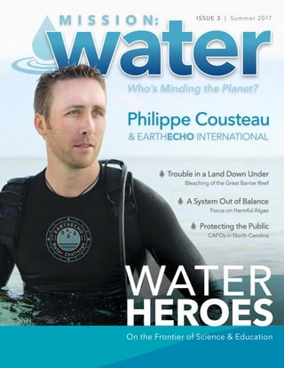
- 19. HEADLINE MISSION: WATER WATER HEROES 36 37 HEADLINE #WATERHEROES WATER HEROES Philippe and his wife Ashlan on expedition with their organization – EarthEcho International – energizing youth to change our planet. Photos Courtesy: EarthEcho International VOICE of WATERVOICE of WATER Q&A with Philippe Cousteau Philippe Cousteau has established himself as a prominent leader in the environmental movement. An award- winning television host, producer, author, speaker, philanthropist and social entrepreneur, Philippe is the son of Philippe Cousteau Sr. and grandson of Jacques Cousteau. His life-mission is to empower people to recognize their ability to change the world. Philippe is the host and executive producer of Xploration Awesome Planet, a new series that airs every Saturday morning syndicated on Fox and then Sunday free on Hulu. As a special correspondent for CNN he has hosted several award-winning shows including Going Green and Expedition Sumatra. In 2004 he founded EarthEcho International, a leading environmental education organization that is creating a whole new generation of environmental citizens - youth equipped with the knowledge to understand environmental challenges, critical thinking skills to solve them, and the motivation to do so. Discussing the Cousteau family legacy and empowering the next generation of environmental stewards. Filmmaker Explorer Teacher Water Hero Keynote Speaker Environmentalist Conservationist Entrepreneur TV Host Author Advocate F E A T U R E • S T O R Y MISSION: WATER STAFF ABOUT PHILIPPE
- 20. Photos Courtesy: EarthEcho International Philippe Cousteau Sr. MISSION: WATER38 HEADLINEWATER HEROES 39 HEADLINE #WATERHEROES WATER HEROES Q. Tying back to your family roots – what was it like growing up in a family of explorers? Philippe: My father passed away six months before I was born. So, there was both inspiration and some tragedy from an early age, but thank goodness I had my grandfather and my mother there to support me. My mother spent 13 years on expedition with my father. So, between the two of them, and my father's films and books, I was inspired. People may not remember, but [my father, Philippe Cousteau Sr.] filmed, produced, and directed 26 episodes of the series The Undersea World of Jacques Cousteau, which was popular at the time. He had his own award-winning series, Oasis in Space and was as much of a pioneer as my grandfather… he was the right hand to so much that [Jacques Cousteau] did. He led conservation efforts and was a global environmental advocate in his own right. So, I was in that environment growing up and it was a huge inspiration. I always like to say first and foremost, I believe my father and grandfather both left behind a legacy of problem-solving. People think of my grandfather as this tall, lanky, Frenchman - as a global visionary, and leader in conservation, an explorer, a filmmaker, and all of these things, and he certainly was all of those. But for me, he was a problem-solver. When he started out as a young man, he had no ambition to explore the oceans. His goal and ambition, initially, was to fly with the Naval Aviation Program. Unfortunately, he broke his back in a car accident, which I like to call the most fortuitous or luckiest car accident in history – both for the world because it eventually changed history by setting him on a different course, but also for me because all of the remaining members of his Naval Aviation class were killed in the early days of World War II. If it wasn't for that car accident, I literally wouldn't be here, so I'm grateful for it. And… the world would be a very different place because he was told to swim in the Mediterranean every day to rebuild his back strength. He was struck by this [undersea] world that he saw and a friend gave him a pair of homemade goggles to use. Those weren’t things you could go down to the store and buy back then. And he used those goggles to start freediving and he became frustrated that he couldn't spend more time underwater. Some people may forget the only way we could explore the oceans in the early 1900’s was through hard helmet diving that you see in the old Jules Verne movies…or through freediving. That was a problem [for Jacques] so he sought a way to solve it. To make a long story short, he met an engineer and they co- invented scuba diving as we know it today. Then he wanted to figure out ways to film what he was seeing underwater to share the experience with others, so together they figured out ways to create underwater cameras. So, every step along the way, there was a problem that he sought to solve. Eventually, over the course of a decade or more of diving and exploring the Mediterranean, he saw all of these aquatic environments for the first time and he was the first to show it to the world. At this point in time, most people knew very little about the ocean. They only knew what we pulled out of it and ate, and the trash we'd dumped into it. Over the course of a decade or so, [my grandfather] witnessed a precipitous decline in the health of the environment. In the Mediterranean, in particular, the population explosion post-World War II and corresponding trash, waste, and overfishing threatened the ocean. It was shocking. His thinking evolved from exploring the oceans to recognizing he had a responsibility to protect them. So that's it...it's a long answer, but it kind of gives a little bit of context to our family’s thinking and how I grew up. A young Philippe Cousteau Sr.with his father, Jacques. Q. At what point, as a kid, did you start to realize you were part of something bigger? Was there a turning point where you said, "I want my life to focus on advocating for the environment”? Philippe: Yeah. Well, the best part of my job is that I'm able to travel, see the world, explore, and learn new things. And it really goes back to when I was about 16 years old and I had an opportunity to go on an expedition to Papua New Guinea. I was in the southeastern part of the island, diving on a liveaboard with a researcher, Dr. Eugenie Clark, for two weeks. The trip was just spectacular. Here we were in this incredible, remote part of the world and we were doing research on a couple of new fish species that Eugenie had discovered. And I was thinking to myself, "My God, you can make a living doing this. You're traveling and you're seeing these amazing places- why would I want to do anything else?" That was the turning point for me. I was hooked. Q. Once you started to show interest in that side of your family's life, did they encourage you to keep going? Philippe: Well, my grandfather passed away when I was 17, a little less than a year after that experience in Papua New Guinea. And so he was certainly an important part of the inspiration leading up to that point, but by then it was my mother who encouraged me to keep moving forward in this world. She inspired me and pushed me forward to pursue my dreams. We had family, friends and people who'd known my father and grandfather and they provided opportunities for me to start getting involved in research. But, I went off to university and it wasn't until I got out of school and moved to Florida to work with an oceanographic institution that I got back on this path. I knew I needed to do something to honor this legacy and that’s when EarthEcho was born. Q. Tell me a little bit more about EarthEcho and how it's different from other environmental organizations. Philippe: From its inception, EarthEcho was a response to a problem. I looked around at the environmental movement and realized there was already a duplication of effort. There were many groups out there focused on conservation. And, in many ways, we're not really a conservation organization. While that’s an essential tenet to EarthEcho, we're more of an environmental education organization. There were a lot of conservation groups out there doing good work, but few offered a strategy for youth. If you look at the big NGOs (non-government organizations) like the WWF or the Ocean Conservancy, they have virtually no youth strategy to speak of. And that was a problem for me and I recognized it was a need. We don't like to duplicate effort, that's a very important part of the organization, and our philosophy, and our culture. Without a youth strategy, I don’t believe the environmental movement has a strategy. My grandfather was a big proponent of young people and recognized they are truly the trendsetters of society and have tremendous influence on the corporate world and even their parents. EarthEcho is unique because we leverage the history and the connection with the Cousteau legacy, but drive change by youth engagement. A young Philippe Cousteau Jr. with his grandfather, Jacques-Yves Cousteau.
- 21. thewaterinstitute.org MISSION: WATER40 HEADLINEWATER HEROES 41 HEADLINE #WATERHEROES WATER HEROES EarthEcho Water Challenge educates on the fundamentals of water testing. EarthEcho Water Challenge is the largestwater quality program of its kind. EarthEcho's central philosophy: "Action leads to awareness." Photos Courtesy: EarthEcho International Q. Can you speak to how EarthEcho empowers youth specifically? And what strategies you've used to get more buy-in from the younger population? Philippe: Yeah, we've evolved over the last 14 years, of course, just as technology and society has. I see organizations doing pretty much the same thing they were 30 years ago, and I think that that's an impediment to being effective. It's hard to change. It's hard to grow and it's hard to look at new technologies. There weren't any smartphones 14 years ago when we founded EarthEcho. We've seen a huge evolution in society in how young people communicate, from video games to mobile devices. You have to keep up and look for new ways to engage with them. Also, I think that what else sets us apart is that we're not a purely educational organization either. Our mission, our goal, is to engage people with action. We have a saying at EarthEcho, "awareness doesn't lead to action, action leads to awareness." We start with the idea of getting people engaged and getting them outdoors. The EarthEcho Water Challenge is a perfect example of this. It's a program that we're really excited about. It was developed initially by the EPA around 15 years ago and has continued to evolve over the years. Other groups like the Water Environment Federation, WEF, took it over from the EPA for a couple of years and then they were seeking another partner that was more youth-focused to take over, and they chose us. We were quite honored to be able to inherit that program two years ago, and it's a perfect example of action leading to awareness. We get people outdoors in their own communities, connecting with water, which is our most precious substance. They begin to understand where that water comes from and how it’s tested. It’s the beginning of a powerful conversation, which is symbolic of what EarthEcho is all about. That conversation is a jumping off point to people thinking more critically about what's happening in the environment over the long-term. Q. What’s your vision for the challenge moving forward? Philippe: Well, as soon as we took over [the Water Challenge program], we spent a lot of time and resources updating the logistics of the program and how we could digitize and streamline how we communicate to participants. There was a lot of behind-the-scenes work and investment to bring us to where we are today. That continuous improvement is a big part of our strategy moving forward. We also want to emphasize the action component of the challenge. Now that participants have personally tested the water and see the results, what are they going to do? Will they run cleanup projects, lobby for legislation, or seek funding? How will they improve or protect the water in their own community? There are all sorts of different ways that people can get involved. Also worth mentioning, is expanding the different water quality parameters that we can test for. We're hearing back from many of our partners that the tests we have currently are a terrific starting point, but they're interested in collecting data on phosphates and nitrogen. But why stop there? Can we look at nutrient loads in a water system that have a huge impact on our water? Eventually, could we build a program to test for things like E.coli and other indicators of water health? Ultimately, our goal is to make the EarthEcho Water Challenge the premiere water quality program, and I believe in many ways it already is. It's the largest global program of its kind, but we're never satisfied. We want to continue to grow it to meet the diverse needs of each community around the world. Q. What lessons have you learned from both your grandfather and father to fuel the work you do today? Philippe: One very important lesson is that tenacity is a virtue. Most people read the glorious headlines and saw all the accomplishments of my grandfather; all the films, and the success stories, and all his other projects. What you don't hear about are the struggles; how difficult it was to raise money for a nonprofit to do films and to do all the hard work that went into them. There were constant challenges he had to overcome, but he made it look easy. Growing up with those stories, I recognized early on that you can’t give up when things get difficult. Just a few years ago, the financial crisis took the rug out from under everyone. Yet, nonprofits didn't get a bailout, even though the nonprofit industry [in the U.S] is the backbone of our society and employs more people than financial services and auto industries combined. It was a difficult time. When the economy suffers, charity suffers. Overcoming those types of challenges – many of which you have no control over, but threaten everything you've built – are a key to success. Q. How do you think your television shows and outreach in the media have affected your conservation efforts and helped further your mission? Philippe: In the media space, we have an opportunity to continue to be outside and involved in fieldwork. As an advocate for sustainability and the environment, it's really important to get out and into the thick of it. You can't be an armchair conservationist. To speak to an issue and be passionate about it, you have to see it, touch it, and feel it, in person. The filmmaking and other related work allows me to do that, while also providing the added benefit of providing a platform to share those stories and experiences with millions. We have many different shows and programs and they're all designed to inspire people, to engage them, and to keep them asking questions about the world around them. To honor this legacy and that’s when EarthEcho was born. Without a youth strategy, I don't think the environmental movement has a strategy.
- 22. MISSION: WATER42 HEADLINEWATER HEROES HEADLINE #WATERHEROES 43 WATER HEROES Philippe and Ashlan challenge young people to be engaged in the world around them, remain open- minded, and be flexible. Photos Courtesy: EarthEcho International I could cut my leg off - I'd still probably survive, but not very well, and that's what we're doing to the ocean. It's the life support system of this planet... we've been destroying it for decades, and we're essentially maiming ourselves. Q. Has there been a moment or a special experience during your filming that stands out above all others? Philippe: A big part of what we do is connecting the dots. We help people understand that human beings are intimately connected to the environment. My father and grandfather always said, "You can't build environmental sustainability without human sustainability." There are so many different things that come to mind, but one that really impacted me was in Haiti. I was doing a special for CNN and for 10 days we examined local communities and how they were transforming themselves with hopeful and engaging work around solving the problems that they faced there, which are myriad and daunting, to say the least. One community, in particular, was in a place called Cité Soleil, which in French, means the City of Sun. It's the largest slum in the western hemisphere, located in Port-au-Prince. There are a few hundred thousand people living there in a shantytown of shacks and tents, dealing with extreme poverty, pollution, crime, gangs, etc. And in the middle of this, in the middle of this place, there's a program called The Jaden Tap Tap, which is a beautiful community garden. The gentleman who started this program, created an oasis – a Garden of Eden – in the middle of this port. His purpose is to help kids and community members grow fresh vegetables, so they can get proper nutrition with healthy food. He also built a place where kids could come and play soccer (football) in a safe place, away from gangs. It was truly a paradise in the middle of one of the worst slums in the world. That moment reminded me that connecting people to nature, particularly young people, can transform lives. It was an impactful experience to see people striving amidst truly daunting circumstances. Q. What is your advice for young people thinking about following in your footsteps as a conservationist? Philippe: No matter what you're interested in, ask questions, and always be interested and engaged in the world around you. Remain open-minded and inclusive because that allows you to learn, grow, and to change your opinion. I think that's one of the big problems we face today. People are so rigid in their ideology and thinking that they're unwilling to engage with others that don't necessarily share their views. My other practical advice is to study communications. I always tell young people that – whether you want to become a doctor, scientist, an explorer, or a lumberjack – through the course of your education you should understand how to better communicate with people. Take a public speaking class. Take a class in communications because those are the types of tools that will last a lifetime, and they're practical skills that a lot of young people today aren't getting. I was just speaking with some kids studying marine biology, and while it's great to have all that information and all that knowledge, if you can't talk to people about your work, it doesn't do the world much good. You have to be able to communicate to people, and you have to be able to get others excited about your work, or else you’ll just be piling away a research paper up on the shelf somewhere in the library, which should not be the goal. Firing people up about these issues should always be the goal. Learn More: earthecho.org Xploration Awesome Planet, Season 4 Each week Philippe hosts a 30-minute riveting earth science documentary series that explores the most spectacular places – on the earth, inside the earth, and above the earth. > Saturday Mornings, FOX (Seasons 1-3 Available on Hulu) Caribbean Pirate Treasure Later this summer, join Philippe and Ashlan as they dive into maritime mysteries, explore pirate history and investigate the lore of lost treasures in the Caribbean. > Season 1 Premiers August 20th at 10:00pm, Travel Channel Check out Philippe’s upcoming TV shows on FOX, Hulu, and the Travel Network.
- 23. 44 HEADLINEWATER HEROES 45 HEADLINE #WATERHEROES WATER HEROES Photos Courtesy: EarthEcho International Decades before EarthEcho International existed, Philippe Cousteau Sr., award-winning filmmaker and son of legendary explorer Jacques-Yves Cousteau, believed in a world where “every single child can breathe fresh air, drink clean water, and walk on green grass under a blue sky.” This belief, along with others, about the importance of protection our planet for future generations became the guiding principles for his children Philippe Jr. and Alexandra. Tragically, in June of 1979, Philippe Sr. died in a seaplane accident in Lisbon, Portugal, leaving Philippe Sr.’s widow to keep the Cousteau legacy alive for their children. Jan Cousteau spent 13 years on expedition with her husband, providing her with insight and experiences to instill in their children – the same beliefs and passion that she and her husband shared for the planet. Growing up fantasizing about traveling on expeditions as their parents did spurred the siblings to establish EarthEcho International in their father’s memory. At its core, EarthEcho International is a nonprofit organization founded on the belief that youth have the power to change our planet. For more than a decade, the EarthEcho team, now led by 37-year old Philippe Jr., have worked with thousands of young people, educators, and youth leaders to support change through action. Today, all of the EarthEcho’s programs are designed to equip new generations of leaders and problem solvers to identify and tackle environmental challenges in their own communities and beyond: The EarthEcho Water Challenge is an international program that equips anyone to combat the global water crisis by starting in their own communities. Through the simple acts of testing their local water, sharing the results, and taking action to restore and protect their resource, anyone can play a critical role in ensuring the overall health of the environment. All living things - plants, animals, and human beings - require clean water. As users of water and citizens of planet Earth, we must take responsibility for our impact on water quality. Recognizing that education and awareness are important first steps toward action, we challenge you to test the quality of your waterways, share your findings, and protect our most precious resource. Philippe Cousteau, Jr. EarthEcho’s STEMExplore highlights relatable voices and exciting life experiences to make careers in Science, Technology, Engineering, and Math (STEM) come alive. STEMExplore kindles youth interest in solving problems and becoming critical thinkers about the world around them. EarthEcho brings modern-day explorers and trailblazers to students and classrooms with a no-cost online destination, featuring dozens of relatable, day-in-the-life interviews with scientists and engineers from a variety of industries. EarthEcho’s Youth Leadership Council (YLC) is a platform for today’s emerging trailblazers and visionaries in the environmental space. Comprised of 19 diverse leaders from across the country, ages 15-22, each YLC member has demonstrated an ability to engage and mobilize their peers and their communities to change the world. Through EarthEcho’s platforms, YLC members are empowered to develop programs and conduct outreach to youth around the world. EarthEcho Expeditions is an annual program that brings the thrill of discovery to STEM classrooms by taking educators to the frontlines of our planet’s most pressing environmental issues in a new location each year. These teachers interact with leading experts who are solving or mitigating these complex issues. This first-hand experience with experts, thought leaders, and environmental advocates on the front lines is the basis for the creation of timely and exciting video and print- based classroom materials that are shared free of charge on EarthEcho’s digital platforms.
- 24. MISSION: WATER46 HEADLINELIFE TAKES WATER HEADLINE #WATERHEROES 47 LIFE TAKES WATER 70% of our planet is covered with water 97% 2% <1% is in the oceans in the form of salt water is locked in ice caps and glaciers is freshwater for consumption needed by all living creatures, including plants and animals The idea of global water shortages may seem overwhelming and distant, but when a water crisis occurs—the value of clean water and healthy waterways becomes apparent. Xylem Watermark is proud to sponser the EarthEcho Water Challenge program. Many of us often take it for granted, but it is important to remember that water doesn’t just come from our tap. Our drinking water comes from SEVERAL SOURCES: it is up to us to better understand and protect our water resources. Safe drinking water is a privilege STREAMS GROUNDWATERLAKESRIVERS Life Takes WATER 143 76,790 Bodies of water tested (oceans, lakes, rivers, streams, etc) Countries 120,098 Water Quality Monitoring events 137,703 Water Quality Monitoring Kits distributed 1,499,068 Participants It provides drinking water to over 30 million people (2005-2016) 1OUT OF 3 Americans get their drinking water from a river SPENT ANNUALLY on U.S. river-related recreation and tourism 2.9MILLION Miles of rivers in the U.S. One of the largest drinking water sources in the United States, is the Lower Colorado River "We believe that all of us have a role to play in the fight for clean water and healthy waterways worldwide…and that the best place to start is in your own community. The EarthEcho Water Challenge is a program that can do just that – equip anyone to be an advocate for water resources. The Water Challenge is a water monitoring program that helps individuals, students, families, and organizations take the first step in creating positive change in their own communities." and is responsible for growing 90% of our nation’s winter vegetables.90% 2017it was named America’s Most Endangered River At EarthEcho International... BY THE NUMBERS EARTHECHO WATER CHALLENGE $ 97 BILLION Water in U.S. Communities Join Us: monitorwater.org
- 25. The Hrimfare af Ranrike, a former long distance sailing vessel with no engine emissions. Photos: Dr. Martin Hassellöv MISSION: WATER48 HEADLINEOCEAN & COASTAL WATERS 49Who’s Minding the Planet? HEADLINEOCEAN & COASTAL WATERS Sailing the Baltic Sea Measuring Environmental Effects of Shipping For several thousand years, the Baltic Sea has been an important resource for fishing and trade. The Vikings (800-1100 AC) established trade routes across the Baltic and travelled with their longships via rivers to the Caspian and Black Seas. Many of the Viking trade routes and locations were eventually taken over by the Hanseatic League, an association of independent cities that dominated trade and shipping in Northern Europe during the Middle Ages. Today other types of ships dominate the Baltic Sea - from ferries and cruise ships, to oil tankers, car carriers, container and other cargo ships. Up to 15% of the world’s cargo traffic is handled in the Baltic Sea, making it one of the busiest areas for ship traffic, in the world. Due to its narrow straights and shallow waters, the Baltic Sea is difficult to navigate. In some of the major ship lanes, like in the Bornholm straight between the Danish Island of Bornholm and the Swedish main land, there is one large ship passing every 10 minutes, on average. 1 The ever expanding shipping and tourism industries have led to growing environmental pressure on the waterway. This pressure manifests as increased air, water, and noise pollution, presenting a clear threat to the future of the Baltic. So much that the European Union (EU) launched a joint research and development program called BONUS in 2010, focused exclusively on developing a sustainable economic and ecological plan for commerce. BONUS is a collaboration of representatives from all EU members bordering this priceless resource and “…funds projects of high excellence and relevance to produce knowledge, scientific evidence and [innovative] solutions needed by policymakers…” 2 One such initiative is the SHEBA (Sustainable Shipping and Environment in the Baltic Sea region) project, which launched in April of 2015 and will continue until 2018. In the SHEBA project, environmental effects of shipping in the Baltic Sea region are in sharp focus. The project is supported by a wide range of stakeholders - from atmospheric and oceanographic scientists to economists and experts on shipping, environmental policies and law, who will be consulted about data collection and results of the project. Per BONUS, the project aims to “…provide a holistic assessment of [the] impacts of operational shipping on the environment…through [analysis] of the drivers for shipping and their impacts on ship traffic volumes and emission factors.” 3 1 Madjidian et al. 2013 2 bonusportal.org 3 sheba-project.eu Baltic Vessels of the Past Mankind has rich maritime history on the Baltic Sea. Kingdoms, merchant leagues, and empires were forged and lost on its waves. Different eras of history led to different naval designs, with some of the most famous designs firmly imprinted into our culture today. Long and slender Viking longships are some of the most easily recognizable ships on record. Taking cues from the Baltic’s past, Hrimfare af Ranrike’s name was inspired by Nordic mythology. It translates loosely to frost traveler of the sea, with “Hrim” meaning frost, “Fare” meaning travel and “Ranrike” signifying the kingdom of goddess of the sea (her name was Ran). BONUS Members Per BONUS, Eight EU (European Union) member states have supported the program with €100M in combined funding over the past 6 years. The Russian government also joins in the program via bilateral agreements. 2 RussiaPolandLatvia FinlandDenmark SwedenLithuania GermanyEstonia DR. ANDERS TENGBERG The project aims to...provide a holistic assessment of [the] impacts of operational shipping on the environment...