Carstairs Eskers Complex
•Download as PPTX, PDF•
0 likes•836 views

A more complete suite of slides is available on Flickr at http://www.flickr.com/photos/geojuice/sets/72157628719699499/ Getting really fed up with the uneven playing field so thinking of making them all into videos and using Vimeo as a more stable and realistic platform. Let me know what you think on Flickr. Now if the Guardian got rid of their stupid headers and footers.... Anyway enjoy this one if you are a geographer, geologist or just interested in our planet.

Recommended
More Related Content
Viewers also liked
Viewers also liked (20)
More from Alan Doherty
More from Alan Doherty (20)
Recently uploaded
Recently uploaded (20)
Editor's Notes
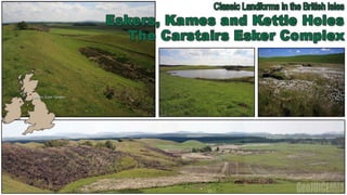
- Carstairs “Kames” is a classic site, long renowned for its glacial landforms. These comprise a series of esker ridges, kames and kettle holes, one of the best such assemblages in Britain formed by the meltwater (streams) of the last ice sheet as it decayed approximately 13,000 years ago.
- Although called “kames”, after the historical usage of this term, the landforms are in fact eskers, consisting of a series of sinuous ridges and mounds of sand and gravel with intervening kettle holes. (McKirdy, Gordon and Crofts, (2007) The trend of such landforms almost always records the direction of the last ice movement.There are very few examples of esker complexes available for study in Scotland. Why is this?
- This geomorh map can also be viewed as an economics landscape! The surface geology is relatively simple, consisting of glacifluvial (as it is now called!) sands and gravels and peat which lies on top of more glacifluvial sands and gravels. The last glaciation in this area saw ice advancing from west-south-west to east-north-east and then eventually retreating in the opposite direction.Because outwash is fairly well sorted and the particles are generally not chemically weathered, it is an excellent source of aggregate for building roadways and for mixing with cement to make concrete. Nb The Carstairs Esker Complex is part of a system which extends for 20 miles down the Douglas Valley, alongside the Clyde, and into the Medwin Valley.
- Farming practices have, on the whole, been beneficial to the conservation of the esker assemblage. The removal of woodland and scrub, which continues to this day, has certainly revealed the striking nature of this landscape. The economic importance of sand and gravel and also peat has led to the removal of large swathes of the esker complex.
- A large thickness of peat covers the low lying land of the Mouse Valley. This is Ryeflat Moss. The growth of peat began in the early Holocene, and it then expanded during the later wetter phases. Loss of woodland is thought to have contributed to increased leaching and surface wetness and therefore an increase in the growth of peat, particularly after 4,500 years ago.
- The former extent of esker systems in Scotland has been severely reduced by sand and gravel quarrying, especially in the Central Belt. This esker landscape, near the Lathallan roundabout, was available until about 1980. Polmont Golf Course was closed as part of its removal.
- Outwash or ablation landscapes can be identified by their hummocky relief. The landscape is often “pitted” with dead ice features known as kettle holes. Another feature to note on the map is the contrasting directions between the present day drainage pattern and the late glacial drainage pattern of 15,000 years ago.
- As the Southern Upland Ice receded to the south west so the Highland ice melted back towards the northwest. The lower Clyde Valley was still blocked by ice. Only after the lower Clyde became ice free did the drainage resume a north west route along the Clyde Valley.The proof? 1. Map analysis on a regional scale can trace the same outwash features to the Pentlands.2. 95% 0f the cobble and boulder content of the outwash material originated in the Southern Uplands.3. As the Highland ice retreated towards the north-west, lakes were dammed in the middle and lower Clyde Valley (“Lake Clydesdale”) and in the valleys of the River Kelvin and the Avon Water.
- Although called “kames”, after the historical usage of this term, the landforms are in fact eskers, consisting of a series of sinuous ridges and mounds of sand and gravel with intervening kettle holes. (McKirdy, Gordon and Crofts, (2007)Eskers are formed from the deposition of sediments by meltwater. Sediment transported by meltwater can be deposited either in contact with the glacier (supraglacial, englacial or subglacial environments), or the sediment may be deposited beyond the ice front in the proglacial environment (as part of the outwash plain).Eskers are sinuous, sometimes discontinuous, ridges formed of sand, gravel or boulders. Eskers may form single ridges of interconnected networks.There are two eskers in this photograph. They may have been contemporaneous or they may indicate a change of course of the meltwater stream. If a tunnel is abandoned then the esker will be able to survive as long as the glacier does not remove it.
- Most eskers are subglacial in origin but supraglacialmeltwater streams will obviously also create eskers if any deposition occurs while the stream is flowing along the top of the glacier ice.Eskers form only when stream velocity is falling, e.g. following the early summer meltwater discharge peak.
- Deposition is generally sorted and graded. Spring meltwater generally re-energises the flow and seasonal patterns can often be distinguished. The initial deposits at the base of the esker often consist of the coarsest material.
- Usually the outwash materials are clearly stratified, with rapidly-alternating layers of sand and gravel of various grades reflecting the constantly changing conditions of flow of the glacial rivers. What we see is the last resting place of the meltwater borne material. This last resting place will undoubtedly be associated with stagnant ice. Indeed the deposit itself may have initially been laid down on top of stagnant ice.The middle image is from an esker at Lathallan, West Lothian. Note the CROSS-BEDDING. This suggests deposition in a sediment bar in the middle of a river or perhaps a deltaic environment.The left hand image is from the snout of Skaftafelljökull. A cobbled stream bed which has been deposited on top of stagnant ice.The RH image shows current bedding from a lacustrine deposit.
- Kettles are glacifluvial landforms – subsidence hollows occurring as the result of blocks of ice calving from the front of a receding glacier and becoming partially or wholly buried by glacial outwash. When the ice blocks eventually melt they leave behind holes or depressions that fill with water to become kettle hole lakes. In freshly glaciated areas, kettles form obvious small lakes in the outwash plains. In areas glaciated in historic times they may be preserved as isolated small lakes, or deep water filled depressions in boggy areas that were covered in outwash sands and gravels.
- A partially uncovered kame northwest of Lanark. Kames are irregularly shaped mounds or hills, composed mainly of sand and gravel that accumulates in a depression on a retreating glacier, and is then deposited on the land surface, with further melting of the glacier. Kames can be pitted by the melting of buried ice which forms subsidence hollows called kettles. Kame and kettle topography is common on the outwash plains of retreating ice sheets.Kames are really ice disintegration features, formed in ice marginal, subglacial, or supraglacial situations wherever cavities happen to be available.
- Only kame mounds and kameplateaux are found in the Carstairs Esker Complex. In all cases they are secondary features to the eskers.
- The exact origin of these landforms remains a matter of debate, particularly whether the eskers formed in tunnels under the ice or in open, ice-walled channels.