The grand Ethiopian Renaissance dam (eg)
•
6 likes•3,972 views

The grand Ethiopian Renaissance dam , Location , Design and Type , Structure , power station , Geology and Environment , Environmental Impact .

Recommended
More Related Content
What's hot
What's hot (20)
Similar to The grand Ethiopian Renaissance dam (eg)
Similar to The grand Ethiopian Renaissance dam (eg) (20)
More from Amr Elgabri
Recently uploaded
Recently uploaded (20)
The grand Ethiopian Renaissance dam (eg)
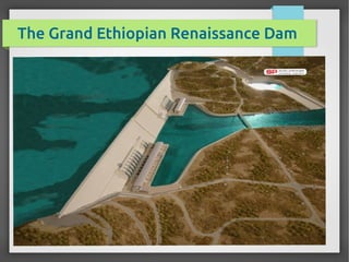
- 1. The Grand Ethiopian Renaissance Dam
- 2. Location l Formerly called as project x then known as the Millennium Dam then it renamed to Grand Ethiopian Renaissance Dam. l located on the Blue Nile River in Ethiopia . l It is in the Benishangul-Gumuz Region of Ethiopia, about 15 km east of the border with Sudan. l Coordinates 11°12′55″N 35°05′35″E
- 3. Location
- 4. Design and Type l Gravity dam , 175 m tall, 1,800 m long and composed of roller-compacted concrete. The structural volume of the dam will be 10,000,000 m3 with a construction cost of $6.4 billion USD .
- 5. Design and Type l Reservoir will have a storage capacity of 74 billion m3 and surface area of 1,561 km2 . l The dam will have three spillways, the main one is located to the left of the dam and will be controlled by six sector gates and have a design discharge of 15,000 l m3/s
- 6. Design and Type l Supporting the dam and reservoir will be a 5 km long and 50 m high rock-fill saddle dam. To the right of the saddle dam will be a third spillway for emergencies.
- 7. Design and Type l The dam will be capable of handling a flood of 19,370 cubic meters per second
- 8. Power station l At 6,000 MW, the dam will be the largest hydroelectric power plant in Africa when completed, as well as the 7th largest in the world. ( Hofer Dam 2000 MW)
- 9. Power station l The power stations are positioned on the right and left banks of the river and estimated production of 15,000 GWh per year. l A major benefit of the dam will be hydropower production. The electricity to be produced by the hydropower plant is to be sold in Ethiopia and to neighboring countries .
- 10. Geology and Environment l The Nile river l Blue Nile l Head water : lake Tana , high lands ,steep george l White Nile l lake vectoria , equitorial lake , swamps
- 11. Geology and Environment l The Nile water that Egypt relies on comes from two sources. The first, and most important, is the Ethiopian Plateau, which supplies the country with nearly 85 per cent of its needs only during the summer months, July to October. Some 65 per cent of these come from the Blue Nile (BN), and the remaining 20 per cent comes from the Atbara River.
- 12. Geology and Environment l The second source that compensates the rest of the year is the Great Lakes region of Africa, which provides about 15 per cent of Egypt’s needs. l The dam lies over an area which is dominated by per- camberian metamorphic rocks ( similar to red sea mountains in formation ).* l * arabic wiki
- 13. Environmental Impact l Flow Stream Scenarios the time periods needed to fill the reservoir of 74 BCM with water level 146 m, times needed are 37, 14.8, 7.4 and 3.7 BCM/year respectively. These results refer to a significant problem coming with charging the reservoir even at a long period time such as 40 years. The effects of charging time sceneries of the reservoir on Egyptian water demand were studied. The results showed that a sever water shortage problem will affect Egypt even with using the storage water in Nasser Lake The results referred to a significant problem coming with charging the reservoir even at a long period time such as 40 years. * HYDROLOGICAL AND ENVIRONMENTAL IMPACTS OF GRANDETHIOPIAN RENAISSANCE DAM ON THE NILE RIVER by Abdelkader T. Ahmed and Mohamed Helmy Elsanabary
- 14. Environmental Impact l Damage Scenario l In case of dam breach, a severe flood will result in inundation of the Senner dam with 15 km width and 200 km long and the areas in between until it reaches Khartoum. Also, excessive water level rise with 3 m is expected from the dam until it reaches Nasser Lake.
- 15. Environmental Impact With the huge reservoir scenario of 79 BCM, 122,000 people will be displaced and 7 million tons of CO2 emissions. The agricultural lands and scattering millions of families will be affected due to the reduction in the water share of downstream countries especially in Egypt.
- 16. Recommendation l Nile river countries should work together in order to find a compromise solutions and to prevent many hazards which may lead to sever damages .
- 18. Best regards , Amr Elgabri linkedin.com/in/amrelgabry amrelgabry@gstd.sci.cu.edu.eg gabora2004@gmail.com