SlideShare a Scribd company logo
1 of 56
Solving the Mystery of
January 23, 2013
Geographies


Presenters
         Caitlin Flint            Join in on Twitter
         Design Analyst           @HealthyCityCA
         cflint@advanceproj.org   #geoMystery

         JuHyun Yoo               General questions
         Research Analyst         info@healthycity.org
         jyoo@advanceproj.org
Healthy City is a program of
  Advancement Project is a multi-racial civil rights
  organization using innovative tools and strategies to
  strengthen social movements and impact policy change.


Offices in Los Angeles, Sacramento, Wash. D.C
Purpose
Communities of every race and class have the
opportunities and resources they need to thrive

Mission
Healthy City transforms how decisions are made by
creating innovative tools and methods that expose and
resolve structural inequities
…is about finding strategic solutions to support your work

ONLINE MAPPING TECHNOLOGY         DIRECT TECHNICAL ASSISTANCE:
    www.HealthyCity.org
                                     Work ON-THE-GROUND to
                                  develop targeted research/policy
                                     strategies and web tools.


                                    COMMUNITY RESEARCH LAB
                                 Engages, trains, and provides tools for
                                 community groups to lead and sustain
                                       action-oriented research
Agenda

Three Ways to Use Geographies on HC.org

Knowledge in Basic Census Geographies

How to choose geographies for your map
Three Ways to Use Geographies on HC.org
• Map Geography
• Data Geography
• Area Boundary
Three Ways to Use Geographies on
HC.org
1
                                   3


2
1 Map Geography
  Select the geographic area
  you want to map.
                               3 Area Boundary
                                 Select the area boundary
                                 you want to overlay on top
                                 of your map.

2 Data Geography
  Select the geographic unit
  of data you want to map.


                               Three Ways to Use Geographies on HC.org
1 Map Geography      Select the geographic area you
  want to map.

                             Change the geographic area by
                  Change
                             selecting from the list.


                           Three Ways to Use Geographies on HC.org
1 Map Geography      Select the geographic area you
  want to map.


                  Compar     Add another geographic area to
                    e        compare two geographic areas.


                             Draw your own boundary using
                   Draw      existing boundaries or by
                             drawing from scratch.


                           Three Ways to Use Geographies on HC.org
1 Map Geography   Select the geographic area you
  want to map.


                     Three Ways to Use Geographies on HC.org
2 Data Geography                  Select the geographic unit of data you
    want to map.


          Check which geographic units are available for the data you are
 Check    mapping.


          Select the geographic unit of data you want to map.
 Select


                                             Three Ways to Use Geographies on HC.org
2 Data Geography   Select the geographic unit of data you
   want to map.


                             Three Ways to Use Geographies on HC.org
2 Data Geography   Select the geographic unit of data you
   want to map.


                             Three Ways to Use Geographies on HC.org
2 Data Geography   Select the geographic unit of data you
   want to map.


                             Three Ways to Use Geographies on HC.org
3 Area Boundary Select the area boundary you want to overlay on top of
    your map.


  Match    Match the overlay boundary to data
           geography.


  Orient   Orient yourself within the mapped
           area.


                                               Three Ways to Use Geographies on HC.org
3 Area Boundary Select the area boundary you want to overlay on top of
    your map.


                                        Three Ways to Use Geographies on HC.org
3 Area Boundary Select the area boundary you want to overlay on top of
    your map.


                                        Three Ways to Use Geographies on HC.org
3 Area Boundary Select the area boundary you want to overlay on top of
    your map.


                                        Three Ways to Use Geographies on HC.org
Knowledge in Basic Census Geographies
• Census Geographies – Political Areas and Statistical Areas
• Hierarchy of Basic Census Geographies
• ZIP Codes? ZCTA?


                                    Knowledge in Basic Census Geographies
Political Areas and Statistical Areas


Political Areas                  Statistical Areas


• For administrative purposes    • For statistical and data-reporting
• Identified by public easily    purposes
• Can be complicated for data-   • Artificially Created
reporting and analysis           • Harder to be recognized by public


                                        Knowledge in Basic Census Geographies
Hierarchy of Basic Census Statistical Geography
Diagram adopted and edited from Urban Policy and the Census (2011) by H. MacDonald and A.
Peters


             • The basis of most Census Boundaries.
  Block
             • Boundaries are drawn based on city
             blocks.


             • In average, 39 blocks make up a block
 Block
 Group       group.
             • 600~3,000 people per block group.
             (Optimum size=1,500 people)


             • 1,500 ~ 8,000 people (Optimum size = 4,000 people)
  Tract      • Smaller area size of tracts = higher population density
             • Designed to represent homogeneous population characteristics,
             economic status, and living conditions.


                                                                               Knowledge in Basic Census Geographies
Smaller area size of tracts = higher population density


                                                Knowledge in Basic Census Geographies
Hierarchy of Basic Census Statistical Geography
Example: Advancement Project (1910 W. Sunset Blvd. Suite 500 Los Angeles, CA 90020)


                                                                              Knowledge in Basic Census Geographies
ZIP Code? ZCTA?


        • ZIP = Zone Improvement Plan
        • Created by United States Postal Service (USPS) to make mail
  ZIP
 Code   sorting and delivery more efficient.
        • Updated as needed, which is more frequent than the update cycle
        of Census geographies.


        • ZCTA = ZIP Code Tabulation Area
        • Created by the U.S. Census Bureau
 ZCTA   • Generalized the ZIP Code boundaries to summarize data by
        more recognizable geographic units.
        • Updated every ten years.


                                         Knowledge in Basic Census Geographies
Questions?
How to choose geographies for your
map
Consider your data
Consider your audience
Use local knowledge
Explore


                                How To Choose A Boundary
Consider your data

What kind of data are you mapping?
Example: First 5 LA Best Start Communities


                               How To Choose A Boundary: Consider your data
How To Choose A Boundary: Consider your data
Aggregation
Combining data from
smaller geographies
to create a larger
geography


                      How To Choose A Boundary: Consider your data
How To Choose A Boundary: Consider your data
Consider your audience

What geographies are they familiar with?
What geographies are they concerned with?
Example: SaveMySeatLA.org


                         How To Choose A Boundary: Consider your audience
How To Choose A Boundary: Consider your audience
Use local knowledge
Don’t discount personal experience

Rural areas—don’t want to use city/place
(insert screenshot with area city place actually covers)

Is there a park or industrial area nearby—might account for large
    gaps


                                 How To Choose A Boundary: Use local knowledge
All 1523 city/place boundaries
     Data at City/place level geography
     does not cover the entire state.


How To Choose A Boundary: Consider your audience
How To Choose A Boundary: Use local knowledge
Explore
What is most effective for your story?
What has the most meat?

Ex: if I want to understand what's happening in my city, city level
  data won’t tell the whole story.


                                                 How To Choose A Boundary
How To Choose A Boundary: Explore
How To Choose A Boundary
Remember…
Consider your data
Consider your audience
Use local knowledge
Explore


                         How To Choose A Boundary
Questions?


             How To Choose A Boundary
What we learned

Three Ways to Use Geographies on HC.org

Knowledge in Basic Census Geographies

How to choose geographies for your map


                                          The End.
Help is Available:
         Click on
• Healthy City User Guide
            or
          •FAQs
Thank You!

More Related Content

Viewers also liked

Claves para la implementacion de tendencias y enfoques carmen sofia prada
Claves para la implementacion de tendencias y enfoques  carmen sofia pradaClaves para la implementacion de tendencias y enfoques  carmen sofia prada
Claves para la implementacion de tendencias y enfoques carmen sofia pradaSANDRA SILVA
 
Salzburg Academy: Julian's presentation
Salzburg Academy: Julian's presentationSalzburg Academy: Julian's presentation
Salzburg Academy: Julian's presentationJulian McDougall
 
Religion is the opiate of the masses
Religion is the opiate of the massesReligion is the opiate of the masses
Religion is the opiate of the massesC
 
Ethiek (2)
Ethiek (2)Ethiek (2)
Ethiek (2)JH W
 
Telica Mission Trip
Telica Mission TripTelica Mission Trip
Telica Mission Tripmamafeenix
 
Aids Ahiv1
Aids Ahiv1Aids Ahiv1
Aids Ahiv1C
 
Cwex and apprenticeship credits 2012
Cwex and apprenticeship credits 2012Cwex and apprenticeship credits 2012
Cwex and apprenticeship credits 2012V
 
Inhauteriak power point
Inhauteriak power pointInhauteriak power point
Inhauteriak power pointaltzaeskola
 
052610 statewide partnership_mtg
052610 statewide partnership_mtg052610 statewide partnership_mtg
052610 statewide partnership_mtgHealthy City
 
Analizando oraciones
Analizando oracionesAnalizando oraciones
Analizando oracionesmaestra5b
 
Hands-on Training Merced-3.15.12
Hands-on Training Merced-3.15.12Hands-on Training Merced-3.15.12
Hands-on Training Merced-3.15.12Healthy City
 
Cedar Mill Oral History Project
Cedar Mill Oral History ProjectCedar Mill Oral History Project
Cedar Mill Oral History Projectsonofrich
 
100624 tube 8 no surf no glory (peter den held)
100624 tube 8   no surf no glory (peter den held)100624 tube 8   no surf no glory (peter den held)
100624 tube 8 no surf no glory (peter den held)KennisLAB
 
"Here Comes The Judge" - Should Christians Judge Others?
"Here Comes The Judge" - Should Christians Judge Others?"Here Comes The Judge" - Should Christians Judge Others?
"Here Comes The Judge" - Should Christians Judge Others?Don McClain
 

Viewers also liked (20)

Struktur kurikulum pbsi 2012
Struktur kurikulum pbsi 2012Struktur kurikulum pbsi 2012
Struktur kurikulum pbsi 2012
 
Claves para la implementacion de tendencias y enfoques carmen sofia prada
Claves para la implementacion de tendencias y enfoques  carmen sofia pradaClaves para la implementacion de tendencias y enfoques  carmen sofia prada
Claves para la implementacion de tendencias y enfoques carmen sofia prada
 
060114 ss
060114 ss060114 ss
060114 ss
 
Salzburg Academy: Julian's presentation
Salzburg Academy: Julian's presentationSalzburg Academy: Julian's presentation
Salzburg Academy: Julian's presentation
 
Religion is the opiate of the masses
Religion is the opiate of the massesReligion is the opiate of the masses
Religion is the opiate of the masses
 
Ethiek (2)
Ethiek (2)Ethiek (2)
Ethiek (2)
 
Historiaurrea
HistoriaurreaHistoriaurrea
Historiaurrea
 
Telica Mission Trip
Telica Mission TripTelica Mission Trip
Telica Mission Trip
 
Aids Ahiv1
Aids Ahiv1Aids Ahiv1
Aids Ahiv1
 
Cwex and apprenticeship credits 2012
Cwex and apprenticeship credits 2012Cwex and apprenticeship credits 2012
Cwex and apprenticeship credits 2012
 
Inhauteriak power point
Inhauteriak power pointInhauteriak power point
Inhauteriak power point
 
Car Cost Scan
Car Cost ScanCar Cost Scan
Car Cost Scan
 
Historiaurrea
HistoriaurreaHistoriaurrea
Historiaurrea
 
052610 statewide partnership_mtg
052610 statewide partnership_mtg052610 statewide partnership_mtg
052610 statewide partnership_mtg
 
Analizando oraciones
Analizando oracionesAnalizando oraciones
Analizando oraciones
 
Hands-on Training Merced-3.15.12
Hands-on Training Merced-3.15.12Hands-on Training Merced-3.15.12
Hands-on Training Merced-3.15.12
 
Cedar Mill Oral History Project
Cedar Mill Oral History ProjectCedar Mill Oral History Project
Cedar Mill Oral History Project
 
100624 tube 8 no surf no glory (peter den held)
100624 tube 8   no surf no glory (peter den held)100624 tube 8   no surf no glory (peter den held)
100624 tube 8 no surf no glory (peter den held)
 
Historiaurrea
HistoriaurreaHistoriaurrea
Historiaurrea
 
"Here Comes The Judge" - Should Christians Judge Others?
"Here Comes The Judge" - Should Christians Judge Others?"Here Comes The Judge" - Should Christians Judge Others?
"Here Comes The Judge" - Should Christians Judge Others?
 

Similar to Solving the Mystery of Geographies

An introduction to geographic information systems (gis) m goulbourne 2007
An introduction to geographic information systems (gis)   m goulbourne 2007An introduction to geographic information systems (gis)   m goulbourne 2007
An introduction to geographic information systems (gis) m goulbourne 2007Michelle Goulbourne @ DiaMind Health
 
Geographic information system (gis)
Geographic information system (gis)Geographic information system (gis)
Geographic information system (gis)Shailendra Singh
 
Beyond Dots on a Map: Spatially Modeled Surfaces of DHS data
Beyond Dots on a Map: Spatially Modeled Surfaces of DHS dataBeyond Dots on a Map: Spatially Modeled Surfaces of DHS data
Beyond Dots on a Map: Spatially Modeled Surfaces of DHS dataMEASURE Evaluation
 
Application of remote sensing,population identification
Application of remote sensing,population identificationApplication of remote sensing,population identification
Application of remote sensing,population identificationSATISH KUMAR
 
Crowdsourcing and Participation in Cartography (G572 Guest Lecture)
Crowdsourcing and Participation in Cartography (G572 Guest Lecture)Crowdsourcing and Participation in Cartography (G572 Guest Lecture)
Crowdsourcing and Participation in Cartography (G572 Guest Lecture)Carl Sack
 
What is GIS (Course Presentation).pdf
What is GIS (Course Presentation).pdfWhat is GIS (Course Presentation).pdf
What is GIS (Course Presentation).pdfjarriesgado
 
National Geologic Map Database Presentation
National Geologic Map Database PresentationNational Geologic Map Database Presentation
National Geologic Map Database PresentationAndrew Wagner
 
Presentation A.K Nigam sir (2) (1).pptx
Presentation A.K Nigam sir (2)  (1).pptxPresentation A.K Nigam sir (2)  (1).pptx
Presentation A.K Nigam sir (2) (1).pptxspeedcomcyber25
 
Hands-On Training Salinas 5-2-12 (Part I)
Hands-On Training Salinas 5-2-12 (Part I)Hands-On Training Salinas 5-2-12 (Part I)
Hands-On Training Salinas 5-2-12 (Part I)Healthy City
 
Space For Human Services Planning
Space For Human Services PlanningSpace For Human Services Planning
Space For Human Services PlanningBrian Cooper
 

Similar to Solving the Mystery of Geographies (20)

Sowo570
Sowo570 Sowo570
Sowo570
 
GIS in Health
GIS in HealthGIS in Health
GIS in Health
 
An introduction to geographic information systems (gis) m goulbourne 2007
An introduction to geographic information systems (gis)   m goulbourne 2007An introduction to geographic information systems (gis)   m goulbourne 2007
An introduction to geographic information systems (gis) m goulbourne 2007
 
Geographic information system (gis)
Geographic information system (gis)Geographic information system (gis)
Geographic information system (gis)
 
Beyond Dots on a Map: Spatially Modeled Surfaces of DHS data
Beyond Dots on a Map: Spatially Modeled Surfaces of DHS dataBeyond Dots on a Map: Spatially Modeled Surfaces of DHS data
Beyond Dots on a Map: Spatially Modeled Surfaces of DHS data
 
Intro_GIS.ppt
Intro_GIS.pptIntro_GIS.ppt
Intro_GIS.ppt
 
Introduction to GIS.pptx
Introduction to GIS.pptxIntroduction to GIS.pptx
Introduction to GIS.pptx
 
Vector.pdf
Vector.pdfVector.pdf
Vector.pdf
 
Application of remote sensing,population identification
Application of remote sensing,population identificationApplication of remote sensing,population identification
Application of remote sensing,population identification
 
Crowdsourcing and Participation in Cartography (G572 Guest Lecture)
Crowdsourcing and Participation in Cartography (G572 Guest Lecture)Crowdsourcing and Participation in Cartography (G572 Guest Lecture)
Crowdsourcing and Participation in Cartography (G572 Guest Lecture)
 
Map Making 101
Map Making 101Map Making 101
Map Making 101
 
Gis
GisGis
Gis
 
What is GIS (Course Presentation).pdf
What is GIS (Course Presentation).pdfWhat is GIS (Course Presentation).pdf
What is GIS (Course Presentation).pdf
 
National Geologic Map Database Presentation
National Geologic Map Database PresentationNational Geologic Map Database Presentation
National Geologic Map Database Presentation
 
STATISTICAL METHODS IN GEOGRAPHY
STATISTICAL METHODS IN GEOGRAPHYSTATISTICAL METHODS IN GEOGRAPHY
STATISTICAL METHODS IN GEOGRAPHY
 
Presentation A.K Nigam sir (2) (1).pptx
Presentation A.K Nigam sir (2)  (1).pptxPresentation A.K Nigam sir (2)  (1).pptx
Presentation A.K Nigam sir (2) (1).pptx
 
Gis dr rahul
Gis dr rahulGis dr rahul
Gis dr rahul
 
Hands-On Training Salinas 5-2-12 (Part I)
Hands-On Training Salinas 5-2-12 (Part I)Hands-On Training Salinas 5-2-12 (Part I)
Hands-On Training Salinas 5-2-12 (Part I)
 
Space For Human Services Planning
Space For Human Services PlanningSpace For Human Services Planning
Space For Human Services Planning
 
Gis
GisGis
Gis
 

More from Healthy City

Capturing and Sharing Your Story
Capturing and Sharing Your StoryCapturing and Sharing Your Story
Capturing and Sharing Your StoryHealthy City
 
Using Maps in Community-Based Research (3/12/15)
Using Maps in Community-Based Research (3/12/15)Using Maps in Community-Based Research (3/12/15)
Using Maps in Community-Based Research (3/12/15)Healthy City
 
Community Research Lab Workshops_2014_and 2015
Community Research Lab Workshops_2014_and 2015Community Research Lab Workshops_2014_and 2015
Community Research Lab Workshops_2014_and 2015Healthy City
 
Immigrant Health Paradox
Immigrant Health Paradox Immigrant Health Paradox
Immigrant Health Paradox Healthy City
 
Social Determinants of Health in Action
Social Determinants of Health in ActionSocial Determinants of Health in Action
Social Determinants of Health in ActionHealthy City
 
A Holistic Approach to Women s Health, Data and Mapping
A Holistic Approach to Women s Health, Data and MappingA Holistic Approach to Women s Health, Data and Mapping
A Holistic Approach to Women s Health, Data and MappingHealthy City
 
Grant Writing and Reporting
Grant Writing and ReportingGrant Writing and Reporting
Grant Writing and ReportingHealthy City
 
Uploading Your Own Data Onto v5
Uploading Your Own Data Onto v5Uploading Your Own Data Onto v5
Uploading Your Own Data Onto v5Healthy City
 
CRL STATEWIDE WORKSHOP SERIES
CRL STATEWIDE WORKSHOP SERIESCRL STATEWIDE WORKSHOP SERIES
CRL STATEWIDE WORKSHOP SERIESHealthy City
 
Youth Voices on a Map
Youth Voices on a MapYouth Voices on a Map
Youth Voices on a MapHealthy City
 
Supporting Abused and Neglected Children Through Early Care and Policy
Supporting Abused and Neglected Children Through Early Care and PolicySupporting Abused and Neglected Children Through Early Care and Policy
Supporting Abused and Neglected Children Through Early Care and PolicyHealthy City
 
Community assetsonamapwebinar finaltb
Community assetsonamapwebinar finaltbCommunity assetsonamapwebinar finaltb
Community assetsonamapwebinar finaltbHealthy City
 
Webinar 9.25 new tools_ final
Webinar 9.25 new tools_ finalWebinar 9.25 new tools_ final
Webinar 9.25 new tools_ finalHealthy City
 
Aca healthy citywebinar_final
Aca healthy citywebinar_finalAca healthy citywebinar_final
Aca healthy citywebinar_finalHealthy City
 
Using HealthyCity.org to upload your own data for planning and policy change
Using HealthyCity.org to upload your own data for planning and policy changeUsing HealthyCity.org to upload your own data for planning and policy change
Using HealthyCity.org to upload your own data for planning and policy changeHealthy City
 
6 25 2013 final using healthy_city org for early care education
6 25 2013 final using healthy_city org  for early care  education6 25 2013 final using healthy_city org  for early care  education
6 25 2013 final using healthy_city org for early care educationHealthy City
 
Demographic Analysis 5.28.2013
Demographic Analysis 5.28.2013Demographic Analysis 5.28.2013
Demographic Analysis 5.28.2013Healthy City
 
Is Information Power? Maps and Data for Community Change
Is Information Power? Maps and Data for Community ChangeIs Information Power? Maps and Data for Community Change
Is Information Power? Maps and Data for Community ChangeHealthy City
 
Solving the Mystery of Geographies (pdf)
Solving the Mystery of Geographies (pdf)Solving the Mystery of Geographies (pdf)
Solving the Mystery of Geographies (pdf)Healthy City
 
Healthy City Presentation_St.annes Family Based Services 7.11.12
Healthy City Presentation_St.annes Family Based Services 7.11.12Healthy City Presentation_St.annes Family Based Services 7.11.12
Healthy City Presentation_St.annes Family Based Services 7.11.12Healthy City
 

More from Healthy City (20)

Capturing and Sharing Your Story
Capturing and Sharing Your StoryCapturing and Sharing Your Story
Capturing and Sharing Your Story
 
Using Maps in Community-Based Research (3/12/15)
Using Maps in Community-Based Research (3/12/15)Using Maps in Community-Based Research (3/12/15)
Using Maps in Community-Based Research (3/12/15)
 
Community Research Lab Workshops_2014_and 2015
Community Research Lab Workshops_2014_and 2015Community Research Lab Workshops_2014_and 2015
Community Research Lab Workshops_2014_and 2015
 
Immigrant Health Paradox
Immigrant Health Paradox Immigrant Health Paradox
Immigrant Health Paradox
 
Social Determinants of Health in Action
Social Determinants of Health in ActionSocial Determinants of Health in Action
Social Determinants of Health in Action
 
A Holistic Approach to Women s Health, Data and Mapping
A Holistic Approach to Women s Health, Data and MappingA Holistic Approach to Women s Health, Data and Mapping
A Holistic Approach to Women s Health, Data and Mapping
 
Grant Writing and Reporting
Grant Writing and ReportingGrant Writing and Reporting
Grant Writing and Reporting
 
Uploading Your Own Data Onto v5
Uploading Your Own Data Onto v5Uploading Your Own Data Onto v5
Uploading Your Own Data Onto v5
 
CRL STATEWIDE WORKSHOP SERIES
CRL STATEWIDE WORKSHOP SERIESCRL STATEWIDE WORKSHOP SERIES
CRL STATEWIDE WORKSHOP SERIES
 
Youth Voices on a Map
Youth Voices on a MapYouth Voices on a Map
Youth Voices on a Map
 
Supporting Abused and Neglected Children Through Early Care and Policy
Supporting Abused and Neglected Children Through Early Care and PolicySupporting Abused and Neglected Children Through Early Care and Policy
Supporting Abused and Neglected Children Through Early Care and Policy
 
Community assetsonamapwebinar finaltb
Community assetsonamapwebinar finaltbCommunity assetsonamapwebinar finaltb
Community assetsonamapwebinar finaltb
 
Webinar 9.25 new tools_ final
Webinar 9.25 new tools_ finalWebinar 9.25 new tools_ final
Webinar 9.25 new tools_ final
 
Aca healthy citywebinar_final
Aca healthy citywebinar_finalAca healthy citywebinar_final
Aca healthy citywebinar_final
 
Using HealthyCity.org to upload your own data for planning and policy change
Using HealthyCity.org to upload your own data for planning and policy changeUsing HealthyCity.org to upload your own data for planning and policy change
Using HealthyCity.org to upload your own data for planning and policy change
 
6 25 2013 final using healthy_city org for early care education
6 25 2013 final using healthy_city org  for early care  education6 25 2013 final using healthy_city org  for early care  education
6 25 2013 final using healthy_city org for early care education
 
Demographic Analysis 5.28.2013
Demographic Analysis 5.28.2013Demographic Analysis 5.28.2013
Demographic Analysis 5.28.2013
 
Is Information Power? Maps and Data for Community Change
Is Information Power? Maps and Data for Community ChangeIs Information Power? Maps and Data for Community Change
Is Information Power? Maps and Data for Community Change
 
Solving the Mystery of Geographies (pdf)
Solving the Mystery of Geographies (pdf)Solving the Mystery of Geographies (pdf)
Solving the Mystery of Geographies (pdf)
 
Healthy City Presentation_St.annes Family Based Services 7.11.12
Healthy City Presentation_St.annes Family Based Services 7.11.12Healthy City Presentation_St.annes Family Based Services 7.11.12
Healthy City Presentation_St.annes Family Based Services 7.11.12
 

Recently uploaded

Training state-of-the-art general text embedding
Training state-of-the-art general text embeddingTraining state-of-the-art general text embedding
Training state-of-the-art general text embeddingZilliz
 
Moving Beyond Passwords: FIDO Paris Seminar.pdf
Moving Beyond Passwords: FIDO Paris Seminar.pdfMoving Beyond Passwords: FIDO Paris Seminar.pdf
Moving Beyond Passwords: FIDO Paris Seminar.pdfLoriGlavin3
 
SALESFORCE EDUCATION CLOUD | FEXLE SERVICES
SALESFORCE EDUCATION CLOUD | FEXLE SERVICESSALESFORCE EDUCATION CLOUD | FEXLE SERVICES
SALESFORCE EDUCATION CLOUD | FEXLE SERVICESmohitsingh558521
 
"ML in Production",Oleksandr Bagan
"ML in Production",Oleksandr Bagan"ML in Production",Oleksandr Bagan
"ML in Production",Oleksandr BaganFwdays
 
The State of Passkeys with FIDO Alliance.pptx
The State of Passkeys with FIDO Alliance.pptxThe State of Passkeys with FIDO Alliance.pptx
The State of Passkeys with FIDO Alliance.pptxLoriGlavin3
 
New from BookNet Canada for 2024: Loan Stars - Tech Forum 2024
New from BookNet Canada for 2024: Loan Stars - Tech Forum 2024New from BookNet Canada for 2024: Loan Stars - Tech Forum 2024
New from BookNet Canada for 2024: Loan Stars - Tech Forum 2024BookNet Canada
 
A Journey Into the Emotions of Software Developers
A Journey Into the Emotions of Software DevelopersA Journey Into the Emotions of Software Developers
A Journey Into the Emotions of Software DevelopersNicole Novielli
 
Rise of the Machines: Known As Drones...
Rise of the Machines: Known As Drones...Rise of the Machines: Known As Drones...
Rise of the Machines: Known As Drones...Rick Flair
 
Anypoint Exchange: It’s Not Just a Repo!
Anypoint Exchange: It’s Not Just a Repo!Anypoint Exchange: It’s Not Just a Repo!
Anypoint Exchange: It’s Not Just a Repo!Manik S Magar
 
Tampa BSides - Chef's Tour of Microsoft Security Adoption Framework (SAF)
Tampa BSides - Chef's Tour of Microsoft Security Adoption Framework (SAF)Tampa BSides - Chef's Tour of Microsoft Security Adoption Framework (SAF)
Tampa BSides - Chef's Tour of Microsoft Security Adoption Framework (SAF)Mark Simos
 
DevoxxFR 2024 Reproducible Builds with Apache Maven
DevoxxFR 2024 Reproducible Builds with Apache MavenDevoxxFR 2024 Reproducible Builds with Apache Maven
DevoxxFR 2024 Reproducible Builds with Apache MavenHervé Boutemy
 
Generative AI for Technical Writer or Information Developers
Generative AI for Technical Writer or Information DevelopersGenerative AI for Technical Writer or Information Developers
Generative AI for Technical Writer or Information DevelopersRaghuram Pandurangan
 
Passkey Providers and Enabling Portability: FIDO Paris Seminar.pptx
Passkey Providers and Enabling Portability: FIDO Paris Seminar.pptxPasskey Providers and Enabling Portability: FIDO Paris Seminar.pptx
Passkey Providers and Enabling Portability: FIDO Paris Seminar.pptxLoriGlavin3
 
What is DBT - The Ultimate Data Build Tool.pdf
What is DBT - The Ultimate Data Build Tool.pdfWhat is DBT - The Ultimate Data Build Tool.pdf
What is DBT - The Ultimate Data Build Tool.pdfMounikaPolabathina
 
New from BookNet Canada for 2024: BNC CataList - Tech Forum 2024
New from BookNet Canada for 2024: BNC CataList - Tech Forum 2024New from BookNet Canada for 2024: BNC CataList - Tech Forum 2024
New from BookNet Canada for 2024: BNC CataList - Tech Forum 2024BookNet Canada
 
A Deep Dive on Passkeys: FIDO Paris Seminar.pptx
A Deep Dive on Passkeys: FIDO Paris Seminar.pptxA Deep Dive on Passkeys: FIDO Paris Seminar.pptx
A Deep Dive on Passkeys: FIDO Paris Seminar.pptxLoriGlavin3
 
The Ultimate Guide to Choosing WordPress Pros and Cons
The Ultimate Guide to Choosing WordPress Pros and ConsThe Ultimate Guide to Choosing WordPress Pros and Cons
The Ultimate Guide to Choosing WordPress Pros and ConsPixlogix Infotech
 
Digital Identity is Under Attack: FIDO Paris Seminar.pptx
Digital Identity is Under Attack: FIDO Paris Seminar.pptxDigital Identity is Under Attack: FIDO Paris Seminar.pptx
Digital Identity is Under Attack: FIDO Paris Seminar.pptxLoriGlavin3
 
Time Series Foundation Models - current state and future directions
Time Series Foundation Models - current state and future directionsTime Series Foundation Models - current state and future directions
Time Series Foundation Models - current state and future directionsNathaniel Shimoni
 
The Role of FIDO in a Cyber Secure Netherlands: FIDO Paris Seminar.pptx
The Role of FIDO in a Cyber Secure Netherlands: FIDO Paris Seminar.pptxThe Role of FIDO in a Cyber Secure Netherlands: FIDO Paris Seminar.pptx
The Role of FIDO in a Cyber Secure Netherlands: FIDO Paris Seminar.pptxLoriGlavin3
 

Recently uploaded (20)

Training state-of-the-art general text embedding
Training state-of-the-art general text embeddingTraining state-of-the-art general text embedding
Training state-of-the-art general text embedding
 
Moving Beyond Passwords: FIDO Paris Seminar.pdf
Moving Beyond Passwords: FIDO Paris Seminar.pdfMoving Beyond Passwords: FIDO Paris Seminar.pdf
Moving Beyond Passwords: FIDO Paris Seminar.pdf
 
SALESFORCE EDUCATION CLOUD | FEXLE SERVICES
SALESFORCE EDUCATION CLOUD | FEXLE SERVICESSALESFORCE EDUCATION CLOUD | FEXLE SERVICES
SALESFORCE EDUCATION CLOUD | FEXLE SERVICES
 
"ML in Production",Oleksandr Bagan
"ML in Production",Oleksandr Bagan"ML in Production",Oleksandr Bagan
"ML in Production",Oleksandr Bagan
 
The State of Passkeys with FIDO Alliance.pptx
The State of Passkeys with FIDO Alliance.pptxThe State of Passkeys with FIDO Alliance.pptx
The State of Passkeys with FIDO Alliance.pptx
 
New from BookNet Canada for 2024: Loan Stars - Tech Forum 2024
New from BookNet Canada for 2024: Loan Stars - Tech Forum 2024New from BookNet Canada for 2024: Loan Stars - Tech Forum 2024
New from BookNet Canada for 2024: Loan Stars - Tech Forum 2024
 
A Journey Into the Emotions of Software Developers
A Journey Into the Emotions of Software DevelopersA Journey Into the Emotions of Software Developers
A Journey Into the Emotions of Software Developers
 
Rise of the Machines: Known As Drones...
Rise of the Machines: Known As Drones...Rise of the Machines: Known As Drones...
Rise of the Machines: Known As Drones...
 
Anypoint Exchange: It’s Not Just a Repo!
Anypoint Exchange: It’s Not Just a Repo!Anypoint Exchange: It’s Not Just a Repo!
Anypoint Exchange: It’s Not Just a Repo!
 
Tampa BSides - Chef's Tour of Microsoft Security Adoption Framework (SAF)
Tampa BSides - Chef's Tour of Microsoft Security Adoption Framework (SAF)Tampa BSides - Chef's Tour of Microsoft Security Adoption Framework (SAF)
Tampa BSides - Chef's Tour of Microsoft Security Adoption Framework (SAF)
 
DevoxxFR 2024 Reproducible Builds with Apache Maven
DevoxxFR 2024 Reproducible Builds with Apache MavenDevoxxFR 2024 Reproducible Builds with Apache Maven
DevoxxFR 2024 Reproducible Builds with Apache Maven
 
Generative AI for Technical Writer or Information Developers
Generative AI for Technical Writer or Information DevelopersGenerative AI for Technical Writer or Information Developers
Generative AI for Technical Writer or Information Developers
 
Passkey Providers and Enabling Portability: FIDO Paris Seminar.pptx
Passkey Providers and Enabling Portability: FIDO Paris Seminar.pptxPasskey Providers and Enabling Portability: FIDO Paris Seminar.pptx
Passkey Providers and Enabling Portability: FIDO Paris Seminar.pptx
 
What is DBT - The Ultimate Data Build Tool.pdf
What is DBT - The Ultimate Data Build Tool.pdfWhat is DBT - The Ultimate Data Build Tool.pdf
What is DBT - The Ultimate Data Build Tool.pdf
 
New from BookNet Canada for 2024: BNC CataList - Tech Forum 2024
New from BookNet Canada for 2024: BNC CataList - Tech Forum 2024New from BookNet Canada for 2024: BNC CataList - Tech Forum 2024
New from BookNet Canada for 2024: BNC CataList - Tech Forum 2024
 
A Deep Dive on Passkeys: FIDO Paris Seminar.pptx
A Deep Dive on Passkeys: FIDO Paris Seminar.pptxA Deep Dive on Passkeys: FIDO Paris Seminar.pptx
A Deep Dive on Passkeys: FIDO Paris Seminar.pptx
 
The Ultimate Guide to Choosing WordPress Pros and Cons
The Ultimate Guide to Choosing WordPress Pros and ConsThe Ultimate Guide to Choosing WordPress Pros and Cons
The Ultimate Guide to Choosing WordPress Pros and Cons
 
Digital Identity is Under Attack: FIDO Paris Seminar.pptx
Digital Identity is Under Attack: FIDO Paris Seminar.pptxDigital Identity is Under Attack: FIDO Paris Seminar.pptx
Digital Identity is Under Attack: FIDO Paris Seminar.pptx
 
Time Series Foundation Models - current state and future directions
Time Series Foundation Models - current state and future directionsTime Series Foundation Models - current state and future directions
Time Series Foundation Models - current state and future directions
 
The Role of FIDO in a Cyber Secure Netherlands: FIDO Paris Seminar.pptx
The Role of FIDO in a Cyber Secure Netherlands: FIDO Paris Seminar.pptxThe Role of FIDO in a Cyber Secure Netherlands: FIDO Paris Seminar.pptx
The Role of FIDO in a Cyber Secure Netherlands: FIDO Paris Seminar.pptx
 

Solving the Mystery of Geographies

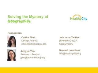
  • 1. Solving the Mystery of January 23, 2013 Geographies Presenters Caitlin Flint Join in on Twitter Design Analyst @HealthyCityCA cflint@advanceproj.org #geoMystery JuHyun Yoo General questions Research Analyst info@healthycity.org jyoo@advanceproj.org
  • 2. Healthy City is a program of Advancement Project is a multi-racial civil rights organization using innovative tools and strategies to strengthen social movements and impact policy change. Offices in Los Angeles, Sacramento, Wash. D.C
  • 3. Purpose Communities of every race and class have the opportunities and resources they need to thrive Mission Healthy City transforms how decisions are made by creating innovative tools and methods that expose and resolve structural inequities
  • 4. …is about finding strategic solutions to support your work ONLINE MAPPING TECHNOLOGY DIRECT TECHNICAL ASSISTANCE: www.HealthyCity.org Work ON-THE-GROUND to develop targeted research/policy strategies and web tools. COMMUNITY RESEARCH LAB Engages, trains, and provides tools for community groups to lead and sustain action-oriented research
  • 5.
  • 6. Agenda Three Ways to Use Geographies on HC.org Knowledge in Basic Census Geographies How to choose geographies for your map
  • 7. Three Ways to Use Geographies on HC.org • Map Geography • Data Geography • Area Boundary
  • 8. Three Ways to Use Geographies on HC.org 1 3 2
  • 9. 1 Map Geography Select the geographic area you want to map. 3 Area Boundary Select the area boundary you want to overlay on top of your map. 2 Data Geography Select the geographic unit of data you want to map. Three Ways to Use Geographies on HC.org
  • 10. 1 Map Geography Select the geographic area you want to map. Change the geographic area by Change selecting from the list. Three Ways to Use Geographies on HC.org
  • 11. 1 Map Geography Select the geographic area you want to map. Compar Add another geographic area to e compare two geographic areas. Draw your own boundary using Draw existing boundaries or by drawing from scratch. Three Ways to Use Geographies on HC.org
  • 12. 1 Map Geography Select the geographic area you want to map. Three Ways to Use Geographies on HC.org
  • 13. 2 Data Geography Select the geographic unit of data you want to map. Check which geographic units are available for the data you are Check mapping. Select the geographic unit of data you want to map. Select Three Ways to Use Geographies on HC.org
  • 14. 2 Data Geography Select the geographic unit of data you want to map. Three Ways to Use Geographies on HC.org
  • 15. 2 Data Geography Select the geographic unit of data you want to map. Three Ways to Use Geographies on HC.org
  • 16. 2 Data Geography Select the geographic unit of data you want to map. Three Ways to Use Geographies on HC.org
  • 17. 3 Area Boundary Select the area boundary you want to overlay on top of your map. Match Match the overlay boundary to data geography. Orient Orient yourself within the mapped area. Three Ways to Use Geographies on HC.org
  • 18. 3 Area Boundary Select the area boundary you want to overlay on top of your map. Three Ways to Use Geographies on HC.org
  • 19. 3 Area Boundary Select the area boundary you want to overlay on top of your map. Three Ways to Use Geographies on HC.org
  • 20. 3 Area Boundary Select the area boundary you want to overlay on top of your map. Three Ways to Use Geographies on HC.org
  • 21. Knowledge in Basic Census Geographies • Census Geographies – Political Areas and Statistical Areas • Hierarchy of Basic Census Geographies • ZIP Codes? ZCTA? Knowledge in Basic Census Geographies
  • 22. Political Areas and Statistical Areas Political Areas Statistical Areas • For administrative purposes • For statistical and data-reporting • Identified by public easily purposes • Can be complicated for data- • Artificially Created reporting and analysis • Harder to be recognized by public Knowledge in Basic Census Geographies
  • 23. Hierarchy of Basic Census Statistical Geography Diagram adopted and edited from Urban Policy and the Census (2011) by H. MacDonald and A. Peters • The basis of most Census Boundaries. Block • Boundaries are drawn based on city blocks. • In average, 39 blocks make up a block Block Group group. • 600~3,000 people per block group. (Optimum size=1,500 people) • 1,500 ~ 8,000 people (Optimum size = 4,000 people) Tract • Smaller area size of tracts = higher population density • Designed to represent homogeneous population characteristics, economic status, and living conditions. Knowledge in Basic Census Geographies
  • 24. Smaller area size of tracts = higher population density Knowledge in Basic Census Geographies
  • 25. Hierarchy of Basic Census Statistical Geography Example: Advancement Project (1910 W. Sunset Blvd. Suite 500 Los Angeles, CA 90020) Knowledge in Basic Census Geographies
  • 26. ZIP Code? ZCTA? • ZIP = Zone Improvement Plan • Created by United States Postal Service (USPS) to make mail ZIP Code sorting and delivery more efficient. • Updated as needed, which is more frequent than the update cycle of Census geographies. • ZCTA = ZIP Code Tabulation Area • Created by the U.S. Census Bureau ZCTA • Generalized the ZIP Code boundaries to summarize data by more recognizable geographic units. • Updated every ten years. Knowledge in Basic Census Geographies
  • 28. How to choose geographies for your map Consider your data Consider your audience Use local knowledge Explore How To Choose A Boundary
  • 29. Consider your data What kind of data are you mapping? Example: First 5 LA Best Start Communities How To Choose A Boundary: Consider your data
  • 30. How To Choose A Boundary: Consider your data
  • 31. Aggregation Combining data from smaller geographies to create a larger geography How To Choose A Boundary: Consider your data
  • 32. How To Choose A Boundary: Consider your data
  • 33. How To Choose A Boundary: Consider your data
  • 34. Consider your audience What geographies are they familiar with? What geographies are they concerned with? Example: SaveMySeatLA.org How To Choose A Boundary: Consider your audience
  • 35. How To Choose A Boundary: Consider your audience
  • 36. How To Choose A Boundary: Consider your audience
  • 37. How To Choose A Boundary: Consider your audience
  • 38. How To Choose A Boundary: Consider your audience
  • 39. Use local knowledge Don’t discount personal experience Rural areas—don’t want to use city/place (insert screenshot with area city place actually covers) Is there a park or industrial area nearby—might account for large gaps How To Choose A Boundary: Use local knowledge
  • 40. All 1523 city/place boundaries Data at City/place level geography does not cover the entire state. How To Choose A Boundary: Consider your audience
  • 41. How To Choose A Boundary: Use local knowledge
  • 42. How To Choose A Boundary: Use local knowledge
  • 43. How To Choose A Boundary: Use local knowledge
  • 44. Explore What is most effective for your story? What has the most meat? Ex: if I want to understand what's happening in my city, city level data won’t tell the whole story. How To Choose A Boundary
  • 45. How To Choose A Boundary: Explore
  • 46. How To Choose A Boundary: Explore
  • 47. How To Choose A Boundary: Explore
  • 48. How To Choose A Boundary
  • 49. Remember… Consider your data Consider your audience Use local knowledge Explore How To Choose A Boundary
  • 50. Questions? How To Choose A Boundary
  • 51. What we learned Three Ways to Use Geographies on HC.org Knowledge in Basic Census Geographies How to choose geographies for your map The End.
  • 52. Help is Available: Click on • Healthy City User Guide or •FAQs
  • 53.
  • 54.
  • 55.

Editor's Notes

  1. Innovation, multi-racial, integrated approach
  2. First 5 created Best Start community boundaries to Ex: Healthy City worked with First 5 to create custom boundaries—new geographies—tailored to the regions where they wanted to focus their efforts. The data they planned to explore in these areas was available at Census Blockgroup. As a result, in order to aggregate the data and map it to their new geographies, we helped First 5 construct their new geographies from Census Blockgroups.
  3. Definition of AggregationThe gray blocks on the left could be census blockgroups that are combined to find the total for a Congressional District, or ZIP Codes that are combined to find the total for the County.
  4. In this First 5 example, these Census Block Groups have been aggregated to create the new Broadway Manchester Boundary.Judging by the size of the blocks groups within their boundary, this is a good level of specificity for them to use as a tool in understanding their community.
  5. In this First 5 example, these Census Block Groups have been aggregated to create the new Broadway Manchester Boundary.
  6. Started with ZIP Code data because it is most recognizable to parent advocates or community members who want to generate support for early education.
  7. We also included maps of the data at district-level, because this is what is most important to elected officials.
  8. We also included maps of the data at district-level, because this is what is most important to elected officials.
  9. One problem with this plan is that even though our more general audience of parents and community members may not know their district, they will need to know it if they want to influence elected officials. To bridge this gap, we included a list of related geographies—so if someone viewing the map chooses a ZIP Code as the geography she wants to focus on, she gets district numbers as well by default.
  10. If you know you are interestedin a rural area, explore other options.
  11. Another example of when local knowledge and geographies go hand-in-hand is when you are interpreting and refining your map. Here, it looks like there is a shockingly low percentage of youth in my ZIP Code.
  12. CountyYou can adjust the data level to see varying levels of detail.
  13. Census Tract
  14. Census Block