A spatial analysis: creating similarity domains for targeted research sites in Zimbabwe. Andries Potgieter
•Download as PPTX, PDF•
2 likes•848 views

A presentation from the WCCA 2011 event held in Brisbane, Australia.

Recommended
Recommended
More Related Content
What's hot
What's hot (20)
Viewers also liked
Viewers also liked (16)
Similar to A spatial analysis: creating similarity domains for targeted research sites in Zimbabwe. Andries Potgieter
Similar to A spatial analysis: creating similarity domains for targeted research sites in Zimbabwe. Andries Potgieter (20)
More from Joanna Hicks
More from Joanna Hicks (20)
Recently uploaded
Recently uploaded (20)
A spatial analysis: creating similarity domains for targeted research sites in Zimbabwe. Andries Potgieter
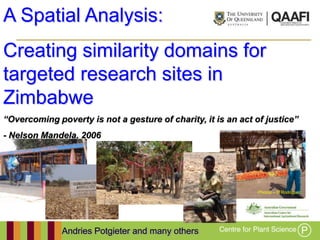
- 1. A Spatial Analysis: Creating similarity domains for targeted research sites in Zimbabwe “Overcoming poverty is not a gesture of charity, it is an act of justice” - Nelson Mandela, 2006 Photos – D Rodriguez Andries Potgieter and many others
- 2. Objective Aim: This spatial analysis has been commissioned by ACIAR to supply spatial data layers (including climate, production, market access and population) to develop similarity domains (on specifically climate and soil type) for research locations within the agricultural land-use of Zimbabwe. - To Enhance the uptake of targeted farming systems technologies - To Assist funding bodies and policy makers to target those regions that will have the highest impact from intervention and investment Risks & Uncertainties: - Lack of accurate agricultural information across temporal and spatial scales - Climate variability and change - Access to markets (input & output) - Political instability - High inflation
- 3. Did you know? - Area: 39 million ha (the size of Japan) flanked by RSA, Botswana, Mozambique and Zambia - Population: 13 million - Agriculture contributes 18% of GDP - Despite a 20% increase in area planted over the last year, 1.68 million people are currently in need food assistance (FAO 2011) NDVI AUC 1999,2000,2001 Inverse colours (blue low, red high)
- 4. Food Security Global Food Production 0.35 Global per capita harvested area [ ha person -1] Global cereal yields [kg ha-1] 3,000 0.25 2,000 1,000 0.15 source: Lui et al & FAO 1960 1970 1980 1990 2000 2010
- 5. 1000 1500 2000 2500 3000 0 500 1980/81 1981/82 1982/83 1983/84 1984/85 1985/86 1986/87 1987/88 1988/89 Food Security 1989/90 1990/91 Production (Tons ' 000) 1991/92 1992/93 Year 1993/94 1994/95 1995/96 1996/97 Zimbabwe: Maize production Area (Ha ' 000) 1997/98 1998/99 1999/00 2000/01 2001/02 2002/03 Yield (Kgs/ha) 2003/04 2004/05 2005/06 Funk & Brown 2010
- 6. Challenges Likely impact of climate change on maize yields for Africa Impact on maize yields by 2050 - Percent loss relative to 1990 (Schlenker and Lobell, 2009)
- 7. Food Security Security Zimbabwe: Food 20000 15000 10000 5000 0 94 95 96 97 98 99 00 01 02 03 04 05 06 19 19 19 19 19 19 20 20 20 20 20 20 20 -5000 -10000 -15000 Zimbabwe; Funk & Brown 2010 Population Yield (Kgs/ha) Prod ' 000 FII ' 000
- 8. Data • CLIMATE: Worldclim 1.4 database (http://www.worldclim.org/current) (Hijmans, Cameron et al. 2005) • SOIL: The SOTER soil database (Batjes 2004) • POPULATION: Population 2000 & 2005: SEDAC (http://sedac.ciesin.columbia.edu/gpw/global.jsp) • MARKET ACCESS: Cost distance grid for population greater than 10,000 (Kai Sonder and Gomez 2010) • LAND USE: Global land cover - GLC2000 (http://bioval.jrc.ec.europa.eu/products/glc2000/products.php) • CROP DISTRIBUTION: Gridded crop distributions (http://harvestchoice.org:8080/geonetwork/srv/en/main.home) • AGRICULTURAL POTENTIAL: Simulated maize yields (DSAT) from Jawoo Koo (IFPRI, http://harvestchoice.org)
- 9. Approach - Criteria for scaling out of locations to domains are (provided by CIMMYT): - Growing season rainfall (GSR) November to March (summer) - +/- 100mm precipitation in summer, - +/- 2o max temp (summer), - +/- 2o min temp (summer), - Soils: select similar soil classes of maximum rooting depth and soil texture to each location - Agricultural potential Simulated maize yields were generated using difference between Low Technology inputs (LI) (manure, manual labour etc.) and High Technology inputs (HI) (fertiliser, machinery etc.) - Overlaying of Climate and Soil layers where used to create the similarity domains while other data inputs where aggregated within each domain
- 10. Natural regions Final Site Locations - 3 sites moderate to high - 1 site moderate - 2 sites low NRs II and III account for around 84% of total maize production (FAO 2006)
- 11. Total Average Rainfall Average total Winter, Summer & Annual rainfall
- 12. Average Summer Temperatures Minimum (10oC – 24oC) Maximum (15oC – 35oC)
- 13. Soils Maximum rooting depth and Soil texture. % of Soil Ag Land use VS - 18% S - 8% M - 20% D - 39% VD - 13%
- 14. Domain Extraction Rainfall (mm) Temperature oC AN SM WT SM Max WT Max SM Min WT Min AN Max AN Min Gwanda 474 407 67 28 26 19 9 27 13 Gweru 630 568 62 27 24 18 10 25 13 Zimuto 647 575 72 26 24 18 8 25 12 Wedza 816 709 107 29 26 19 9 27 13 Madziwa 834 783 51 25 23 17 10 24 13 Bindura 902 830 72 27 25 18 9 26 13 Rootable Soil Market Avg Domain Population Location Depth (cm) Texture Access (hrs) travel time Area 2000 2005 Growth %Change Gwanda M CL 0 3.4 283,184 50,409 51,356 947 2 Bindura D CL 4 3.9 404,729 209,499 232,214 22,715 11 Wedza S LS 2 4.2 694,153 193,099 204,221 11,122 6 Madziwa M LS 3 4.5 870,442 330,721 363,542 32,821 10 Zimuto S LS 8 4.6 1,645,682 516,219 553,792 37,573 7 Gweru X S 4 4.3 1,696,315 536,207 589,658 53,451 10 Very shallow (VS); <30cm (18%), Shallow (S); 30 – 50cm (8%), Moderate deep (M); 50 – 100cm (20%), Deep (D); 100 – 150cm (39%) and Very deep (X); >150cm (13%)
- 15. Similarity Domains Gwanda Gweru Zimuto Madziwa Wedza Bindura
- 16. Agricultural Potential Low input (manure, manual labour etc.) High input (fertiliser, machinery etc.) • Currently actual 3-year avg DOMAIN yield < 1.75 t/ha (FAO) • Potential Yield Gap remains high across all regions However, farmers who applied good management e.g. buying and applying seeds and fertiliser in time, weeding and have access to hire machinery can get yields of more than 3 tonnes/ha (national average ~0.58 tonnes/ha) as was the case in parts of Mashonaland West during the 2002/2003 season (FAO 2003).
- 17. Summary Successfully extracted similarity domains for six locations/sites in Zimbabwe. Most domains showed a relatively low average (~4 hours) travelling time to the nearest market hub compared to the remainder of the country. However, during some years farmers will need to travel even further to acquire seed and fertiliser, which can constrain their management ability and thus leading to much lower yield than what is achievable. Yield Gap between what is currently achieved and what potentially can be achieved remains high. Identified spatial regions that will benefit the most from extrapolating targeted farming systems technologies from the selected research locations and thus have the highest impact from intervention and investment. Participatory research targeting integrated farming systems is necessary to determine more site specific and best fitted crop production risk and management practices for especially maize-legume systems as is currently being undertaken through the SIMLESA ACAIR funded project.
- 18. thank you