SlideShare a Scribd company logo
1 of 2
Historical map viewer technology that guarantees nonlinear
bijective conversion without distortion
Kohei Otsuka a, *
a
Code for History, rekishikokudo@tilemap.jp
Keywords: Historical maps, Coordinates conversion,Opensource GIS
Abstract:
Historical maps rich in historical information play an important role in fields such as tourism and history education.
However, for ordinary people without knowledge of historical studies, it is difficult to understand inaccurate old maps
that have not undergone surveying and to comprehend them in comparison with the current city townscape. Therefore,
conventionally in GIS, a large number of corresponding points are prepared between an inaccurate historical map and
an accurate map, the coordinates of the historical map are converted by forming a triangular mesh and conducting
coordinate complement calculation, and the entire historical map image is re -represented by coordinate conversion.
However, as shown in Figure 1, with this method there is a serious problem that causes distortion in the aesthetic
appearance of the historical map, and remarkable impairment. It can be said that this problem has greatly damaged
opportunities to use historical maps for tourism and historical education.
Figure 1. Examples of historical map distorted by coordinate conversion by conventionalGIS method.
In this paper, we introduce our technology to solve this problem. Our technology has been implemented in the histo rical
map viewer named Maplat, which is available at https://github.com/code4nara/Maplat as MIT-licensed open source.
In the Maplat technology, the method used for coordinate conversion between an inaccurate historical map and an
accurate map is not different from conventional GIS, which is a coordinate complement calculation using a triangulate
network of the corresponding point (as shown in Figure 2.).
Figure 2. The method of coordinate conversion using triangulate network of the corresponding point.
However, Maplat does not distort the image of the historical map when switching over or superimposing inaccurate
historical maps and accurate maps. Instead, whenever the user scrolls the map to change the viewpoint, coordinate
conversion calculation is performed in real time, and the overlapping state is corrected so that the position is perfectly
fitted only at the center point of the screen. At the same time, coordinate conversion is performed at a plurality of points
surrounding the center point at a fixed distance, and the pixel to actual distance ratio (scale) and the rotation angle
(direction) on the currently displayed map are calculated using these points. Then the scale and direction of the
corresponding map is modified to match the obtained scale and direction, and it is superimposed with the displayed
map. With this method, we succeed in positioning and overlaying a historical map with an accurate map to a certain
extent without damaging the aesthetic value. Figure 3 shows the behavior when multiple historical maps and an
accurate map are successively switched in Maplat.
Historical Map Accurate Map
Figure 3. Behavior when switching maps successively in Maplat technology.
A similar approach, roughly overlapping multiple maps by matching the center point, the scale, and the direction, is
also adopted by another technology, implemented in a service called Stroly (https://stroly.com/en). This technology
began commercial distribution in 2010. However, Stroly uses a newly developed calculation method of coordinate
conversion, and because it abandons the calculation method of GIS backed by long-term achievement, there is
inaccuracy in the coordinate conversion result. Especially when bidirectional coordinate conversion is repeated between
multiple maps, there is a problem that the converted coordinates cannot return to the original place. In contrast, in
Maplat, it is possible to guarantee bijective conversion, which always returns to its original location even when
conversion is repeated, in coordinate conversions between inaccurate historical maps and accurate maps. Figure 4
shows the result of using Maplat technology and the Stroly technology to convert lattice point sequences on a 1784
Paris map once to longitude and latitude and then inversely convert it back to the coordinates on the historical map. The
dark red line is the conversion result of Maplat, and the yellow line is that of Stroly. The conversion result of Maplat is
correctly returned to the original lattice shape, and the average conversion error also falls below the rou nding error for
the number of pixels, but in the Stroly technology the lattice structure is disturbed, and the average conversion error
reaches 11 pixels.
Figure 4. Comparison of bidirectional coordinate conversion accuracy in Maplat vs Stroly technology.
In this way the Maplat technology, which does not distort the historical map and does not impair the aesthetic value
while guaranteeing the bijective coordinate conversion as in the case of conventional GIS, has been used in fieldwork
aimed at historical education (as shown in Figure 5.). As a result, a positive evaluation was obtained that there was a
good educational effect through the characteristics of the Maplat technology.
Figure 5. Fieldwork using Maplat technology.

More Related Content

What's hot

Notes to accompany 1017ordnance survey
Notes to accompany 1017ordnance surveyNotes to accompany 1017ordnance survey
Notes to accompany 1017ordnance survey
Julian Swindell
 
Data Models - GIS I
Data Models - GIS IData Models - GIS I
Data Models - GIS I
John Reiser
 
Gis Applications Presentation
Gis Applications PresentationGis Applications Presentation
Gis Applications Presentation
Idua Olunwa
 
GIS and GPS - applications in civil engg
GIS and GPS - applications  in civil enggGIS and GPS - applications  in civil engg
GIS and GPS - applications in civil engg
Pundlik Rathod
 
Continuing Our Look At Primary And Secondary Data
Continuing Our Look At Primary And Secondary DataContinuing Our Look At Primary And Secondary Data
Continuing Our Look At Primary And Secondary Data
guest2137aa
 
Introduction to gis
Introduction to gisIntroduction to gis
Introduction to gis
Jay_mittal
 
Assignment vector raster
Assignment vector rasterAssignment vector raster
Assignment vector raster
fredsk2006
 

What's hot (20)

Notes to accompany 1017ordnance survey
Notes to accompany 1017ordnance surveyNotes to accompany 1017ordnance survey
Notes to accompany 1017ordnance survey
 
Build an OSM mapping platform with Drupal
Build an OSM mapping platform with DrupalBuild an OSM mapping platform with Drupal
Build an OSM mapping platform with Drupal
 
Heightmaps intro
Heightmaps introHeightmaps intro
Heightmaps intro
 
Heads up digitization- ON THE FLY- GIS
Heads up digitization- ON THE FLY- GISHeads up digitization- ON THE FLY- GIS
Heads up digitization- ON THE FLY- GIS
 
Data Models - GIS I
Data Models - GIS IData Models - GIS I
Data Models - GIS I
 
Georeferencing
GeoreferencingGeoreferencing
Georeferencing
 
On 2D SLAM for Large Indoor Spaces: A Polygon-Based Solution
On 2D SLAM for Large Indoor Spaces: A Polygon-Based SolutionOn 2D SLAM for Large Indoor Spaces: A Polygon-Based Solution
On 2D SLAM for Large Indoor Spaces: A Polygon-Based Solution
 
How is photogrammetry useful in gis
How is photogrammetry useful in gisHow is photogrammetry useful in gis
How is photogrammetry useful in gis
 
Gis Applications Presentation
Gis Applications PresentationGis Applications Presentation
Gis Applications Presentation
 
GIS Modeling
GIS ModelingGIS Modeling
GIS Modeling
 
GIS and GPS - applications in civil engg
GIS and GPS - applications  in civil enggGIS and GPS - applications  in civil engg
GIS and GPS - applications in civil engg
 
Q-GIS : Geo-referencing and Digitization
Q-GIS : Geo-referencing and DigitizationQ-GIS : Geo-referencing and Digitization
Q-GIS : Geo-referencing and Digitization
 
BART Visualization: Mid Project Presentation
BART Visualization: Mid Project PresentationBART Visualization: Mid Project Presentation
BART Visualization: Mid Project Presentation
 
5 spatial data editing
5 spatial data editing5 spatial data editing
5 spatial data editing
 
Geographical Information System (GIS) Georeferencing and Digitization, Bihar ...
Geographical Information System (GIS) Georeferencing and Digitization, Bihar ...Geographical Information System (GIS) Georeferencing and Digitization, Bihar ...
Geographical Information System (GIS) Georeferencing and Digitization, Bihar ...
 
Continuing Our Look At Primary And Secondary Data
Continuing Our Look At Primary And Secondary DataContinuing Our Look At Primary And Secondary Data
Continuing Our Look At Primary And Secondary Data
 
Introduction to gis
Introduction to gisIntroduction to gis
Introduction to gis
 
Introduction to gis and arc gis
Introduction to gis and arc gis Introduction to gis and arc gis
Introduction to gis and arc gis
 
Assignment vector raster
Assignment vector rasterAssignment vector raster
Assignment vector raster
 
DTM DEM Generation
DTM DEM GenerationDTM DEM Generation
DTM DEM Generation
 

Similar to Maplat - Historical viewer technology that guarantees nonlinear bijective conversion without distortion

Continuing Our Look At Primary And Secondary Data
Continuing Our Look At Primary And Secondary DataContinuing Our Look At Primary And Secondary Data
Continuing Our Look At Primary And Secondary Data
guest9fa52
 
GRP 1 GIS Presentation.pptx
GRP 1 GIS Presentation.pptxGRP 1 GIS Presentation.pptx
GRP 1 GIS Presentation.pptx
GauravDas84
 
Chapter 4 Design and Symbolization 4.1. Introduction .docx
Chapter 4 Design and Symbolization 4.1. Introduction .docxChapter 4 Design and Symbolization 4.1. Introduction .docx
Chapter 4 Design and Symbolization 4.1. Introduction .docx
christinemaritza
 
satellite image processing
satellite image processingsatellite image processing
satellite image processing
avhadlaxmikant
 
satllite image processing
satllite image processingsatllite image processing
satllite image processing
avhadlaxmikant
 
Effect of sub classes on the accuracy of the classified image
Effect of sub classes on the accuracy of the classified imageEffect of sub classes on the accuracy of the classified image
Effect of sub classes on the accuracy of the classified image
iaemedu
 

Similar to Maplat - Historical viewer technology that guarantees nonlinear bijective conversion without distortion (20)

Continuing Our Look At Primary And Secondary Data
Continuing Our Look At Primary And Secondary DataContinuing Our Look At Primary And Secondary Data
Continuing Our Look At Primary And Secondary Data
 
Assignment arc gis
Assignment arc gisAssignment arc gis
Assignment arc gis
 
GRP 1 GIS Presentation.pptx
GRP 1 GIS Presentation.pptxGRP 1 GIS Presentation.pptx
GRP 1 GIS Presentation.pptx
 
Introduction of HTGCL (Historical Topographic Ground Control Line) - New para...
Introduction of HTGCL (Historical Topographic Ground Control Line) - New para...Introduction of HTGCL (Historical Topographic Ground Control Line) - New para...
Introduction of HTGCL (Historical Topographic Ground Control Line) - New para...
 
Chapter 3 map basics
Chapter   3 map basicsChapter   3 map basics
Chapter 3 map basics
 
Unit 4 Data Editing.pptx
Unit 4 Data Editing.pptxUnit 4 Data Editing.pptx
Unit 4 Data Editing.pptx
 
IJRET-V1I1P3 - Remotely Sensed Images in using Automatic Road Map Compilation
IJRET-V1I1P3 - Remotely Sensed Images in using Automatic Road Map CompilationIJRET-V1I1P3 - Remotely Sensed Images in using Automatic Road Map Compilation
IJRET-V1I1P3 - Remotely Sensed Images in using Automatic Road Map Compilation
 
GIS
GISGIS
GIS
 
5. lecture 4 data capturing techniques - satellite and aerial images
5. lecture 4   data capturing techniques - satellite and aerial images5. lecture 4   data capturing techniques - satellite and aerial images
5. lecture 4 data capturing techniques - satellite and aerial images
 
5. lecture 4 data capturing techniques - satellite and aerial images
5. lecture 4   data capturing techniques - satellite and aerial images5. lecture 4   data capturing techniques - satellite and aerial images
5. lecture 4 data capturing techniques - satellite and aerial images
 
QGIS Training.pptx
QGIS Training.pptxQGIS Training.pptx
QGIS Training.pptx
 
Data input and transformation
Data input and transformationData input and transformation
Data input and transformation
 
N045077984
N045077984N045077984
N045077984
 
Data Display and Cartography-I.pdf
Data Display and Cartography-I.pdfData Display and Cartography-I.pdf
Data Display and Cartography-I.pdf
 
Chapter 4 Design and Symbolization 4.1. Introduction .docx
Chapter 4 Design and Symbolization 4.1. Introduction .docxChapter 4 Design and Symbolization 4.1. Introduction .docx
Chapter 4 Design and Symbolization 4.1. Introduction .docx
 
satellite image processing
satellite image processingsatellite image processing
satellite image processing
 
satllite image processing
satllite image processingsatllite image processing
satllite image processing
 
Effect of sub classes on the accuracy of the classified image
Effect of sub classes on the accuracy of the classified imageEffect of sub classes on the accuracy of the classified image
Effect of sub classes on the accuracy of the classified image
 
Time Multiplexed VLSI Architecture for Real-Time Barrel Distortion Correction...
Time Multiplexed VLSI Architecture for Real-Time Barrel Distortion Correction...Time Multiplexed VLSI Architecture for Real-Time Barrel Distortion Correction...
Time Multiplexed VLSI Architecture for Real-Time Barrel Distortion Correction...
 
A Model and Algorithm of Dynamic Map Expression and its Application
A Model and Algorithm of Dynamic Map Expression and its ApplicationA Model and Algorithm of Dynamic Map Expression and its Application
A Model and Algorithm of Dynamic Map Expression and its Application
 

More from Kohei Otsuka

More from Kohei Otsuka (20)

Maplat - Map technology explanation, for implementation based on Map API othe...
Maplat - Map technology explanation, for implementation based on Map API othe...Maplat - Map technology explanation, for implementation based on Map API othe...
Maplat - Map technology explanation, for implementation based on Map API othe...
 
Maplat -Mapping know-how
Maplat -Mapping know-howMaplat -Mapping know-how
Maplat -Mapping know-how
 
Maplat – 地図を歪ませず非線形全単射変換を保証する古地図ビューア技術
Maplat – 地図を歪ませず非線形全単射変換を保証する古地図ビューア技術Maplat – 地図を歪ませず非線形全単射変換を保証する古地図ビューア技術
Maplat – 地図を歪ませず非線形全単射変換を保証する古地図ビューア技術
 
MaplatEditorによる古地図データ作成での地理院地図タイルの活用
MaplatEditorによる古地図データ作成での地理院地図タイルの活用MaplatEditorによる古地図データ作成での地理院地図タイルの活用
MaplatEditorによる古地図データ作成での地理院地図タイルの活用
 
Maplat - 双方向非線形全単射変換を保証する古地図アプリケーション
Maplat - 双方向非線形全単射変換を保証する古地図アプリケーションMaplat - 双方向非線形全単射変換を保証する古地図アプリケーション
Maplat - 双方向非線形全単射変換を保証する古地図アプリケーション
 
古地図関連技術をサーバレスアーキテクチャのみでなんとかし隊 (1)
古地図関連技術をサーバレスアーキテクチャのみでなんとかし隊 (1)古地図関連技術をサーバレスアーキテクチャのみでなんとかし隊 (1)
古地図関連技術をサーバレスアーキテクチャのみでなんとかし隊 (1)
 
Maplat – Historical Maps Viewer, guarantees nonlinear bijective projection
Maplat – Historical Maps Viewer, guarantees nonlinear bijective projectionMaplat – Historical Maps Viewer, guarantees nonlinear bijective projection
Maplat – Historical Maps Viewer, guarantees nonlinear bijective projection
 
FOSS4Gだらけの 古地図Platform Maplatのご紹介 (OFF4G 2016)
FOSS4Gだらけの古地図Platform Maplatのご紹介 (OFF4G 2016)FOSS4Gだらけの古地図Platform Maplatのご紹介 (OFF4G 2016)
FOSS4Gだらけの 古地図Platform Maplatのご紹介 (OFF4G 2016)
 
OFF4G 2016版 Code for NARA 横浜支部の活動
OFF4G 2016版 Code for NARA 横浜支部の活動OFF4G 2016版 Code for NARA 横浜支部の活動
OFF4G 2016版 Code for NARA 横浜支部の活動
 
Code for NARA 横浜支部の活動
Code for NARA 横浜支部の活動Code for NARA 横浜支部の活動
Code for NARA 横浜支部の活動
 
Wikipedia 出典/参考文献の書き方
Wikipedia 出典/参考文献の書き方Wikipedia 出典/参考文献の書き方
Wikipedia 出典/参考文献の書き方
 
アーバンデータチャレンジ2015及び岩手アプリコンテスト用発表資料
アーバンデータチャレンジ2015及び岩手アプリコンテスト用発表資料アーバンデータチャレンジ2015及び岩手アプリコンテスト用発表資料
アーバンデータチャレンジ2015及び岩手アプリコンテスト用発表資料
 
ニュータウンぶらり(再)
ニュータウンぶらり(再)ニュータウンぶらり(再)
ニュータウンぶらり(再)
 
ジオメディアサミット大阪2015 〜時空間メディアの可能性について考えてみよう〜 イントロ
ジオメディアサミット大阪2015 〜時空間メディアの可能性について考えてみよう〜 イントロジオメディアサミット大阪2015 〜時空間メディアの可能性について考えてみよう〜 イントロ
ジオメディアサミット大阪2015 〜時空間メディアの可能性について考えてみよう〜 イントロ
 
NEDO SUIピッチ 時空間地図作成サービス「歴史国土」
NEDO SUIピッチ 時空間地図作成サービス「歴史国土」NEDO SUIピッチ 時空間地図作成サービス「歴史国土」
NEDO SUIピッチ 時空間地図作成サービス「歴史国土」
 
Xamarinで作る 「オリジナルタイル地図」アプリ
Xamarinで作る「オリジナルタイル地図」アプリXamarinで作る「オリジナルタイル地図」アプリ
Xamarinで作る 「オリジナルタイル地図」アプリ
 
ちずぶらりコンテンツ品質改善のための地図エディタUI改善案
ちずぶらりコンテンツ品質改善のための地図エディタUI改善案ちずぶらりコンテンツ品質改善のための地図エディタUI改善案
ちずぶらりコンテンツ品質改善のための地図エディタUI改善案
 
ジオメディアにおける空間セグメントの問題
ジオメディアにおける空間セグメントの問題ジオメディアにおける空間セグメントの問題
ジオメディアにおける空間セグメントの問題
 
姫路/西播磨歴史アーカイブ構想の資料
姫路/西播磨歴史アーカイブ構想の資料姫路/西播磨歴史アーカイブ構想の資料
姫路/西播磨歴史アーカイブ構想の資料
 
古地図・古写真メディア ~過去・現在・未来、4次元を繋ぐということ~
古地図・古写真メディア ~過去・現在・未来、4次元を繋ぐということ~古地図・古写真メディア ~過去・現在・未来、4次元を繋ぐということ~
古地図・古写真メディア ~過去・現在・未来、4次元を繋ぐということ~
 

Recently uploaded

Cloud Frontiers: A Deep Dive into Serverless Spatial Data and FME
Cloud Frontiers:  A Deep Dive into Serverless Spatial Data and FMECloud Frontiers:  A Deep Dive into Serverless Spatial Data and FME
Cloud Frontiers: A Deep Dive into Serverless Spatial Data and FME
Safe Software
 
Architecting Cloud Native Applications
Architecting Cloud Native ApplicationsArchitecting Cloud Native Applications
Architecting Cloud Native Applications
WSO2
 

Recently uploaded (20)

AWS Community Day CPH - Three problems of Terraform
AWS Community Day CPH - Three problems of TerraformAWS Community Day CPH - Three problems of Terraform
AWS Community Day CPH - Three problems of Terraform
 
Repurposing LNG terminals for Hydrogen Ammonia: Feasibility and Cost Saving
Repurposing LNG terminals for Hydrogen Ammonia: Feasibility and Cost SavingRepurposing LNG terminals for Hydrogen Ammonia: Feasibility and Cost Saving
Repurposing LNG terminals for Hydrogen Ammonia: Feasibility and Cost Saving
 
DBX First Quarter 2024 Investor Presentation
DBX First Quarter 2024 Investor PresentationDBX First Quarter 2024 Investor Presentation
DBX First Quarter 2024 Investor Presentation
 
Cloud Frontiers: A Deep Dive into Serverless Spatial Data and FME
Cloud Frontiers:  A Deep Dive into Serverless Spatial Data and FMECloud Frontiers:  A Deep Dive into Serverless Spatial Data and FME
Cloud Frontiers: A Deep Dive into Serverless Spatial Data and FME
 
Artificial Intelligence Chap.5 : Uncertainty
Artificial Intelligence Chap.5 : UncertaintyArtificial Intelligence Chap.5 : Uncertainty
Artificial Intelligence Chap.5 : Uncertainty
 
Strategies for Unlocking Knowledge Management in Microsoft 365 in the Copilot...
Strategies for Unlocking Knowledge Management in Microsoft 365 in the Copilot...Strategies for Unlocking Knowledge Management in Microsoft 365 in the Copilot...
Strategies for Unlocking Knowledge Management in Microsoft 365 in the Copilot...
 
Mastering MySQL Database Architecture: Deep Dive into MySQL Shell and MySQL R...
Mastering MySQL Database Architecture: Deep Dive into MySQL Shell and MySQL R...Mastering MySQL Database Architecture: Deep Dive into MySQL Shell and MySQL R...
Mastering MySQL Database Architecture: Deep Dive into MySQL Shell and MySQL R...
 
ProductAnonymous-April2024-WinProductDiscovery-MelissaKlemke
ProductAnonymous-April2024-WinProductDiscovery-MelissaKlemkeProductAnonymous-April2024-WinProductDiscovery-MelissaKlemke
ProductAnonymous-April2024-WinProductDiscovery-MelissaKlemke
 
GenAI Risks & Security Meetup 01052024.pdf
GenAI Risks & Security Meetup 01052024.pdfGenAI Risks & Security Meetup 01052024.pdf
GenAI Risks & Security Meetup 01052024.pdf
 
ICT role in 21st century education and its challenges
ICT role in 21st century education and its challengesICT role in 21st century education and its challenges
ICT role in 21st century education and its challenges
 
Apidays New York 2024 - The value of a flexible API Management solution for O...
Apidays New York 2024 - The value of a flexible API Management solution for O...Apidays New York 2024 - The value of a flexible API Management solution for O...
Apidays New York 2024 - The value of a flexible API Management solution for O...
 
Manulife - Insurer Transformation Award 2024
Manulife - Insurer Transformation Award 2024Manulife - Insurer Transformation Award 2024
Manulife - Insurer Transformation Award 2024
 
Apidays Singapore 2024 - Scalable LLM APIs for AI and Generative AI Applicati...
Apidays Singapore 2024 - Scalable LLM APIs for AI and Generative AI Applicati...Apidays Singapore 2024 - Scalable LLM APIs for AI and Generative AI Applicati...
Apidays Singapore 2024 - Scalable LLM APIs for AI and Generative AI Applicati...
 
Powerful Google developer tools for immediate impact! (2023-24 C)
Powerful Google developer tools for immediate impact! (2023-24 C)Powerful Google developer tools for immediate impact! (2023-24 C)
Powerful Google developer tools for immediate impact! (2023-24 C)
 
Real Time Object Detection Using Open CV
Real Time Object Detection Using Open CVReal Time Object Detection Using Open CV
Real Time Object Detection Using Open CV
 
Architecting Cloud Native Applications
Architecting Cloud Native ApplicationsArchitecting Cloud Native Applications
Architecting Cloud Native Applications
 
Strategies for Landing an Oracle DBA Job as a Fresher
Strategies for Landing an Oracle DBA Job as a FresherStrategies for Landing an Oracle DBA Job as a Fresher
Strategies for Landing an Oracle DBA Job as a Fresher
 
Polkadot JAM Slides - Token2049 - By Dr. Gavin Wood
Polkadot JAM Slides - Token2049 - By Dr. Gavin WoodPolkadot JAM Slides - Token2049 - By Dr. Gavin Wood
Polkadot JAM Slides - Token2049 - By Dr. Gavin Wood
 
FWD Group - Insurer Innovation Award 2024
FWD Group - Insurer Innovation Award 2024FWD Group - Insurer Innovation Award 2024
FWD Group - Insurer Innovation Award 2024
 
presentation ICT roal in 21st century education
presentation ICT roal in 21st century educationpresentation ICT roal in 21st century education
presentation ICT roal in 21st century education
 

Maplat - Historical viewer technology that guarantees nonlinear bijective conversion without distortion

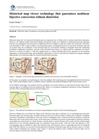
  • 1. Historical map viewer technology that guarantees nonlinear bijective conversion without distortion Kohei Otsuka a, * a Code for History, rekishikokudo@tilemap.jp Keywords: Historical maps, Coordinates conversion,Opensource GIS Abstract: Historical maps rich in historical information play an important role in fields such as tourism and history education. However, for ordinary people without knowledge of historical studies, it is difficult to understand inaccurate old maps that have not undergone surveying and to comprehend them in comparison with the current city townscape. Therefore, conventionally in GIS, a large number of corresponding points are prepared between an inaccurate historical map and an accurate map, the coordinates of the historical map are converted by forming a triangular mesh and conducting coordinate complement calculation, and the entire historical map image is re -represented by coordinate conversion. However, as shown in Figure 1, with this method there is a serious problem that causes distortion in the aesthetic appearance of the historical map, and remarkable impairment. It can be said that this problem has greatly damaged opportunities to use historical maps for tourism and historical education. Figure 1. Examples of historical map distorted by coordinate conversion by conventionalGIS method. In this paper, we introduce our technology to solve this problem. Our technology has been implemented in the histo rical map viewer named Maplat, which is available at https://github.com/code4nara/Maplat as MIT-licensed open source. In the Maplat technology, the method used for coordinate conversion between an inaccurate historical map and an accurate map is not different from conventional GIS, which is a coordinate complement calculation using a triangulate network of the corresponding point (as shown in Figure 2.). Figure 2. The method of coordinate conversion using triangulate network of the corresponding point. However, Maplat does not distort the image of the historical map when switching over or superimposing inaccurate historical maps and accurate maps. Instead, whenever the user scrolls the map to change the viewpoint, coordinate conversion calculation is performed in real time, and the overlapping state is corrected so that the position is perfectly fitted only at the center point of the screen. At the same time, coordinate conversion is performed at a plurality of points surrounding the center point at a fixed distance, and the pixel to actual distance ratio (scale) and the rotation angle (direction) on the currently displayed map are calculated using these points. Then the scale and direction of the corresponding map is modified to match the obtained scale and direction, and it is superimposed with the displayed map. With this method, we succeed in positioning and overlaying a historical map with an accurate map to a certain extent without damaging the aesthetic value. Figure 3 shows the behavior when multiple historical maps and an accurate map are successively switched in Maplat. Historical Map Accurate Map
  • 2. Figure 3. Behavior when switching maps successively in Maplat technology. A similar approach, roughly overlapping multiple maps by matching the center point, the scale, and the direction, is also adopted by another technology, implemented in a service called Stroly (https://stroly.com/en). This technology began commercial distribution in 2010. However, Stroly uses a newly developed calculation method of coordinate conversion, and because it abandons the calculation method of GIS backed by long-term achievement, there is inaccuracy in the coordinate conversion result. Especially when bidirectional coordinate conversion is repeated between multiple maps, there is a problem that the converted coordinates cannot return to the original place. In contrast, in Maplat, it is possible to guarantee bijective conversion, which always returns to its original location even when conversion is repeated, in coordinate conversions between inaccurate historical maps and accurate maps. Figure 4 shows the result of using Maplat technology and the Stroly technology to convert lattice point sequences on a 1784 Paris map once to longitude and latitude and then inversely convert it back to the coordinates on the historical map. The dark red line is the conversion result of Maplat, and the yellow line is that of Stroly. The conversion result of Maplat is correctly returned to the original lattice shape, and the average conversion error also falls below the rou nding error for the number of pixels, but in the Stroly technology the lattice structure is disturbed, and the average conversion error reaches 11 pixels. Figure 4. Comparison of bidirectional coordinate conversion accuracy in Maplat vs Stroly technology. In this way the Maplat technology, which does not distort the historical map and does not impair the aesthetic value while guaranteeing the bijective coordinate conversion as in the case of conventional GIS, has been used in fieldwork aimed at historical education (as shown in Figure 5.). As a result, a positive evaluation was obtained that there was a good educational effect through the characteristics of the Maplat technology. Figure 5. Fieldwork using Maplat technology.