SlideShare a Scribd company logo
1 of 1
g.infer: A GRASS GIS Module for rule-based data-driven
Classification and Workflow Control
Peter Löwe GISIX.com, Potsdam, Germany
Contact: loewe@gisix.com
Abstract
g.infer is a new add-on module for GRASS GIS (V6.4.x /V.7.0) to compose
flexible rule-driven GIS workflows based on GRASS modules. The module
enables rule-based analysis and workflow management using data-driven
inference processes based on the C Language Integrated Production System
(CLIPS). G.infer supports raster, volume and point vector GIS-layers. GRASS
GIS environment variables can also be queried and manipulated. Built-in rule-
base templates allow the quick set-up of expert systems and workflows in GIS
environments. An interactive mode enables direct interaction with the rule-
base environment on the fly.
Application scenarios range from rule-based classification tasks, event-driven
workflow-control to complex simulations for tasks such as Soil Erosion
Monitoring and Disaster Early Warning
Expert Systems for GIS Applications
Knowledge-based systems, also known as Expert Systems, facilitate the encoding of
human knowledge for automated reasoning or inference, i.e., the processing of data
to infer conclusions, which can be mapped out in a GIS. The overall process of
making human expertise available through an Expert System is called Knowledge
Engineering. A rule-based software toolkit (Production Rule System toolkit) for the
implementation of Expert System instances for specific knowledge-domains is the
core of g.infer: The C Language Integrated Production System (CLIPS) project
was started by NASA (Johnson Space Center) in 1985. It is currently hosted at
Sourceforge (clipsrules.sourceforge.net/). CLIPS is integrated in g.infer via the
PyCLIPS Python module (pyclips.sourceforge.net/).
Rule-based GIS workflows
In GIS, the development of such „map-making“ workflows is usually handled by
stepwise execution of the consecutive processing steps by a human operator, to
create and document the unfolding workflow, by interacting with the actual spatial
data. Once a mapping workflow has been laid out, the next step is automatization,
turning it into software. This can involve scripting, i.e. the definition of an execution-
chain of available GIS modules, or programming, which includes the development of
new GIS modules. Free and Open Source GIS like GRASS GIS allow rapid
development of both solutions as the overall codebase can be exploited. However, if
a mapping workflow can be formulated by the human GIS operator, but can not be
implemented as script or GIS module, there’s a problem.
Challenging GIS workflows:
•Classification tasks which may not appear demanding, but no robust way for building
a solution can be defined in acceptable time and effort.
•Simple workflows, where the processing rules keep changing depending on the
available input and other parameters.
•Problems which have not fully understood or are very complex to solve.
Benefits of rule-based programming:
•Rule-based modeling allows to focus on “What to Do” instead of “How to do It”.
•Rules allow to express solutions to complex problems and to verify them
consequently by logging and retracing the decision steps leading to a particular
solution.
•Separation of logic (“know-how”) and data allows to keep the know-how to be
stored in centralized rule-bases, providing a central point of access for further editing
and improvement.
•Human-readable rules serve as their own documentation and can be reviewed by
domain experts.
Figure 1: Interaction of the g.infer module with related GRASS GIS components and the CLIPS
Production Rule System. Human experts (shown as figurines) can interact with this work
environment independently on multiple levels.
Figure 2: Overview of the interactions between the GRASS GIS environment (green), the CLIPS-
based inference environment (blue) and external data sources (grey), highlighting (red) the
potential for workflow control to be excerted by the inference process.
Figure 3: Graphical User Interfaces of g.infer for the import of GIS data
(top), settings of the CLIPS inference engine (center) and output options
(bottom).

More Related Content

Viewers also liked

The Evolution of Disaster Early Warning Systems in the TRIDEC Project
The Evolution of Disaster Early Warning Systems in the TRIDEC ProjectThe Evolution of Disaster Early Warning Systems in the TRIDEC Project
The Evolution of Disaster Early Warning Systems in the TRIDEC Project
Peter Löwe
 
3D Printing: GIS Day 2013 Work in Progress Report
3D Printing: GIS Day 2013 Work in Progress Report3D Printing: GIS Day 2013 Work in Progress Report
3D Printing: GIS Day 2013 Work in Progress Report
Peter Löwe
 
FOSSGIS 2012: RapidEye Satellitenbildkarten und GRASS GIS: Neue Optionen der ...
FOSSGIS 2012: RapidEye Satellitenbildkarten und GRASS GIS: Neue Optionen der ...FOSSGIS 2012: RapidEye Satellitenbildkarten und GRASS GIS: Neue Optionen der ...
FOSSGIS 2012: RapidEye Satellitenbildkarten und GRASS GIS: Neue Optionen der ...
Peter Löwe
 
Coming of Age: The positive legacy of FOSS GIS
Coming of Age: The positive legacy of FOSS GISComing of Age: The positive legacy of FOSS GIS
Coming of Age: The positive legacy of FOSS GIS
Peter Löwe
 
Data Science: History repeated? – The heritage of the Free and Open Source GI...
Data Science: History repeated? – The heritage of the Free and Open Source GI...Data Science: History repeated? – The heritage of the Free and Open Source GI...
Data Science: History repeated? – The heritage of the Free and Open Source GI...
Peter Löwe
 
Acquisition of audiovisual Scientific Technical Information from OSGeo: A wor...
Acquisition of audiovisual Scientific Technical Information from OSGeo: A wor...Acquisition of audiovisual Scientific Technical Information from OSGeo: A wor...
Acquisition of audiovisual Scientific Technical Information from OSGeo: A wor...
Peter Löwe
 
First public screening of the high resolution version of the GRASS GIS video...
First public screening of the high resolution version of the  GRASS GIS video...First public screening of the high resolution version of the  GRASS GIS video...
First public screening of the high resolution version of the GRASS GIS video...
Peter Löwe
 
EGU 2012 ESSI: The FOSS GIS Workbench on the GFZ Load Sharing Facility compu...
EGU 2012 ESSI:  The FOSS GIS Workbench on the GFZ Load Sharing Facility compu...EGU 2012 ESSI:  The FOSS GIS Workbench on the GFZ Load Sharing Facility compu...
EGU 2012 ESSI: The FOSS GIS Workbench on the GFZ Load Sharing Facility compu...
Peter Löwe
 
Scientific 3D Printing with GRASS GIS (FOSSGIS 2014)
Scientific 3D Printing with GRASS GIS (FOSSGIS 2014)Scientific 3D Printing with GRASS GIS (FOSSGIS 2014)
Scientific 3D Printing with GRASS GIS (FOSSGIS 2014)
Peter Löwe
 
Tectonic Storytelling with Open Source and Digital Object Identifiers - a cas...
Tectonic Storytelling with Open Source and Digital Object Identifiers - a cas...Tectonic Storytelling with Open Source and Digital Object Identifiers - a cas...
Tectonic Storytelling with Open Source and Digital Object Identifiers - a cas...
Peter Löwe
 
FOSSGIS 2015: Das audiovisuelle Erbe der OSGeo-Projekte
FOSSGIS 2015: Das audiovisuelle Erbe der OSGeo-ProjekteFOSSGIS 2015: Das audiovisuelle Erbe der OSGeo-Projekte
FOSSGIS 2015: Das audiovisuelle Erbe der OSGeo-Projekte
Peter Löwe
 
Visualisierung Raum-Zeit Würfel
Visualisierung Raum-Zeit WürfelVisualisierung Raum-Zeit Würfel
Visualisierung Raum-Zeit Würfel
Peter Löwe
 

Viewers also liked (20)

The Evolution of Disaster Early Warning Systems in the TRIDEC Project
The Evolution of Disaster Early Warning Systems in the TRIDEC ProjectThe Evolution of Disaster Early Warning Systems in the TRIDEC Project
The Evolution of Disaster Early Warning Systems in the TRIDEC Project
 
3D Printing: GIS Day 2013 Work in Progress Report
3D Printing: GIS Day 2013 Work in Progress Report3D Printing: GIS Day 2013 Work in Progress Report
3D Printing: GIS Day 2013 Work in Progress Report
 
FOSSGIS 2012: RapidEye Satellitenbildkarten und GRASS GIS: Neue Optionen der ...
FOSSGIS 2012: RapidEye Satellitenbildkarten und GRASS GIS: Neue Optionen der ...FOSSGIS 2012: RapidEye Satellitenbildkarten und GRASS GIS: Neue Optionen der ...
FOSSGIS 2012: RapidEye Satellitenbildkarten und GRASS GIS: Neue Optionen der ...
 
Coming of Age: The positive legacy of FOSS GIS
Coming of Age: The positive legacy of FOSS GISComing of Age: The positive legacy of FOSS GIS
Coming of Age: The positive legacy of FOSS GIS
 
GRASS GIS lightening talk at FOSS4G 2006
GRASS GIS lightening talk at FOSS4G 2006GRASS GIS lightening talk at FOSS4G 2006
GRASS GIS lightening talk at FOSS4G 2006
 
Data Science: History repeated? – The heritage of the Free and Open Source GI...
Data Science: History repeated? – The heritage of the Free and Open Source GI...Data Science: History repeated? – The heritage of the Free and Open Source GI...
Data Science: History repeated? – The heritage of the Free and Open Source GI...
 
Acquisition of audiovisual Scientific Technical Information from OSGeo: A wor...
Acquisition of audiovisual Scientific Technical Information from OSGeo: A wor...Acquisition of audiovisual Scientific Technical Information from OSGeo: A wor...
Acquisition of audiovisual Scientific Technical Information from OSGeo: A wor...
 
Unlocking conference videos by DOI/MFID for software project communities
Unlocking conference videos by DOI/MFID for software project communitiesUnlocking conference videos by DOI/MFID for software project communities
Unlocking conference videos by DOI/MFID for software project communities
 
Mapping the Tohoku 2011 Tsunami event with a remote sensing satellite constel...
Mapping the Tohoku 2011 Tsunami event with a remote sensing satellite constel...Mapping the Tohoku 2011 Tsunami event with a remote sensing satellite constel...
Mapping the Tohoku 2011 Tsunami event with a remote sensing satellite constel...
 
EGU 2013: Splinter Meeting: Free and Open Source Software (FOSS) in the Geosc...
EGU 2013: Splinter Meeting: Free and Open Source Software (FOSS) in the Geosc...EGU 2013: Splinter Meeting: Free and Open Source Software (FOSS) in the Geosc...
EGU 2013: Splinter Meeting: Free and Open Source Software (FOSS) in the Geosc...
 
First public screening of the high resolution version of the GRASS GIS video...
First public screening of the high resolution version of the  GRASS GIS video...First public screening of the high resolution version of the  GRASS GIS video...
First public screening of the high resolution version of the GRASS GIS video...
 
EGU 2012 ESSI: The FOSS GIS Workbench on the GFZ Load Sharing Facility compu...
EGU 2012 ESSI:  The FOSS GIS Workbench on the GFZ Load Sharing Facility compu...EGU 2012 ESSI:  The FOSS GIS Workbench on the GFZ Load Sharing Facility compu...
EGU 2012 ESSI: The FOSS GIS Workbench on the GFZ Load Sharing Facility compu...
 
Advanced KML with GRASS GIS
Advanced KML with GRASS GIS Advanced KML with GRASS GIS
Advanced KML with GRASS GIS
 
The Evolution of Disaster Early Warning Systems in the TRIDEC Project
The Evolution of Disaster Early Warning Systems in the TRIDEC Project The Evolution of Disaster Early Warning Systems in the TRIDEC Project
The Evolution of Disaster Early Warning Systems in the TRIDEC Project
 
Scientific 3D Printing with GRASS GIS (FOSSGIS 2014)
Scientific 3D Printing with GRASS GIS (FOSSGIS 2014)Scientific 3D Printing with GRASS GIS (FOSSGIS 2014)
Scientific 3D Printing with GRASS GIS (FOSSGIS 2014)
 
Tectonic Storytelling with Open Source and Digital Object Identifiers - a cas...
Tectonic Storytelling with Open Source and Digital Object Identifiers - a cas...Tectonic Storytelling with Open Source and Digital Object Identifiers - a cas...
Tectonic Storytelling with Open Source and Digital Object Identifiers - a cas...
 
GRASS GIS, Star Trek and old Video Tape – a reference case on audiovisual pre...
GRASS GIS, Star Trek and old Video Tape – a reference case on audiovisual pre...GRASS GIS, Star Trek and old Video Tape – a reference case on audiovisual pre...
GRASS GIS, Star Trek and old Video Tape – a reference case on audiovisual pre...
 
FOSSGIS 2015: Das audiovisuelle Erbe der OSGeo-Projekte
FOSSGIS 2015: Das audiovisuelle Erbe der OSGeo-ProjekteFOSSGIS 2015: Das audiovisuelle Erbe der OSGeo-Projekte
FOSSGIS 2015: Das audiovisuelle Erbe der OSGeo-Projekte
 
Visualisierung Raum-Zeit Würfel
Visualisierung Raum-Zeit WürfelVisualisierung Raum-Zeit Würfel
Visualisierung Raum-Zeit Würfel
 
TIB's action for research data managament as a national library's strategy in...
TIB's action for research data managament as a national library's strategy in...TIB's action for research data managament as a national library's strategy in...
TIB's action for research data managament as a national library's strategy in...
 

Similar to EGU General Assembly 2013: The new g.infer add-on for GRASS GIS

Towards and adaptable spatial processing architecture
Towards and adaptable spatial processing architectureTowards and adaptable spatial processing architecture
Towards and adaptable spatial processing architecture
Armando Guevara
 
Spatial Data Integrator - Software Presentation and Use Cases
Spatial Data Integrator - Software Presentation and Use CasesSpatial Data Integrator - Software Presentation and Use Cases
Spatial Data Integrator - Software Presentation and Use Cases
mathieuraj
 
On the-design-of-geographic-information-system-procedures
On the-design-of-geographic-information-system-proceduresOn the-design-of-geographic-information-system-procedures
On the-design-of-geographic-information-system-procedures
Armando Guevara
 
Final Report_798 Project_Nithin_Sharmila
Final Report_798 Project_Nithin_SharmilaFinal Report_798 Project_Nithin_Sharmila
Final Report_798 Project_Nithin_Sharmila
Nithin Kakkireni
 

Similar to EGU General Assembly 2013: The new g.infer add-on for GRASS GIS (20)

Towards and adaptable spatial processing architecture
Towards and adaptable spatial processing architectureTowards and adaptable spatial processing architecture
Towards and adaptable spatial processing architecture
 
Mrp Intrim
Mrp IntrimMrp Intrim
Mrp Intrim
 
BIG GRAPH: TOOLS, TECHNIQUES, ISSUES, CHALLENGES AND FUTURE DIRECTIONS
BIG GRAPH: TOOLS, TECHNIQUES, ISSUES, CHALLENGES AND FUTURE DIRECTIONSBIG GRAPH: TOOLS, TECHNIQUES, ISSUES, CHALLENGES AND FUTURE DIRECTIONS
BIG GRAPH: TOOLS, TECHNIQUES, ISSUES, CHALLENGES AND FUTURE DIRECTIONS
 
Big Graph : Tools, Techniques, Issues, Challenges and Future Directions
Big Graph : Tools, Techniques, Issues, Challenges and Future Directions Big Graph : Tools, Techniques, Issues, Challenges and Future Directions
Big Graph : Tools, Techniques, Issues, Challenges and Future Directions
 
MAP-REDUCE IMPLEMENTATIONS: SURVEY AND PERFORMANCE COMPARISON
MAP-REDUCE IMPLEMENTATIONS: SURVEY AND PERFORMANCE COMPARISONMAP-REDUCE IMPLEMENTATIONS: SURVEY AND PERFORMANCE COMPARISON
MAP-REDUCE IMPLEMENTATIONS: SURVEY AND PERFORMANCE COMPARISON
 
What is GIS (PDF).pdf
What is GIS (PDF).pdfWhat is GIS (PDF).pdf
What is GIS (PDF).pdf
 
Towards an adaptable spatial processing architecture
Towards an adaptable spatial processing architectureTowards an adaptable spatial processing architecture
Towards an adaptable spatial processing architecture
 
In-Memory Compute Grids… Explained
In-Memory Compute Grids… ExplainedIn-Memory Compute Grids… Explained
In-Memory Compute Grids… Explained
 
Introduction To Geographical Information System (GIS)
Introduction To Geographical Information System (GIS) Introduction To Geographical Information System (GIS)
Introduction To Geographical Information System (GIS)
 
ARCHITECTURAL FRAMEWORK FOR DEVELOPING COMPONENT BASED GIS SYSTEM
ARCHITECTURAL FRAMEWORK FOR DEVELOPING COMPONENT BASED GIS SYSTEMARCHITECTURAL FRAMEWORK FOR DEVELOPING COMPONENT BASED GIS SYSTEM
ARCHITECTURAL FRAMEWORK FOR DEVELOPING COMPONENT BASED GIS SYSTEM
 
ARCHITECTURAL FRAMEWORK FOR DEVELOPING COMPONENT BASED GIS SYSTEM
ARCHITECTURAL FRAMEWORK FOR DEVELOPING COMPONENT BASED GIS SYSTEMARCHITECTURAL FRAMEWORK FOR DEVELOPING COMPONENT BASED GIS SYSTEM
ARCHITECTURAL FRAMEWORK FOR DEVELOPING COMPONENT BASED GIS SYSTEM
 
ARCHITECTURAL FRAMEWORK FOR DEVELOPING COMPONENT BASED GIS SYSTEM
ARCHITECTURAL FRAMEWORK FOR DEVELOPING COMPONENT BASED GIS SYSTEMARCHITECTURAL FRAMEWORK FOR DEVELOPING COMPONENT BASED GIS SYSTEM
ARCHITECTURAL FRAMEWORK FOR DEVELOPING COMPONENT BASED GIS SYSTEM
 
H017235155
H017235155H017235155
H017235155
 
Internet-Based Geographical Information Systems for the Real Estate Marketing
Internet-Based Geographical Information Systems for the Real Estate MarketingInternet-Based Geographical Information Systems for the Real Estate Marketing
Internet-Based Geographical Information Systems for the Real Estate Marketing
 
Spatial Data Integrator - Software Presentation and Use Cases
Spatial Data Integrator - Software Presentation and Use CasesSpatial Data Integrator - Software Presentation and Use Cases
Spatial Data Integrator - Software Presentation and Use Cases
 
On the-design-of-geographic-information-system-procedures
On the-design-of-geographic-information-system-proceduresOn the-design-of-geographic-information-system-procedures
On the-design-of-geographic-information-system-procedures
 
Grid Presentation
Grid PresentationGrid Presentation
Grid Presentation
 
H017144148
H017144148H017144148
H017144148
 
Comparative Analysis, Security Aspects & Optimization of Workload in Gfs Base...
Comparative Analysis, Security Aspects & Optimization of Workload in Gfs Base...Comparative Analysis, Security Aspects & Optimization of Workload in Gfs Base...
Comparative Analysis, Security Aspects & Optimization of Workload in Gfs Base...
 
Final Report_798 Project_Nithin_Sharmila
Final Report_798 Project_Nithin_SharmilaFinal Report_798 Project_Nithin_Sharmila
Final Report_798 Project_Nithin_Sharmila
 

More from Peter Löwe

INTEGRATION OPTIONS FOR PERSISTENT IDENTIFIERS IN OSGEO PROJECT REPOSITORIES:...
INTEGRATION OPTIONS FOR PERSISTENT IDENTIFIERS IN OSGEO PROJECT REPOSITORIES:...INTEGRATION OPTIONS FOR PERSISTENT IDENTIFIERS IN OSGEO PROJECT REPOSITORIES:...
INTEGRATION OPTIONS FOR PERSISTENT IDENTIFIERS IN OSGEO PROJECT REPOSITORIES:...
Peter Löwe
 
The TIB|AV Portal : OSGeo conference videos as a resource for scientific res...
The TIB|AV Portal : OSGeo conference videos as a resource for scientific res...The TIB|AV Portal : OSGeo conference videos as a resource for scientific res...
The TIB|AV Portal : OSGeo conference videos as a resource for scientific res...
Peter Löwe
 
3D-printing with GRASS GIS – a work in progress in report FOSS4G 2014
3D-printing with GRASS GIS – a work in progress in report FOSS4G 20143D-printing with GRASS GIS – a work in progress in report FOSS4G 2014
3D-printing with GRASS GIS – a work in progress in report FOSS4G 2014
Peter Löwe
 
Potentiale und Chancen von Free Open Source Software (FOSS) GIS für die Forsc...
Potentiale und Chancen von Free Open Source Software (FOSS) GIS für die Forsc...Potentiale und Chancen von Free Open Source Software (FOSS) GIS für die Forsc...
Potentiale und Chancen von Free Open Source Software (FOSS) GIS für die Forsc...
Peter Löwe
 
GIS: Eine Übersicht für Lehrkräfte
GIS: Eine Übersicht für LehrkräfteGIS: Eine Übersicht für Lehrkräfte
GIS: Eine Übersicht für Lehrkräfte
Peter Löwe
 
Mapping the Tohoku 2011 Tsunami event with a remote sensing satellite constel...
Mapping the Tohoku 2011 Tsunami event with a remote sensing satellite constel...Mapping the Tohoku 2011 Tsunami event with a remote sensing satellite constel...
Mapping the Tohoku 2011 Tsunami event with a remote sensing satellite constel...
Peter Löwe
 
Geopark Bergstraße-Odenwald
Geopark Bergstraße-OdenwaldGeopark Bergstraße-Odenwald
Geopark Bergstraße-Odenwald
Peter Löwe
 

More from Peter Löwe (17)

EGU GA 2018 OSGeo Townhall
EGU GA 2018 OSGeo TownhallEGU GA 2018 OSGeo Townhall
EGU GA 2018 OSGeo Townhall
 
EGU GA 2017 OSGeo Townhall
EGU GA 2017 OSGeo TownhallEGU GA 2017 OSGeo Townhall
EGU GA 2017 OSGeo Townhall
 
EGU GA 2014 OSGeo Townhall
EGU GA 2014 OSGeo TownhallEGU GA 2014 OSGeo Townhall
EGU GA 2014 OSGeo Townhall
 
EGU 2013 Splinter Meeting: FOSS in the Geosciences
EGU 2013 Splinter Meeting: FOSS in the Geosciences EGU 2013 Splinter Meeting: FOSS in the Geosciences
EGU 2013 Splinter Meeting: FOSS in the Geosciences
 
2012 egu foss_splinter_session
2012 egu foss_splinter_session2012 egu foss_splinter_session
2012 egu foss_splinter_session
 
INTEGRATION OPTIONS FOR PERSISTENT IDENTIFIERS IN OSGEO PROJECT REPOSITORIES:...
INTEGRATION OPTIONS FOR PERSISTENT IDENTIFIERS IN OSGEO PROJECT REPOSITORIES:...INTEGRATION OPTIONS FOR PERSISTENT IDENTIFIERS IN OSGEO PROJECT REPOSITORIES:...
INTEGRATION OPTIONS FOR PERSISTENT IDENTIFIERS IN OSGEO PROJECT REPOSITORIES:...
 
Research Data Management for Econometrics
Research Data Management for EconometricsResearch Data Management for Econometrics
Research Data Management for Econometrics
 
Libraries in the Big Data Era: Strategies and Challenges in Archiving and Sha...
Libraries in the Big Data Era: Strategies and Challenges in Archiving and Sha...Libraries in the Big Data Era: Strategies and Challenges in Archiving and Sha...
Libraries in the Big Data Era: Strategies and Challenges in Archiving and Sha...
 
The TIB|AV Portal : OSGeo conference videos as a resource for scientific res...
The TIB|AV Portal : OSGeo conference videos as a resource for scientific res...The TIB|AV Portal : OSGeo conference videos as a resource for scientific res...
The TIB|AV Portal : OSGeo conference videos as a resource for scientific res...
 
GIS Day 2015: Geoinformatics, Open Source and Videos - a library perspective
GIS Day 2015: Geoinformatics, Open Source and Videos - a library perspectiveGIS Day 2015: Geoinformatics, Open Source and Videos - a library perspective
GIS Day 2015: Geoinformatics, Open Source and Videos - a library perspective
 
GIS DAY 2015: Guerilla globes
GIS DAY 2015: Guerilla globes GIS DAY 2015: Guerilla globes
GIS DAY 2015: Guerilla globes
 
3D-printing with GRASS GIS – a work in progress in report FOSS4G 2014
3D-printing with GRASS GIS – a work in progress in report FOSS4G 20143D-printing with GRASS GIS – a work in progress in report FOSS4G 2014
3D-printing with GRASS GIS – a work in progress in report FOSS4G 2014
 
Potentiale und Chancen von Free Open Source Software (FOSS) GIS für die Forsc...
Potentiale und Chancen von Free Open Source Software (FOSS) GIS für die Forsc...Potentiale und Chancen von Free Open Source Software (FOSS) GIS für die Forsc...
Potentiale und Chancen von Free Open Source Software (FOSS) GIS für die Forsc...
 
GIS: Eine Übersicht für Lehrkräfte
GIS: Eine Übersicht für LehrkräfteGIS: Eine Übersicht für Lehrkräfte
GIS: Eine Übersicht für Lehrkräfte
 
Mapping the Tohoku 2011 Tsunami event with a remote sensing satellite constel...
Mapping the Tohoku 2011 Tsunami event with a remote sensing satellite constel...Mapping the Tohoku 2011 Tsunami event with a remote sensing satellite constel...
Mapping the Tohoku 2011 Tsunami event with a remote sensing satellite constel...
 
LINUX Tag 2008: 4D Data Visualisation and Quality Control
LINUX Tag 2008: 4D Data Visualisation and Quality ControlLINUX Tag 2008: 4D Data Visualisation and Quality Control
LINUX Tag 2008: 4D Data Visualisation and Quality Control
 
Geopark Bergstraße-Odenwald
Geopark Bergstraße-OdenwaldGeopark Bergstraße-Odenwald
Geopark Bergstraße-Odenwald
 

Recently uploaded

IAC 2024 - IA Fast Track to Search Focused AI Solutions
IAC 2024 - IA Fast Track to Search Focused AI SolutionsIAC 2024 - IA Fast Track to Search Focused AI Solutions
IAC 2024 - IA Fast Track to Search Focused AI Solutions
Enterprise Knowledge
 
Histor y of HAM Radio presentation slide
Histor y of HAM Radio presentation slideHistor y of HAM Radio presentation slide
Histor y of HAM Radio presentation slide
vu2urc
 

Recently uploaded (20)

08448380779 Call Girls In Civil Lines Women Seeking Men
08448380779 Call Girls In Civil Lines Women Seeking Men08448380779 Call Girls In Civil Lines Women Seeking Men
08448380779 Call Girls In Civil Lines Women Seeking Men
 
From Event to Action: Accelerate Your Decision Making with Real-Time Automation
From Event to Action: Accelerate Your Decision Making with Real-Time AutomationFrom Event to Action: Accelerate Your Decision Making with Real-Time Automation
From Event to Action: Accelerate Your Decision Making with Real-Time Automation
 
Axa Assurance Maroc - Insurer Innovation Award 2024
Axa Assurance Maroc - Insurer Innovation Award 2024Axa Assurance Maroc - Insurer Innovation Award 2024
Axa Assurance Maroc - Insurer Innovation Award 2024
 
IAC 2024 - IA Fast Track to Search Focused AI Solutions
IAC 2024 - IA Fast Track to Search Focused AI SolutionsIAC 2024 - IA Fast Track to Search Focused AI Solutions
IAC 2024 - IA Fast Track to Search Focused AI Solutions
 
The Role of Taxonomy and Ontology in Semantic Layers - Heather Hedden.pdf
The Role of Taxonomy and Ontology in Semantic Layers - Heather Hedden.pdfThe Role of Taxonomy and Ontology in Semantic Layers - Heather Hedden.pdf
The Role of Taxonomy and Ontology in Semantic Layers - Heather Hedden.pdf
 
Apidays Singapore 2024 - Building Digital Trust in a Digital Economy by Veron...
Apidays Singapore 2024 - Building Digital Trust in a Digital Economy by Veron...Apidays Singapore 2024 - Building Digital Trust in a Digital Economy by Veron...
Apidays Singapore 2024 - Building Digital Trust in a Digital Economy by Veron...
 
Factors to Consider When Choosing Accounts Payable Services Providers.pptx
Factors to Consider When Choosing Accounts Payable Services Providers.pptxFactors to Consider When Choosing Accounts Payable Services Providers.pptx
Factors to Consider When Choosing Accounts Payable Services Providers.pptx
 
Data Cloud, More than a CDP by Matt Robison
Data Cloud, More than a CDP by Matt RobisonData Cloud, More than a CDP by Matt Robison
Data Cloud, More than a CDP by Matt Robison
 
Advantages of Hiring UIUX Design Service Providers for Your Business
Advantages of Hiring UIUX Design Service Providers for Your BusinessAdvantages of Hiring UIUX Design Service Providers for Your Business
Advantages of Hiring UIUX Design Service Providers for Your Business
 
A Domino Admins Adventures (Engage 2024)
A Domino Admins Adventures (Engage 2024)A Domino Admins Adventures (Engage 2024)
A Domino Admins Adventures (Engage 2024)
 
Mastering MySQL Database Architecture: Deep Dive into MySQL Shell and MySQL R...
Mastering MySQL Database Architecture: Deep Dive into MySQL Shell and MySQL R...Mastering MySQL Database Architecture: Deep Dive into MySQL Shell and MySQL R...
Mastering MySQL Database Architecture: Deep Dive into MySQL Shell and MySQL R...
 
Histor y of HAM Radio presentation slide
Histor y of HAM Radio presentation slideHistor y of HAM Radio presentation slide
Histor y of HAM Radio presentation slide
 
TrustArc Webinar - Stay Ahead of US State Data Privacy Law Developments
TrustArc Webinar - Stay Ahead of US State Data Privacy Law DevelopmentsTrustArc Webinar - Stay Ahead of US State Data Privacy Law Developments
TrustArc Webinar - Stay Ahead of US State Data Privacy Law Developments
 
The 7 Things I Know About Cyber Security After 25 Years | April 2024
The 7 Things I Know About Cyber Security After 25 Years | April 2024The 7 Things I Know About Cyber Security After 25 Years | April 2024
The 7 Things I Know About Cyber Security After 25 Years | April 2024
 
04-2024-HHUG-Sales-and-Marketing-Alignment.pptx
04-2024-HHUG-Sales-and-Marketing-Alignment.pptx04-2024-HHUG-Sales-and-Marketing-Alignment.pptx
04-2024-HHUG-Sales-and-Marketing-Alignment.pptx
 
Powerful Google developer tools for immediate impact! (2023-24 C)
Powerful Google developer tools for immediate impact! (2023-24 C)Powerful Google developer tools for immediate impact! (2023-24 C)
Powerful Google developer tools for immediate impact! (2023-24 C)
 
2024: Domino Containers - The Next Step. News from the Domino Container commu...
2024: Domino Containers - The Next Step. News from the Domino Container commu...2024: Domino Containers - The Next Step. News from the Domino Container commu...
2024: Domino Containers - The Next Step. News from the Domino Container commu...
 
🐬 The future of MySQL is Postgres 🐘
🐬  The future of MySQL is Postgres   🐘🐬  The future of MySQL is Postgres   🐘
🐬 The future of MySQL is Postgres 🐘
 
Presentation on how to chat with PDF using ChatGPT code interpreter
Presentation on how to chat with PDF using ChatGPT code interpreterPresentation on how to chat with PDF using ChatGPT code interpreter
Presentation on how to chat with PDF using ChatGPT code interpreter
 
Breaking the Kubernetes Kill Chain: Host Path Mount
Breaking the Kubernetes Kill Chain: Host Path MountBreaking the Kubernetes Kill Chain: Host Path Mount
Breaking the Kubernetes Kill Chain: Host Path Mount
 

EGU General Assembly 2013: The new g.infer add-on for GRASS GIS

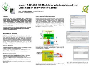
  • 1. g.infer: A GRASS GIS Module for rule-based data-driven Classification and Workflow Control Peter Löwe GISIX.com, Potsdam, Germany Contact: loewe@gisix.com Abstract g.infer is a new add-on module for GRASS GIS (V6.4.x /V.7.0) to compose flexible rule-driven GIS workflows based on GRASS modules. The module enables rule-based analysis and workflow management using data-driven inference processes based on the C Language Integrated Production System (CLIPS). G.infer supports raster, volume and point vector GIS-layers. GRASS GIS environment variables can also be queried and manipulated. Built-in rule- base templates allow the quick set-up of expert systems and workflows in GIS environments. An interactive mode enables direct interaction with the rule- base environment on the fly. Application scenarios range from rule-based classification tasks, event-driven workflow-control to complex simulations for tasks such as Soil Erosion Monitoring and Disaster Early Warning Expert Systems for GIS Applications Knowledge-based systems, also known as Expert Systems, facilitate the encoding of human knowledge for automated reasoning or inference, i.e., the processing of data to infer conclusions, which can be mapped out in a GIS. The overall process of making human expertise available through an Expert System is called Knowledge Engineering. A rule-based software toolkit (Production Rule System toolkit) for the implementation of Expert System instances for specific knowledge-domains is the core of g.infer: The C Language Integrated Production System (CLIPS) project was started by NASA (Johnson Space Center) in 1985. It is currently hosted at Sourceforge (clipsrules.sourceforge.net/). CLIPS is integrated in g.infer via the PyCLIPS Python module (pyclips.sourceforge.net/). Rule-based GIS workflows In GIS, the development of such „map-making“ workflows is usually handled by stepwise execution of the consecutive processing steps by a human operator, to create and document the unfolding workflow, by interacting with the actual spatial data. Once a mapping workflow has been laid out, the next step is automatization, turning it into software. This can involve scripting, i.e. the definition of an execution- chain of available GIS modules, or programming, which includes the development of new GIS modules. Free and Open Source GIS like GRASS GIS allow rapid development of both solutions as the overall codebase can be exploited. However, if a mapping workflow can be formulated by the human GIS operator, but can not be implemented as script or GIS module, there’s a problem. Challenging GIS workflows: •Classification tasks which may not appear demanding, but no robust way for building a solution can be defined in acceptable time and effort. •Simple workflows, where the processing rules keep changing depending on the available input and other parameters. •Problems which have not fully understood or are very complex to solve. Benefits of rule-based programming: •Rule-based modeling allows to focus on “What to Do” instead of “How to do It”. •Rules allow to express solutions to complex problems and to verify them consequently by logging and retracing the decision steps leading to a particular solution. •Separation of logic (“know-how”) and data allows to keep the know-how to be stored in centralized rule-bases, providing a central point of access for further editing and improvement. •Human-readable rules serve as their own documentation and can be reviewed by domain experts. Figure 1: Interaction of the g.infer module with related GRASS GIS components and the CLIPS Production Rule System. Human experts (shown as figurines) can interact with this work environment independently on multiple levels. Figure 2: Overview of the interactions between the GRASS GIS environment (green), the CLIPS- based inference environment (blue) and external data sources (grey), highlighting (red) the potential for workflow control to be excerted by the inference process. Figure 3: Graphical User Interfaces of g.infer for the import of GIS data (top), settings of the CLIPS inference engine (center) and output options (bottom).