MIMAROPA REGION: AN OVERVIEW

MIMAROPA is an administrative region in the Philippines, designated as Region IV-B. It is one of two regions in the country having no land border with another region, the other being Eastern Visayas. The name is an acronym combination of its constituent provinces, which are: Mindoro (divided into Occidental Mindoro and Oriental Mindoro), Marinduque, Romblon and Palawan. The region is also formally known as the Southern Tagalog Islands. Calapan City is the regional center. However, most regional government offices such as the Department of Public Works and Highways are in the city of Quezon in Metro Manila. The region was part of the now-defunct Southern Tagalog region until May 17, 2002.[4] On May 23, 2005, Palawan and the highly urbanized city of Puerto Princesa were moved to the region of Western Visayas by Executive Order No. 429. However, on August 19, 2005, then-President Arroyo issued Administrative Order No. 129 to hold the earlier EO 429 in abeyance pending a review.

Recommended
More Related Content
What's hot
What's hot (20)
Viewers also liked
Viewers also liked (20)
Similar to MIMAROPA REGION: AN OVERVIEW
Similar to MIMAROPA REGION: AN OVERVIEW (20)
More from Julienne Mae Valdez
Recently uploaded
Recently uploaded (20)
MIMAROPA REGION: AN OVERVIEW
- 2. AnOverview…
- 3. President Gloria Macapagal-Arroyo issued Executive Order 103 (EO103) on May 17, 2002 which subdivided the Southern Tagalog provinces which were included in Region IV into two regions — Regions IV-A and IV-B — to promote efficiency in the government, accelerate social and economic development and improve public services.
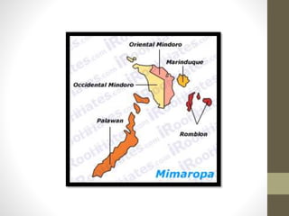
- 4. Region IV-B is known as MIMAROPA, standing for the island provinces belonging to the region — MIndoro (Oriental and Occidental), MArinduque, ROmblon and PAlawan. EO103 also transferred the province of Aurora to Region III in Central Luzon.
- 5. • Executive Order 429 moved Palawan to Region VI on May 23, 2005. • After this, Region IV-B began to be called MIMARO instead of MIMAROPA. However, Palaweños criticized the move, citing a lack of consultation, with most residents in Puerto Princesa City and nearly all municipalities preferring to stay with Region IV-B. • Consequently, Administrative Order No. 129 was issued on August 19, 2005 to address this backlash. This order directed the abeyance of Executive Order 429 pending the approval of an implementation plan for the orderly transfer of Palawan from MIMAROPA to Region VI.
- 6. TheirLanguages • Tagalog is widely spoken in the region. In Marinduque, Tagalog is spoken with a unique blend of Bicolano and Visayan languages. • In the interior of Mindoro, various languages are spoken by Mangyans, and they include Irena, Alangan, Tawbuid, Hanunoo, Tadyawan, Buhid, and Ratagnon. • Romblon, being near the Visayas, has three main languages that belong to Visayan language family namely, Romblomanon, Asi, and Onhan. • Palawan has its own set of native languages such as Cuyonon, Calamian Tagbanwa and Palawano that are spoken by significant numbers of people.
- 7. TheFiveProvinces… • Marinduque; Capital – Boac • Occidental Mindoro; Capital – Mamburao • Oriental Mindoro; Capital – Calapan City • Romblon; Capital – Puerto Prinsesa City • Palawan; Capital – Romblon
- 9. Mindoro • the seventh-largestisland in the Philippines •located offthe coast of Luzon, and northeast of Palawan •forms the northeastern extremum of the Sulu Sea
- 10. Brief History • has been called Mai or Mait by Chinese traders • as Mina de Oro (meaning "gold mine") by the Spaniards • The island was once a single province from 1920 to 1950 when it was divided into its two present-day provinces, Occidental Mindoro and Oriental Mindoro.
- 11. OccidentalMindoro Its capital is Mamburao and occupies the western half of the island of Mindoro, on the west by Apo East Pass, and on the south by the Mindoro Strait; Oriental Mindoro is at the eastern half. The South China Sea is to the west of the province and Palawan is located to the southwest, across Mindoro Strait. Batangas is to the north, separated by the Verde Island Passage.
- 12. Climate: • Occidental Mindoro has two distinct weather types: rainy season and dry season • The months of August and September are the wettest period, with storms directly passing through the area. • March and April are the driest period, with cloudless skies and parched earth characterizing the general area. • Temperature range is from 26 °C (79 °F) in the windy uplands to 32 °C (90 °F) in the lowlands.
- 13. Languages: • Tagalog • Kamangyan • English
- 14. Municipalities Municipalit y No. of Barangays Area (km²) Population (2010) Pop. density (per km²) Income Class (2008) Abra de Ilog 9 533.70 29,225 54.8 2nd Class Calintaan 7 382.50 28,148 73.6 3rd Class Looc 9 132.30 9,758 73.8 5th Class Lubang 16 113.10 23,068 204 4th Class Magsaysay 12 296.70 31,969 107.7 3rd Class Mamburao 15 283.51 39,237 138.4 2nd Class Paluan 12 564.50 15,223 27 3rd Class Rizal 11 242.50 34,458 142.1 3rd Class Sablayan 27 2,188.80 76,153 34.8 1st Class San Jose 38 446.70 131,188 293.7 1st Class Santa Cruz 11 681.40 34,544 50.7 1st Class
- 15. Wheretogo?
- 16. Apo Reef National Park Found in Apo Island, Sablayan, the park dubbed as the diving mecca of the Philippines, is a 34 kilometer reef that has a narrow channel dividing the reef into two lagoon systems. Beneath the clear water of these lagoons, divers can explore the fine white sand bottom with its colorful array of approximately 400 to 500 coral species. Almost 500 marine species, including a variety of sharks, stingrays and manta rays, can also be spotted around the area. Bird watchers can visit the fascinating bird populated islands of Binangaan and Cajos del Bajo, which is also part of the Apo Reef Marine Park.
- 18. Calawagan Mountain Resort The resort’s main attraction is the Calawagan River, which has won the Cleanest Inland Body of Water award several times. It also features natural and man-made pools, a hanging bridge, tree houses ad a natural rain forest.
- 20. White Island True to its name, this island has a mile long beach with divinely white and powdery smooth sand that makes it an ideal site for lounging under the sun. Aside from vacationers who go for swimming, fishing and scuba diving, the island is also a favorite nestling ground of turtles. Turtle eggs are often found buried in the sand, and visitors are enjoined to leave these undisturbed.
- 22. Presing Park The main attraction is the watchtower, which was constructed in 1861 and features a set of bells that were rung to warn the people of impending raids. The cannon that was used to defend the town still stands at the promontry.
- 24. Tayamaan Beach This one hectare-beach is lined with coconut tress and is a favorite swimming spot of the local residents.
- 26. Pandan Island The home of pandan island resort,which features a beautiful stip of whitish-sand beach.the place is also very ideal for picnics.
- 28. Ilin Island The main atrraction of the island is the mina de oro beach which boats of a fine white-sand beach.fifteen minutes from the beach by boat is a cave,the entrance to which you have to swim through if the tide high.
- 30. Howtotravel?
- 31. • Occidental Mindoro, 15 kilometers from the southwest coast of Luzon, is accessible by sea and air. Flights from Manila to San Jose are available from Sunday to Friday and travel time is around one hour. There are also chartered and commuter flights from Manila to Lubang Island that take about 45 minutes. • Travelers can likewise take a ferry from Batangas port to Abra de Ilog. Travel time takes about two and a half hours. From Abra de Ilog, there are air-conditioned vans plying the route to Sablayan and San Jose.
- 32. OrientalMindoro touted as the country's emerging eco-tourism destination
- 33. Brief History • World War II wrought heavy damages, death and pain to the people of Mindoro. • After the war, reconstruction and rehabilitation of infrastructure and economy took place which ended with the division of the island into two provinces of Oriental Mindoro and Occidental Mindoro on June 13, 1950, by virtue of the Republic Act No. 505. • the island continued to become one of the preferred areas of new settlers coming from the overpopulated provinces in the Philippines in search of the new land • Since then new settlers have incessantly migrated to Mindoro until today.
- 34. Municipalities • Baco • Bansud • Bongabong • Bulalacao • Gloria • Mansalay • Naujan • Pinamalayan • Pola • Puerto Galera • Roxas • San Teodoro • Socorro • Victoria
- 35. Wheretogo?
- 36. Aganahaw Island The island has a wide expanse of beach with whitish sand . suitable for swimming and picnicking .
- 38. Buyayao Island It is a rocky island, except for the area facing Buyayao Peninsula. Big snakes called "sobre kama" are found in the mountains. The water around the island is suited for deep-sea fishing. It is located off the coast of Mansalay, and can be reached in 30 minutes by motorized banca from Mansalay market.
- 39. Puerto Galera Puerto galera is a popular destination among tourist, aside from the beautiful beaches ,the town also offers a number of tourist facilities . the waters are ideal for scuba diving.
- 41. Bulalacao Beach A local favorite,this beach is frequented for by excurssionist.
- 43. Naujan Lake National Park This 79-square kilolometer,20-feet-deep is he largest in the province and the dwelling place of mindoro crocodile,the banak and the simbal,it is now a wildlife sangtuaryhunting and fishing are supervised by the natoinal park people.
- 45. Mount Halcon The fourth highest point in the country rising 2,586 meters above sea level, this mountain is a favorite among mountaineers , trekkers, and other nature lovers. Wild tamaraws still roam its forest.
- 48. END of Mindoro Province
- 49. MARINDUQUE
- 50. Geographic Profile • Composed of four major and eight minor islets. • Characterized by undulating hills, • Mountainous valleys, • Declivitous seaside cliffs, and patches of flatland.
- 51. Howtogetthere?
- 52. • From manila, take a Tritran bus to Dalahican, • From Dalahican take a ferry boat to Sta. Cruz and Balanacan; travel time is approximately two to three hours . • By plane - travel time is about 45 minutes.
- 53. WheretoGo?
- 54. Bathala Caves These mystical caves are said to be the respiratory of psychic emanating from various points the universe. They are believe to from a complex of seven caves; but currently only four have been complex.
- 56. Paadjao falls This series gently cascading falls end in a 10- foot-deep pool of crystal clear water. It is an ideal place for picnicking and campi.ng
- 58. Mount Malindig Rising 3,167 feet above the sea, Mt. Malindig dominates the south of Marinduque. Half of it is still covered with dense forest, while the other half has been deforested by slash-and-burn farmers.
- 61. ROMBLON
- 62. Area and location • The province of Romblon is composed of a cluster of 20 islands lying in the Sibuyan sea. • It has a total land area of 135,690 hectares.
- 63. GEOGRAPHIC PROFILE • Romblon has a mountainous and rugged terrain. • In highest peak is 2,057 meters above sea level. • The islands themselves are believe to have been formed by volcanic activity.
- 64. Howtogetthere?
- 65. • Can be reached by ferry boats originating from Batangas city port. • Sometimes, small commercial planes originating from manila land in Tablas island.
- 66. WheretoGo?
- 67. Aliwanyag beach Aliwanyag beach is located in a secluded cove along Looc Bay. the nearest road ends about half A kilometer from it, which means to get there, one has to trek for 10 to 15 minutes across rice fields.
- 69. Bonbon beach This 500-meter long,18-meter-wide beach covered with fine white sand and features a gradually sloping ocean floor free of sea grass and sharp stones.
- 71. Garing falls The cool waters of Garing falls form to lakes, the larger one three fathoms deep and 15meters wide .
- 73. Tugdan beach This pebble-covered beach boasts a wide shoreline and deep, calm waters.
- 75. END of Romblon
- 77. Area and location • Palawan is total land area of 1,489,655 hectares. It is approximately 586 kilometers southwest of manila • Forming a land bridge between Mindoro and north Borneo.
- 78. Geographic profile • The province of Palawan is composed of 1,768 island and islets most of which have irregular cost lines • Palawan is surrounded by a coral shelf that abounds with varied and colorful marine life, hence the island province has been declared a nature sanctuary.
- 79. Howtogetthere?
- 80. • Palawan is accessible by air and by sea. Philippines airlines and air Philippine have daily flights to Puerto Princesa. • Asian spirit and SEA-air have a regular flights to Busuanga. • Travel time is 1 to 1 and half hours ..also services routes from manila to Puerto Princesa and Busuanga.
- 81. WheretoGo?
- 82. Honda bay One of the major destinations near Puerto Princesa city ideal for snorkeling and other water-related activities.
- 84. Calauit Island Wildlife Sanctuary This 3,700 hectares game preserve and wildlife sanctuary is inhabited by African wildlife. Like zebras, giraff and gazelles, along with various indigenous species that abound in the island. Sea turtles, sea cows. And other varieties of marine life also live in the waters surrounding the island.
- 86. El Nido El Nido is host to some of the most beautiful lime stones island and high end resorts in the Philippines. It is also an established diving site.
- 89. End