SlideShare a Scribd company logo
1 of 11
Download to read offline
Geoelectrical Methods for Investigating Mine Dumps 
David L. Campbell and David V. Fitterman 
1 Both at U.S. Geological Survey, Denver, Colorado. 
ABSTRACT 
We've used direct current resistivity (DC), electromagnetic (EM), induced polarization (IP), and ground-penetrating radar (GPR) geoelectrical methods to study mine dumps. The results reflect lithology, pore water saturation, and dissolved solids in the pore water. If the pore water has a pH less than 5, conductivity maps can indicate acid generating potential. IP measurements can help distinguish mineralogy in mine dumps, especially concentrations of sulfide minerals. EM and DC can help locate acidic/high TDS groundwater associated with mine dumps. GPR methods failed at the sites we studied in the West. Our own conclusions are augmented by those from the recent literature. 
OVERVIEW 
A standard general reference on mine waste geophysics is the work of Custis (1994). Other references on mine waste geophysics, containing many instructive examples and good bibliographies, are by King and Pesowski (1993), Patterson (1997), and Campbell et al. (1999). A standard reference on using geophysics for landfills (not necessarily mine dumps, though much of the advice given therein applies to mine dump problems) is by Benson et al. (1983), with a good recent update by Greenhouse et al. (1998). 
Over the past three years, our group at the US Geological Survey has used direct current resistivity (DC), electromagnetic (EM), induced polarization (IP), and ground-penetrating radar (GPR) geoelectrical methods to study mine dumps. We have also reviewed post-1994 literature on the subject. This report summarizes what we have learned, and is intended as an update to the manual by Custis (1994). 
BRIEF DESCRIPTIONS OF SOME GEOELECTRICAL METHODS 
Table 1 lists some major geophysical methods, the physical properties they measure, and their optimal application for mine waste studies. In this report we focus on geoelectrical methods, those that measure electrical conductivity or resistivity. We do so because mine dump material is typically more conductive than host material, and because ground containing effluents with high amounts of total dissolved solids (TDS) and/or acid mine drainage (AMD) is more conductive than ground containing normal pore waters. The conductivity of a geologic unit, in general, reflects its lithology, its porosity, and the saturation and conductivity of its pore water. A unit containing conductive minerals, such as clays (e.g. montmorillonite) or sulfides (e.g. pyrite) will be more conductive than one consisting of silicate minerals. A unit consisting of crushed rock (e.g., most mine dumps) will have higher porosity than uncrushed host rock; this means potentially higher pore water content to carry electrical currents through the unit. The moister a formation is, the higher its conductivity is likely to be. Similarly, increased amounts of dissolved solids and of acid in its pore water will also increase the conductivity of a formation. Figure 1 illustrates the effect of acid, showing that for pH values less than about 5, the conductivity of mine leachate waters is inversely proportional to pH. Usually the conductivities of leachate waters and pore waters are similar. To move from pore water conductivity to formation conductivity, measured geoelectrically, one must divide by a so-called formation factor that depends on the lithology of the formation. Typical formation factors fall in the range from S to 20. This suggests that in dumps that are fairly uniform and generally moist, and as long as the pH of the pore water is S or less, a conductivity map might help 
1
indicate places where acid is being generated or stored. Geoelectrical methods include direct current resistivity (DC), induced polarization (IP), and a wide variety of electromagnetic methods. Because they are sensitive to electrical conductivity as well as to other physical properties, both induced polarization (IP) and ground penetrating radar (GPR) are usually also considered to be geoelectrical methods. The electromagnetic methods include 2loop frequency-domain induction methods (herein designated EM), time-domain electromagnetic (TEM or TDEM), controlled source audiomagnetotelluric (CSAMT), and very low frequency (VLF) methods, among others. Lists of suppliers of commercial geophysical equipment and of contractors who provide geophysical services are published annually by the Society of Exploration Geophysicists, Tulsa, Oklahoma, in the May issue of The Leading Edge. 
Direct Current Resistivity 
Typical DC and IP surveys (Ward, 1990) are done by injecting current into the ground via transmitter electrodes, and measuring the resulting voltages at receiver electrodes. The results are usually reported as resistivity in units of ohm- m. Such surveys may be set up to detect electrical structures vertically under the station ("sounding"), or they may move across the surface to detect lateral changes in resistivity ("profiles"). To some extent, the traditional 4-electrode sounding and profiling methods are being replaced nowadays by multi-electrode methods that do simultaneous sounding and profiling (Bauman et al., 1997; Park, 1998; Zonge Engineering, 1999). An old DC method now being tried for tracing acid mine drainage (AMD) plumes (Freeman et al., 1997) is "mise-a-la-masse," a type of surveying used to trace an electrically conducting body away from its exposure in a borehole or outcrop. Electrical current is injected into the exposure and voltages are then measured at different stations on the surface to infer the body's extent. 
Electromagnetic Induction 
Typical electromagnetic surveys (McNeill, 1990) use loops of wire as transmitter and receiver antennas; these need not touch ground, and may be deployed in aircraft. Such instruments are so widely used throughout the engineering community that they are often designated by their particular trade names2. Conventional EM instruments simultaneously transmit and receive signals at one or a few specified frequencies. Some trade names are EM-31, EM34, Max-Min, GEM-2, and GEM-300. Systems that alternately transmit and receive signals, which typically include a broad band of frequencies, are called time-domain, or TEM. Some trade names are GEOTEM, SIROTEM, PROTEM, and EM-47. Magnetotelluric (MT) equipment picks up low frequency EM fields from natural sources, conventional audiomagnetotelluric (AMT) equipment picks up natural EM fields in the audiofrequency ranges, and AMT systems that use transmitters controlled by the survey crew are called controlled- source audiomagnetotellurics (CSAMT). VLF equipment specifically tunes in naval navigation transmitters (trade name EM-16R). EM results are usually reported as conductivity in units of milli-siemens/meter (mS/m). Conductivity in siemens/m is the numerical reciprocal of resistivity in ohm-m. 2 Trade names are cited here for more complete description. Such citation does not constitute endorsement by the U.S. 
government. 
2
Induced Polarization 
Induced Polarization (IP) methods (Fink et al., 1990) measure the rates with which electrical charges build up in the ground due to applied voltages, and with which they re-equilibrate after such voltages are removed. Common sources of the effect are charge polarization on individual grains, charge buildup within clay layers, and electrochemical interactions at grain surfaces. Because the IP effect results from currents passing through the ground, IP surveys always measure resistivity in addition to some index of polarization. The polarization index that is reported is different for different IP equipment; it may be chargeability in mV- sec/V, percent frequency effect (a dimensionless percentage), or phase shift in milliradians (mR) between transmitted and received signals. IP methods traditionally have been used in prospecting for porphyry copper deposits, and are often good at locating sulfide concentrations in mine dumps (Wardlaw and Wagner, 1994; Yuval and Oldenberg, 1996; Campbell et al., 1998; Fig. 2). Case studies (Draskovits, 1994; Frangos and Andrezal, 1994; Yuval and Oldenberg, 1996; Buselli and Lu, 1999) suggest that contaminant plumes have negligible IP response. A laboratory study by Gudjurgis et al. (1997) simulated acid drainage through different mixtures of sand, clay, and pyrite. Their work showed that there were definite IP effects, but they mainly occurred in a frequency range (103 -104 Hz) that is not covered by conventional IP equipment. 
Ground-Penetrating Radar 
Ground-penetrating radar (GPR; Conyers and Goodman, 1997) measures the speed of radar waves through the ground, usually a large fraction of the speed of light, 30 cm/ns. This wave speed is principally affected by the dielectric constant of geologic materials. Water has a high dielectric constant, so that radar waves travel more slowly in water-saturated ground. The propagation of radar waves is also affected by electrical conductivity, which acts to absorb them. It is well known that GPR waves cannot propagate well into media with electrical conductivity above some 20-30 mS/m. In particular, this includes most mineralogical clays. Note, though, that the word "clay" is sometimes used to designate any sufficiently fine-grained material, which may not be a "clay" in the mineralogical sense. GPR can often be used successfully in such "engineering clays." The consensus of work to date is that GPR waves usually will not propagate into mine waste materials (Campbell et al., 1999). Even in ordinary ground, GPR typically does not penetrate deeper than 5-10 m. GPR can show shallow fluvial, glacial, or aeolian stratigraphy, and so help search for traps that might have caught reworked mine waste (Campbell et al., 1997), but mine waste as such has no clear GPR signature. GPR profiles are likely to have blank sections over effluent plumes. GPR may be used to monitor mitigation of plumes — when the blank sections clear up and the GPR shows stratigraphy once again, the plume has probably gone (Patterson, 1997; Fig 3). 
Spontaneous Potential 
Spontaneous potential (SP) refers to electrical potentials, typically of the order of tens to hundreds of millivolts, that may be caused by electrochemical reactions or ion-stripping by moving ground water, among other things (Corwin, 1990). Mining exploration experience (Sato and Mooney, 1960) is that strong SP anomalies can occur over sulfide concentrations that are actively oxidizing, usually at or near the water table. Therefore, SP surveys ought to be of help in locating concentrations of sulfides that are actively oxidizing in mine dumps. Because SP anomalies also can reflect movement of ground water, SP sounds like a promising way to address two of the most common mine waste problems. However, SP anomalies can also be caused by lithologic variations, roughness of topography, thermal stresses, wind on vegetation, and many other causes. As a result, it is hard to sort out which mechanism is causing any particular SP response (Patterson, 1997). No clear successes have been reported to date in using SP for mine waste work (note attempts by Buselli et al., 1998, and Buselli and Lu, 1999). 
OTHER USEFUL, NON-GEOELECTRICAL, GEOPHYSICAL METHODS 
Magnetics 
Magnetometers measure magnetic fields, in nanoteslas (nT), generated by magnetized bodies. They usually give noisy responses in mine dumps due to ferrous junk left there, either on the surface or buried. If ferrous metal is sparse, though, magnetics can help locate pods of pyrrhotite and magnetite — either as native minerals that were mined there or as a biogenic product of microbial actions. In either case, such pods can represent strong acid producing locales. The expected signatures of such pods is only a few nanoteslas (nT), compared to hundreds of nT for ferrous junk. A sensitive instrument (such as a cesium vapor magnetometer with 0.1 nT sensitivity) with the sensor scanning at a uniform distance above the surface would be needed to detect such small anomalies. We do not know of any case histories where this has been done successfully. 
3
Exploration Seismic Methods 
The seismic geophysical methods involve generating waves in the ground via explosions, hammer blows, weight drops, or the like. The resulting seismic waves are reflected and refracted at interfaces in the ground, and their travel times are recorded using arrays of geophones. Because mine waste piles usually consist of fragmented material, the seismic velocities therein are typically slower than those in the more consolidated material at their bases or along their sides. Furthermore the velocities of seismic P-waves are greater in saturated than in unsaturated ground. Seismic work, therefore, has promise for locating bottoms and edges of mine dumps, and water tables within them. Lanz et al. (1997) have illustrated the technique in a landfill, whereas Monier-Williams et al. (1997) discuss the use of seismic methods, together with other complementary geophysical surveying, to investigate basements and dam sites prior to emplacing new tailings empondments. A possible drawback of using seismic methods for mapping mine dumps is that they may be slower or more expensive than geoelectrical methods. Depending of the particular problem(s) to be addressed, however, they could well be the method of choice, particularly for a group who already has an in-house seismic surveying capability. 
Direct Push Methods 
Recent years have seen the rapid development of direct push methods, a variety of new techniques that are being widely used for sampling landfills and other environmentally sensitive sites. All of these methods involve pushing, pounding, or vibrating sensors into the ground that must be evaluated. The hole may be left to cave or squeeze closed, possibly with sensors and wire leads still in place to facilitate monitoring measurements, or it may be cased (typically, with 1 -2 inch PVC pipe) for further access and sampling. Direct push sampling of mine dumps can be both fast and cheap, and should always be considered as an adjunct to, and check of, other geophysical work. Robertson et al. (1998) give a good overview of direct push methods. Papers discussing specific sensors and particular sites, although few of these are mine sites, may be found in sections on direct push technologies in various proceedings volumes, such as those edited by Robertson and Mayne (1998) and Bell et al. (1998). Geophysical measurements that are made in direct-push holes are the same in principle as those made in boreholes. A good text on standard borehole geophysics is that by Keys (1997). 
TRACING PLUMES OUTSIDE WASTE PILES 
For reasons given above, ground containing effluents is almost always more electrically conductive than nearby ground containing less contaminated pore water. Thus, any method that detects conductors should work to trace effluent plumes. The choice of an optimal method is therefore a matter of fitting the capabilities of the particular geoelectric instrumentation to the size and depth of the target plume, at cheapest cost. DC methods have been used successfully by many investigators, both to trace AMD (Merkel, 1972; Ebraheem et al., 1990; Yuval and Oldenberg, 1996; Busselli and Huang., 1996; Busselli et al., 1998; Benson and Addams, 1998) and to trace other kinds of effluents at landfills (Frohlich et al., 1994; Park, 1998; Bisdorf and Lucius, 1999). Freeman et al. (1997) used a misse-a-la-masse DC method to trace leaks from a settling pond, whereas Lemke and Young, 1998) used it to trace contaminant plumes from landfills. Other workers (e.g., Frangos, 1997; White and Barker, 1997; King and Pesowski, 1993) have used arrays of electrodes to detect liner leaks in settling ponds. In cases where the main objective is simply to test for the existence of possible plumes, however, DC work can be overkill. Phillips and Maathius (1997) state that they have found EM methods to be cheaper than traditional 4-electrode DC surveying for tracing briney plumes at a potash mine, and they compare several commercial EM instruments, giving strengths and weaknesses of each. DeVos et al. (1997) likewise compare seismic, DC, TEM, and VLF for tracing AMD below a tailings dam, and recommend VLF as by far the fastest and cheapest. Many successes using EM instruments for plume detection have been reported. EM-31 units usually work well to detect relatively shallow (less than ~3m depth) plumes in unconsolidated soil (King and Pesowski, 1993; Sinha, 1994; Wynn, 1996; Bisdorf and Lucius, 1999; Bruce D. Smith, USGS, 1999, unpublished data; Brent Lewis,BLM, 1999, unpublished data). A similar success using a GEM-300 unit was reported by Wynn (1999, unpublished data). For deeper (to perhaps 15 m depth) plumes in unconsolidated soil, one must use deeper-seeing units such as the EM34 (Patterson, 1997, Sinha, 1994) orEM-16R (King and Pesowski, 1993; DeVos et al., 1997). As the area to screen for plumes gets larger, the cost of covering the ground with surface-deployed EM units goes up, and airborne electromagnetic methods become economical (King and Pesowski, 1993; Gamey, 1998; Busselli and Lu, 1999). In such cases, one presumably would follow up the airborne survey using surface-deployed units to more precisely locate the plume edges. 
4
There are some instances where geoelectric methods might fail, or where their results can be ambiguous. DeVos et al. (1997) tell of a case where AMD drained into a glaciated terrain containing many small pockets of electrically conducting clays. Li that place it was hard to separate conductivity highs due to the plume from those due to clay. Sinha (1994) and Busselli and Lu (1999) report instances where drainage appeared to be via fractures in shallow bedrock. In both places geoelectric surveys failed to find the plume. In general, attempts to use geophysics of any kind to delineate fluid-filled fractures may fail, because the physical properties of the large masses of country rock tend to mask those of the (volumetrically minor) fractures (cf, Emerson and Yang, 1999). In tracing plumes, one must remember that plumes may change with time in response to changing fluid heads at the source. (For an example documenting this kind of behavior with plumes of a gasoline spill, see Campbell et al., 1996). Patterson (1997) cites an instance where an EM survey of an AMD plume was repeated, finding a new lobe of the plume that had grown between surveys. Note, furthermore, that a film of pore water may coat grains that are situated well above the local water table. This leads to the possibility that high conductivities may be seen over fossil plumes — AMD plumes that have largely dried up, but have left conductive pore waters behind (Campbell et al., 1999). 
GEOPHYSICAL CHARACTERIZATION OF MINE WASTE PILES 
For reasons given above, material within mine waste piles is likely to be more electrically conducting than material making up their flanks or bases. When this is so, geoelectric methods can be useful for delineating waste pile boundaries. Geoelectric methods may also help to map features inside the piles, such as the water table or compositional variations. Choice of an optimal geoelectric method to investigate any particular mine pile will hinge on its depth and character. If the objective is merely to delineate the dump edges, it may be possible to hemstitch back and forth along its border with a EM system, dropping flags where the conductivity changes, just as one would do to map shallow plumes. Tezkan et al. (1996) used VLF in this way at a municipal landfill. To look for relatively horizontal boundaries, such as the water table or the base of a shallow waste pile, DC soundings (King and Pesowski, 1993) or multifrequency EM soundings (APEX Max-Min; Jansen et al., 1992) have been employed. In such cases, the individual soundings are separately interpreted using an appropriate computer program to give a layered structure at each site, and the results are then interpolated between sounding sites. In principle, it is possible to similarly interpret continuous multifrequency EM profiles, but efficient software to do so is only now becoming available. Limitations of the different geoelectric methods also play a role. General geophysical experience is that the DC and CSAMT methods are better at detecting extremely resistive layers, whereas multifrequency EM and especially TEM methods are better at detecting extremely conductive layers. This generalization fades, however, for units with only moderate electrical contrasts. The water table, for example, is usually somewhat more conductive than overlying unsaturated material. In the case of fresh ground water, it often happens that the water table is most readily detected by DC resistivity. Typical fresh water tables may be poor targets for EM methods because of the inability of these methods to differentiate between relatively high resistivity materials. However, when AMD is present or when the ground water contains high amounts of TDS, the water table can be a very conductive target that can be readily mapped by TEM or EM methods. Hence, one might choose DC or CSAMT if the primary objective were to find the (resistive) base of a dump, but multifrequency EM or TEM to accurately map the (conductive) water table within a dump. Carlson and Zonge (1997) emphasize the former point, clearly demonstrating that CSAMT is far better than TEM at mapping pre-dump topography now buried as much as 50 m deep. Tezkan et al. (1996) reach a similar conclusion in their study of a municipal landfill. This generalization is only a matter of degree, however. For practical applications, one probably could choose either method and use its interpreted depths for both water table and dump bottoms. Both CSAMT and conventional ground TEM methods are designed to focus well below the surface, so that they give poor resolution of very shallow geoelectrical features. Hence, one might use DC or multifrequency EM methods to investigate shallow dumps, and CSAMT or TEM to investigate deeper ones. Because well-calibrated multifrequency EM systems and good interpretation packages for them may be hard to locate, present-day practice dominantly uses the more readily-available DC systems to find both shallow resistive and conductive layers. Buselli et al. (1998; their Fig. 5) used 10 m as their crossover depth in choosing between DC and TEM to map water table depth in an Australian tailings deposit. IP methods can be useful for detailing makeup and mineralogy of mine dumps. Figure 2 (in the color appendix at the end of the book) shows interpreted conductivity (top) and IP phase (bottom) at the Yukon and May Day mine dumps, near Silverton, Colorado (also see Yaeger and Stanton, this volume). IP phase shift between transmitted and 
5
received signals is a measure of IP effect. The particular IP phase value contoured is that at 0.125 Hz, and represents one of several we measured in the field. Coordinates are in feet. The Yukon survey used 10-ft dipoles and the May Day survey used 5-ft dipoles; both measured S in-line receiver dipoles for each transmitter dipole. Both surveys were made on free dump faces having an angle of repose of about 35°; consequently, these sections look vertically into the faces at a median slant angle of some 55° from the horizontal. Note that the interpreted values shown represent conductivity and phase values for large blocks of ground and that the resolution of the interpretation becomes poorer with depth. The interpreted conductivity values at both dumps vary from approximately zero to more than 100 mS/m. The higher conductivity regions on these sections probably represent places in the dumps either where there are conductive minerals or where the pore waters have low pH, high TDS, or both (cf. Fig. 1). Waters draining from both dumps have pH values less than 3.0. Because such pore waters are probably in chemical equilibrium with nearby grains of dump material, these regions accordingly may reflect places where acid is being generated in the dumps. The interpreted IP phase values (bottom, Fig. 2) are very different at these two mine dumps. At the Yukon dump, there are local regions with phase values of more than SO mR. By contrast, at the May Day dump, phase values are low everywhere, generally less than 10 mR. The likely reason for this difference is illustrated in Figure 3, a plot of phase measurements made in the laboratory. Results are shown for four samples: two samples containing 1.96% pyrite ("2% Pyrite" and "Rusty 2%"), and two samples of May Day dump material ("Brown" and "Yellow", indicating color). X-ray diffraction analysis of the latter two samples showed they contained jarosite (a sulfate mineral), but negligible sulfides. The heavy vertical bar indicates the frequency of the raw IP phase value that was measured in the field and contoured in Figure 2 (see color section at the end of the book). From Figure 3, we might expect pyrite-bearing material to have high IP phase values. This is in line with general geophysical experience that metallic sulfides (e.g., pyrite, chacopyrite, galena, but not sphalerite) give strong IP responses. It seems likely, therefore, that the high IP phase regions in the Yukon Mine dump may contain concentrations of sulfides, whereas the lack of such high IF phase regions in the May Day Mine dump argues against polarizable sulfide concentrations there. We conclude that areas on Figure 2 having both high conductivity and high IP response may represent concentrations of sulfide minerals. Areas with high conductivity but low IP response may represent areas with sulfate minerals — also possible acid producers. Finally, areas with low conductivity but high IP response may represent mine junk. In particular, the area of the Yukon Mine dump at X = -85, Z = -10 was excavated and found to be rusting rebar in a crumbling cement block. The presence of the ferrous mine junk (rebar) had also been predicted by a magnetometer survey (not shown). 
SUMMARY AND CONSENSUS FINDINGS 
• Most mine dump material is electrically conductive relative to host materials forming dump edges and bottoms. Most ground containing AMD plumes is electrically conductive relative to ground containing uncontaminated ground water. Therefore, the geophysical methods of choice for investigating most mine dumps and AMD plumes are Geoelectrical. • EM methods are fast and cheap for screening for shallow AMD plumes in soil. They can fail when drainage is via fractures in bedrock, and their results can be ambiguous when the contaminated soil contains other electrical conductors such as clay lenses. Most commonly-used EM methods give only qualitative indications of depth to the plume. Repeat surveys of plumes are a good idea, in order to catch new lobes of evolving plumes. 
6
• CSAMT methods usually yield somewhat better determinations of depths to horizons that are very resistive. Similarly, TEM methods give somewhat better depths to very conducting horizons. Water in mine dumps and AMD plumes is typically much more conducting than ordinary ground water. Thus CSAMT is better for finding the bottoms of dumps, whereas TEM is better for finding deeper, conductive water tables within them. • DC soundings are good for finding electrical horizons at shallow depths, whereas TEM and CSAMT are designed to focus below the surface. Buselli et al. (1998; Fig. S) use 10 m as their crossover depth in choosing between the former and latter methods. Resolution of all three methods decreases with depth. Multifrequency EM systems hold promise to determine depths in lower resistivity materials such as mine waste piles, but to date they have not been used for this application. • Induced polarization (IP) work is likely to help distinguish mineralogy, especially sulfides vs. sulfates. • Magnetic measurements are mostly useful for locating ferrous junk in waste piles. No clear successes have yet been reported using magnetics in mine waste piles to map iron-fixing by microbes. • Ground-penetrating radar (GPR) is likely to be unsuccessful anywhere in the arid West. That is because mine dump material in the West is typically quite electrically conductive, leading to poor penetration of GPR waves. • No clear successes have yet been reported using spontaneous potential (SP) geoelectric voltages in mine waste work. 
REFERENCES 
Bauman, P.D., M. Lockhard, A. Sharma, and R. Kellett. 1997. Case studies of 2D resistivity surveying for soils waste management, geotechnical, and groundwater investigations. Proceedings of the Symposium on the Application of Geophysics to Engineering and Environmental Problems, March 23-26, 1997, Reno, Nevada,261-270. Bell, R.S., M.H. Powers, and T. Larson, eds., 1998. Proceedings of the Symposium on the Application of Geophysics to Environmental and Engineering Problems, March 22-26, 1998, Chicago IL, 1110 pps. Benson, A.K., and C.L. Addams. 1998. Detecting the presence of acid mine drainage using hydrological, geochemical, and geophysical data; applications to contrasting conditions at mine sites in Little Cottonwood and American Forks Canyons, Utah. Environmental Geosciences, 5(1): 17-27. Benson, Richard, R.A. Glaccum, and M.R. Noel. 1983. Geophysical techniques for sensing buried wastes and waste migration, 236p. 6375 Riverside Dr., Dublin OH 43107: National Ground Water Association. Bisdorf, R.J., and J.E. Lucius. 1999. Mapping the Norman. Oklahoma, landfill contaminant plume using electrical geophysics. U.S. Geological Survey Water-Resources Investigations Report 99-4018C, mmm-nn. Buselli, G., and H.S. Hwang. 1996. Electrical and electromagnetic surveys of a mine tailings dam at Brukunga, SA. CSIRO Exploration and Mining Report 277F, 53p. Buselli, G., H.S. Hwang, and K. Lu. 1998. Minesite groundwater contamination mapping. Exploration Geophysics, 29:296-300. Buselli, G. and K. Lu. 1999. Applications of some new techniques to detect groundwater contamination at mine tailings dams. Proceedings of the Symposium on the Application of Geophysics to Engineering and Environmental Problems, March 14-18,1999, Oakland, California, 507-516. Campbell, D.L., D.V. Fitterman, A.S. Hein, and D.P. Jones. 1998. Spectral induced polarization studies of mine dumps near Silverton, Colorado. Proceedings of the Symposium on the Application of Geophysics to Engineering and Environmental Problems, March 22-26,1998, Chicago, Illinois, 761-769. Campbell, D.L., R.J. Horton, R.J. Bisdorf, D.L. Fey, M.H. Powers, and D.V. Fitterman. 1999. Some geophysical methods for tailings/mine waste work. Tailings and Mine Waste '99, Proceedings of the Sixth International Conference, Fort Collins, Colorado, January 24-27,1999,35-43. Rotterdam: AA. Balkema. 35-43. Campbell, D.L., J.E. Lucius, K.J. Ellefsen, and M. Deszcz-Pan. 1996. Monitoring of a controlled LNAPL spill using ground-penetrating radar. Proceedings of the Symposium on the Application of Geophysics to Engineering and Environmental Problems, April 28-May 2,1996, Keystone, Colorado, 511-7. Campbell, D.L., J.C. Wynn, S.E. Box, AA. Bookstrom, and R.J. Horton. 1997. Tests of ground penetrating radar and induced polarization for mapping fluvial mine tailings on the floor of Coeur d'Alene River, Idaho. Proceedings of the Symposium on the Application of Geophysics to Engineering and Environmental Problems, March 23-26, 1997, Reno, Nevada, 81-87. Carlson, N.R., and K.L. Zonge. 1997. Case histories of electrical and electromagnetic geophysics for environmental applications at active mines. Proceedings of the Symposium on the Application of 
7
Geophysics to Engineering and Environmental Problems, March 23-26,1997, Reno, Nevada, 73-80. Conyers, L.B., and Dean Goodman. 1997. Ground-penetrating radar, 232p. Walnut Creek, California: Altamira Press. Corwin, R.F. 1990. The self-potential method for environmental and engineering applications, in Ward, S.H., ed., Geotechnical and Environmental Geophysics, v. /, 127-46. Tulsa, Oklahoma: Society of Exploration Geophysicists. Custis, Kit, 1994, Application of geophysics to acid mine drainage investigations, volume 1 — literature review and theoretical background, MS 09-06, 100p. 801 K Street, Sacramento CA 9S814-3529: California Department of Conservation, Office of Mine Reclamation. DeVos, K.J., P. Pehme, and J.P. Greenhouse. 1997. Ground geophysical surveys for mine wastes. In Proceedings of Exploration '97, Fourth Decennial International Conference on Mineral 
Exploration, ed. A.G. Gubbins, 917-26. Toronto: Prospectors and Developers Association of Canada. 
Draskovits, P. 1994. Application of induced polarization methods in integrated studies of ground water exploration and characterization of subsurface contamination. The John S. Sumner Memorial International Workshop on Induced Polarization (IP) in Mining and The Environment. Tucson AZ: Dept. Min. Geol., Univ. Arizona. Ebraheem, M.W., E.R. Bayless, and N.C. Krothke. 1990. A study of acid mine drainage using earth resistivity measurements. Ground Water, 28:361-368. Emerson, D.W., and Y.P. Yang. 1999. Physical properties of fractured rock—bulk resistivity. Preview, 77:26-7. Fink, J.B, E.O. McAlester, B.K. Sternberg, S.H. Ward, and W.G. Wieduwilt, eds. 1990. Induced Polarization, Applications and Case Histories, 414 p. Tulsa, Oklahoma: Society of Exploration Geophysicists. Frangos, W. 1997. Electrical detection of leaks in lined waste disposal ponds. Geophysics, 62:1737-44. Frangos, W., and T. Andrezal. 1994. IP measurements at contaminant and toxic waste sites in Slovakia. TheJohn S. Sumner Memorial International Workshop on Induced Polarization (IP) in Mining and The 
Environment. Tucson AZ: Dept. Min. Geol., Univ. Arizona. 
Freeman, K., J. Wright, and N. Phillips. 1997. Practical geophysical applications for everyday operational and engineering problems at Newmont Gold Company. Proceedings of the Symposium on the Application of Geophysics to Engineering and Environmental Problems, March 23-26,1997, Reno, Nevada, 53-56. Frohlich, Reinhard K., D.W. Urish, J. Fuller, and M. O'Reilly. 1994. Use of geoelectrical methods in groundwater pollution surveys in a coastal environment. Journal of Applied Geophysics, 32:139-54. Gamey, T. Jeffrey. 1998. Acid mine drainage in northern Ontario. In Geologic applications of gravity and magnetics: case histories, eds. R.I. Gibson and P.S. Mulligan, 112-3. SEG Geophysical Reference Series, no. 8, and AAPG Studies in Geology, no.43, Tulsa OK: Society of Exploration Geophysicists. Greenhouse, John, P. Pheme, D. Coulter, and Q. Yarie. 1998. Trends in geophysical site characterization. In Geotechnical site characterization—proceedings of the first international conference, Atlanta, Georgia, 19 -22 April, 1998, eds. P.K. Roberston and P.W. Mayne. 23-34. Gudjurgis, P.J., T.J. Katsube, and J. Gingerich. 1997. Complex resistivity characteristics of pyrite and clays altered by acid-mine-drainage contaminants: implications for monitoring of advancing contamination fronts. Expanded Abstracts With Biographies, Society of Exploration Geophysicists International Exposition and Sixty-Seventh Annual Meeting, November 2-7, 1997, Dallas TX, 1:344-47. Jansen, John, B. Haddad,, W. Fassbender, and P. Jurek. 1992. Frequency domain electromagnetic induction sounding surveys for landfill site characterization studies. Ground Water Monitoring Review, Fall 1992, p. 103-109. Keys, W. Scott. 1997. A practical guide to borehole geophysics in environmental investigations, 176 p. Boca Raton, Florida: CRC Press. King, Alan, and M.S. Pesowski. 1993. Environmental applications of surface and airborne geophysics in mining. CMBulletin, 86-966:58-67. Lanz, E.B., H. Maurer, and A.G. Green. 1997. Characterization of a composite landfill: a multidisciplinary approach. Expanded Abstracts With Biographies, Society of Exploration Geophysicists International Exposition and Sixty-Seventh Annual Meeting, November 2-7,1997, Dallas TX, 1:776-7. Lemke, S.R., and C.T. Young. 1998. Leachate plume investigations using mise-a-la-masse resistivity. Proceedings of the Symposium on the Application of Geophysics to Engineering and Environmental Problems, March 22-26,1998, Chicago, Illinois, 839-847. 
8
McNeill, J. Duncan. 1990. Use of electromagnetic methods for groundwater studies. In Geo technical and Environmental Geophysics, v. I, ed. S.H. Ward, 191-218. Tulsa, Oklahoma; Society of Exploration Geophysicists. Merkel, R.H. 1972. The use of resistivity techniques to delineate acid mine drainage in ground water: Ground Water, 10:38^*2. Monier-Williams, M., M. Maxwell, and G. Schneider. 1997. Preparing for waste: geophysics in geotechnical and environmental assessments of proposed mine waste facilities. In Proceedings of Exploration '97, Fourth Decennial International Conference on Mineral Exploration, ed. A.G. Gubbins, 893-904. Toronto: Prospectors and Developers Association of Canada. Paterson, Norman. 1997. Remote mapping of mine wastes. In Proceedings of Exploration '97, Fourth Decennial International Conference on Mineral Exploration, ed. A.G. Gubbins, 905-16. Toronto: Prospectors and Developers Association of Canada. Park, Stephen. 1998. Fluid migration in the vadose zone from 3-D inversion of resistivity monitoring data. Geophysics, 63:41-52. Phillips, G., and H. Maathius. 1997. Surface and downhole EM investigations at potash mine sites in Saskachewan, Canada: case histories. Proceedings of the Symposium on the Application of Geophysics to Engineering and Environmental Problems, March 23-26,1997, Reno, Nevada. 97-106. Roberston, P.K., T. Lunne, and J.J.M. Powell. 1998. Geo-environmental applications of penetration testing. In Geotechnical site characterization—proceedings of the first international conference, Atlanta, Georgia, 19 -22 April, 1998, eds. P.K. Robertson and P.W. Mayne, 35-48. Roberston, P.K., and P.W. Mayne. eds. 1998. Geotechnical site characterization—proceedings of the first international conference, Atlanta, Georgia, 19-22 April, 1998,1496 pp., 2 vols. Sato, M., and H.M. Mooney. 1960. The electrochemical mechanism of sulfide self-potentials. Geophysics, 25:226-9. Sinha, Ajit K. 1994. Ground electromagnetic surveys for environmental investigations at the Heath Steele mines area, New Brunswick. Current Research 1994-E; Geological Survey of Canada, 219-225. Tezkan, B., M. Goldman, S. Greinwald, A. Hordt, I. Müller, F.M. Neubauer, and G. Zacher. 1996. A joint application of radiomagnetotellurics and transient electromagnetics to the investigation of a waste deposit in Cologne (Germany). Journal of Applied Geophysics, 34:199-212. Ward, Stanley H. 1990. Resistivity and induced polarization methods. In Geotechnical and Environmental Geophysics, v. II, ed. S.H. Ward, 147-190. Tulsa, Oklahoma: Society of Exploration Geophysicists. Wardlaw, S., and R. Wagner. 1994. Development of waste rock sampling protocol using induced polarization. CANMET-MSLDiv., 777-071, Final Rep. Ottawa: Nat. Resour. Can. White, C.C, and R.D. Barker. 1997. Electrical leak detection system for landfill liners: a case history. Ground Water Monitoring and Remediation. Summer 1997,153-9. Wynn, J.C. 1996. The Fort Chaffee (Arkansas) P.O.W. camp landfill—the geophysical surveys. http://minerals. usgs.gov/east/wvnn/4chaffee.html. Yuval and D.W. Oldenberg. 1996. DC resistivity and IP methods in acid mine drainage problems: results from the Copper Cliff mine tailing impoundments. Journal of Applied Geophysics, 34:187-98. Zonge Engineering. 1999. Down in the dumps: landfill characterization with an extremely fast IP method. Workshop notes from The Symposium on the Application of Geophysics to Engineering and Environmental Problems, March 15,1999, Oakland, California. 
9
Table 1 Geophysical methods used, or potentially useful, in mine waste studies. 
Method 
Measures 
Caused by 
Best Mine Waste Application 
EM, frequency-domain Electromagnetics 
Electrical Conductivity, mS/m 
Ground water, lithology 
) Tracing AMD plumes (many references in bibliography 
DC, Direct Current Resistivity 
Electrical Resistivity, ohm-m 
Ground water, lithology 
Shallow (<10 m) water tables in, and bottoms of, shallow (<20 m) waste piles (Buselli et al., 1998) 
TEM, time-domain 
Electrical Conductivity, mS/m 
Ground water, lithology 
Deeper (10-30 m) water tables in mine piles (Buselli et al., 1998) Electromagnetic 
CSAMT, controlled source 
Electrical Resistivity, Ohm-m 
Ground water, lithology 
Deeper (10-S0m) bottoms of mine waste piles (Carlson and Zonge,1997) audio-magnetotellurics 
IP, Induced Polarization 
Electrical Chargeability, mV-sec/V; or others as described in text 
Electrochemical reactions at grain surfaces 
Concentrations of sulfides in mine piles. (Yuval and Oldenberg, 1996) 
SP, Spontaneous Polarization 
Ground voltages, mV 
Redox and streaming potentials 
Experimental. No proven successes. 
GPR, Ground-penetrating radar 
Speed of electromagnetic radiation, cm/ns 
Ground textures and included pore water 
Possibly, monitoring plume remediation. (Patterson, 1997) 
Magnetics (Campbell et al., 1999) 
Magnetic field, nT 
Magnetization 
Ferrous junk in mine piles. Other mine pile applications unproven. 
Seismic 
Acoustic wave velocity, m/s 
Compaction and ground water content 
Tracing bottoms and edges of waste piles (Lanz et al., 1997), basement under plume areas (DeVos et al., 1997). All mine waste applications are still in experimental stages. 
10
11 
Figure 2 Interpreted conductivity (top) and IP phase (an index of IP effect; bottom) at Yukon 
and May Day Mine dumps, near Silverton, Colorado. On these sections, areas with high 
conductivity may represent places within dumps where AMD is being generated. Areas with 
both high conductivity and high IP effect (Yukon) may represent areas of sulfide minerals. 
Areas with high conductivities but low IP effect (May Day) may represent areas with sulfate 
minerals, also possible AMD producers. Areas with low conductivity but high IP effect may 
represent mine junk.

More Related Content

What's hot

Deep Penetration Radar. Exploration of Geological Substructures. Experimental...
Deep Penetration Radar. Exploration of Geological Substructures. Experimental...Deep Penetration Radar. Exploration of Geological Substructures. Experimental...
Deep Penetration Radar. Exploration of Geological Substructures. Experimental...Leonid Krinitsky
 
Introduction to electromagnetic exploration method
Introduction to electromagnetic exploration methodIntroduction to electromagnetic exploration method
Introduction to electromagnetic exploration methodoilandgas24
 
Resistivity Imaging of Shallow Sediments within University of Maiduguri Campu...
Resistivity Imaging of Shallow Sediments within University of Maiduguri Campu...Resistivity Imaging of Shallow Sediments within University of Maiduguri Campu...
Resistivity Imaging of Shallow Sediments within University of Maiduguri Campu...iosrjce
 
Prospecting of electrical logging method
Prospecting of electrical logging methodProspecting of electrical logging method
Prospecting of electrical logging methodPramoda Raj
 
Mikhailov duct PIERS 2017
Mikhailov duct PIERS 2017Mikhailov duct PIERS 2017
Mikhailov duct PIERS 2017Mikhail Mikhailov
 
Application of Very Low Frequency- Electromagnetic (VLF-EM) Method to Map Fra...
Application of Very Low Frequency- Electromagnetic (VLF-EM) Method to Map Fra...Application of Very Low Frequency- Electromagnetic (VLF-EM) Method to Map Fra...
Application of Very Low Frequency- Electromagnetic (VLF-EM) Method to Map Fra...theijes
 
Deep Penetration Radar: Hydrogeology and Paleorelief of Underlying Medium
Deep Penetration Radar: Hydrogeology and Paleorelief of Underlying MediumDeep Penetration Radar: Hydrogeology and Paleorelief of Underlying Medium
Deep Penetration Radar: Hydrogeology and Paleorelief of Underlying MediumLeonid Krinitsky
 
Chris EstevezGeophysics - Petroleum - EM Methods
Chris EstevezGeophysics - Petroleum - EM MethodsChris EstevezGeophysics - Petroleum - EM Methods
Chris EstevezGeophysics - Petroleum - EM MethodsChristopher Estevez
 
Mikhailov duct piers_2017_for_linked_id
Mikhailov duct piers_2017_for_linked_idMikhailov duct piers_2017_for_linked_id
Mikhailov duct piers_2017_for_linked_idMikhail Mikhailov
 
Subsurface geophysical methods
Subsurface geophysical methodsSubsurface geophysical methods
Subsurface geophysical methodsMohit Kumar
 
Engineering geophysical study of unconsolidated top soil using shallow seismi...
Engineering geophysical study of unconsolidated top soil using shallow seismi...Engineering geophysical study of unconsolidated top soil using shallow seismi...
Engineering geophysical study of unconsolidated top soil using shallow seismi...Alexander Decker
 
Electrical resistivity data interpretation for groundwater detection in titta...
Electrical resistivity data interpretation for groundwater detection in titta...Electrical resistivity data interpretation for groundwater detection in titta...
Electrical resistivity data interpretation for groundwater detection in titta...eSAT Journals
 
Subsurface investigation of groundwater
Subsurface investigation of groundwater Subsurface investigation of groundwater
Subsurface investigation of groundwater Naresh Kumar
 
2 d seismic refraction tomography investigation of a sewage treatment site
2 d seismic refraction tomography investigation of a sewage treatment site2 d seismic refraction tomography investigation of a sewage treatment site
2 d seismic refraction tomography investigation of a sewage treatment siteAlexander Decker
 
Saline_Interface_Mapping
Saline_Interface_MappingSaline_Interface_Mapping
Saline_Interface_MappingBenjamin Seive
 
EM monitoring of CO2 sequestration
EM monitoring of CO2 sequestration EM monitoring of CO2 sequestration
EM monitoring of CO2 sequestration Saurabh Wagh
 
Welcome to International Journal of Engineering Research and Development (IJERD)
Welcome to International Journal of Engineering Research and Development (IJERD)Welcome to International Journal of Engineering Research and Development (IJERD)
Welcome to International Journal of Engineering Research and Development (IJERD)IJERD Editor
 
Sinkhole Seismic Reflections: Coal Mine Fields
Sinkhole Seismic Reflections: Coal Mine FieldsSinkhole Seismic Reflections: Coal Mine Fields
Sinkhole Seismic Reflections: Coal Mine FieldsAli Osman Ă–ncel
 

What's hot (20)

geopintro
geopintrogeopintro
geopintro
 
Deep Penetration Radar. Exploration of Geological Substructures. Experimental...
Deep Penetration Radar. Exploration of Geological Substructures. Experimental...Deep Penetration Radar. Exploration of Geological Substructures. Experimental...
Deep Penetration Radar. Exploration of Geological Substructures. Experimental...
 
Introduction to electromagnetic exploration method
Introduction to electromagnetic exploration methodIntroduction to electromagnetic exploration method
Introduction to electromagnetic exploration method
 
Presentation on geophysical methods
Presentation on geophysical methodsPresentation on geophysical methods
Presentation on geophysical methods
 
Resistivity Imaging of Shallow Sediments within University of Maiduguri Campu...
Resistivity Imaging of Shallow Sediments within University of Maiduguri Campu...Resistivity Imaging of Shallow Sediments within University of Maiduguri Campu...
Resistivity Imaging of Shallow Sediments within University of Maiduguri Campu...
 
Prospecting of electrical logging method
Prospecting of electrical logging methodProspecting of electrical logging method
Prospecting of electrical logging method
 
Mikhailov duct PIERS 2017
Mikhailov duct PIERS 2017Mikhailov duct PIERS 2017
Mikhailov duct PIERS 2017
 
Application of Very Low Frequency- Electromagnetic (VLF-EM) Method to Map Fra...
Application of Very Low Frequency- Electromagnetic (VLF-EM) Method to Map Fra...Application of Very Low Frequency- Electromagnetic (VLF-EM) Method to Map Fra...
Application of Very Low Frequency- Electromagnetic (VLF-EM) Method to Map Fra...
 
Deep Penetration Radar: Hydrogeology and Paleorelief of Underlying Medium
Deep Penetration Radar: Hydrogeology and Paleorelief of Underlying MediumDeep Penetration Radar: Hydrogeology and Paleorelief of Underlying Medium
Deep Penetration Radar: Hydrogeology and Paleorelief of Underlying Medium
 
Chris EstevezGeophysics - Petroleum - EM Methods
Chris EstevezGeophysics - Petroleum - EM MethodsChris EstevezGeophysics - Petroleum - EM Methods
Chris EstevezGeophysics - Petroleum - EM Methods
 
Mikhailov duct piers_2017_for_linked_id
Mikhailov duct piers_2017_for_linked_idMikhailov duct piers_2017_for_linked_id
Mikhailov duct piers_2017_for_linked_id
 
Subsurface geophysical methods
Subsurface geophysical methodsSubsurface geophysical methods
Subsurface geophysical methods
 
Engineering geophysical study of unconsolidated top soil using shallow seismi...
Engineering geophysical study of unconsolidated top soil using shallow seismi...Engineering geophysical study of unconsolidated top soil using shallow seismi...
Engineering geophysical study of unconsolidated top soil using shallow seismi...
 
Electrical resistivity data interpretation for groundwater detection in titta...
Electrical resistivity data interpretation for groundwater detection in titta...Electrical resistivity data interpretation for groundwater detection in titta...
Electrical resistivity data interpretation for groundwater detection in titta...
 
Subsurface investigation of groundwater
Subsurface investigation of groundwater Subsurface investigation of groundwater
Subsurface investigation of groundwater
 
2 d seismic refraction tomography investigation of a sewage treatment site
2 d seismic refraction tomography investigation of a sewage treatment site2 d seismic refraction tomography investigation of a sewage treatment site
2 d seismic refraction tomography investigation of a sewage treatment site
 
Saline_Interface_Mapping
Saline_Interface_MappingSaline_Interface_Mapping
Saline_Interface_Mapping
 
EM monitoring of CO2 sequestration
EM monitoring of CO2 sequestration EM monitoring of CO2 sequestration
EM monitoring of CO2 sequestration
 
Welcome to International Journal of Engineering Research and Development (IJERD)
Welcome to International Journal of Engineering Research and Development (IJERD)Welcome to International Journal of Engineering Research and Development (IJERD)
Welcome to International Journal of Engineering Research and Development (IJERD)
 
Sinkhole Seismic Reflections: Coal Mine Fields
Sinkhole Seismic Reflections: Coal Mine FieldsSinkhole Seismic Reflections: Coal Mine Fields
Sinkhole Seismic Reflections: Coal Mine Fields
 

Similar to Geoelectrical methods for investigating mine dumps

Research Inventy : International Journal of Engineering and Science
Research Inventy : International Journal of Engineering and ScienceResearch Inventy : International Journal of Engineering and Science
Research Inventy : International Journal of Engineering and Scienceinventy
 
LEC-GW 885-electrical-methods-Dr AJK.ppt
LEC-GW 885-electrical-methods-Dr AJK.pptLEC-GW 885-electrical-methods-Dr AJK.ppt
LEC-GW 885-electrical-methods-Dr AJK.ppthassanakhar
 
Geophysical studies
Geophysical studiesGeophysical studies
Geophysical studiesDr. M Prasad
 
Exploration Geophysics III semester.pdf
Exploration Geophysics III semester.pdfExploration Geophysics III semester.pdf
Exploration Geophysics III semester.pdfSHAHEENAKBAR3
 
GEOLOGICAL INVESTIGATTION OF PERCOLATION TANK
GEOLOGICAL INVESTIGATTION OF PERCOLATION TANKGEOLOGICAL INVESTIGATTION OF PERCOLATION TANK
GEOLOGICAL INVESTIGATTION OF PERCOLATION TANKIRJET Journal
 
Evaluation of sub-soil geo-electric properties in a proposed power sub-statio...
Evaluation of sub-soil geo-electric properties in a proposed power sub-statio...Evaluation of sub-soil geo-electric properties in a proposed power sub-statio...
Evaluation of sub-soil geo-electric properties in a proposed power sub-statio...IJERA Editor
 
EUNICE PRESENTATION.pptx
EUNICE PRESENTATION.pptxEUNICE PRESENTATION.pptx
EUNICE PRESENTATION.pptxElvisIghodalo
 
A04503001018
A04503001018A04503001018
A04503001018ijceronline
 
Basic Components of Seismo-Ionospheric Coupling
Basic Components of Seismo-Ionospheric CouplingBasic Components of Seismo-Ionospheric Coupling
Basic Components of Seismo-Ionospheric Couplingdavohawrami
 
Seismic Reflection for Engineering Problems
Seismic Reflection for Engineering ProblemsSeismic Reflection for Engineering Problems
Seismic Reflection for Engineering ProblemsAli Osman Ă–ncel
 
Introduction to Induction Logging
Introduction to Induction Logging Introduction to Induction Logging
Introduction to Induction Logging Abdur Rauf Mashwani
 
Geophysical survey for the risk management
Geophysical survey for the risk managementGeophysical survey for the risk management
Geophysical survey for the risk managementMario Naldi
 
Geophysical survey for the risk management
Geophysical survey for the risk managementGeophysical survey for the risk management
Geophysical survey for the risk managementMario Naldi
 
A Magnetotelluric Survey Of The North Perth Basin A Technical Case Study
A Magnetotelluric Survey Of The North Perth Basin  A Technical Case StudyA Magnetotelluric Survey Of The North Perth Basin  A Technical Case Study
A Magnetotelluric Survey Of The North Perth Basin A Technical Case StudyAngela Shin
 
Role of Seismic Attributes in Petroleum Exploration_30May22.pptx
Role of Seismic Attributes in Petroleum Exploration_30May22.pptxRole of Seismic Attributes in Petroleum Exploration_30May22.pptx
Role of Seismic Attributes in Petroleum Exploration_30May22.pptxNagaLakshmiVasa
 
Subsurface Determination Of Cavities In Limestone Rock Area By Geoelectric Me...
Subsurface Determination Of Cavities In Limestone Rock Area By Geoelectric Me...Subsurface Determination Of Cavities In Limestone Rock Area By Geoelectric Me...
Subsurface Determination Of Cavities In Limestone Rock Area By Geoelectric Me...IJERA Editor
 

Similar to Geoelectrical methods for investigating mine dumps (20)

Identification of Groundwater Prospective Zones Using Geoelectrical and Elec...
Identification of Groundwater Prospective Zones Using  Geoelectrical and Elec...Identification of Groundwater Prospective Zones Using  Geoelectrical and Elec...
Identification of Groundwater Prospective Zones Using Geoelectrical and Elec...
 
Research Inventy : International Journal of Engineering and Science
Research Inventy : International Journal of Engineering and ScienceResearch Inventy : International Journal of Engineering and Science
Research Inventy : International Journal of Engineering and Science
 
LEC-GW 885-electrical-methods-Dr AJK.ppt
LEC-GW 885-electrical-methods-Dr AJK.pptLEC-GW 885-electrical-methods-Dr AJK.ppt
LEC-GW 885-electrical-methods-Dr AJK.ppt
 
Geophysical studies
Geophysical studiesGeophysical studies
Geophysical studies
 
Exploration Geophysics III semester.pdf
Exploration Geophysics III semester.pdfExploration Geophysics III semester.pdf
Exploration Geophysics III semester.pdf
 
Electrical method
Electrical methodElectrical method
Electrical method
 
GEOLOGICAL INVESTIGATTION OF PERCOLATION TANK
GEOLOGICAL INVESTIGATTION OF PERCOLATION TANKGEOLOGICAL INVESTIGATTION OF PERCOLATION TANK
GEOLOGICAL INVESTIGATTION OF PERCOLATION TANK
 
Evaluation of sub-soil geo-electric properties in a proposed power sub-statio...
Evaluation of sub-soil geo-electric properties in a proposed power sub-statio...Evaluation of sub-soil geo-electric properties in a proposed power sub-statio...
Evaluation of sub-soil geo-electric properties in a proposed power sub-statio...
 
EUNICE PRESENTATION.pptx
EUNICE PRESENTATION.pptxEUNICE PRESENTATION.pptx
EUNICE PRESENTATION.pptx
 
EM .method.pptx
EM .method.pptxEM .method.pptx
EM .method.pptx
 
A04503001018
A04503001018A04503001018
A04503001018
 
Basic Components of Seismo-Ionospheric Coupling
Basic Components of Seismo-Ionospheric CouplingBasic Components of Seismo-Ionospheric Coupling
Basic Components of Seismo-Ionospheric Coupling
 
Ikard et al 2013a
Ikard et al 2013aIkard et al 2013a
Ikard et al 2013a
 
Seismic Reflection for Engineering Problems
Seismic Reflection for Engineering ProblemsSeismic Reflection for Engineering Problems
Seismic Reflection for Engineering Problems
 
Introduction to Induction Logging
Introduction to Induction Logging Introduction to Induction Logging
Introduction to Induction Logging
 
Geophysical survey for the risk management
Geophysical survey for the risk managementGeophysical survey for the risk management
Geophysical survey for the risk management
 
Geophysical survey for the risk management
Geophysical survey for the risk managementGeophysical survey for the risk management
Geophysical survey for the risk management
 
A Magnetotelluric Survey Of The North Perth Basin A Technical Case Study
A Magnetotelluric Survey Of The North Perth Basin  A Technical Case StudyA Magnetotelluric Survey Of The North Perth Basin  A Technical Case Study
A Magnetotelluric Survey Of The North Perth Basin A Technical Case Study
 
Role of Seismic Attributes in Petroleum Exploration_30May22.pptx
Role of Seismic Attributes in Petroleum Exploration_30May22.pptxRole of Seismic Attributes in Petroleum Exploration_30May22.pptx
Role of Seismic Attributes in Petroleum Exploration_30May22.pptx
 
Subsurface Determination Of Cavities In Limestone Rock Area By Geoelectric Me...
Subsurface Determination Of Cavities In Limestone Rock Area By Geoelectric Me...Subsurface Determination Of Cavities In Limestone Rock Area By Geoelectric Me...
Subsurface Determination Of Cavities In Limestone Rock Area By Geoelectric Me...
 

More from oilandgas24

Materi geolistrik
Materi geolistrikMateri geolistrik
Materi geolistrikoilandgas24
 
PPM G-856 manual
PPM G-856 manualPPM G-856 manual
PPM G-856 manualoilandgas24
 
Glosarium pertambangan
Glosarium pertambanganGlosarium pertambangan
Glosarium pertambanganoilandgas24
 
The integration of space born and ground remotely sensed data
The integration of space born and ground remotely sensed dataThe integration of space born and ground remotely sensed data
The integration of space born and ground remotely sensed dataoilandgas24
 
Teori kemungkinan
Teori kemungkinanTeori kemungkinan
Teori kemungkinanoilandgas24
 
The application of geoelectrical surveys in delineating
The application of geoelectrical surveys in delineatingThe application of geoelectrical surveys in delineating
The application of geoelectrical surveys in delineatingoilandgas24
 
Teknik eksplorasi
Teknik eksplorasiTeknik eksplorasi
Teknik eksplorasioilandgas24
 
Tambang eksplorasi
Tambang eksplorasiTambang eksplorasi
Tambang eksplorasioilandgas24
 
Surface manifestation in wapsalit geothermal area, buru island, indonesia
Surface manifestation in wapsalit geothermal area, buru island, indonesiaSurface manifestation in wapsalit geothermal area, buru island, indonesia
Surface manifestation in wapsalit geothermal area, buru island, indonesiaoilandgas24
 
Struktur atom
Struktur atomStruktur atom
Struktur atomoilandgas24
 
Sistem periodik unsur
Sistem periodik unsurSistem periodik unsur
Sistem periodik unsuroilandgas24
 
Sistem informasi geografis potensi bahaya gempa bumi
Sistem informasi geografis potensi bahaya gempa bumiSistem informasi geografis potensi bahaya gempa bumi
Sistem informasi geografis potensi bahaya gempa bumioilandgas24
 
Sekilas genesa coal
Sekilas genesa coalSekilas genesa coal
Sekilas genesa coaloilandgas24
 
Pembuatan statigrafi detil
Pembuatan statigrafi detilPembuatan statigrafi detil
Pembuatan statigrafi detiloilandgas24
 
Overview of gedongsongo manifestations of the ungaran geothermal prospect,
Overview of gedongsongo manifestations of the ungaran geothermal prospect,Overview of gedongsongo manifestations of the ungaran geothermal prospect,
Overview of gedongsongo manifestations of the ungaran geothermal prospect,oilandgas24
 
Monitoring of ulf (ultra low-frequency) geomagnetic
Monitoring of ulf (ultra low-frequency) geomagneticMonitoring of ulf (ultra low-frequency) geomagnetic
Monitoring of ulf (ultra low-frequency) geomagneticoilandgas24
 
Materi integral
Materi integralMateri integral
Materi integraloilandgas24
 
Materi distribusi frekuensi
Materi distribusi frekuensiMateri distribusi frekuensi
Materi distribusi frekuensioilandgas24
 
Makalah termodinamika terapan
Makalah termodinamika terapanMakalah termodinamika terapan
Makalah termodinamika terapanoilandgas24
 
Kuliah eksplorasi & genesa geologi batubara indonesia
Kuliah eksplorasi & genesa geologi batubara indonesiaKuliah eksplorasi & genesa geologi batubara indonesia
Kuliah eksplorasi & genesa geologi batubara indonesiaoilandgas24
 

More from oilandgas24 (20)

Materi geolistrik
Materi geolistrikMateri geolistrik
Materi geolistrik
 
PPM G-856 manual
PPM G-856 manualPPM G-856 manual
PPM G-856 manual
 
Glosarium pertambangan
Glosarium pertambanganGlosarium pertambangan
Glosarium pertambangan
 
The integration of space born and ground remotely sensed data
The integration of space born and ground remotely sensed dataThe integration of space born and ground remotely sensed data
The integration of space born and ground remotely sensed data
 
Teori kemungkinan
Teori kemungkinanTeori kemungkinan
Teori kemungkinan
 
The application of geoelectrical surveys in delineating
The application of geoelectrical surveys in delineatingThe application of geoelectrical surveys in delineating
The application of geoelectrical surveys in delineating
 
Teknik eksplorasi
Teknik eksplorasiTeknik eksplorasi
Teknik eksplorasi
 
Tambang eksplorasi
Tambang eksplorasiTambang eksplorasi
Tambang eksplorasi
 
Surface manifestation in wapsalit geothermal area, buru island, indonesia
Surface manifestation in wapsalit geothermal area, buru island, indonesiaSurface manifestation in wapsalit geothermal area, buru island, indonesia
Surface manifestation in wapsalit geothermal area, buru island, indonesia
 
Struktur atom
Struktur atomStruktur atom
Struktur atom
 
Sistem periodik unsur
Sistem periodik unsurSistem periodik unsur
Sistem periodik unsur
 
Sistem informasi geografis potensi bahaya gempa bumi
Sistem informasi geografis potensi bahaya gempa bumiSistem informasi geografis potensi bahaya gempa bumi
Sistem informasi geografis potensi bahaya gempa bumi
 
Sekilas genesa coal
Sekilas genesa coalSekilas genesa coal
Sekilas genesa coal
 
Pembuatan statigrafi detil
Pembuatan statigrafi detilPembuatan statigrafi detil
Pembuatan statigrafi detil
 
Overview of gedongsongo manifestations of the ungaran geothermal prospect,
Overview of gedongsongo manifestations of the ungaran geothermal prospect,Overview of gedongsongo manifestations of the ungaran geothermal prospect,
Overview of gedongsongo manifestations of the ungaran geothermal prospect,
 
Monitoring of ulf (ultra low-frequency) geomagnetic
Monitoring of ulf (ultra low-frequency) geomagneticMonitoring of ulf (ultra low-frequency) geomagnetic
Monitoring of ulf (ultra low-frequency) geomagnetic
 
Materi integral
Materi integralMateri integral
Materi integral
 
Materi distribusi frekuensi
Materi distribusi frekuensiMateri distribusi frekuensi
Materi distribusi frekuensi
 
Makalah termodinamika terapan
Makalah termodinamika terapanMakalah termodinamika terapan
Makalah termodinamika terapan
 
Kuliah eksplorasi & genesa geologi batubara indonesia
Kuliah eksplorasi & genesa geologi batubara indonesiaKuliah eksplorasi & genesa geologi batubara indonesia
Kuliah eksplorasi & genesa geologi batubara indonesia
 

Recently uploaded

Introduction-To-Agricultural-Surveillance-Rover.pptx
Introduction-To-Agricultural-Surveillance-Rover.pptxIntroduction-To-Agricultural-Surveillance-Rover.pptx
Introduction-To-Agricultural-Surveillance-Rover.pptxk795866
 
Architect Hassan Khalil Portfolio for 2024
Architect Hassan Khalil Portfolio for 2024Architect Hassan Khalil Portfolio for 2024
Architect Hassan Khalil Portfolio for 2024hassan khalil
 
UNIT III ANALOG ELECTRONICS (BASIC ELECTRONICS)
UNIT III ANALOG ELECTRONICS (BASIC ELECTRONICS)UNIT III ANALOG ELECTRONICS (BASIC ELECTRONICS)
UNIT III ANALOG ELECTRONICS (BASIC ELECTRONICS)Dr SOUNDIRARAJ N
 
complete construction, environmental and economics information of biomass com...
complete construction, environmental and economics information of biomass com...complete construction, environmental and economics information of biomass com...
complete construction, environmental and economics information of biomass com...asadnawaz62
 
Gurgaon ✡️9711147426✨Call In girls Gurgaon Sector 51 escort service
Gurgaon ✡️9711147426✨Call In girls Gurgaon Sector 51 escort serviceGurgaon ✡️9711147426✨Call In girls Gurgaon Sector 51 escort service
Gurgaon ✡️9711147426✨Call In girls Gurgaon Sector 51 escort servicejennyeacort
 
Call Us ≽ 8377877756 ≼ Call Girls In Shastri Nagar (Delhi)
Call Us ≽ 8377877756 ≼ Call Girls In Shastri Nagar (Delhi)Call Us ≽ 8377877756 ≼ Call Girls In Shastri Nagar (Delhi)
Call Us ≽ 8377877756 ≼ Call Girls In Shastri Nagar (Delhi)dollysharma2066
 
Risk Assessment For Installation of Drainage Pipes.pdf
Risk Assessment For Installation of Drainage Pipes.pdfRisk Assessment For Installation of Drainage Pipes.pdf
Risk Assessment For Installation of Drainage Pipes.pdfROCENODodongVILLACER
 
Arduino_CSE ece ppt for working and principal of arduino.ppt
Arduino_CSE ece ppt for working and principal of arduino.pptArduino_CSE ece ppt for working and principal of arduino.ppt
Arduino_CSE ece ppt for working and principal of arduino.pptSAURABHKUMAR892774
 
What are the advantages and disadvantages of membrane structures.pptx
What are the advantages and disadvantages of membrane structures.pptxWhat are the advantages and disadvantages of membrane structures.pptx
What are the advantages and disadvantages of membrane structures.pptxwendy cai
 
Gfe Mayur Vihar Call Girls Service WhatsApp -> 9999965857 Available 24x7 ^ De...
Gfe Mayur Vihar Call Girls Service WhatsApp -> 9999965857 Available 24x7 ^ De...Gfe Mayur Vihar Call Girls Service WhatsApp -> 9999965857 Available 24x7 ^ De...
Gfe Mayur Vihar Call Girls Service WhatsApp -> 9999965857 Available 24x7 ^ De...srsj9000
 
An experimental study in using natural admixture as an alternative for chemic...
An experimental study in using natural admixture as an alternative for chemic...An experimental study in using natural admixture as an alternative for chemic...
An experimental study in using natural admixture as an alternative for chemic...Chandu841456
 
TechTAC® CFD Report Summary: A Comparison of Two Types of Tubing Anchor Catchers
TechTAC® CFD Report Summary: A Comparison of Two Types of Tubing Anchor CatchersTechTAC® CFD Report Summary: A Comparison of Two Types of Tubing Anchor Catchers
TechTAC® CFD Report Summary: A Comparison of Two Types of Tubing Anchor Catcherssdickerson1
 
computer application and construction management
computer application and construction managementcomputer application and construction management
computer application and construction managementMariconPadriquez1
 
🔝9953056974🔝!!-YOUNG call girls in Rajendra Nagar Escort rvice Shot 2000 nigh...
🔝9953056974🔝!!-YOUNG call girls in Rajendra Nagar Escort rvice Shot 2000 nigh...🔝9953056974🔝!!-YOUNG call girls in Rajendra Nagar Escort rvice Shot 2000 nigh...
🔝9953056974🔝!!-YOUNG call girls in Rajendra Nagar Escort rvice Shot 2000 nigh...9953056974 Low Rate Call Girls In Saket, Delhi NCR
 
8251 universal synchronous asynchronous receiver transmitter
8251 universal synchronous asynchronous receiver transmitter8251 universal synchronous asynchronous receiver transmitter
8251 universal synchronous asynchronous receiver transmitterShivangiSharma879191
 
Study on Air-Water & Water-Water Heat Exchange in a Finned Tube Exchanger
Study on Air-Water & Water-Water Heat Exchange in a Finned Tube ExchangerStudy on Air-Water & Water-Water Heat Exchange in a Finned Tube Exchanger
Study on Air-Water & Water-Water Heat Exchange in a Finned Tube ExchangerAnamika Sarkar
 
CCS355 Neural Networks & Deep Learning Unit 1 PDF notes with Question bank .pdf
CCS355 Neural Networks & Deep Learning Unit 1 PDF notes with Question bank .pdfCCS355 Neural Networks & Deep Learning Unit 1 PDF notes with Question bank .pdf
CCS355 Neural Networks & Deep Learning Unit 1 PDF notes with Question bank .pdfAsst.prof M.Gokilavani
 

Recently uploaded (20)

Introduction-To-Agricultural-Surveillance-Rover.pptx
Introduction-To-Agricultural-Surveillance-Rover.pptxIntroduction-To-Agricultural-Surveillance-Rover.pptx
Introduction-To-Agricultural-Surveillance-Rover.pptx
 
Architect Hassan Khalil Portfolio for 2024
Architect Hassan Khalil Portfolio for 2024Architect Hassan Khalil Portfolio for 2024
Architect Hassan Khalil Portfolio for 2024
 
UNIT III ANALOG ELECTRONICS (BASIC ELECTRONICS)
UNIT III ANALOG ELECTRONICS (BASIC ELECTRONICS)UNIT III ANALOG ELECTRONICS (BASIC ELECTRONICS)
UNIT III ANALOG ELECTRONICS (BASIC ELECTRONICS)
 
complete construction, environmental and economics information of biomass com...
complete construction, environmental and economics information of biomass com...complete construction, environmental and economics information of biomass com...
complete construction, environmental and economics information of biomass com...
 
Gurgaon ✡️9711147426✨Call In girls Gurgaon Sector 51 escort service
Gurgaon ✡️9711147426✨Call In girls Gurgaon Sector 51 escort serviceGurgaon ✡️9711147426✨Call In girls Gurgaon Sector 51 escort service
Gurgaon ✡️9711147426✨Call In girls Gurgaon Sector 51 escort service
 
POWER SYSTEMS-1 Complete notes examples
POWER SYSTEMS-1 Complete notes  examplesPOWER SYSTEMS-1 Complete notes  examples
POWER SYSTEMS-1 Complete notes examples
 
Call Us ≽ 8377877756 ≼ Call Girls In Shastri Nagar (Delhi)
Call Us ≽ 8377877756 ≼ Call Girls In Shastri Nagar (Delhi)Call Us ≽ 8377877756 ≼ Call Girls In Shastri Nagar (Delhi)
Call Us ≽ 8377877756 ≼ Call Girls In Shastri Nagar (Delhi)
 
Risk Assessment For Installation of Drainage Pipes.pdf
Risk Assessment For Installation of Drainage Pipes.pdfRisk Assessment For Installation of Drainage Pipes.pdf
Risk Assessment For Installation of Drainage Pipes.pdf
 
Arduino_CSE ece ppt for working and principal of arduino.ppt
Arduino_CSE ece ppt for working and principal of arduino.pptArduino_CSE ece ppt for working and principal of arduino.ppt
Arduino_CSE ece ppt for working and principal of arduino.ppt
 
What are the advantages and disadvantages of membrane structures.pptx
What are the advantages and disadvantages of membrane structures.pptxWhat are the advantages and disadvantages of membrane structures.pptx
What are the advantages and disadvantages of membrane structures.pptx
 
Gfe Mayur Vihar Call Girls Service WhatsApp -> 9999965857 Available 24x7 ^ De...
Gfe Mayur Vihar Call Girls Service WhatsApp -> 9999965857 Available 24x7 ^ De...Gfe Mayur Vihar Call Girls Service WhatsApp -> 9999965857 Available 24x7 ^ De...
Gfe Mayur Vihar Call Girls Service WhatsApp -> 9999965857 Available 24x7 ^ De...
 
An experimental study in using natural admixture as an alternative for chemic...
An experimental study in using natural admixture as an alternative for chemic...An experimental study in using natural admixture as an alternative for chemic...
An experimental study in using natural admixture as an alternative for chemic...
 
TechTAC® CFD Report Summary: A Comparison of Two Types of Tubing Anchor Catchers
TechTAC® CFD Report Summary: A Comparison of Two Types of Tubing Anchor CatchersTechTAC® CFD Report Summary: A Comparison of Two Types of Tubing Anchor Catchers
TechTAC® CFD Report Summary: A Comparison of Two Types of Tubing Anchor Catchers
 
computer application and construction management
computer application and construction managementcomputer application and construction management
computer application and construction management
 
Design and analysis of solar grass cutter.pdf
Design and analysis of solar grass cutter.pdfDesign and analysis of solar grass cutter.pdf
Design and analysis of solar grass cutter.pdf
 
🔝9953056974🔝!!-YOUNG call girls in Rajendra Nagar Escort rvice Shot 2000 nigh...
🔝9953056974🔝!!-YOUNG call girls in Rajendra Nagar Escort rvice Shot 2000 nigh...🔝9953056974🔝!!-YOUNG call girls in Rajendra Nagar Escort rvice Shot 2000 nigh...
🔝9953056974🔝!!-YOUNG call girls in Rajendra Nagar Escort rvice Shot 2000 nigh...
 
8251 universal synchronous asynchronous receiver transmitter
8251 universal synchronous asynchronous receiver transmitter8251 universal synchronous asynchronous receiver transmitter
8251 universal synchronous asynchronous receiver transmitter
 
Study on Air-Water & Water-Water Heat Exchange in a Finned Tube Exchanger
Study on Air-Water & Water-Water Heat Exchange in a Finned Tube ExchangerStudy on Air-Water & Water-Water Heat Exchange in a Finned Tube Exchanger
Study on Air-Water & Water-Water Heat Exchange in a Finned Tube Exchanger
 
CCS355 Neural Networks & Deep Learning Unit 1 PDF notes with Question bank .pdf
CCS355 Neural Networks & Deep Learning Unit 1 PDF notes with Question bank .pdfCCS355 Neural Networks & Deep Learning Unit 1 PDF notes with Question bank .pdf
CCS355 Neural Networks & Deep Learning Unit 1 PDF notes with Question bank .pdf
 
Call Us -/9953056974- Call Girls In Vikaspuri-/- Delhi NCR
Call Us -/9953056974- Call Girls In Vikaspuri-/- Delhi NCRCall Us -/9953056974- Call Girls In Vikaspuri-/- Delhi NCR
Call Us -/9953056974- Call Girls In Vikaspuri-/- Delhi NCR
 

Geoelectrical methods for investigating mine dumps

  • 1. Geoelectrical Methods for Investigating Mine Dumps David L. Campbell and David V. Fitterman 1 Both at U.S. Geological Survey, Denver, Colorado. ABSTRACT We've used direct current resistivity (DC), electromagnetic (EM), induced polarization (IP), and ground-penetrating radar (GPR) geoelectrical methods to study mine dumps. The results reflect lithology, pore water saturation, and dissolved solids in the pore water. If the pore water has a pH less than 5, conductivity maps can indicate acid generating potential. IP measurements can help distinguish mineralogy in mine dumps, especially concentrations of sulfide minerals. EM and DC can help locate acidic/high TDS groundwater associated with mine dumps. GPR methods failed at the sites we studied in the West. Our own conclusions are augmented by those from the recent literature. OVERVIEW A standard general reference on mine waste geophysics is the work of Custis (1994). Other references on mine waste geophysics, containing many instructive examples and good bibliographies, are by King and Pesowski (1993), Patterson (1997), and Campbell et al. (1999). A standard reference on using geophysics for landfills (not necessarily mine dumps, though much of the advice given therein applies to mine dump problems) is by Benson et al. (1983), with a good recent update by Greenhouse et al. (1998). Over the past three years, our group at the US Geological Survey has used direct current resistivity (DC), electromagnetic (EM), induced polarization (IP), and ground-penetrating radar (GPR) geoelectrical methods to study mine dumps. We have also reviewed post-1994 literature on the subject. This report summarizes what we have learned, and is intended as an update to the manual by Custis (1994). BRIEF DESCRIPTIONS OF SOME GEOELECTRICAL METHODS Table 1 lists some major geophysical methods, the physical properties they measure, and their optimal application for mine waste studies. In this report we focus on geoelectrical methods, those that measure electrical conductivity or resistivity. We do so because mine dump material is typically more conductive than host material, and because ground containing effluents with high amounts of total dissolved solids (TDS) and/or acid mine drainage (AMD) is more conductive than ground containing normal pore waters. The conductivity of a geologic unit, in general, reflects its lithology, its porosity, and the saturation and conductivity of its pore water. A unit containing conductive minerals, such as clays (e.g. montmorillonite) or sulfides (e.g. pyrite) will be more conductive than one consisting of silicate minerals. A unit consisting of crushed rock (e.g., most mine dumps) will have higher porosity than uncrushed host rock; this means potentially higher pore water content to carry electrical currents through the unit. The moister a formation is, the higher its conductivity is likely to be. Similarly, increased amounts of dissolved solids and of acid in its pore water will also increase the conductivity of a formation. Figure 1 illustrates the effect of acid, showing that for pH values less than about 5, the conductivity of mine leachate waters is inversely proportional to pH. Usually the conductivities of leachate waters and pore waters are similar. To move from pore water conductivity to formation conductivity, measured geoelectrically, one must divide by a so-called formation factor that depends on the lithology of the formation. Typical formation factors fall in the range from S to 20. This suggests that in dumps that are fairly uniform and generally moist, and as long as the pH of the pore water is S or less, a conductivity map might help 1
  • 2. indicate places where acid is being generated or stored. Geoelectrical methods include direct current resistivity (DC), induced polarization (IP), and a wide variety of electromagnetic methods. Because they are sensitive to electrical conductivity as well as to other physical properties, both induced polarization (IP) and ground penetrating radar (GPR) are usually also considered to be geoelectrical methods. The electromagnetic methods include 2loop frequency-domain induction methods (herein designated EM), time-domain electromagnetic (TEM or TDEM), controlled source audiomagnetotelluric (CSAMT), and very low frequency (VLF) methods, among others. Lists of suppliers of commercial geophysical equipment and of contractors who provide geophysical services are published annually by the Society of Exploration Geophysicists, Tulsa, Oklahoma, in the May issue of The Leading Edge. Direct Current Resistivity Typical DC and IP surveys (Ward, 1990) are done by injecting current into the ground via transmitter electrodes, and measuring the resulting voltages at receiver electrodes. The results are usually reported as resistivity in units of ohm- m. Such surveys may be set up to detect electrical structures vertically under the station ("sounding"), or they may move across the surface to detect lateral changes in resistivity ("profiles"). To some extent, the traditional 4-electrode sounding and profiling methods are being replaced nowadays by multi-electrode methods that do simultaneous sounding and profiling (Bauman et al., 1997; Park, 1998; Zonge Engineering, 1999). An old DC method now being tried for tracing acid mine drainage (AMD) plumes (Freeman et al., 1997) is "mise-a-la-masse," a type of surveying used to trace an electrically conducting body away from its exposure in a borehole or outcrop. Electrical current is injected into the exposure and voltages are then measured at different stations on the surface to infer the body's extent. Electromagnetic Induction Typical electromagnetic surveys (McNeill, 1990) use loops of wire as transmitter and receiver antennas; these need not touch ground, and may be deployed in aircraft. Such instruments are so widely used throughout the engineering community that they are often designated by their particular trade names2. Conventional EM instruments simultaneously transmit and receive signals at one or a few specified frequencies. Some trade names are EM-31, EM34, Max-Min, GEM-2, and GEM-300. Systems that alternately transmit and receive signals, which typically include a broad band of frequencies, are called time-domain, or TEM. Some trade names are GEOTEM, SIROTEM, PROTEM, and EM-47. Magnetotelluric (MT) equipment picks up low frequency EM fields from natural sources, conventional audiomagnetotelluric (AMT) equipment picks up natural EM fields in the audiofrequency ranges, and AMT systems that use transmitters controlled by the survey crew are called controlled- source audiomagnetotellurics (CSAMT). VLF equipment specifically tunes in naval navigation transmitters (trade name EM-16R). EM results are usually reported as conductivity in units of milli-siemens/meter (mS/m). Conductivity in siemens/m is the numerical reciprocal of resistivity in ohm-m. 2 Trade names are cited here for more complete description. Such citation does not constitute endorsement by the U.S. government. 2
  • 3. Induced Polarization Induced Polarization (IP) methods (Fink et al., 1990) measure the rates with which electrical charges build up in the ground due to applied voltages, and with which they re-equilibrate after such voltages are removed. Common sources of the effect are charge polarization on individual grains, charge buildup within clay layers, and electrochemical interactions at grain surfaces. Because the IP effect results from currents passing through the ground, IP surveys always measure resistivity in addition to some index of polarization. The polarization index that is reported is different for different IP equipment; it may be chargeability in mV- sec/V, percent frequency effect (a dimensionless percentage), or phase shift in milliradians (mR) between transmitted and received signals. IP methods traditionally have been used in prospecting for porphyry copper deposits, and are often good at locating sulfide concentrations in mine dumps (Wardlaw and Wagner, 1994; Yuval and Oldenberg, 1996; Campbell et al., 1998; Fig. 2). Case studies (Draskovits, 1994; Frangos and Andrezal, 1994; Yuval and Oldenberg, 1996; Buselli and Lu, 1999) suggest that contaminant plumes have negligible IP response. A laboratory study by Gudjurgis et al. (1997) simulated acid drainage through different mixtures of sand, clay, and pyrite. Their work showed that there were definite IP effects, but they mainly occurred in a frequency range (103 -104 Hz) that is not covered by conventional IP equipment. Ground-Penetrating Radar Ground-penetrating radar (GPR; Conyers and Goodman, 1997) measures the speed of radar waves through the ground, usually a large fraction of the speed of light, 30 cm/ns. This wave speed is principally affected by the dielectric constant of geologic materials. Water has a high dielectric constant, so that radar waves travel more slowly in water-saturated ground. The propagation of radar waves is also affected by electrical conductivity, which acts to absorb them. It is well known that GPR waves cannot propagate well into media with electrical conductivity above some 20-30 mS/m. In particular, this includes most mineralogical clays. Note, though, that the word "clay" is sometimes used to designate any sufficiently fine-grained material, which may not be a "clay" in the mineralogical sense. GPR can often be used successfully in such "engineering clays." The consensus of work to date is that GPR waves usually will not propagate into mine waste materials (Campbell et al., 1999). Even in ordinary ground, GPR typically does not penetrate deeper than 5-10 m. GPR can show shallow fluvial, glacial, or aeolian stratigraphy, and so help search for traps that might have caught reworked mine waste (Campbell et al., 1997), but mine waste as such has no clear GPR signature. GPR profiles are likely to have blank sections over effluent plumes. GPR may be used to monitor mitigation of plumes — when the blank sections clear up and the GPR shows stratigraphy once again, the plume has probably gone (Patterson, 1997; Fig 3). Spontaneous Potential Spontaneous potential (SP) refers to electrical potentials, typically of the order of tens to hundreds of millivolts, that may be caused by electrochemical reactions or ion-stripping by moving ground water, among other things (Corwin, 1990). Mining exploration experience (Sato and Mooney, 1960) is that strong SP anomalies can occur over sulfide concentrations that are actively oxidizing, usually at or near the water table. Therefore, SP surveys ought to be of help in locating concentrations of sulfides that are actively oxidizing in mine dumps. Because SP anomalies also can reflect movement of ground water, SP sounds like a promising way to address two of the most common mine waste problems. However, SP anomalies can also be caused by lithologic variations, roughness of topography, thermal stresses, wind on vegetation, and many other causes. As a result, it is hard to sort out which mechanism is causing any particular SP response (Patterson, 1997). No clear successes have been reported to date in using SP for mine waste work (note attempts by Buselli et al., 1998, and Buselli and Lu, 1999). OTHER USEFUL, NON-GEOELECTRICAL, GEOPHYSICAL METHODS Magnetics Magnetometers measure magnetic fields, in nanoteslas (nT), generated by magnetized bodies. They usually give noisy responses in mine dumps due to ferrous junk left there, either on the surface or buried. If ferrous metal is sparse, though, magnetics can help locate pods of pyrrhotite and magnetite — either as native minerals that were mined there or as a biogenic product of microbial actions. In either case, such pods can represent strong acid producing locales. The expected signatures of such pods is only a few nanoteslas (nT), compared to hundreds of nT for ferrous junk. A sensitive instrument (such as a cesium vapor magnetometer with 0.1 nT sensitivity) with the sensor scanning at a uniform distance above the surface would be needed to detect such small anomalies. We do not know of any case histories where this has been done successfully. 3
  • 4. Exploration Seismic Methods The seismic geophysical methods involve generating waves in the ground via explosions, hammer blows, weight drops, or the like. The resulting seismic waves are reflected and refracted at interfaces in the ground, and their travel times are recorded using arrays of geophones. Because mine waste piles usually consist of fragmented material, the seismic velocities therein are typically slower than those in the more consolidated material at their bases or along their sides. Furthermore the velocities of seismic P-waves are greater in saturated than in unsaturated ground. Seismic work, therefore, has promise for locating bottoms and edges of mine dumps, and water tables within them. Lanz et al. (1997) have illustrated the technique in a landfill, whereas Monier-Williams et al. (1997) discuss the use of seismic methods, together with other complementary geophysical surveying, to investigate basements and dam sites prior to emplacing new tailings empondments. A possible drawback of using seismic methods for mapping mine dumps is that they may be slower or more expensive than geoelectrical methods. Depending of the particular problem(s) to be addressed, however, they could well be the method of choice, particularly for a group who already has an in-house seismic surveying capability. Direct Push Methods Recent years have seen the rapid development of direct push methods, a variety of new techniques that are being widely used for sampling landfills and other environmentally sensitive sites. All of these methods involve pushing, pounding, or vibrating sensors into the ground that must be evaluated. The hole may be left to cave or squeeze closed, possibly with sensors and wire leads still in place to facilitate monitoring measurements, or it may be cased (typically, with 1 -2 inch PVC pipe) for further access and sampling. Direct push sampling of mine dumps can be both fast and cheap, and should always be considered as an adjunct to, and check of, other geophysical work. Robertson et al. (1998) give a good overview of direct push methods. Papers discussing specific sensors and particular sites, although few of these are mine sites, may be found in sections on direct push technologies in various proceedings volumes, such as those edited by Robertson and Mayne (1998) and Bell et al. (1998). Geophysical measurements that are made in direct-push holes are the same in principle as those made in boreholes. A good text on standard borehole geophysics is that by Keys (1997). TRACING PLUMES OUTSIDE WASTE PILES For reasons given above, ground containing effluents is almost always more electrically conductive than nearby ground containing less contaminated pore water. Thus, any method that detects conductors should work to trace effluent plumes. The choice of an optimal method is therefore a matter of fitting the capabilities of the particular geoelectric instrumentation to the size and depth of the target plume, at cheapest cost. DC methods have been used successfully by many investigators, both to trace AMD (Merkel, 1972; Ebraheem et al., 1990; Yuval and Oldenberg, 1996; Busselli and Huang., 1996; Busselli et al., 1998; Benson and Addams, 1998) and to trace other kinds of effluents at landfills (Frohlich et al., 1994; Park, 1998; Bisdorf and Lucius, 1999). Freeman et al. (1997) used a misse-a-la-masse DC method to trace leaks from a settling pond, whereas Lemke and Young, 1998) used it to trace contaminant plumes from landfills. Other workers (e.g., Frangos, 1997; White and Barker, 1997; King and Pesowski, 1993) have used arrays of electrodes to detect liner leaks in settling ponds. In cases where the main objective is simply to test for the existence of possible plumes, however, DC work can be overkill. Phillips and Maathius (1997) state that they have found EM methods to be cheaper than traditional 4-electrode DC surveying for tracing briney plumes at a potash mine, and they compare several commercial EM instruments, giving strengths and weaknesses of each. DeVos et al. (1997) likewise compare seismic, DC, TEM, and VLF for tracing AMD below a tailings dam, and recommend VLF as by far the fastest and cheapest. Many successes using EM instruments for plume detection have been reported. EM-31 units usually work well to detect relatively shallow (less than ~3m depth) plumes in unconsolidated soil (King and Pesowski, 1993; Sinha, 1994; Wynn, 1996; Bisdorf and Lucius, 1999; Bruce D. Smith, USGS, 1999, unpublished data; Brent Lewis,BLM, 1999, unpublished data). A similar success using a GEM-300 unit was reported by Wynn (1999, unpublished data). For deeper (to perhaps 15 m depth) plumes in unconsolidated soil, one must use deeper-seeing units such as the EM34 (Patterson, 1997, Sinha, 1994) orEM-16R (King and Pesowski, 1993; DeVos et al., 1997). As the area to screen for plumes gets larger, the cost of covering the ground with surface-deployed EM units goes up, and airborne electromagnetic methods become economical (King and Pesowski, 1993; Gamey, 1998; Busselli and Lu, 1999). In such cases, one presumably would follow up the airborne survey using surface-deployed units to more precisely locate the plume edges. 4
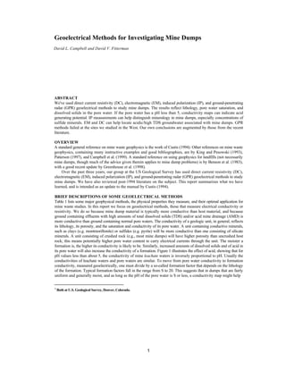
  • 5. There are some instances where geoelectric methods might fail, or where their results can be ambiguous. DeVos et al. (1997) tell of a case where AMD drained into a glaciated terrain containing many small pockets of electrically conducting clays. Li that place it was hard to separate conductivity highs due to the plume from those due to clay. Sinha (1994) and Busselli and Lu (1999) report instances where drainage appeared to be via fractures in shallow bedrock. In both places geoelectric surveys failed to find the plume. In general, attempts to use geophysics of any kind to delineate fluid-filled fractures may fail, because the physical properties of the large masses of country rock tend to mask those of the (volumetrically minor) fractures (cf, Emerson and Yang, 1999). In tracing plumes, one must remember that plumes may change with time in response to changing fluid heads at the source. (For an example documenting this kind of behavior with plumes of a gasoline spill, see Campbell et al., 1996). Patterson (1997) cites an instance where an EM survey of an AMD plume was repeated, finding a new lobe of the plume that had grown between surveys. Note, furthermore, that a film of pore water may coat grains that are situated well above the local water table. This leads to the possibility that high conductivities may be seen over fossil plumes — AMD plumes that have largely dried up, but have left conductive pore waters behind (Campbell et al., 1999). GEOPHYSICAL CHARACTERIZATION OF MINE WASTE PILES For reasons given above, material within mine waste piles is likely to be more electrically conducting than material making up their flanks or bases. When this is so, geoelectric methods can be useful for delineating waste pile boundaries. Geoelectric methods may also help to map features inside the piles, such as the water table or compositional variations. Choice of an optimal geoelectric method to investigate any particular mine pile will hinge on its depth and character. If the objective is merely to delineate the dump edges, it may be possible to hemstitch back and forth along its border with a EM system, dropping flags where the conductivity changes, just as one would do to map shallow plumes. Tezkan et al. (1996) used VLF in this way at a municipal landfill. To look for relatively horizontal boundaries, such as the water table or the base of a shallow waste pile, DC soundings (King and Pesowski, 1993) or multifrequency EM soundings (APEX Max-Min; Jansen et al., 1992) have been employed. In such cases, the individual soundings are separately interpreted using an appropriate computer program to give a layered structure at each site, and the results are then interpolated between sounding sites. In principle, it is possible to similarly interpret continuous multifrequency EM profiles, but efficient software to do so is only now becoming available. Limitations of the different geoelectric methods also play a role. General geophysical experience is that the DC and CSAMT methods are better at detecting extremely resistive layers, whereas multifrequency EM and especially TEM methods are better at detecting extremely conductive layers. This generalization fades, however, for units with only moderate electrical contrasts. The water table, for example, is usually somewhat more conductive than overlying unsaturated material. In the case of fresh ground water, it often happens that the water table is most readily detected by DC resistivity. Typical fresh water tables may be poor targets for EM methods because of the inability of these methods to differentiate between relatively high resistivity materials. However, when AMD is present or when the ground water contains high amounts of TDS, the water table can be a very conductive target that can be readily mapped by TEM or EM methods. Hence, one might choose DC or CSAMT if the primary objective were to find the (resistive) base of a dump, but multifrequency EM or TEM to accurately map the (conductive) water table within a dump. Carlson and Zonge (1997) emphasize the former point, clearly demonstrating that CSAMT is far better than TEM at mapping pre-dump topography now buried as much as 50 m deep. Tezkan et al. (1996) reach a similar conclusion in their study of a municipal landfill. This generalization is only a matter of degree, however. For practical applications, one probably could choose either method and use its interpreted depths for both water table and dump bottoms. Both CSAMT and conventional ground TEM methods are designed to focus well below the surface, so that they give poor resolution of very shallow geoelectrical features. Hence, one might use DC or multifrequency EM methods to investigate shallow dumps, and CSAMT or TEM to investigate deeper ones. Because well-calibrated multifrequency EM systems and good interpretation packages for them may be hard to locate, present-day practice dominantly uses the more readily-available DC systems to find both shallow resistive and conductive layers. Buselli et al. (1998; their Fig. 5) used 10 m as their crossover depth in choosing between DC and TEM to map water table depth in an Australian tailings deposit. IP methods can be useful for detailing makeup and mineralogy of mine dumps. Figure 2 (in the color appendix at the end of the book) shows interpreted conductivity (top) and IP phase (bottom) at the Yukon and May Day mine dumps, near Silverton, Colorado (also see Yaeger and Stanton, this volume). IP phase shift between transmitted and 5
  • 6. received signals is a measure of IP effect. The particular IP phase value contoured is that at 0.125 Hz, and represents one of several we measured in the field. Coordinates are in feet. The Yukon survey used 10-ft dipoles and the May Day survey used 5-ft dipoles; both measured S in-line receiver dipoles for each transmitter dipole. Both surveys were made on free dump faces having an angle of repose of about 35°; consequently, these sections look vertically into the faces at a median slant angle of some 55° from the horizontal. Note that the interpreted values shown represent conductivity and phase values for large blocks of ground and that the resolution of the interpretation becomes poorer with depth. The interpreted conductivity values at both dumps vary from approximately zero to more than 100 mS/m. The higher conductivity regions on these sections probably represent places in the dumps either where there are conductive minerals or where the pore waters have low pH, high TDS, or both (cf. Fig. 1). Waters draining from both dumps have pH values less than 3.0. Because such pore waters are probably in chemical equilibrium with nearby grains of dump material, these regions accordingly may reflect places where acid is being generated in the dumps. The interpreted IP phase values (bottom, Fig. 2) are very different at these two mine dumps. At the Yukon dump, there are local regions with phase values of more than SO mR. By contrast, at the May Day dump, phase values are low everywhere, generally less than 10 mR. The likely reason for this difference is illustrated in Figure 3, a plot of phase measurements made in the laboratory. Results are shown for four samples: two samples containing 1.96% pyrite ("2% Pyrite" and "Rusty 2%"), and two samples of May Day dump material ("Brown" and "Yellow", indicating color). X-ray diffraction analysis of the latter two samples showed they contained jarosite (a sulfate mineral), but negligible sulfides. The heavy vertical bar indicates the frequency of the raw IP phase value that was measured in the field and contoured in Figure 2 (see color section at the end of the book). From Figure 3, we might expect pyrite-bearing material to have high IP phase values. This is in line with general geophysical experience that metallic sulfides (e.g., pyrite, chacopyrite, galena, but not sphalerite) give strong IP responses. It seems likely, therefore, that the high IP phase regions in the Yukon Mine dump may contain concentrations of sulfides, whereas the lack of such high IF phase regions in the May Day Mine dump argues against polarizable sulfide concentrations there. We conclude that areas on Figure 2 having both high conductivity and high IP response may represent concentrations of sulfide minerals. Areas with high conductivity but low IP response may represent areas with sulfate minerals — also possible acid producers. Finally, areas with low conductivity but high IP response may represent mine junk. In particular, the area of the Yukon Mine dump at X = -85, Z = -10 was excavated and found to be rusting rebar in a crumbling cement block. The presence of the ferrous mine junk (rebar) had also been predicted by a magnetometer survey (not shown). SUMMARY AND CONSENSUS FINDINGS • Most mine dump material is electrically conductive relative to host materials forming dump edges and bottoms. Most ground containing AMD plumes is electrically conductive relative to ground containing uncontaminated ground water. Therefore, the geophysical methods of choice for investigating most mine dumps and AMD plumes are Geoelectrical. • EM methods are fast and cheap for screening for shallow AMD plumes in soil. They can fail when drainage is via fractures in bedrock, and their results can be ambiguous when the contaminated soil contains other electrical conductors such as clay lenses. Most commonly-used EM methods give only qualitative indications of depth to the plume. Repeat surveys of plumes are a good idea, in order to catch new lobes of evolving plumes. 6
  • 7. • CSAMT methods usually yield somewhat better determinations of depths to horizons that are very resistive. Similarly, TEM methods give somewhat better depths to very conducting horizons. Water in mine dumps and AMD plumes is typically much more conducting than ordinary ground water. Thus CSAMT is better for finding the bottoms of dumps, whereas TEM is better for finding deeper, conductive water tables within them. • DC soundings are good for finding electrical horizons at shallow depths, whereas TEM and CSAMT are designed to focus below the surface. Buselli et al. (1998; Fig. S) use 10 m as their crossover depth in choosing between the former and latter methods. Resolution of all three methods decreases with depth. Multifrequency EM systems hold promise to determine depths in lower resistivity materials such as mine waste piles, but to date they have not been used for this application. • Induced polarization (IP) work is likely to help distinguish mineralogy, especially sulfides vs. sulfates. • Magnetic measurements are mostly useful for locating ferrous junk in waste piles. No clear successes have yet been reported using magnetics in mine waste piles to map iron-fixing by microbes. • Ground-penetrating radar (GPR) is likely to be unsuccessful anywhere in the arid West. That is because mine dump material in the West is typically quite electrically conductive, leading to poor penetration of GPR waves. • No clear successes have yet been reported using spontaneous potential (SP) geoelectric voltages in mine waste work. REFERENCES Bauman, P.D., M. Lockhard, A. Sharma, and R. Kellett. 1997. Case studies of 2D resistivity surveying for soils waste management, geotechnical, and groundwater investigations. Proceedings of the Symposium on the Application of Geophysics to Engineering and Environmental Problems, March 23-26, 1997, Reno, Nevada,261-270. Bell, R.S., M.H. Powers, and T. Larson, eds., 1998. Proceedings of the Symposium on the Application of Geophysics to Environmental and Engineering Problems, March 22-26, 1998, Chicago IL, 1110 pps. Benson, A.K., and C.L. Addams. 1998. Detecting the presence of acid mine drainage using hydrological, geochemical, and geophysical data; applications to contrasting conditions at mine sites in Little Cottonwood and American Forks Canyons, Utah. Environmental Geosciences, 5(1): 17-27. Benson, Richard, R.A. Glaccum, and M.R. Noel. 1983. Geophysical techniques for sensing buried wastes and waste migration, 236p. 6375 Riverside Dr., Dublin OH 43107: National Ground Water Association. Bisdorf, R.J., and J.E. Lucius. 1999. Mapping the Norman. Oklahoma, landfill contaminant plume using electrical geophysics. U.S. Geological Survey Water-Resources Investigations Report 99-4018C, mmm-nn. Buselli, G., and H.S. Hwang. 1996. Electrical and electromagnetic surveys of a mine tailings dam at Brukunga, SA. CSIRO Exploration and Mining Report 277F, 53p. Buselli, G., H.S. Hwang, and K. Lu. 1998. Minesite groundwater contamination mapping. Exploration Geophysics, 29:296-300. Buselli, G. and K. Lu. 1999. Applications of some new techniques to detect groundwater contamination at mine tailings dams. Proceedings of the Symposium on the Application of Geophysics to Engineering and Environmental Problems, March 14-18,1999, Oakland, California, 507-516. Campbell, D.L., D.V. Fitterman, A.S. Hein, and D.P. Jones. 1998. Spectral induced polarization studies of mine dumps near Silverton, Colorado. Proceedings of the Symposium on the Application of Geophysics to Engineering and Environmental Problems, March 22-26,1998, Chicago, Illinois, 761-769. Campbell, D.L., R.J. Horton, R.J. Bisdorf, D.L. Fey, M.H. Powers, and D.V. Fitterman. 1999. Some geophysical methods for tailings/mine waste work. Tailings and Mine Waste '99, Proceedings of the Sixth International Conference, Fort Collins, Colorado, January 24-27,1999,35-43. Rotterdam: AA. Balkema. 35-43. Campbell, D.L., J.E. Lucius, K.J. Ellefsen, and M. Deszcz-Pan. 1996. Monitoring of a controlled LNAPL spill using ground-penetrating radar. Proceedings of the Symposium on the Application of Geophysics to Engineering and Environmental Problems, April 28-May 2,1996, Keystone, Colorado, 511-7. Campbell, D.L., J.C. Wynn, S.E. Box, AA. Bookstrom, and R.J. Horton. 1997. Tests of ground penetrating radar and induced polarization for mapping fluvial mine tailings on the floor of Coeur d'Alene River, Idaho. Proceedings of the Symposium on the Application of Geophysics to Engineering and Environmental Problems, March 23-26, 1997, Reno, Nevada, 81-87. Carlson, N.R., and K.L. Zonge. 1997. Case histories of electrical and electromagnetic geophysics for environmental applications at active mines. Proceedings of the Symposium on the Application of 7
  • 8. Geophysics to Engineering and Environmental Problems, March 23-26,1997, Reno, Nevada, 73-80. Conyers, L.B., and Dean Goodman. 1997. Ground-penetrating radar, 232p. Walnut Creek, California: Altamira Press. Corwin, R.F. 1990. The self-potential method for environmental and engineering applications, in Ward, S.H., ed., Geotechnical and Environmental Geophysics, v. /, 127-46. Tulsa, Oklahoma: Society of Exploration Geophysicists. Custis, Kit, 1994, Application of geophysics to acid mine drainage investigations, volume 1 — literature review and theoretical background, MS 09-06, 100p. 801 K Street, Sacramento CA 9S814-3529: California Department of Conservation, Office of Mine Reclamation. DeVos, K.J., P. Pehme, and J.P. Greenhouse. 1997. Ground geophysical surveys for mine wastes. In Proceedings of Exploration '97, Fourth Decennial International Conference on Mineral Exploration, ed. A.G. Gubbins, 917-26. Toronto: Prospectors and Developers Association of Canada. Draskovits, P. 1994. Application of induced polarization methods in integrated studies of ground water exploration and characterization of subsurface contamination. The John S. Sumner Memorial International Workshop on Induced Polarization (IP) in Mining and The Environment. Tucson AZ: Dept. Min. Geol., Univ. Arizona. Ebraheem, M.W., E.R. Bayless, and N.C. Krothke. 1990. A study of acid mine drainage using earth resistivity measurements. Ground Water, 28:361-368. Emerson, D.W., and Y.P. Yang. 1999. Physical properties of fractured rock—bulk resistivity. Preview, 77:26-7. Fink, J.B, E.O. McAlester, B.K. Sternberg, S.H. Ward, and W.G. Wieduwilt, eds. 1990. Induced Polarization, Applications and Case Histories, 414 p. Tulsa, Oklahoma: Society of Exploration Geophysicists. Frangos, W. 1997. Electrical detection of leaks in lined waste disposal ponds. Geophysics, 62:1737-44. Frangos, W., and T. Andrezal. 1994. IP measurements at contaminant and toxic waste sites in Slovakia. TheJohn S. Sumner Memorial International Workshop on Induced Polarization (IP) in Mining and The Environment. Tucson AZ: Dept. Min. Geol., Univ. Arizona. Freeman, K., J. Wright, and N. Phillips. 1997. Practical geophysical applications for everyday operational and engineering problems at Newmont Gold Company. Proceedings of the Symposium on the Application of Geophysics to Engineering and Environmental Problems, March 23-26,1997, Reno, Nevada, 53-56. Frohlich, Reinhard K., D.W. Urish, J. Fuller, and M. O'Reilly. 1994. Use of geoelectrical methods in groundwater pollution surveys in a coastal environment. Journal of Applied Geophysics, 32:139-54. Gamey, T. Jeffrey. 1998. Acid mine drainage in northern Ontario. In Geologic applications of gravity and magnetics: case histories, eds. R.I. Gibson and P.S. Mulligan, 112-3. SEG Geophysical Reference Series, no. 8, and AAPG Studies in Geology, no.43, Tulsa OK: Society of Exploration Geophysicists. Greenhouse, John, P. Pheme, D. Coulter, and Q. Yarie. 1998. Trends in geophysical site characterization. In Geotechnical site characterization—proceedings of the first international conference, Atlanta, Georgia, 19 -22 April, 1998, eds. P.K. Roberston and P.W. Mayne. 23-34. Gudjurgis, P.J., T.J. Katsube, and J. Gingerich. 1997. Complex resistivity characteristics of pyrite and clays altered by acid-mine-drainage contaminants: implications for monitoring of advancing contamination fronts. Expanded Abstracts With Biographies, Society of Exploration Geophysicists International Exposition and Sixty-Seventh Annual Meeting, November 2-7, 1997, Dallas TX, 1:344-47. Jansen, John, B. Haddad,, W. Fassbender, and P. Jurek. 1992. Frequency domain electromagnetic induction sounding surveys for landfill site characterization studies. Ground Water Monitoring Review, Fall 1992, p. 103-109. Keys, W. Scott. 1997. A practical guide to borehole geophysics in environmental investigations, 176 p. Boca Raton, Florida: CRC Press. King, Alan, and M.S. Pesowski. 1993. Environmental applications of surface and airborne geophysics in mining. CMBulletin, 86-966:58-67. Lanz, E.B., H. Maurer, and A.G. Green. 1997. Characterization of a composite landfill: a multidisciplinary approach. Expanded Abstracts With Biographies, Society of Exploration Geophysicists International Exposition and Sixty-Seventh Annual Meeting, November 2-7,1997, Dallas TX, 1:776-7. Lemke, S.R., and C.T. Young. 1998. Leachate plume investigations using mise-a-la-masse resistivity. Proceedings of the Symposium on the Application of Geophysics to Engineering and Environmental Problems, March 22-26,1998, Chicago, Illinois, 839-847. 8
  • 9. McNeill, J. Duncan. 1990. Use of electromagnetic methods for groundwater studies. In Geo technical and Environmental Geophysics, v. I, ed. S.H. Ward, 191-218. Tulsa, Oklahoma; Society of Exploration Geophysicists. Merkel, R.H. 1972. The use of resistivity techniques to delineate acid mine drainage in ground water: Ground Water, 10:38^*2. Monier-Williams, M., M. Maxwell, and G. Schneider. 1997. Preparing for waste: geophysics in geotechnical and environmental assessments of proposed mine waste facilities. In Proceedings of Exploration '97, Fourth Decennial International Conference on Mineral Exploration, ed. A.G. Gubbins, 893-904. Toronto: Prospectors and Developers Association of Canada. Paterson, Norman. 1997. Remote mapping of mine wastes. In Proceedings of Exploration '97, Fourth Decennial International Conference on Mineral Exploration, ed. A.G. Gubbins, 905-16. Toronto: Prospectors and Developers Association of Canada. Park, Stephen. 1998. Fluid migration in the vadose zone from 3-D inversion of resistivity monitoring data. Geophysics, 63:41-52. Phillips, G., and H. Maathius. 1997. Surface and downhole EM investigations at potash mine sites in Saskachewan, Canada: case histories. Proceedings of the Symposium on the Application of Geophysics to Engineering and Environmental Problems, March 23-26,1997, Reno, Nevada. 97-106. Roberston, P.K., T. Lunne, and J.J.M. Powell. 1998. Geo-environmental applications of penetration testing. In Geotechnical site characterization—proceedings of the first international conference, Atlanta, Georgia, 19 -22 April, 1998, eds. P.K. Robertson and P.W. Mayne, 35-48. Roberston, P.K., and P.W. Mayne. eds. 1998. Geotechnical site characterization—proceedings of the first international conference, Atlanta, Georgia, 19-22 April, 1998,1496 pp., 2 vols. Sato, M., and H.M. Mooney. 1960. The electrochemical mechanism of sulfide self-potentials. Geophysics, 25:226-9. Sinha, Ajit K. 1994. Ground electromagnetic surveys for environmental investigations at the Heath Steele mines area, New Brunswick. Current Research 1994-E; Geological Survey of Canada, 219-225. Tezkan, B., M. Goldman, S. Greinwald, A. Hordt, I. MĂĽller, F.M. Neubauer, and G. Zacher. 1996. A joint application of radiomagnetotellurics and transient electromagnetics to the investigation of a waste deposit in Cologne (Germany). Journal of Applied Geophysics, 34:199-212. Ward, Stanley H. 1990. Resistivity and induced polarization methods. In Geotechnical and Environmental Geophysics, v. II, ed. S.H. Ward, 147-190. Tulsa, Oklahoma: Society of Exploration Geophysicists. Wardlaw, S., and R. Wagner. 1994. Development of waste rock sampling protocol using induced polarization. CANMET-MSLDiv., 777-071, Final Rep. Ottawa: Nat. Resour. Can. White, C.C, and R.D. Barker. 1997. Electrical leak detection system for landfill liners: a case history. Ground Water Monitoring and Remediation. Summer 1997,153-9. Wynn, J.C. 1996. The Fort Chaffee (Arkansas) P.O.W. camp landfill—the geophysical surveys. http://minerals. usgs.gov/east/wvnn/4chaffee.html. Yuval and D.W. Oldenberg. 1996. DC resistivity and IP methods in acid mine drainage problems: results from the Copper Cliff mine tailing impoundments. Journal of Applied Geophysics, 34:187-98. Zonge Engineering. 1999. Down in the dumps: landfill characterization with an extremely fast IP method. Workshop notes from The Symposium on the Application of Geophysics to Engineering and Environmental Problems, March 15,1999, Oakland, California. 9
  • 10. Table 1 Geophysical methods used, or potentially useful, in mine waste studies. Method Measures Caused by Best Mine Waste Application EM, frequency-domain Electromagnetics Electrical Conductivity, mS/m Ground water, lithology ) Tracing AMD plumes (many references in bibliography DC, Direct Current Resistivity Electrical Resistivity, ohm-m Ground water, lithology Shallow (<10 m) water tables in, and bottoms of, shallow (<20 m) waste piles (Buselli et al., 1998) TEM, time-domain Electrical Conductivity, mS/m Ground water, lithology Deeper (10-30 m) water tables in mine piles (Buselli et al., 1998) Electromagnetic CSAMT, controlled source Electrical Resistivity, Ohm-m Ground water, lithology Deeper (10-S0m) bottoms of mine waste piles (Carlson and Zonge,1997) audio-magnetotellurics IP, Induced Polarization Electrical Chargeability, mV-sec/V; or others as described in text Electrochemical reactions at grain surfaces Concentrations of sulfides in mine piles. (Yuval and Oldenberg, 1996) SP, Spontaneous Polarization Ground voltages, mV Redox and streaming potentials Experimental. No proven successes. GPR, Ground-penetrating radar Speed of electromagnetic radiation, cm/ns Ground textures and included pore water Possibly, monitoring plume remediation. (Patterson, 1997) Magnetics (Campbell et al., 1999) Magnetic field, nT Magnetization Ferrous junk in mine piles. Other mine pile applications unproven. Seismic Acoustic wave velocity, m/s Compaction and ground water content Tracing bottoms and edges of waste piles (Lanz et al., 1997), basement under plume areas (DeVos et al., 1997). All mine waste applications are still in experimental stages. 10
  • 11. 11 Figure 2 Interpreted conductivity (top) and IP phase (an index of IP effect; bottom) at Yukon and May Day Mine dumps, near Silverton, Colorado. On these sections, areas with high conductivity may represent places within dumps where AMD is being generated. Areas with both high conductivity and high IP effect (Yukon) may represent areas of sulfide minerals. Areas with high conductivities but low IP effect (May Day) may represent areas with sulfate minerals, also possible AMD producers. Areas with low conductivity but high IP effect may represent mine junk.