SlideShare a Scribd company logo
1 of 8
Download to read offline
15-YEAR STATUS REPORT (2001-2016)
MATTAPOISETT RIVER VALLEY
LAND PROTECTION PARTNERSHIP
BUZZARDS BAY COALITION • MATTAPOISETT RIVER VALLEY WATER SUPPLY PROTECTION
ADVISORY COMMITTEE • TOWNS OF MARION, ROCHESTER, MATTAPOISETT AND FAIRHAVEN
THE CHALLENGE
Protecting our drinking water in
the Mattapoisett River Valley
The Mattapoisett River Valley, spanning from Snipatuit Pond in Rochester
to the Harbor in Mattapoisett, is one of southeastern Massachusetts
most important water resources. The river itself supports outdoor
recreation, an historically active herring run and a number of rare and
threatened plants and animals. But the river valley is just as important
for what you can’t see – the underlying aquifer that is the regional
drinking water supply for more than 24,000 people living in the towns
of Fairhaven, Mattapoisett, Marion and Rochester. Over the past 15
years, the Buzzards Bay Coalition has worked in close partnership with
these towns to proactively preserve the forests and wetlands along the
Mattapoisett forever.
The towns of Fairhaven and Mattapoisett get all of their public drinking
water from a series of wells within the Mattapoisett River Valley. The
towns manage this water supply along with the towns of Marion (60%
of town water) and Rochester who also withdraw water from the valley.
It is a clean, dependable source of drinking water, but protections for
the area from inappropriate land development are limited.
The most critical portion of this river valley is the 6,000 acres of land
closest to the wells from which we withdraw water – the recharge area
designated by the MA Department of Environmental Protection as the
“Zone II”. Protection of undeveloped lands within the Zone II is one of
the best and most cost effective ways to preserve the quality of drinking
water. Yet, 72% of land within the critical Zone II area around the wells,
remains unprotected from uses that might pollute the water supply.
OUR STRATEGY
Backin2000,thestatusofopenspaceprotectionwithintheMattapoisett
River Valley was exceptionally weak for such an important public
water supply. Despite some early land purchases by the Fairhaven,
Mattapoisett and Marion Water Departments immediately around their
well sites, only 8% of the land within the Mattapoisett River Valley
watershed was permanently protected from residential development
which could harm the water supply.
Nevertheless, land protection opportunities in the Mattapoisett River
Valley were strong. Much of the remaining undeveloped land exists in
large parcels that have been passed down for generations within local
families with solid land ethics and community ties. Forests and wetlands
continued to define the landscape and held the promise of a water
supply that could continue to safely supply these growing communities
for generations to come. The work ahead was in how best to get these
lands into permanent conservation.
Having already organized into the Mattapoisett River Valley Drinking
Water Supply Protection Advisory Committee with representatives
from each of the four communities withdrawing water from the valley,
the towns joined forces with the nonprofit Buzzards Bay Coalition
which had already begun work to protect land in the area for water
resource protection. Together the Coalition, the Advisory Committee
and town water officials began strategizing how to accelerate the pace
and amount of land being protected each year in the valley.
Fifteen years later, this report documents the outstanding success of
this partnership model. Since negotiating our first deals in 2001, the
Partnership has completed 27 separate real estate transactions resulting
in the permanent protection of 1,468 acres of Mattapoisett River Valley
Water Supply lands – a rate of nearly 100 acres each year.
THE MATTAPOISETT RIVER VALLEY &
ZONE II DRINKING WATER SUPPLY AREAS
1,468 ACRES
PROTECTED
Zone II
Mattapoisett
River Watershed
BETWEEN 2001-2016
98 ACRES PER YEAR – Doubled The Amount Of Protected Land
AS A RESULT, TODAY: 28% OF ZONE II PROTECTED
17% OF RIVER VALLEY PROTECTED
RIVER
VALLEY
RIVER VALLEY STATS
ZONE II
Mattapoisett
30%
The Mattapoisett River Valley (also called its Drainage Basin or Watershed)
contains 18,381 acres in five communities. The Mattapoisett River Zone II (6,000
acres) lies entirely within the River Valley. While all activities on the land within
the valley have the potential to harm our drinking water, those occurring within
the MA DEP-designated Zone II are most critical to protect. This is the primary
area where rainwater soaks into the ground to recharge the underlying aquifer
from which we draw our drinking water.
Rochester
46%
Acushnet
16%
Fairhaven – 4%
Middleborough – 4%
Mattapoisett
29%
Rochester
66%
Acushnet – 5%
Beyond the planning and fundraising, the day-to-day work of the Mattapoisett
River Valley Land Protection Partnership has been with the landowners
and families of this landscape – many of whom have owned these lands for
generations. The maps on the following pages show how these deals unfolded between 2001-2016.
Behind the labels and colors on the map are many of the foundation families of Old Rochester – the
Rounsevilles, Churches, and Tinkhams – and relative newcomers like the Decas, McIntryre, and Keeler
families. It has been our privilege to work with all of them to preserve not only the waters but the rural
character and beauty of the Mattapoisett River Valley.
Between 2001-2016, the Mattapoisett River Valley Land Protection Partnership
completed 27 separate real estate transactions with landowners willing to
sell or donate their land for conservation. All participation by landowners was
entirely voluntary.
In selecting deals to pursue, land immediately adjacent to wells was considered
a priority for outright acquisition to allow for the highest level of protection
of the water supply. Adjacent lands were considered suitable for protection
through Conservation Restricitions (CR). A CR is a permanent agreement
between a conservation nonprofit like the Buzzards Bay Coalition or a town
conservation commission or water department which prevents development
of land while allowing it to remain in private ownership.
The Mattapoisett River Valley straddles five communities – Mattapoisett,
Rochester, Fairhaven, Acushnet and Middleborough – but the vast majority of
the Valley and its critical Zone II lies in Rochester and Mattapoisett. Therefore,
the lands protected over the past fifteen years have mirrored this distribution.
As a regional water resource, what town boundary a parcel of land might
fall within matters much less than how that land contributes to the overall
protection of the water supply. As a result, many deals saw voters in Marion,
Mattapoisett and Fairhaven voting to spend their own town funds on lands in
other communities – a testament to the strength of this truly regional
water supply.
THE RESULTS Between 2001-2016, the Mattapoisett River Valley Land Protection Partnership
permanently protected 1,468 acres of land to maintain the quality and quantity
of our region’s drinking water supply. Four charts tell the story best.
Funding to acquire the lands and Conservation Restrictions featured in this
15-year report was split nearly equally between government grant (53%) and
private (47%) sources. The largest source of support came from generous
local landowners who agreed to sell their land for less than its Fair Market
Value in order to see the land protected. These ‘bargain sales’ of land totaled
$5,338,000 in donated value. The Buzzards Bay Coalition also raised $787,687
in gifts from individuals, families and foundations concerned about clean water.
On the government side, funding was divided almost equally between
local, state and federal sources. Town funding primarily came in the form of
contributions from the Mattapoisett River “Water Supply Protection Fund”
which collects approximately $75,000 each year as a user fee of one penny
per one hundred gallons used. Since 2010, these local funds have been
supplemented with Community Preservation Funds in the towns of Fairhaven,
Mattapoisett and Marion.
The Buzzards Bay Coalition coordinated State and Federal Grant applications,
usually in close partnership with a municipal applicant. Most notable among
these programs were MA DEP Drinking Water Supply Protection Grants and
the US Department of Agriculture’s Wetland Reserve Program.
In selecting lands for protection, first priority was placed on properties within the
Zone II Recharge Area for the Mattapoisett River Valley municipal wells system.
These areas have been determined to most directly recharge the groundwater
around the wells so their protection is most important to maintaining both water
quality and quantity. Second priority was granted to forest and wetlands. These
areas are powerful pollution filters, help maintain soil and water temperatures,
reduce stormwater runoff and encourage groundwater recharge, and provide
wildlife habitat. The cranberry bogs acquired are immediately adjacent to two
important wells and were removed from cultivation in order to prevent potential
pollution from fertilizers, pesticides and herbicides and restore natural water
flows both of which further support the maintenance of healthy drinking water.
THE DEALS
$13M
MA State Grants
$1,890,200
15%
Federal Grants
$2,880,513
22%
Town Funding
$2,019,257
16% Private Funds
$787,687
6%
Landowner Bargains Sales
& Gifts of Land
$5,338,200
41%
1,468
acres
Freshwater
Wetland
597 acres
41%
Upland
Forest
789 acres
54%
Cranberry Bog – 53 acres – 4%
Agricultural Fields – 4 acres – 0%
Non-Farm Open Land – 20 acres – 1%
27
Deals
Outright Fee
Acquisition
898 acres
61%
Conservation
Restrictions
571 acres
39%
4
Towns
Rochester
768 acres
52%
Mattapoisett
598 acres
41%
Fairhaven – 67 acres – 5%
Acushnet – 35 acres – 2%
Beyond the planning and fundraising, the day-to-day work of the Mattapoisett
River Valley Land Protection Partnership has been with the landowners
and families of this landscape – many of whom have owned these lands for
generations. The maps on the following pages show how these deals unfolded between 2001-2016.
Behind the labels and colors on the map are many of the foundation families of Old Rochester – the
Rounsevilles, Churches, and Tinkhams – and relative “newcomers” like the Decas Cranberry Company,
and the McIntire and Keeler families. It has been our privilege to work with all of them to preserve not
only the waters but the rural character and beauty of the Mattapoisett River Valley.
THE DEALS
^
^^
Mattapoisett
Harbor
Snipatuit
Pond
ROCHESTER
MATTAPOISETT
MIDDLEBOROUGH
ROCHESTER
ROCHESTER
ACUSHNET
MATTAPOISETT
FAIRHAVEN
MATTAPOISETT
ACUSHNET
15-YEAR STATUS REPORT (2001-2016)
MATTAPOISETT RIVER VALLEY LAND PROTECTION PARTNERSHIP
BUZZARDS BAY COALITION & MATTAPOISETT RIVER VALLEY WATER SUPPLY PROTECTION ADVISORY COMMITTEE2001
2001BaselineYear
DEP-Approved Public Water Suppy Wells
Mattapoisett River Valley Watershed
Municipal Boundaries
DEP Core Wetland Resources
Existing Protected Lands
DEP Drinking Water Zone II
Assessors’ Parcels
DEP-Approved Public Water Supply Wells
Mattapoisett River Valley Watershed
Municipal Boundaries
DEP Core Wetland Resources
Existing Protected Lands
DEP Drinking Water Zone II
Assessors' Parcels
0 1 20.5
Miles
Data Sources: MassGIS &Buzzards Bay NEP
DEP-Approved Public Water Supply Wells
Mattapoisett River Valley Watershed
Municipal Boundaries
DEP Core Wetland Resources
Existing Protected Lands
DEP Drinking Water Zone II
Assessors' Parcels
0 1 20.5
Miles
Data Sources: MassGIS &Buzzards Bay NEP
Data Sources: MassGIS & Buzzards Bay National Estuary Program
Snipatuit
Pond
ROCHESTER
MATTAPOISETT
MIDDLEBOROUGH
ROCHESTER
ROCHESTER
ACUSHNET
MATTAPOISETT
FAIRHAVEN
MATTAPOISETT
ACUSHNET
Rounseville North (Phase II)
2005
164 acres
Rounseville South (Phase I)
2002
241 acres
Church
2005
163 acres
Tinkham Lands
2006
75 acres
Willoughby
2002
16 acresTinkham Lands
2005
35 acres
DEP-Approved Public Water Suppy Wells
Mattapoisett River Valley Watershed
Municipal Boundaries
BBC Partnership Projects
DEP Core Wetland Resources
Existing Protected Lands
DEP Drinking Water Zone II
Assessors’ Parcels
15-YEAR STATUS REPORT (2001-2016)
MATTAPOISETT RIVER VALLEY LAND PROTECTION PARTNERSHIP
BUZZARDS BAY COALITION & MATTAPOISETT RIVER VALLEY WATER SUPPLY PROTECTION ADVISORY COMMITTEE2006
Rounseville North (Phase II)
2005
164 acres
Rounseville South (Phase I)
2002
241 acres
Church
2005
163 acres
Tinkham Lands
2006
75 acres
Willoughby
2002
16 acresTinkham Lands
2005
35 acres
DEP-Approved Public Water Supply Wells
Mattapoisett River Valley Watershed
Municipal Boundaries
DEP Core Wetland Resources
Existing Protected Lands
DEP Drinking Water Zone II
Assessors' Parcels
0 1 20.5
Miles
Data Sources: MassGIS &Buzzards Bay NEP
DEP-Approved Public Water Supply Wells
Mattapoisett River Valley Watershed
Municipal Boundaries
DEP Core Wetland Resources
Existing Protected Lands
DEP Drinking Water Zone II
Assessors' Parcels
0 1 20.5
Miles
Data Sources: MassGIS &Buzzards Bay NEP
Data Sources: MassGIS & Buzzards Bay National Estuary Program
DEP-Approved Public Water Suppy Wells
Mattapoisett River Valley Watershed
Municipal Boundaries
BBC Partnership Projects
DEP Core Wetland Resources
Existing Protected Lands
DEP Drinking Water Zone II
Assessors’ Parcels
15-YEAR STATUS REPORT (2001-2016)
MATTAPOISETT RIVER VALLEY LAND PROTECTION PARTNERSHIP
BUZZARDS BAY COALITION & MATTAPOISETT RIVER VALLEY WATER SUPPLY PROTECTION ADVISORY COMMITTEE2011
Mattapoisett
Harbor
Snipatuit
Pond
ROCHESTER
MATTAPOISETT
MIDDLEBOROUGH
ROCHESTER
ROCHESTER
ACUSHNET
MATTAPOISETT
FAIRHAVEN
MATTAPOISETT
ACUSHNET
Gaumont
2007
7 acres
Red Barn Farm (Keeler)
2007
60 acres
MacPhail
2009
12.5 acres
Rounseville
2009
30 acres
Gurney
2009
17 acres
Fitzgerald
2009
8 acres
Mahoney Wells
2010
20 acres
Church Mattapoisett Road
2010
32 acres
Rentumis
2011
54.2 acres
Mahoney Wolf Island Road
2011
18 acresMahoney New Boston Road
2011
0.31 acre
Mahoney New Boston Road
2011
59 acres
Mahoney Wolf Island Road
2011
10 acres
Dufficy-Lawrence
2011
7.5 acres
Decas Tripp Mill
2011
42.67 acres
Decas Bogs
2011
125 acres
Mahoney Brook Parcel
2010
24 acres
DEP-Approved Public Water Supply Wells
Mattapoisett River Valley Watershed
Municipal Boundaries
DEP Core Wetland Resources
Existing Protected Lands
DEP Drinking Water Zone II
Assessors' Parcels
0 1 20.5
Miles
Data Sources: MassGIS &Buzzards Bay NEP
DEP-Approved Public Water Supply Wells
Mattapoisett River Valley Watershed
Municipal Boundaries
DEP Core Wetland Resources
Existing Protected Lands
DEP Drinking Water Zone II
Assessors' Parcels
0 1 20.5
Miles
Data Sources: MassGIS &Buzzards Bay NEP
Data Sources: MassGIS & Buzzards Bay National Estuary Program
Mattapoisett
Harbor
Snipatuit
Pond
ROCHESTER
MATTAPOISETT
MIDDLEBOROUGH
ROCHESTER
ROCHESTER
ACUSHNET
MATTAPOISETT
FAIRHAVEN
MATTAPOISETT
ACUSHNET
Mattapoisett Riverfront
2015
16.5 acres
Mahoney Town Line
2012
63 acres
North Woods
2013
33 acres
Tinkham Woodlands
2016
47.7 acres
Tinkham Woodlands
2016
86.94 acres
Roy-Hawkes
Under Agreement
164 acres
DEP-Approved Public Water Supply Wells
Mattapoisett River Valley Watershed
Municipal Boundaries
DEP Core Wetland Resources
Existing Protected Lands
DEP Drinking Water Zone II
Assessors' Parcels
0 1 20.5
Miles
Data Sources: MassGIS &Buzzards Bay NEP
DEP-Approved Public Water Supply Wells
Mattapoisett River Valley Watershed
Municipal Boundaries
DEP Core Wetland Resources
Existing Protected Lands
DEP Drinking Water Zone II
Assessors' Parcels
0 1 20.5
Miles
Data Sources: MassGIS &Buzzards Bay NEPDEP-Approved Public Water Suppy Wells
Mattapoisett River Valley Watershed
Municipal Boundaries
BBC Partnership Projects
DEP Core Wetland Resources
Existing Protected Lands
DEP Drinking Water Zone II
Assessors’ Parcels
Data Sources: MassGIS & Buzzards Bay National Estuary Program
15-YEAR STATUS REPORT (2001-2016)
MATTAPOISETT RIVER VALLEY LAND PROTECTION PARTNERSHIP
BUZZARDS BAY COALITION & MATTAPOISETT RIVER VALLEY WATER SUPPLY PROTECTION ADVISORY COMMITTEE2016
Mattapoisett Riverfront
2015
16.5 acres
Mahoney Town Line
2012
63 acres
North Woods
2013
33 acres
Tinkham Woodlands
2016
47.7 acres
Tinkham Woodlands
2016
86.94 acres
Roy-Hawkes
Under Agreement
164 acres
THE PROJECTS
Depending on the characteristics of the land, wishes of landowners, and available funding sources, each deal resulted
in slightly different land protection outcomes. Lands destined for walking trail networks, hunting and fishing, and canoe
access were prioritized for ownership by the Buzzards Bay Coalition who committed to manage the land for responsible
public use into the future. Lands close to wells were acquired by town Water Departments, and private lands were protected
with Conservation Restrictions (CRs). This flexible approach to each individual deal has been one of the hallmarks of
this partnership and will continue in the years ahead. What is common to every transaction, however, is that the land is
protected from development forever – usually through multiple reinforcing land ownership and CR agreements.
THE BENEFITS
Protecting Water Quality
The forests and wetlands of Mattapoisett River Valley work together
to shield the river and the valley aquifer from excess nitrogen and
other pollutants. When development and urbanization threaten
the natural spaces that filter out pollutants and prevent them from
entering the water supply, the overall quality of the water in the
valley can be degraded. This manifests through an increase in
contaminantsenteringthewatershed,whichcanincludewastewater
from residential septic systems, pesticides and fertilizers from lawns
and gardens, road salts, and heavy metals. Permanent protection
of this land sustains the essential natural areas that protect against
contamination, safeguarding clean drinking water for more than
24,000 people and ensuring that the Mattapoisett River Valley
drinking water supply will remain healthy for generations to come. 
Maintaining Water Quantity
In the Mattapoisett River Valley, the aquifer is maintained as water
soaks into the ground after rainfall. The area in which this occurs is
known as the recharge area, or Zone II (See map on page 1). However,
72% of land in Zone II is not currently protected from development,
which threatens the pervious surfaces that allow water to soak into
the ground in the recharge area. Housing developments, driveways
and roads are all examples of impervious surfaces resulting from
development that decrease the base flow reaching the aquifer.
Protecting land around the Mattapoisett River Valley recharge
area safeguards against the construction of impervious surfaces,
ensuring that the base flow sustaining the aquifer will be protected
and that there will be an adequate supply of clean water for all.
Expanding Outdoor Recreation
Protecting land in the Mattapoisett River Valley does more than
safeguard against ecological threats—it also provides additional
recreational spaces and opportunities for local residents. On much
of the land that has been protected in the valley, the public is
welcome to explore the preserved areas and engage in passive
recreation opportunities. Depending on the site, visitors can enjoy
miles of walking trails, fish, birdwatch, cross-country ski, hunt,
and more. Preserving land around the Mattapoisett River Valley
affords residents the chance to get outdoors and enjoy the natural
beauty of the South Coast—just steps from their homes, offices, and
schools. It also ensures that their children and grandchildren will be
able to experience the unspoiled magnificence of the area.
Preserving Fish and Wildlife
Preserving open space also benefits the animals and plants that
call the Mattapoisett River Valley home. Much is at stake—the
Mattapoisett River has historically been home to one of the largest
herring populations on Buzzards Bay with thousands of herring
migrating up the river to spawn each year. Other species, such as
shad, sturgeon, and Atlantic salmon are entirely gone from the
region.Onland,thevalleyishometoanumberofrareandthreatened
species of plants and animals with much of the area mapped by
the state as Priority Habitat. Therefore, it is imperative to preserve
large, contiguous areas of open space in the Mattapoisett River
Valley to protect the well-being of keystone species threatened by
habitat degradation and fragmentation. 
YEAR PROJECT NAME TOWN TOTAL
ACRES
LAND PROTECTION OUTCOME
OWNERSHIP CONSERVATION RESTRICTION HOLDER(S)
2002 Willoughby Mattapoisett 16 Mattapoisett Conservation Commission
2002 Rounseville Homestead South Rochester 241 Private Rochester Land Trust & Marion Water Department
2005 Tinkham Pond lands Acushnet 35 Fairhaven-Acushnet Land Preservation Trust
2005 Rounseville Homestead North Rochester 164 Private Wildlands Trust & Rochester Conservation Commission
2005 Church Homestead Rochester 163 MA Division of Fish & Game
2006 Tinkham Lands Mattapoisett 75 Mattapoisett Water Department
2007 Gaumont Farm Rochester 7 Private Buzzards Bay Coaltion & Rochester Land Trust
2007 Red Barn Farm Rochester 60 Private Buzzards Bay Coaltion & Rochester Land Trust
2009 Fitzgerald Fairhaven 8 Fairhaven Conservation Commission Buzzards Bay Coaltion
2009 Rounseville woodlot Mattapoisett 30 Mattapoisett Water Department
2009 MacPhail Rochester 12.5 Private Buzzards Bay Coaltion & Rochester Land Trust
2009 Gurney Rochester/Mattapoisett 17 Private Buzzards Bay Coaltion & Rochester Land Trust
2010 Mahoney Brook Parcel Mattapoisett 24 Buzzards Bay Coalition Mattapoisett Conservation Commission CR
2010 Mahoney Wells Mattapoisett 20 Mattapoisett Water Department
2010 Church Mattapoisett Road Rochester 32 Rochester Land Trust
2011 Mahoney New Boston Road Acushnet 0.31 Buzzards Bay Coalition
2011 Mahoney New Boston Road Fairhaven 59 Fairhaven Conservation Commission Buzzards Bay Coalition
2011 Mahoney Wolf Island Road Mattapoisett 18 Mattapoisett Water Department Fairhaven Water Department
2011 Decas Tripps Mill Mattapoisett 42.67 Mattapoisett Conservation Commission Buzzards Bay Coalition
2011 Decas Bogs Mattapoisett 125 Buzzards Bay Coalition USDA Natural Resources Conservation Service
2011 Rentumis Rochester 54.2 Marion Water Department Buzzards Bay Coalition
2011 Mahoney Wolf Island Road Rochester 10 Rochester Conservation Commission Fairhaven Water Department
2011 Dufficy-Lawrence Rochester 7.5 Private Buzzards Bay Coaltion & Rochester Land Trust
2012 Town Line Lots Mattapoisett 63 Buzzards Bay Coalition Mattapoisett Conservation Commission
2013 North Woods Mattapoisett 33 Mattapoisett Conservation Commission Buzzards Bay Coalition
2015 Mattapoisett Riverfront Mattapoisett 16.6 Mattapoisett Conservation Commission Buzzards Bay Coalition
2016 Tinkhamtown Woodlands I Mattapoisett 115.3 Mattapoisett Water Department Buzzards Bay Coalition, Fairhaven Water and Marion Water Depts
2016 Tinkhamtown Woodlands II Mattapoisett 19.3 Buzzards Bay Coalition
1,468
In Closing,
In the past fifteen years, the Buzzards Bay Coalition, working in close
partnership with the Mattapoisett River Valley Water Supply Protection
Advisory Committee, has made extraordinary progress toward the
permanent protection of our drinking water. 1,468 acres of land were
preserved around our wells between 2001-2016. The model created
for this work leveraged local government funding for drinking water
supply protection by six times, making it possible to protect land in
the Mattapoisett River Valley at a rate of nearly 100 acres per year.
This critical work continues today with much more land in need of
protection around our wells.
114 Front St. New Bedford, MA 02740
(508) 999-6363 | www.savebuzzardsbay.org
Dedicated to the restoration, protection
and sustainable use and enjoyment of
our irreplaceable Bay and its watershed. P.O. Box 1055 | Mattapoisett, MA 02739 | www.mrvwspac.org
Managing Water
Resources For Our
Future and Protecting
the Aquifer for
Fairhaven, Marion,
Mattapoisett &
Rochester
PHOTOS: THIS PAGE – TIM SYLVIA, FRONT – SIPPICAN WEEK

More Related Content

More from Buzzards Bay Coalition

Buzzards Bay Coalition 2014 Annual Report
Buzzards Bay Coalition 2014 Annual ReportBuzzards Bay Coalition 2014 Annual Report
Buzzards Bay Coalition 2014 Annual ReportBuzzards Bay Coalition
 
Solutions to Nitrogen Pollution: Solving the Cranberry Puzzle
Solutions to Nitrogen Pollution: Solving the Cranberry PuzzleSolutions to Nitrogen Pollution: Solving the Cranberry Puzzle
Solutions to Nitrogen Pollution: Solving the Cranberry PuzzleBuzzards Bay Coalition
 
Case Study: Educating Residents about Nitrogen Pollution
Case Study: Educating Residents about Nitrogen PollutionCase Study: Educating Residents about Nitrogen Pollution
Case Study: Educating Residents about Nitrogen PollutionBuzzards Bay Coalition
 
Buzzards Bay Coalition 2013 Annual Report
Buzzards Bay Coalition 2013 Annual ReportBuzzards Bay Coalition 2013 Annual Report
Buzzards Bay Coalition 2013 Annual ReportBuzzards Bay Coalition
 
Solving the Stormwater Management Puzzle
Solving the Stormwater Management PuzzleSolving the Stormwater Management Puzzle
Solving the Stormwater Management PuzzleBuzzards Bay Coalition
 
The Toolbox for Clean Water Construction
The Toolbox for Clean Water ConstructionThe Toolbox for Clean Water Construction
The Toolbox for Clean Water ConstructionBuzzards Bay Coalition
 
Rain Garden Design, Installation and Maintenance
Rain Garden Design, Installation and MaintenanceRain Garden Design, Installation and Maintenance
Rain Garden Design, Installation and MaintenanceBuzzards Bay Coalition
 
Clean Water in Real Estate Development
Clean Water in Real Estate DevelopmentClean Water in Real Estate Development
Clean Water in Real Estate DevelopmentBuzzards Bay Coalition
 
Thinking About Clean Water and Development
Thinking About Clean Water and DevelopmentThinking About Clean Water and Development
Thinking About Clean Water and DevelopmentBuzzards Bay Coalition
 
BioBarrier Membrane Bioreactor brochure
BioBarrier Membrane Bioreactor brochureBioBarrier Membrane Bioreactor brochure
BioBarrier Membrane Bioreactor brochureBuzzards Bay Coalition
 
Amphidrome Waste Water Treatment System flyer
Amphidrome Waste Water Treatment System flyerAmphidrome Waste Water Treatment System flyer
Amphidrome Waste Water Treatment System flyerBuzzards Bay Coalition
 
Nitrex(TM) Passive Nitrogen Removal Systems flyer
Nitrex(TM) Passive Nitrogen Removal Systems flyerNitrex(TM) Passive Nitrogen Removal Systems flyer
Nitrex(TM) Passive Nitrogen Removal Systems flyerBuzzards Bay Coalition
 

More from Buzzards Bay Coalition (20)

2015 Bay Current
2015 Bay Current2015 Bay Current
2015 Bay Current
 
Buzzards Bay Coalition 2014 Annual Report
Buzzards Bay Coalition 2014 Annual ReportBuzzards Bay Coalition 2014 Annual Report
Buzzards Bay Coalition 2014 Annual Report
 
Solutions to Nitrogen Pollution: Solving the Cranberry Puzzle
Solutions to Nitrogen Pollution: Solving the Cranberry PuzzleSolutions to Nitrogen Pollution: Solving the Cranberry Puzzle
Solutions to Nitrogen Pollution: Solving the Cranberry Puzzle
 
2014 Bay Current
2014 Bay Current2014 Bay Current
2014 Bay Current
 
Red Brook Harborview
Red Brook HarborviewRed Brook Harborview
Red Brook Harborview
 
Case Study: Educating Residents about Nitrogen Pollution
Case Study: Educating Residents about Nitrogen PollutionCase Study: Educating Residents about Nitrogen Pollution
Case Study: Educating Residents about Nitrogen Pollution
 
Cape Cod 208 Plan Summary
Cape Cod 208 Plan SummaryCape Cod 208 Plan Summary
Cape Cod 208 Plan Summary
 
Buzzards Bay Coalition 2013 Annual Report
Buzzards Bay Coalition 2013 Annual ReportBuzzards Bay Coalition 2013 Annual Report
Buzzards Bay Coalition 2013 Annual Report
 
Water Quality and Shellfish Areas
Water Quality and Shellfish AreasWater Quality and Shellfish Areas
Water Quality and Shellfish Areas
 
Solving the Stormwater Management Puzzle
Solving the Stormwater Management PuzzleSolving the Stormwater Management Puzzle
Solving the Stormwater Management Puzzle
 
Clean Water Landscaping
Clean Water LandscapingClean Water Landscaping
Clean Water Landscaping
 
Case Study of a Shared Septic System
Case Study of a Shared Septic SystemCase Study of a Shared Septic System
Case Study of a Shared Septic System
 
The Toolbox for Clean Water Construction
The Toolbox for Clean Water ConstructionThe Toolbox for Clean Water Construction
The Toolbox for Clean Water Construction
 
Rain Garden Design, Installation and Maintenance
Rain Garden Design, Installation and MaintenanceRain Garden Design, Installation and Maintenance
Rain Garden Design, Installation and Maintenance
 
Clean Water in Real Estate Development
Clean Water in Real Estate DevelopmentClean Water in Real Estate Development
Clean Water in Real Estate Development
 
Strategies for Urban Development
Strategies for Urban DevelopmentStrategies for Urban Development
Strategies for Urban Development
 
Thinking About Clean Water and Development
Thinking About Clean Water and DevelopmentThinking About Clean Water and Development
Thinking About Clean Water and Development
 
BioBarrier Membrane Bioreactor brochure
BioBarrier Membrane Bioreactor brochureBioBarrier Membrane Bioreactor brochure
BioBarrier Membrane Bioreactor brochure
 
Amphidrome Waste Water Treatment System flyer
Amphidrome Waste Water Treatment System flyerAmphidrome Waste Water Treatment System flyer
Amphidrome Waste Water Treatment System flyer
 
Nitrex(TM) Passive Nitrogen Removal Systems flyer
Nitrex(TM) Passive Nitrogen Removal Systems flyerNitrex(TM) Passive Nitrogen Removal Systems flyer
Nitrex(TM) Passive Nitrogen Removal Systems flyer
 

Recently uploaded

Delivering nature-based solution outcomes by addressing policy, institutiona...
Delivering nature-based solution outcomes by addressing  policy, institutiona...Delivering nature-based solution outcomes by addressing  policy, institutiona...
Delivering nature-based solution outcomes by addressing policy, institutiona...CIFOR-ICRAF
 
办理德州理工大学毕业证书TTU文凭学位证书
办理德州理工大学毕业证书TTU文凭学位证书办理德州理工大学毕业证书TTU文凭学位证书
办理德州理工大学毕业证书TTU文凭学位证书zdzoqco
 
Along the Lakefront, "Menacing Unknown"s
Along the Lakefront, "Menacing Unknown"sAlong the Lakefront, "Menacing Unknown"s
Along the Lakefront, "Menacing Unknown"syalehistoricalreview
 
Dwarka Call Girls 9643097474 Phone Number 24x7 Best Services
Dwarka Call Girls 9643097474 Phone Number 24x7 Best ServicesDwarka Call Girls 9643097474 Phone Number 24x7 Best Services
Dwarka Call Girls 9643097474 Phone Number 24x7 Best Servicesnajka9823
 
Gwalior Call Girls 7001305949 WhatsApp Number 24x7 Best Services
Gwalior Call Girls 7001305949 WhatsApp Number 24x7 Best ServicesGwalior Call Girls 7001305949 WhatsApp Number 24x7 Best Services
Gwalior Call Girls 7001305949 WhatsApp Number 24x7 Best Servicesnajka9823
 
办理学位证(KU证书)堪萨斯大学毕业证成绩单原版一比一
办理学位证(KU证书)堪萨斯大学毕业证成绩单原版一比一办理学位证(KU证书)堪萨斯大学毕业证成绩单原版一比一
办理学位证(KU证书)堪萨斯大学毕业证成绩单原版一比一F dds
 
Environmental Management System - ISO 14001:2015-
Environmental Management System      - ISO 14001:2015-Environmental Management System      - ISO 14001:2015-
Environmental Management System - ISO 14001:2015-Kawther MEKNI
 
Kavade Mala Call Girls 7001305949 ꧂Enjoy Escorts Service
Kavade Mala Call Girls 7001305949 ꧂Enjoy Escorts ServiceKavade Mala Call Girls 7001305949 ꧂Enjoy Escorts Service
Kavade Mala Call Girls 7001305949 ꧂Enjoy Escorts Serviceneha mumbai
 
办理(Victoria毕业证书)维多利亚大学毕业证成绩单原版一比一
办理(Victoria毕业证书)维多利亚大学毕业证成绩单原版一比一办理(Victoria毕业证书)维多利亚大学毕业证成绩单原版一比一
办理(Victoria毕业证书)维多利亚大学毕业证成绩单原版一比一z xss
 
9873940964 High Profile Call Girls Delhi |Defence Colony ( MAYA CHOPRA ) DE...
9873940964 High Profile  Call Girls  Delhi |Defence Colony ( MAYA CHOPRA ) DE...9873940964 High Profile  Call Girls  Delhi |Defence Colony ( MAYA CHOPRA ) DE...
9873940964 High Profile Call Girls Delhi |Defence Colony ( MAYA CHOPRA ) DE...Delhi Escorts
 
Call In girls Connaught Place (DELHI)⇛9711147426🔝Delhi NCR
Call In girls Connaught Place (DELHI)⇛9711147426🔝Delhi NCRCall In girls Connaught Place (DELHI)⇛9711147426🔝Delhi NCR
Call In girls Connaught Place (DELHI)⇛9711147426🔝Delhi NCRjennyeacort
 
Spiders by Slidesgo - an introduction to arachnids
Spiders by Slidesgo - an introduction to arachnidsSpiders by Slidesgo - an introduction to arachnids
Spiders by Slidesgo - an introduction to arachnidsprasan26
 
Making a Difference: Understanding the Upcycling and Recycling Difference
Making a Difference: Understanding the Upcycling and Recycling DifferenceMaking a Difference: Understanding the Upcycling and Recycling Difference
Making a Difference: Understanding the Upcycling and Recycling DifferenceSwag Cycle
 
Philippines-Native-Chicken.pptx file copy
Philippines-Native-Chicken.pptx file copyPhilippines-Native-Chicken.pptx file copy
Philippines-Native-Chicken.pptx file copyKristineRoseCorrales
 
办理La Trobe学位证(文凭证书)拉筹伯大学毕业证成绩单原版一模一样
办理La Trobe学位证(文凭证书)拉筹伯大学毕业证成绩单原版一模一样办理La Trobe学位证(文凭证书)拉筹伯大学毕业证成绩单原版一模一样
办理La Trobe学位证(文凭证书)拉筹伯大学毕业证成绩单原版一模一样umasea
 
See How do animals kill their prey for food
See How do animals kill their prey for foodSee How do animals kill their prey for food
See How do animals kill their prey for fooddrsk203
 
Call Girls Ahmedabad 7397865700 Ridhima Hire Me Full Night
Call Girls Ahmedabad 7397865700 Ridhima Hire Me Full NightCall Girls Ahmedabad 7397865700 Ridhima Hire Me Full Night
Call Girls Ahmedabad 7397865700 Ridhima Hire Me Full Nightssuser7cb4ff
 
earthquake drill seminar for schools.pptx
earthquake drill  seminar for schools.pptxearthquake drill  seminar for schools.pptx
earthquake drill seminar for schools.pptxBfpSiniloanFSLaguna
 
AI and Ecology - The H4rmony Project.pptx
AI and Ecology - The H4rmony Project.pptxAI and Ecology - The H4rmony Project.pptx
AI and Ecology - The H4rmony Project.pptxNeoV2
 

Recently uploaded (20)

Delivering nature-based solution outcomes by addressing policy, institutiona...
Delivering nature-based solution outcomes by addressing  policy, institutiona...Delivering nature-based solution outcomes by addressing  policy, institutiona...
Delivering nature-based solution outcomes by addressing policy, institutiona...
 
办理德州理工大学毕业证书TTU文凭学位证书
办理德州理工大学毕业证书TTU文凭学位证书办理德州理工大学毕业证书TTU文凭学位证书
办理德州理工大学毕业证书TTU文凭学位证书
 
Along the Lakefront, "Menacing Unknown"s
Along the Lakefront, "Menacing Unknown"sAlong the Lakefront, "Menacing Unknown"s
Along the Lakefront, "Menacing Unknown"s
 
Dwarka Call Girls 9643097474 Phone Number 24x7 Best Services
Dwarka Call Girls 9643097474 Phone Number 24x7 Best ServicesDwarka Call Girls 9643097474 Phone Number 24x7 Best Services
Dwarka Call Girls 9643097474 Phone Number 24x7 Best Services
 
Gwalior Call Girls 7001305949 WhatsApp Number 24x7 Best Services
Gwalior Call Girls 7001305949 WhatsApp Number 24x7 Best ServicesGwalior Call Girls 7001305949 WhatsApp Number 24x7 Best Services
Gwalior Call Girls 7001305949 WhatsApp Number 24x7 Best Services
 
Escort Service Call Girls In Shakti Nagar, 99530°56974 Delhi NCR
Escort Service Call Girls In Shakti Nagar, 99530°56974 Delhi NCREscort Service Call Girls In Shakti Nagar, 99530°56974 Delhi NCR
Escort Service Call Girls In Shakti Nagar, 99530°56974 Delhi NCR
 
办理学位证(KU证书)堪萨斯大学毕业证成绩单原版一比一
办理学位证(KU证书)堪萨斯大学毕业证成绩单原版一比一办理学位证(KU证书)堪萨斯大学毕业证成绩单原版一比一
办理学位证(KU证书)堪萨斯大学毕业证成绩单原版一比一
 
Environmental Management System - ISO 14001:2015-
Environmental Management System      - ISO 14001:2015-Environmental Management System      - ISO 14001:2015-
Environmental Management System - ISO 14001:2015-
 
Kavade Mala Call Girls 7001305949 ꧂Enjoy Escorts Service
Kavade Mala Call Girls 7001305949 ꧂Enjoy Escorts ServiceKavade Mala Call Girls 7001305949 ꧂Enjoy Escorts Service
Kavade Mala Call Girls 7001305949 ꧂Enjoy Escorts Service
 
办理(Victoria毕业证书)维多利亚大学毕业证成绩单原版一比一
办理(Victoria毕业证书)维多利亚大学毕业证成绩单原版一比一办理(Victoria毕业证书)维多利亚大学毕业证成绩单原版一比一
办理(Victoria毕业证书)维多利亚大学毕业证成绩单原版一比一
 
9873940964 High Profile Call Girls Delhi |Defence Colony ( MAYA CHOPRA ) DE...
9873940964 High Profile  Call Girls  Delhi |Defence Colony ( MAYA CHOPRA ) DE...9873940964 High Profile  Call Girls  Delhi |Defence Colony ( MAYA CHOPRA ) DE...
9873940964 High Profile Call Girls Delhi |Defence Colony ( MAYA CHOPRA ) DE...
 
Call In girls Connaught Place (DELHI)⇛9711147426🔝Delhi NCR
Call In girls Connaught Place (DELHI)⇛9711147426🔝Delhi NCRCall In girls Connaught Place (DELHI)⇛9711147426🔝Delhi NCR
Call In girls Connaught Place (DELHI)⇛9711147426🔝Delhi NCR
 
Spiders by Slidesgo - an introduction to arachnids
Spiders by Slidesgo - an introduction to arachnidsSpiders by Slidesgo - an introduction to arachnids
Spiders by Slidesgo - an introduction to arachnids
 
Making a Difference: Understanding the Upcycling and Recycling Difference
Making a Difference: Understanding the Upcycling and Recycling DifferenceMaking a Difference: Understanding the Upcycling and Recycling Difference
Making a Difference: Understanding the Upcycling and Recycling Difference
 
Philippines-Native-Chicken.pptx file copy
Philippines-Native-Chicken.pptx file copyPhilippines-Native-Chicken.pptx file copy
Philippines-Native-Chicken.pptx file copy
 
办理La Trobe学位证(文凭证书)拉筹伯大学毕业证成绩单原版一模一样
办理La Trobe学位证(文凭证书)拉筹伯大学毕业证成绩单原版一模一样办理La Trobe学位证(文凭证书)拉筹伯大学毕业证成绩单原版一模一样
办理La Trobe学位证(文凭证书)拉筹伯大学毕业证成绩单原版一模一样
 
See How do animals kill their prey for food
See How do animals kill their prey for foodSee How do animals kill their prey for food
See How do animals kill their prey for food
 
Call Girls Ahmedabad 7397865700 Ridhima Hire Me Full Night
Call Girls Ahmedabad 7397865700 Ridhima Hire Me Full NightCall Girls Ahmedabad 7397865700 Ridhima Hire Me Full Night
Call Girls Ahmedabad 7397865700 Ridhima Hire Me Full Night
 
earthquake drill seminar for schools.pptx
earthquake drill  seminar for schools.pptxearthquake drill  seminar for schools.pptx
earthquake drill seminar for schools.pptx
 
AI and Ecology - The H4rmony Project.pptx
AI and Ecology - The H4rmony Project.pptxAI and Ecology - The H4rmony Project.pptx
AI and Ecology - The H4rmony Project.pptx
 

Mattapoisett River Valley Land Protection Partnership - 15-Year Status Report (2001-2016)

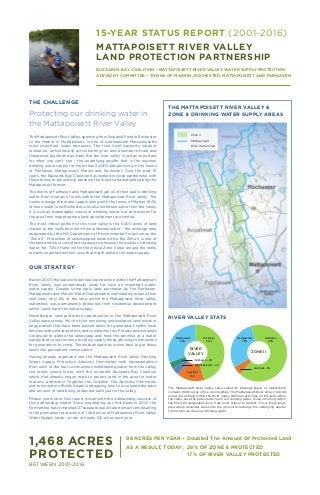
  • 1. 15-YEAR STATUS REPORT (2001-2016) MATTAPOISETT RIVER VALLEY LAND PROTECTION PARTNERSHIP BUZZARDS BAY COALITION • MATTAPOISETT RIVER VALLEY WATER SUPPLY PROTECTION ADVISORY COMMITTEE • TOWNS OF MARION, ROCHESTER, MATTAPOISETT AND FAIRHAVEN THE CHALLENGE Protecting our drinking water in the Mattapoisett River Valley The Mattapoisett River Valley, spanning from Snipatuit Pond in Rochester to the Harbor in Mattapoisett, is one of southeastern Massachusetts most important water resources. The river itself supports outdoor recreation, an historically active herring run and a number of rare and threatened plants and animals. But the river valley is just as important for what you can’t see – the underlying aquifer that is the regional drinking water supply for more than 24,000 people living in the towns of Fairhaven, Mattapoisett, Marion and Rochester. Over the past 15 years, the Buzzards Bay Coalition has worked in close partnership with these towns to proactively preserve the forests and wetlands along the Mattapoisett forever. The towns of Fairhaven and Mattapoisett get all of their public drinking water from a series of wells within the Mattapoisett River Valley. The towns manage this water supply along with the towns of Marion (60% of town water) and Rochester who also withdraw water from the valley. It is a clean, dependable source of drinking water, but protections for the area from inappropriate land development are limited. The most critical portion of this river valley is the 6,000 acres of land closest to the wells from which we withdraw water – the recharge area designated by the MA Department of Environmental Protection as the “Zone II”. Protection of undeveloped lands within the Zone II is one of the best and most cost effective ways to preserve the quality of drinking water. Yet, 72% of land within the critical Zone II area around the wells, remains unprotected from uses that might pollute the water supply. OUR STRATEGY Backin2000,thestatusofopenspaceprotectionwithintheMattapoisett River Valley was exceptionally weak for such an important public water supply. Despite some early land purchases by the Fairhaven, Mattapoisett and Marion Water Departments immediately around their well sites, only 8% of the land within the Mattapoisett River Valley watershed was permanently protected from residential development which could harm the water supply. Nevertheless, land protection opportunities in the Mattapoisett River Valley were strong. Much of the remaining undeveloped land exists in large parcels that have been passed down for generations within local families with solid land ethics and community ties. Forests and wetlands continued to define the landscape and held the promise of a water supply that could continue to safely supply these growing communities for generations to come. The work ahead was in how best to get these lands into permanent conservation. Having already organized into the Mattapoisett River Valley Drinking Water Supply Protection Advisory Committee with representatives from each of the four communities withdrawing water from the valley, the towns joined forces with the nonprofit Buzzards Bay Coalition which had already begun work to protect land in the area for water resource protection. Together the Coalition, the Advisory Committee and town water officials began strategizing how to accelerate the pace and amount of land being protected each year in the valley. Fifteen years later, this report documents the outstanding success of this partnership model. Since negotiating our first deals in 2001, the Partnership has completed 27 separate real estate transactions resulting in the permanent protection of 1,468 acres of Mattapoisett River Valley Water Supply lands – a rate of nearly 100 acres each year. THE MATTAPOISETT RIVER VALLEY & ZONE II DRINKING WATER SUPPLY AREAS 1,468 ACRES PROTECTED Zone II Mattapoisett River Watershed BETWEEN 2001-2016 98 ACRES PER YEAR – Doubled The Amount Of Protected Land AS A RESULT, TODAY: 28% OF ZONE II PROTECTED 17% OF RIVER VALLEY PROTECTED RIVER VALLEY RIVER VALLEY STATS ZONE II Mattapoisett 30% The Mattapoisett River Valley (also called its Drainage Basin or Watershed) contains 18,381 acres in five communities. The Mattapoisett River Zone II (6,000 acres) lies entirely within the River Valley. While all activities on the land within the valley have the potential to harm our drinking water, those occurring within the MA DEP-designated Zone II are most critical to protect. This is the primary area where rainwater soaks into the ground to recharge the underlying aquifer from which we draw our drinking water. Rochester 46% Acushnet 16% Fairhaven – 4% Middleborough – 4% Mattapoisett 29% Rochester 66% Acushnet – 5%
  • 2. Beyond the planning and fundraising, the day-to-day work of the Mattapoisett River Valley Land Protection Partnership has been with the landowners and families of this landscape – many of whom have owned these lands for generations. The maps on the following pages show how these deals unfolded between 2001-2016. Behind the labels and colors on the map are many of the foundation families of Old Rochester – the Rounsevilles, Churches, and Tinkhams – and relative newcomers like the Decas, McIntryre, and Keeler families. It has been our privilege to work with all of them to preserve not only the waters but the rural character and beauty of the Mattapoisett River Valley. Between 2001-2016, the Mattapoisett River Valley Land Protection Partnership completed 27 separate real estate transactions with landowners willing to sell or donate their land for conservation. All participation by landowners was entirely voluntary. In selecting deals to pursue, land immediately adjacent to wells was considered a priority for outright acquisition to allow for the highest level of protection of the water supply. Adjacent lands were considered suitable for protection through Conservation Restricitions (CR). A CR is a permanent agreement between a conservation nonprofit like the Buzzards Bay Coalition or a town conservation commission or water department which prevents development of land while allowing it to remain in private ownership. The Mattapoisett River Valley straddles five communities – Mattapoisett, Rochester, Fairhaven, Acushnet and Middleborough – but the vast majority of the Valley and its critical Zone II lies in Rochester and Mattapoisett. Therefore, the lands protected over the past fifteen years have mirrored this distribution. As a regional water resource, what town boundary a parcel of land might fall within matters much less than how that land contributes to the overall protection of the water supply. As a result, many deals saw voters in Marion, Mattapoisett and Fairhaven voting to spend their own town funds on lands in other communities – a testament to the strength of this truly regional water supply. THE RESULTS Between 2001-2016, the Mattapoisett River Valley Land Protection Partnership permanently protected 1,468 acres of land to maintain the quality and quantity of our region’s drinking water supply. Four charts tell the story best. Funding to acquire the lands and Conservation Restrictions featured in this 15-year report was split nearly equally between government grant (53%) and private (47%) sources. The largest source of support came from generous local landowners who agreed to sell their land for less than its Fair Market Value in order to see the land protected. These ‘bargain sales’ of land totaled $5,338,000 in donated value. The Buzzards Bay Coalition also raised $787,687 in gifts from individuals, families and foundations concerned about clean water. On the government side, funding was divided almost equally between local, state and federal sources. Town funding primarily came in the form of contributions from the Mattapoisett River “Water Supply Protection Fund” which collects approximately $75,000 each year as a user fee of one penny per one hundred gallons used. Since 2010, these local funds have been supplemented with Community Preservation Funds in the towns of Fairhaven, Mattapoisett and Marion. The Buzzards Bay Coalition coordinated State and Federal Grant applications, usually in close partnership with a municipal applicant. Most notable among these programs were MA DEP Drinking Water Supply Protection Grants and the US Department of Agriculture’s Wetland Reserve Program. In selecting lands for protection, first priority was placed on properties within the Zone II Recharge Area for the Mattapoisett River Valley municipal wells system. These areas have been determined to most directly recharge the groundwater around the wells so their protection is most important to maintaining both water quality and quantity. Second priority was granted to forest and wetlands. These areas are powerful pollution filters, help maintain soil and water temperatures, reduce stormwater runoff and encourage groundwater recharge, and provide wildlife habitat. The cranberry bogs acquired are immediately adjacent to two important wells and were removed from cultivation in order to prevent potential pollution from fertilizers, pesticides and herbicides and restore natural water flows both of which further support the maintenance of healthy drinking water. THE DEALS $13M MA State Grants $1,890,200 15% Federal Grants $2,880,513 22% Town Funding $2,019,257 16% Private Funds $787,687 6% Landowner Bargains Sales & Gifts of Land $5,338,200 41% 1,468 acres Freshwater Wetland 597 acres 41% Upland Forest 789 acres 54% Cranberry Bog – 53 acres – 4% Agricultural Fields – 4 acres – 0% Non-Farm Open Land – 20 acres – 1% 27 Deals Outright Fee Acquisition 898 acres 61% Conservation Restrictions 571 acres 39% 4 Towns Rochester 768 acres 52% Mattapoisett 598 acres 41% Fairhaven – 67 acres – 5% Acushnet – 35 acres – 2% Beyond the planning and fundraising, the day-to-day work of the Mattapoisett River Valley Land Protection Partnership has been with the landowners and families of this landscape – many of whom have owned these lands for generations. The maps on the following pages show how these deals unfolded between 2001-2016. Behind the labels and colors on the map are many of the foundation families of Old Rochester – the Rounsevilles, Churches, and Tinkhams – and relative “newcomers” like the Decas Cranberry Company, and the McIntire and Keeler families. It has been our privilege to work with all of them to preserve not only the waters but the rural character and beauty of the Mattapoisett River Valley. THE DEALS
  • 3. ^ ^^ Mattapoisett Harbor Snipatuit Pond ROCHESTER MATTAPOISETT MIDDLEBOROUGH ROCHESTER ROCHESTER ACUSHNET MATTAPOISETT FAIRHAVEN MATTAPOISETT ACUSHNET 15-YEAR STATUS REPORT (2001-2016) MATTAPOISETT RIVER VALLEY LAND PROTECTION PARTNERSHIP BUZZARDS BAY COALITION & MATTAPOISETT RIVER VALLEY WATER SUPPLY PROTECTION ADVISORY COMMITTEE2001 2001BaselineYear DEP-Approved Public Water Suppy Wells Mattapoisett River Valley Watershed Municipal Boundaries DEP Core Wetland Resources Existing Protected Lands DEP Drinking Water Zone II Assessors’ Parcels DEP-Approved Public Water Supply Wells Mattapoisett River Valley Watershed Municipal Boundaries DEP Core Wetland Resources Existing Protected Lands DEP Drinking Water Zone II Assessors' Parcels 0 1 20.5 Miles Data Sources: MassGIS &Buzzards Bay NEP DEP-Approved Public Water Supply Wells Mattapoisett River Valley Watershed Municipal Boundaries DEP Core Wetland Resources Existing Protected Lands DEP Drinking Water Zone II Assessors' Parcels 0 1 20.5 Miles Data Sources: MassGIS &Buzzards Bay NEP Data Sources: MassGIS & Buzzards Bay National Estuary Program
  • 4. Snipatuit Pond ROCHESTER MATTAPOISETT MIDDLEBOROUGH ROCHESTER ROCHESTER ACUSHNET MATTAPOISETT FAIRHAVEN MATTAPOISETT ACUSHNET Rounseville North (Phase II) 2005 164 acres Rounseville South (Phase I) 2002 241 acres Church 2005 163 acres Tinkham Lands 2006 75 acres Willoughby 2002 16 acresTinkham Lands 2005 35 acres DEP-Approved Public Water Suppy Wells Mattapoisett River Valley Watershed Municipal Boundaries BBC Partnership Projects DEP Core Wetland Resources Existing Protected Lands DEP Drinking Water Zone II Assessors’ Parcels 15-YEAR STATUS REPORT (2001-2016) MATTAPOISETT RIVER VALLEY LAND PROTECTION PARTNERSHIP BUZZARDS BAY COALITION & MATTAPOISETT RIVER VALLEY WATER SUPPLY PROTECTION ADVISORY COMMITTEE2006 Rounseville North (Phase II) 2005 164 acres Rounseville South (Phase I) 2002 241 acres Church 2005 163 acres Tinkham Lands 2006 75 acres Willoughby 2002 16 acresTinkham Lands 2005 35 acres DEP-Approved Public Water Supply Wells Mattapoisett River Valley Watershed Municipal Boundaries DEP Core Wetland Resources Existing Protected Lands DEP Drinking Water Zone II Assessors' Parcels 0 1 20.5 Miles Data Sources: MassGIS &Buzzards Bay NEP DEP-Approved Public Water Supply Wells Mattapoisett River Valley Watershed Municipal Boundaries DEP Core Wetland Resources Existing Protected Lands DEP Drinking Water Zone II Assessors' Parcels 0 1 20.5 Miles Data Sources: MassGIS &Buzzards Bay NEP Data Sources: MassGIS & Buzzards Bay National Estuary Program
  • 5. DEP-Approved Public Water Suppy Wells Mattapoisett River Valley Watershed Municipal Boundaries BBC Partnership Projects DEP Core Wetland Resources Existing Protected Lands DEP Drinking Water Zone II Assessors’ Parcels 15-YEAR STATUS REPORT (2001-2016) MATTAPOISETT RIVER VALLEY LAND PROTECTION PARTNERSHIP BUZZARDS BAY COALITION & MATTAPOISETT RIVER VALLEY WATER SUPPLY PROTECTION ADVISORY COMMITTEE2011 Mattapoisett Harbor Snipatuit Pond ROCHESTER MATTAPOISETT MIDDLEBOROUGH ROCHESTER ROCHESTER ACUSHNET MATTAPOISETT FAIRHAVEN MATTAPOISETT ACUSHNET Gaumont 2007 7 acres Red Barn Farm (Keeler) 2007 60 acres MacPhail 2009 12.5 acres Rounseville 2009 30 acres Gurney 2009 17 acres Fitzgerald 2009 8 acres Mahoney Wells 2010 20 acres Church Mattapoisett Road 2010 32 acres Rentumis 2011 54.2 acres Mahoney Wolf Island Road 2011 18 acresMahoney New Boston Road 2011 0.31 acre Mahoney New Boston Road 2011 59 acres Mahoney Wolf Island Road 2011 10 acres Dufficy-Lawrence 2011 7.5 acres Decas Tripp Mill 2011 42.67 acres Decas Bogs 2011 125 acres Mahoney Brook Parcel 2010 24 acres DEP-Approved Public Water Supply Wells Mattapoisett River Valley Watershed Municipal Boundaries DEP Core Wetland Resources Existing Protected Lands DEP Drinking Water Zone II Assessors' Parcels 0 1 20.5 Miles Data Sources: MassGIS &Buzzards Bay NEP DEP-Approved Public Water Supply Wells Mattapoisett River Valley Watershed Municipal Boundaries DEP Core Wetland Resources Existing Protected Lands DEP Drinking Water Zone II Assessors' Parcels 0 1 20.5 Miles Data Sources: MassGIS &Buzzards Bay NEP Data Sources: MassGIS & Buzzards Bay National Estuary Program
  • 6. Mattapoisett Harbor Snipatuit Pond ROCHESTER MATTAPOISETT MIDDLEBOROUGH ROCHESTER ROCHESTER ACUSHNET MATTAPOISETT FAIRHAVEN MATTAPOISETT ACUSHNET Mattapoisett Riverfront 2015 16.5 acres Mahoney Town Line 2012 63 acres North Woods 2013 33 acres Tinkham Woodlands 2016 47.7 acres Tinkham Woodlands 2016 86.94 acres Roy-Hawkes Under Agreement 164 acres DEP-Approved Public Water Supply Wells Mattapoisett River Valley Watershed Municipal Boundaries DEP Core Wetland Resources Existing Protected Lands DEP Drinking Water Zone II Assessors' Parcels 0 1 20.5 Miles Data Sources: MassGIS &Buzzards Bay NEP DEP-Approved Public Water Supply Wells Mattapoisett River Valley Watershed Municipal Boundaries DEP Core Wetland Resources Existing Protected Lands DEP Drinking Water Zone II Assessors' Parcels 0 1 20.5 Miles Data Sources: MassGIS &Buzzards Bay NEPDEP-Approved Public Water Suppy Wells Mattapoisett River Valley Watershed Municipal Boundaries BBC Partnership Projects DEP Core Wetland Resources Existing Protected Lands DEP Drinking Water Zone II Assessors’ Parcels Data Sources: MassGIS & Buzzards Bay National Estuary Program 15-YEAR STATUS REPORT (2001-2016) MATTAPOISETT RIVER VALLEY LAND PROTECTION PARTNERSHIP BUZZARDS BAY COALITION & MATTAPOISETT RIVER VALLEY WATER SUPPLY PROTECTION ADVISORY COMMITTEE2016 Mattapoisett Riverfront 2015 16.5 acres Mahoney Town Line 2012 63 acres North Woods 2013 33 acres Tinkham Woodlands 2016 47.7 acres Tinkham Woodlands 2016 86.94 acres Roy-Hawkes Under Agreement 164 acres
  • 7. THE PROJECTS Depending on the characteristics of the land, wishes of landowners, and available funding sources, each deal resulted in slightly different land protection outcomes. Lands destined for walking trail networks, hunting and fishing, and canoe access were prioritized for ownership by the Buzzards Bay Coalition who committed to manage the land for responsible public use into the future. Lands close to wells were acquired by town Water Departments, and private lands were protected with Conservation Restrictions (CRs). This flexible approach to each individual deal has been one of the hallmarks of this partnership and will continue in the years ahead. What is common to every transaction, however, is that the land is protected from development forever – usually through multiple reinforcing land ownership and CR agreements. THE BENEFITS Protecting Water Quality The forests and wetlands of Mattapoisett River Valley work together to shield the river and the valley aquifer from excess nitrogen and other pollutants. When development and urbanization threaten the natural spaces that filter out pollutants and prevent them from entering the water supply, the overall quality of the water in the valley can be degraded. This manifests through an increase in contaminantsenteringthewatershed,whichcanincludewastewater from residential septic systems, pesticides and fertilizers from lawns and gardens, road salts, and heavy metals. Permanent protection of this land sustains the essential natural areas that protect against contamination, safeguarding clean drinking water for more than 24,000 people and ensuring that the Mattapoisett River Valley drinking water supply will remain healthy for generations to come.  Maintaining Water Quantity In the Mattapoisett River Valley, the aquifer is maintained as water soaks into the ground after rainfall. The area in which this occurs is known as the recharge area, or Zone II (See map on page 1). However, 72% of land in Zone II is not currently protected from development, which threatens the pervious surfaces that allow water to soak into the ground in the recharge area. Housing developments, driveways and roads are all examples of impervious surfaces resulting from development that decrease the base flow reaching the aquifer. Protecting land around the Mattapoisett River Valley recharge area safeguards against the construction of impervious surfaces, ensuring that the base flow sustaining the aquifer will be protected and that there will be an adequate supply of clean water for all. Expanding Outdoor Recreation Protecting land in the Mattapoisett River Valley does more than safeguard against ecological threats—it also provides additional recreational spaces and opportunities for local residents. On much of the land that has been protected in the valley, the public is welcome to explore the preserved areas and engage in passive recreation opportunities. Depending on the site, visitors can enjoy miles of walking trails, fish, birdwatch, cross-country ski, hunt, and more. Preserving land around the Mattapoisett River Valley affords residents the chance to get outdoors and enjoy the natural beauty of the South Coast—just steps from their homes, offices, and schools. It also ensures that their children and grandchildren will be able to experience the unspoiled magnificence of the area. Preserving Fish and Wildlife Preserving open space also benefits the animals and plants that call the Mattapoisett River Valley home. Much is at stake—the Mattapoisett River has historically been home to one of the largest herring populations on Buzzards Bay with thousands of herring migrating up the river to spawn each year. Other species, such as shad, sturgeon, and Atlantic salmon are entirely gone from the region.Onland,thevalleyishometoanumberofrareandthreatened species of plants and animals with much of the area mapped by the state as Priority Habitat. Therefore, it is imperative to preserve large, contiguous areas of open space in the Mattapoisett River Valley to protect the well-being of keystone species threatened by habitat degradation and fragmentation.  YEAR PROJECT NAME TOWN TOTAL ACRES LAND PROTECTION OUTCOME OWNERSHIP CONSERVATION RESTRICTION HOLDER(S) 2002 Willoughby Mattapoisett 16 Mattapoisett Conservation Commission 2002 Rounseville Homestead South Rochester 241 Private Rochester Land Trust & Marion Water Department 2005 Tinkham Pond lands Acushnet 35 Fairhaven-Acushnet Land Preservation Trust 2005 Rounseville Homestead North Rochester 164 Private Wildlands Trust & Rochester Conservation Commission 2005 Church Homestead Rochester 163 MA Division of Fish & Game 2006 Tinkham Lands Mattapoisett 75 Mattapoisett Water Department 2007 Gaumont Farm Rochester 7 Private Buzzards Bay Coaltion & Rochester Land Trust 2007 Red Barn Farm Rochester 60 Private Buzzards Bay Coaltion & Rochester Land Trust 2009 Fitzgerald Fairhaven 8 Fairhaven Conservation Commission Buzzards Bay Coaltion 2009 Rounseville woodlot Mattapoisett 30 Mattapoisett Water Department 2009 MacPhail Rochester 12.5 Private Buzzards Bay Coaltion & Rochester Land Trust 2009 Gurney Rochester/Mattapoisett 17 Private Buzzards Bay Coaltion & Rochester Land Trust 2010 Mahoney Brook Parcel Mattapoisett 24 Buzzards Bay Coalition Mattapoisett Conservation Commission CR 2010 Mahoney Wells Mattapoisett 20 Mattapoisett Water Department 2010 Church Mattapoisett Road Rochester 32 Rochester Land Trust 2011 Mahoney New Boston Road Acushnet 0.31 Buzzards Bay Coalition 2011 Mahoney New Boston Road Fairhaven 59 Fairhaven Conservation Commission Buzzards Bay Coalition 2011 Mahoney Wolf Island Road Mattapoisett 18 Mattapoisett Water Department Fairhaven Water Department 2011 Decas Tripps Mill Mattapoisett 42.67 Mattapoisett Conservation Commission Buzzards Bay Coalition 2011 Decas Bogs Mattapoisett 125 Buzzards Bay Coalition USDA Natural Resources Conservation Service 2011 Rentumis Rochester 54.2 Marion Water Department Buzzards Bay Coalition 2011 Mahoney Wolf Island Road Rochester 10 Rochester Conservation Commission Fairhaven Water Department 2011 Dufficy-Lawrence Rochester 7.5 Private Buzzards Bay Coaltion & Rochester Land Trust 2012 Town Line Lots Mattapoisett 63 Buzzards Bay Coalition Mattapoisett Conservation Commission 2013 North Woods Mattapoisett 33 Mattapoisett Conservation Commission Buzzards Bay Coalition 2015 Mattapoisett Riverfront Mattapoisett 16.6 Mattapoisett Conservation Commission Buzzards Bay Coalition 2016 Tinkhamtown Woodlands I Mattapoisett 115.3 Mattapoisett Water Department Buzzards Bay Coalition, Fairhaven Water and Marion Water Depts 2016 Tinkhamtown Woodlands II Mattapoisett 19.3 Buzzards Bay Coalition 1,468
  • 8. In Closing, In the past fifteen years, the Buzzards Bay Coalition, working in close partnership with the Mattapoisett River Valley Water Supply Protection Advisory Committee, has made extraordinary progress toward the permanent protection of our drinking water. 1,468 acres of land were preserved around our wells between 2001-2016. The model created for this work leveraged local government funding for drinking water supply protection by six times, making it possible to protect land in the Mattapoisett River Valley at a rate of nearly 100 acres per year. This critical work continues today with much more land in need of protection around our wells. 114 Front St. New Bedford, MA 02740 (508) 999-6363 | www.savebuzzardsbay.org Dedicated to the restoration, protection and sustainable use and enjoyment of our irreplaceable Bay and its watershed. P.O. Box 1055 | Mattapoisett, MA 02739 | www.mrvwspac.org Managing Water Resources For Our Future and Protecting the Aquifer for Fairhaven, Marion, Mattapoisett & Rochester PHOTOS: THIS PAGE – TIM SYLVIA, FRONT – SIPPICAN WEEK