SlideShare a Scribd company logo
1 of 12
Download to read offline
Delhi Sultanate Waterworks
Ancient network of water harvesting
structures in Delhi, India.
Tanvi Gupta
Figure 1 Typical Baoli stepwell atmosphere.
Delhi Sultanate
Waterworks
Y
a
m
u
n
a
Y
a
m
u
n
a
Najafgarh canal
New Delhi
Hauz Khas
Chha�arpur
IGI Airport
Badarpur
Dwarka
Rohini
Shalimar Bagh
Shahdara
Narela
Bawana
Mukandpur
Palla
Asola
Northern Basin
Southern Basin
Western Basin
Delhi is located in the Northern part of India between
28.7041 N latitudes and 77.1025 E longitude. It occupies
an area of 1,484 sq. km. and is continuously inhabited since
the 6th century BCE. Through most of its history Delhi has
served as capital of various kingdoms, most notably the
Delhi Sultanate and Maughal empire.
Two prominent features of the geography of Delhi are the
Yamuna floodplains and the Delhi ridge. The ridge is the
northern extension of the ancient Aravalli range covering an
area of about 35 km and reaching height of 318 m (1,043 ft),
it is a dominant feature of the region.
Figure 2 Country scale map
Water-shed Yamuna
Region of Delhi
Southern basin,
Catchment area
Figure 3
City scale map: the traditional water system of the bund baoli and hauz start-
ing from the Delhi sultanate is chosen for study.
Context.
Delhi Sultanate Waterworks
Delhi’s urban waterworks developed in early thirteenth
century. They took the following main forms of Hauz (water
tank), baoli (stepwell) and bund (embankment). Collectively
these small structures served the sultanate capitals of
South Western Delhi. As with other ancient and medieval
water systems, they were incremental and coordinated.
Urban lakes, tanks and reservoirs were sited in gently sloping
areas adjacent to hillside water control structures.
Sultanate Waterworks.
Figure 4 Historical photo of Satpulla embankment or bund.
Figure 5 Historical photo of Baoli at Tughlaqabad.
Figure 6 Historical photo of Hauz-i-khas lake (water tank).
Figure 7 Historical photo of Sluice gate at Tughlaqabad.
Delhi Sultanate Waterworks
Jan Feb Mar Apr May Jun Jul Aug Sep Oct Nov Dec
0
19 19 15
20 25
70
237.5 235
112
18
10 10
5
10
15
20
25
30
35
40
45
t ( C)
high t
low t
Climate.
Figure 8 Temperature and precipitation graph. Figure 9 Evapotranspiration map Figure 10 Annual Precipitation map
Delhi Sultanate Waterworks
The contours of the physical landscape of Delhi as we see
today, including its flora and fauna are very different from
what they were thousands of years ago. The Delhi ridge as
shown in the figure constitute the Northernmost extensions
of the Aravalli hills, the oldest mountains in India formed
hundreds of million years ago. They enter Delhi from the
South-West running through the city in a North-east
direction. Today the height of the rocky Delhi ridge ranges
between 2.5 m to 90 m above floodplain in North and South
Delhi, in ancient times it would have been much higher (S.
Upinder, 2006).
Most Sultanate cities and waterworks aligned themselves
along this ridge to capture its runoff. The junction between
the central and the Southern ridge became the preferred
location for Sultanate urbanization and water control. Delhi
sultanate waterworks developed during the early 13th
century. They took three main forms - the bund network
(embankment), hauz (water tank), and baoli (stepwell). These
reflect the main strategies of the Delhi Sultanate water
works - the bund network helps in directing and capturing
the runoff from the ridge, the hauz stores the surplus
monsoon surface water runoff and recharges ground water
while the baolis tap into the shallow ground water along with
storing rainwater.
The bunds define a network of 25 water structures along 40
miles of the ridge as shown in the figure. They harnessed
rain fed rivulets or sheet drainage along the slopes of Delhi
ridge to create perennial reservoirs, for use in the dry winter
months.
Thus, the first bund sequence on either side of the ridge
entrapped rain runoff and the second sequence controlled
and channeled water to city reservoirs, defense moats and
irrigation canals. This 40 mile network with over 15 rivulets
and 60 miles of running water was in continuous use for
over two centuries.
Delhi’s Streams or Nallahs
In the triangle created or the ridge, Delhi’s alluvial plain
is watered by a number of seasonal or perennial nallahs
(canals). These nallahs flow down the Aravalli hills (ridge)
slope through eroded gullies into the Yamuna river.
East flowing streams were tapped to feed large, lined lakes
such as Anangtal, Hauz-i-Shamsi, Hauz-i-rani, and hauz-
i-khas which sustained the cities of Anangpur, Mehrauli,
Jahanpanah and Siri. Despite the presence of river Yamuna
most of Delhi’s population depended on underground or
stored water until the arrival of piped water supply in the
late nineteenth century. Water tables recharged by nallahs
allowed a number of baolis (large stepwells built with several
levels).
The quality of groundwater shows wide variations with depth,
at most locations water quality deteriorates with depth.
Canals and streams play an important role in sustaining
fresh water aquifers in Delhi’s upper strata of water-bearing
soil.
Catchment Area.
Figure 11 Bund network along Ridge.
Delhi Sultanate Waterworks
Tughlaqabad Fort Water system.
During the period of Delhi Sultanate, new cities were founded
at strategic locations where water was the most important
factor in their siting - its collection, storage and distribution
predominated the settlement pattern. Tughlaqabad fort was
built by Ghiyas-ud-din Tughlaq, located on a hill surrounded
by a basin.
The fort was planned based on the contours of the site to
form an irregular trapezium. The palace was quarried from
the site itself and the quarries were subsequently used as
moats and reservoirs. The surroundings of Tughlaqabad was
transformed into a large lake with the help of waterworks
(bunds) which collected water from the ridge. Tughlaqabad
had 3 huge baolis and several wells for water supply as
highlighted in the illustration.
Creating a lake at the South of the Tughlaqabad fort was a
challenge since the site was not close to river Yamuna and
in order to bring the river water up to the hilltop where the
fort was located, water had to be pumped up by means
of a canal which was considered impractical. The lake
was therefore dependent on local streams and monsoon
floodwater which was channeled into a depression at
the south of the town where the water was regulated by
means of several dams and a sluice gate controlling the
outlet which flowed into a canal. The dams are constructed
as simple earth embankments lined on the lake side with
blocks of stone. This stretch is around 200m long and runs
between Adilabad and Tughlaqabad.
Stepwells, water channels, embankments and canals.
Figure 12 View of Southern end of retaining wall of the dam between Adila-
bad and Tughlaqabad seen from lakeside showing steps leading to water.
Figure 13 View of Tughlaqabad lake surrounding tomb of Ghiyas-ud-din Tugh-
laq.
Figure 14 Tughlaqabad town water system plan.
Delhi Sultanate Waterworks
A main water feature in the Tughlaqabad fort is a deep
stepped reservoir (baoli). The baoli is roughly rectangular
about 20 x 18 m. Towards the east side we see the remains
of the steps which gave access to the water, the baoli is
approximately over 16m deep. Towards the North we see the
stone brackets for wheel or pulley are preserved, extending
over the water. This apparatus was used for withdrawing
large quantities of water for irrigation and it is likely that
this baoli was a major source of water for farmlands, while
drinking water was provided elsewhere.
It was a usual practice during this period to construct forts
on rocky hillsides to excavate wells down to the water table
to ensure permanent supply of potable water.
Stepwells, water channels and embankments.
Tughlaqabad Fort Baoli.
Figure 15 Baoli typology analysis and details. Key plan (above).
Delhi Sultanate Waterworks
Another example of the ingenious water structure is the
sluice gate, controlling the level of water in the lake water
south of the town of Tughlaqabad. The water work was a
simple device which could be operated by an unskilled
person - an uncomplicated structure with a sophisticated
design.
The structure opens to a canal with stone lined walls which
runs between the dam and the outer fortification walls of
Adilabad. The canal was further divided into two branches,
one taking the water to the irrigated fields and the other
leading to moat around town wall.
The sluice gate itself consists of three arches, each
containing twelve small sluices at four levels, three sluices
at each level. The western side of the arch facing the lake is
walled up with massive stones and the inlet of the sluices are
small rectangular canals, which appear as small apertures
on lake side. Inside the arches, the four levels of sluices
are stacked in a step form with eight steps. The lower step
is for standing on and the upper one has the slots. Each
slot measured 35x10 cm wide and 75 cm deep to house
wooden shutters which controlled the flow of water. Access
to these steps is provided via two sets of stairs built into the
piers at either end of the structure.
Tughlaqabad Fort bund.
Stepwells, water channels and embankments.
Figure 16 The sluice gate and Dam south of Tughlaqabad.
Figure 17 Sluice gate site plan.
Figure 18 Sluice gate plan.
Figure 19 Sluice gate plan at roof level.
Figure 20 Sluice gate view from lake looking Eastwards.
Figure 21 Sluice gate elevation lake side looking eastwards.
Delhi Sultanate Waterworks
Functioning
The operation of the sluice gate was simple and could be
carried out by a single person, who first went down to the
lowest level to insert small shutters into slots of the lowest
nine canals. The water of the lake would then rise up to
the next level and the same process would be repeated at
this level. In the case of heavy monsoon, a single person
would remove the shutter of the upper level and excess
water would gush out as small waterfall through the arches
into the canal.
The site of the lake is now used for cultivation. The design
concept of this sluice gate, to retain and control the water
of a relatively large lake by a very simple method and no use
of power was a great achievement of its time.
Figure 22 Sluice gate elevation dam side looking westwards
Figure 23 Sluice gate plan
Figure 24 Detail plan of central slots
Figure 25 Section AA through central arch showing four levels of sluices and
highest water level
Figure 26 Perspective section showing sluice functioning
Figure 27 Showing function of sluice with help of wooden shutter
Figure 28 Wooden shutter detail
Delhi Sultanate Waterworks
Circularity.
Delhi Sultanate waterworks or harvesting structures were
well coordinated with one another, each structure supporting
the existence of the other. The bunds helped in controlling
the rainwater runoff from the ridge which was further
directed to feed large lakes or royal tanks called hauz. The
baoli were recharged by the rainwater and helped in tapping
the inaccessible ground water with the help of steps. These
water storage structures aided water evaporation and
condensation into the atmosphere which again would be
captured in the ridge landscape during monsoon.
Today, these water structures lie in a dilapidated state
with some having been restored for heritage and tourism
purposes. Thus, it is important to learn from past methods
of harvesting water to overcome the hydrological problems
Delhi is facing today, despite having a combination of river
and ridge landscape as part of its natural terrain.
Circularity
Delhi Sutanate waterworks or harvesting structures were well coordinated
with one another, each structure supporting the existence of the other. The
bunds helped in controlling the rainwater runoff from the ridge which was
further directed to feed large lakes or royal tanks called hauz. The baoli
were recharged by the rainwater and helped in tapping the inaccessible
ground water with the help of steps. These water storage structures aided
water evaporation and condensation into the atmosphere which again
would be captured in the ridge landscape during monsoon.
Today, these water structures lie in a dilapidated state with some having
been restored for heritage and tourism purposes. Thus, it is important to
learn from past methods of harvesting water to overcome the hydrological
problems Delhi is facing today, despite having a combination of river and
ridge landscape as part of its natural terrain.
Figure Circularity of the system
Figure 29 Circularity of the system.
Delhi Sultanate Waterworks
Strategic values - During this period Delhi’s terrain was used
smartly to gain maximum profit with the minimum resources
by taking advantage of Delhi’s hilly ridge landscape where
most of the waterworks were situated. This landscape
provided all resources like maximum rain, groundwater in
order to harvest water efficiently without using any source
of energy or power.
Values of Sustainability - The project shows the
sustainability of the water system, the natural and human
resources have been carefully used such as taking
advantage of the natural flow of water from higher terrain to
lower. This water captured was used for both the purpose
of meeting the drinking water needs of Delhi and also
the irrigation needs for agriculture. These also served the
purpose of rainwater storage or rainwater harvesting. Most
of the elements performed more than double the function.
Ethnographic and Identity values - The Sultanate period
is known for its famous tank system (hauz), another very
important structure of water management the period is
known for its the network of stepwells or baolis. Most of
Sultanate waterworks were of secular character whereby
anyone could draw water from them and were mainly used
for common people’s water needs and requirements.
Landscape values - Water played an important role in the
location of most of Sultanate cities and settlements. This
whole system of tank, baolis and wells manages water
supply to whole complex of settlements during medieval
history period of Delhi. Moreover, the system was planned
to function as a decentralized runoff harvesting such that
silting of a tank at one location did not affect the others.
The homogeneity of the system avoided all post-harvesting
social problems of water management that are involved in
water management.
The purpose of this research is to study the ancient or
medieval water management system during the period of
Sultanate Delhi and their understanding of the region’s terrain
to harvest water through various water work structures.
The study focuses on the urban water management of
Sultanate Delhi, where most of the cities were located
on Delhi’s hilly ridge terrain from where rain water was
controlled and channelized. Being in a humid sub tropical
and semi arid zone, the frequency of water shortages and
droughts is high. However ‘Ancient civilizations grasped the
complex reciprocities of natural systems and created an
infrastructure that was modeled on, and worked in tandem
with those reciprocities’ (Brown and Stigge, 2017).
The Delhi watershed comprised of ridge,river and plains,
its constellation of channels, canals, bridges and tanks
served all important for conserving the city. Delhi
Sultanate waterworks influenced subsequent eras of urban
development and conservation.
The historical water works of Sultanate Delhi have urban-
scale significance. With efforts to recover the dying
wisdom of traditional water harvesting systems which
have expanding meaning and utility. Many of these urban
historical waterworks are at a risk of further deterioration
along with the degraded canals of the city. However, their
imposing architecture continue to persist in the city’s
landscape.
Architectural values - The structural elements and materials
used in the system came from the knowledge of traditional
or vernacular construction techniques which adapt to the
climate and lithology of the region. The smaller bunds or
embankments were constructed of Earth, however large
dams were built of rubble masonry or wood which were
easily available local materials.
Conclusion.
Lessons to learn - The study shows that Delhi was not
always short of water. It was ensured that Delhi had enough
water from its wells, baolis, water tanks, canals, ridge and
the Yamuna. The ancient rulers of Delhi had an intricately
worked out water conservation and distribution system
along the Southern ridge ,the tail end of the Aravalli hills.
They realized the importance of water security and made an
elaborate system of bunds across gullies to capture water
off this rocky landscape.
In present times, these water structures lie in a dilapidated
state, some have been restored to their past glory but only
for heritage purposes. Most of these sites have been taken
over by the powerful and the rich to make their houses
and other urban infrastructure, decimating the cities water
resources.
Today, most of the water needs of the citizens of Delhi are
met by exploiting its ground water resource by continuous
extraction of ground water through private tube-wells. If
these dilapidated water structures of Delhi are restored
and protected they can still contribute to some of the city’s
water requirements. Thus, it is important to learn how Delhi’s
historical rulers made use of its terrain of ridge and river
landscape to ensure supply of water to its citizens without
exploiting and wasting its resources.
Figure 30 Conserved baoli in Delhi, India
Delhi Sultanate Waterworks
Project 5 - Delhi Sultanate Waterworks
M. Shokoohy, N. Shokoohy, 2003 Tughluqabad, third interim
report: gates, silos, waterworks
and other features. Bulletin of the School of Oriental and Afri-
can Studies, 66, pp 14-55 doi:10.1017/S0041977X03000028
N. Jacob, 2008 Jalyatra: Exploring Indias Traditional Water
Management systems Retrieved from: http://www.jalyatra.
com/chapters/delhi_final.pdf
Delhi urban Art Commission, 2018 Water and Heriatage:
Rejuvenation of Baoli Precints Retrieved from: https://www.
duac.org/site_content/attachments/Water%20and%20Heri-
tage.pdf
D. Cherian, 2004 Pairing mega events and hydrological sys-
tems for urban sustainability: Strategy franework for Delhi
beyond the Commonwealth Games 2010. Retreived from:
https://dspace.mit.edu/handle/1721.1/28802
A. Sharma, M. Kumar, M. Singh, H. Mazhari 2019 Me-
dieval (Islamic) Cities in India: An Environmental Re-
view and its Contemporary Relevance https://doi.
org/10.1177/0376983619856166
Illustration Credits
Figure 1 [Image] Retrieved from https://www.
indiawaterportal.org/articles/sun-stone-and-water-rajon-ki-
baoli-mehrauli
Figure 2 Country scale map [Figure]. Drawn by author
Figure 3 City scale map [Figure]. Drawn by author
Figure 4 [image] Retrieved from https://www.jstor.org/
stable/44148473 DOI: 10.2307/44148473
Figure 5 [Image] Retrieved from https://
commons.m.wikimedia.org/wiki/File:Tuglagbad_Baoli_1.jpg
Figure 6 [Image] https://en.m.wikipedia.org/wiki/File:Hauz_
Khas_Lake.jpg
Figure 7 [Image] Retrieved from https://susycogamipybix.
hotseattleseahawksjerseys.com/tughluqabad-book-
35070zv.php
Figure 8 Temperature and precipitation graph [Figure].
Drawn by Author
Figure 9 Evapotranspiration map [Figure]. Drawn by Author
Figure 10 Annual Precipitation map [Figure]. Drawn by
Author
Figure 11 Bund Network along Ridge [Figure]. Drawn
by author. Retrieved from https://dspace.mit.edu/
handle/1721.1/28802
Figure 12 [Image] Retrieved from https://susycogamipybix.
hotseattleseahawksjerseys.com/tughluqabad-book-
35070zv.php
Figure 13 [Image] Retrieved from https://susycogamipybix.
hotseattleseahawksjerseys.com/tughluqabad-book-
35070zv.php
Figure 14 Tughlaqabad town watersystem plan
[Figure] Retrieved from https://susycogamipybix.
hotseattleseahawksjerseys.com/tughluqabad-book-
35070zv.php. Drawn by Author
Figure 15 Baoli typology analysis and details
[Figure] Retrieved from https://susycogamipybix.
hotseattleseahawksjerseys.com/tughluqabad-book-
35070zv.php. Drawn by Author
Figure 22 Sluice gate elevation dam side looking westwards.
[Image] Retrieved from https://susycogamipybix.hotseattle-
seahawksjerseys.com/tughluqabad-book-35070zv.php
Figure 23 Sluice gate plan [Figure] Retrieved from https://
susycogamipybix.hotseattleseahawksjerseys.com/tughluqa-
bad-book-35070zv.php. Drawn by Author
Figure 24 Detail plan of central slots [Figure] Retrieved from
https://susycogamipybix.hotseattleseahawksjerseys.com/
tughluqabad-book-35070zv.php. Drawn by Author
Figure 25 Section AA through central arch showing four lev-
els of sluices and highest water level [Figure] Retrieved from
https://susycogamipybix.hotseattleseahawksjerseys.com/
tughluqabad-book-35070zv.php. Drawn by Author
Figure 26 Perspective section showing sluice functioning
[Figure] Retrieved from https://susycogamipybix.hotseat-
tleseahawksjerseys.com/tughluqabad-book-35070zv.php.
Drawn by Author
Figure 27 Showing function of sluice with help of wooden
shutter [Figure] Retrieved from https://susycogamipybix.ho-
tseattleseahawksjerseys.com/tughluqabad-book-35070zv.
php. Drawn by Author
Figure 28 Wooden shutter detail [Figure] Retrieved from
https://susycogamipybix.hotseattleseahawksjerseys.com/
tughluqabad-book-35070zv.php. Drawn by Author
Figure 29 Circularity of the system [Figure] Drawn by Author
Figure 30 Conserved baoli in Delhi, India [Image] Retrieved
from https://archnet.org/sites/6400
References.
Delhi Sultanate Waterworks

More Related Content

Similar to Delhi-Sultanate-Waterworks_Tanvi-Gupta-1.pdf

Mullaperiyar dam voice of 3.5 million
Mullaperiyar dam voice of 3.5 millionMullaperiyar dam voice of 3.5 million
Mullaperiyar dam voice of 3.5 millionVimal Kumar
 
Water resourcs engineering
Water resourcs engineeringWater resourcs engineering
Water resourcs engineeringkajol panchal
 
3 sources of water supply
3 sources of water supply3 sources of water supply
3 sources of water supplyatul azad
 
Dholavira: a Harappan City
Dholavira: a Harappan CityDholavira: a Harappan City
Dholavira: a Harappan CityImon Ganguly
 
INDUS VALLEY CIVILISATION.pptx
INDUS VALLEY CIVILISATION.pptxINDUS VALLEY CIVILISATION.pptx
INDUS VALLEY CIVILISATION.pptxBhavaniUK
 
Ancient irrigation system
Ancient irrigation system Ancient irrigation system
Ancient irrigation system Supun Madushanka
 
Link canals, Baraages and Dams
Link canals, Baraages and DamsLink canals, Baraages and Dams
Link canals, Baraages and DamsRaees Shah
 
Dams and River (World Scenario)
Dams and River (World Scenario)Dams and River (World Scenario)
Dams and River (World Scenario)PradeepMeena51
 
Water resources. its depletion and its conservation
Water resources. its depletion and its conservationWater resources. its depletion and its conservation
Water resources. its depletion and its conservationMansi Rastogi
 
Paper 1 revision 29.5.13 bv
Paper 1 revision 29.5.13 bvPaper 1 revision 29.5.13 bv
Paper 1 revision 29.5.13 bvtudorgeog
 
FLOOD CONTINGENCY PLAN 2011 DISTRICT GOVT KASUR
FLOOD CONTINGENCY PLAN 2011 DISTRICT GOVT KASURFLOOD CONTINGENCY PLAN 2011 DISTRICT GOVT KASUR
FLOOD CONTINGENCY PLAN 2011 DISTRICT GOVT KASURHAFIZABDULHASEEB
 
FLOOD CONTINGENCY PLAN 2011 DISTRICT GOVT KASUR
FLOOD CONTINGENCY PLAN 2011 DISTRICT GOVT KASURFLOOD CONTINGENCY PLAN 2011 DISTRICT GOVT KASUR
FLOOD CONTINGENCY PLAN 2011 DISTRICT GOVT KASURHAFIZABDULHASEEB
 
Water resources
Water resourcesWater resources
Water resourcesUshaJoy
 

Similar to Delhi-Sultanate-Waterworks_Tanvi-Gupta-1.pdf (20)

Mullaperiyar dam voice of 3.5 million
Mullaperiyar dam voice of 3.5 millionMullaperiyar dam voice of 3.5 million
Mullaperiyar dam voice of 3.5 million
 
Water resourcs engineering
Water resourcs engineeringWater resourcs engineering
Water resourcs engineering
 
3 sources of water supply
3 sources of water supply3 sources of water supply
3 sources of water supply
 
Seville’s floods (Vicente González)
Seville’s floods (Vicente González)Seville’s floods (Vicente González)
Seville’s floods (Vicente González)
 
Dholavira: a Harappan City
Dholavira: a Harappan CityDholavira: a Harappan City
Dholavira: a Harappan City
 
INDUS VALLEY CIVILISATION.pptx
INDUS VALLEY CIVILISATION.pptxINDUS VALLEY CIVILISATION.pptx
INDUS VALLEY CIVILISATION.pptx
 
Krishna
KrishnaKrishna
Krishna
 
Ancient irrigation system
Ancient irrigation system Ancient irrigation system
Ancient irrigation system
 
Link canals, Baraages and Dams
Link canals, Baraages and DamsLink canals, Baraages and Dams
Link canals, Baraages and Dams
 
Dams and River (World Scenario)
Dams and River (World Scenario)Dams and River (World Scenario)
Dams and River (World Scenario)
 
Water resources. its depletion and its conservation
Water resources. its depletion and its conservationWater resources. its depletion and its conservation
Water resources. its depletion and its conservation
 
Paper 1 revision 29.5.13 bv
Paper 1 revision 29.5.13 bvPaper 1 revision 29.5.13 bv
Paper 1 revision 29.5.13 bv
 
FLOOD CONTINGENCY PLAN 2011
FLOOD CONTINGENCY PLAN 2011FLOOD CONTINGENCY PLAN 2011
FLOOD CONTINGENCY PLAN 2011
 
FLOOD CONTINGENCY PLAN 2011 DISTRICT GOVT KASUR
FLOOD CONTINGENCY PLAN 2011 DISTRICT GOVT KASURFLOOD CONTINGENCY PLAN 2011 DISTRICT GOVT KASUR
FLOOD CONTINGENCY PLAN 2011 DISTRICT GOVT KASUR
 
FLOOD CONTINGENCY PLAN 2011
FLOOD CONTINGENCY PLAN 2011FLOOD CONTINGENCY PLAN 2011
FLOOD CONTINGENCY PLAN 2011
 
FLOOD CONTINGENCY PLAN 2011 DISTRICT GOVT KASUR
FLOOD CONTINGENCY PLAN 2011 DISTRICT GOVT KASURFLOOD CONTINGENCY PLAN 2011 DISTRICT GOVT KASUR
FLOOD CONTINGENCY PLAN 2011 DISTRICT GOVT KASUR
 
Water resources
Water resourcesWater resources
Water resources
 
Geotech alignment of canal
Geotech alignment of canalGeotech alignment of canal
Geotech alignment of canal
 
Gt ppt
Gt pptGt ppt
Gt ppt
 
Dam
DamDam
Dam
 

Recently uploaded

Halmar dropshipping via API with DroFx
Halmar  dropshipping  via API with DroFxHalmar  dropshipping  via API with DroFx
Halmar dropshipping via API with DroFxolyaivanovalion
 
BigBuy dropshipping via API with DroFx.pptx
BigBuy dropshipping via API with DroFx.pptxBigBuy dropshipping via API with DroFx.pptx
BigBuy dropshipping via API with DroFx.pptxolyaivanovalion
 
Week-01-2.ppt BBB human Computer interaction
Week-01-2.ppt BBB human Computer interactionWeek-01-2.ppt BBB human Computer interaction
Week-01-2.ppt BBB human Computer interactionfulawalesam
 
(PARI) Call Girls Wanowrie ( 7001035870 ) HI-Fi Pune Escorts Service
(PARI) Call Girls Wanowrie ( 7001035870 ) HI-Fi Pune Escorts Service(PARI) Call Girls Wanowrie ( 7001035870 ) HI-Fi Pune Escorts Service
(PARI) Call Girls Wanowrie ( 7001035870 ) HI-Fi Pune Escorts Serviceranjana rawat
 
Customer Service Analytics - Make Sense of All Your Data.pptx
Customer Service Analytics - Make Sense of All Your Data.pptxCustomer Service Analytics - Make Sense of All Your Data.pptx
Customer Service Analytics - Make Sense of All Your Data.pptxEmmanuel Dauda
 
VIP High Profile Call Girls Amravati Aarushi 8250192130 Independent Escort Se...
VIP High Profile Call Girls Amravati Aarushi 8250192130 Independent Escort Se...VIP High Profile Call Girls Amravati Aarushi 8250192130 Independent Escort Se...
VIP High Profile Call Girls Amravati Aarushi 8250192130 Independent Escort Se...Suhani Kapoor
 
EMERCE - 2024 - AMSTERDAM - CROSS-PLATFORM TRACKING WITH GOOGLE ANALYTICS.pptx
EMERCE - 2024 - AMSTERDAM - CROSS-PLATFORM  TRACKING WITH GOOGLE ANALYTICS.pptxEMERCE - 2024 - AMSTERDAM - CROSS-PLATFORM  TRACKING WITH GOOGLE ANALYTICS.pptx
EMERCE - 2024 - AMSTERDAM - CROSS-PLATFORM TRACKING WITH GOOGLE ANALYTICS.pptxthyngster
 
Ukraine War presentation: KNOW THE BASICS
Ukraine War presentation: KNOW THE BASICSUkraine War presentation: KNOW THE BASICS
Ukraine War presentation: KNOW THE BASICSAishani27
 
VIP Call Girls Service Miyapur Hyderabad Call +91-8250192130
VIP Call Girls Service Miyapur Hyderabad Call +91-8250192130VIP Call Girls Service Miyapur Hyderabad Call +91-8250192130
VIP Call Girls Service Miyapur Hyderabad Call +91-8250192130Suhani Kapoor
 
Delhi Call Girls Punjabi Bagh 9711199171 ☎✔👌✔ Whatsapp Hard And Sexy Vip Call
Delhi Call Girls Punjabi Bagh 9711199171 ☎✔👌✔ Whatsapp Hard And Sexy Vip CallDelhi Call Girls Punjabi Bagh 9711199171 ☎✔👌✔ Whatsapp Hard And Sexy Vip Call
Delhi Call Girls Punjabi Bagh 9711199171 ☎✔👌✔ Whatsapp Hard And Sexy Vip Callshivangimorya083
 
Smarteg dropshipping via API with DroFx.pptx
Smarteg dropshipping via API with DroFx.pptxSmarteg dropshipping via API with DroFx.pptx
Smarteg dropshipping via API with DroFx.pptxolyaivanovalion
 
(ISHITA) Call Girls Service Hyderabad Call Now 8617697112 Hyderabad Escorts
(ISHITA) Call Girls Service Hyderabad Call Now 8617697112 Hyderabad Escorts(ISHITA) Call Girls Service Hyderabad Call Now 8617697112 Hyderabad Escorts
(ISHITA) Call Girls Service Hyderabad Call Now 8617697112 Hyderabad EscortsCall girls in Ahmedabad High profile
 
Industrialised data - the key to AI success.pdf
Industrialised data - the key to AI success.pdfIndustrialised data - the key to AI success.pdf
Industrialised data - the key to AI success.pdfLars Albertsson
 
Kantar AI Summit- Under Embargo till Wednesday, 24th April 2024, 4 PM, IST.pdf
Kantar AI Summit- Under Embargo till Wednesday, 24th April 2024, 4 PM, IST.pdfKantar AI Summit- Under Embargo till Wednesday, 24th April 2024, 4 PM, IST.pdf
Kantar AI Summit- Under Embargo till Wednesday, 24th April 2024, 4 PM, IST.pdfSocial Samosa
 
VidaXL dropshipping via API with DroFx.pptx
VidaXL dropshipping via API with DroFx.pptxVidaXL dropshipping via API with DroFx.pptx
VidaXL dropshipping via API with DroFx.pptxolyaivanovalion
 
04242024_CCC TUG_Joins and Relationships
04242024_CCC TUG_Joins and Relationships04242024_CCC TUG_Joins and Relationships
04242024_CCC TUG_Joins and Relationshipsccctableauusergroup
 
RA-11058_IRR-COMPRESS Do 198 series of 1998
RA-11058_IRR-COMPRESS Do 198 series of 1998RA-11058_IRR-COMPRESS Do 198 series of 1998
RA-11058_IRR-COMPRESS Do 198 series of 1998YohFuh
 
April 2024 - Crypto Market Report's Analysis
April 2024 - Crypto Market Report's AnalysisApril 2024 - Crypto Market Report's Analysis
April 2024 - Crypto Market Report's Analysismanisha194592
 
Log Analysis using OSSEC sasoasasasas.pptx
Log Analysis using OSSEC sasoasasasas.pptxLog Analysis using OSSEC sasoasasasas.pptx
Log Analysis using OSSEC sasoasasasas.pptxJohnnyPlasten
 

Recently uploaded (20)

꧁❤ Aerocity Call Girls Service Aerocity Delhi ❤꧂ 9999965857 ☎️ Hard And Sexy ...
꧁❤ Aerocity Call Girls Service Aerocity Delhi ❤꧂ 9999965857 ☎️ Hard And Sexy ...꧁❤ Aerocity Call Girls Service Aerocity Delhi ❤꧂ 9999965857 ☎️ Hard And Sexy ...
꧁❤ Aerocity Call Girls Service Aerocity Delhi ❤꧂ 9999965857 ☎️ Hard And Sexy ...
 
Halmar dropshipping via API with DroFx
Halmar  dropshipping  via API with DroFxHalmar  dropshipping  via API with DroFx
Halmar dropshipping via API with DroFx
 
BigBuy dropshipping via API with DroFx.pptx
BigBuy dropshipping via API with DroFx.pptxBigBuy dropshipping via API with DroFx.pptx
BigBuy dropshipping via API with DroFx.pptx
 
Week-01-2.ppt BBB human Computer interaction
Week-01-2.ppt BBB human Computer interactionWeek-01-2.ppt BBB human Computer interaction
Week-01-2.ppt BBB human Computer interaction
 
(PARI) Call Girls Wanowrie ( 7001035870 ) HI-Fi Pune Escorts Service
(PARI) Call Girls Wanowrie ( 7001035870 ) HI-Fi Pune Escorts Service(PARI) Call Girls Wanowrie ( 7001035870 ) HI-Fi Pune Escorts Service
(PARI) Call Girls Wanowrie ( 7001035870 ) HI-Fi Pune Escorts Service
 
Customer Service Analytics - Make Sense of All Your Data.pptx
Customer Service Analytics - Make Sense of All Your Data.pptxCustomer Service Analytics - Make Sense of All Your Data.pptx
Customer Service Analytics - Make Sense of All Your Data.pptx
 
VIP High Profile Call Girls Amravati Aarushi 8250192130 Independent Escort Se...
VIP High Profile Call Girls Amravati Aarushi 8250192130 Independent Escort Se...VIP High Profile Call Girls Amravati Aarushi 8250192130 Independent Escort Se...
VIP High Profile Call Girls Amravati Aarushi 8250192130 Independent Escort Se...
 
EMERCE - 2024 - AMSTERDAM - CROSS-PLATFORM TRACKING WITH GOOGLE ANALYTICS.pptx
EMERCE - 2024 - AMSTERDAM - CROSS-PLATFORM  TRACKING WITH GOOGLE ANALYTICS.pptxEMERCE - 2024 - AMSTERDAM - CROSS-PLATFORM  TRACKING WITH GOOGLE ANALYTICS.pptx
EMERCE - 2024 - AMSTERDAM - CROSS-PLATFORM TRACKING WITH GOOGLE ANALYTICS.pptx
 
Ukraine War presentation: KNOW THE BASICS
Ukraine War presentation: KNOW THE BASICSUkraine War presentation: KNOW THE BASICS
Ukraine War presentation: KNOW THE BASICS
 
VIP Call Girls Service Miyapur Hyderabad Call +91-8250192130
VIP Call Girls Service Miyapur Hyderabad Call +91-8250192130VIP Call Girls Service Miyapur Hyderabad Call +91-8250192130
VIP Call Girls Service Miyapur Hyderabad Call +91-8250192130
 
Delhi Call Girls Punjabi Bagh 9711199171 ☎✔👌✔ Whatsapp Hard And Sexy Vip Call
Delhi Call Girls Punjabi Bagh 9711199171 ☎✔👌✔ Whatsapp Hard And Sexy Vip CallDelhi Call Girls Punjabi Bagh 9711199171 ☎✔👌✔ Whatsapp Hard And Sexy Vip Call
Delhi Call Girls Punjabi Bagh 9711199171 ☎✔👌✔ Whatsapp Hard And Sexy Vip Call
 
Smarteg dropshipping via API with DroFx.pptx
Smarteg dropshipping via API with DroFx.pptxSmarteg dropshipping via API with DroFx.pptx
Smarteg dropshipping via API with DroFx.pptx
 
(ISHITA) Call Girls Service Hyderabad Call Now 8617697112 Hyderabad Escorts
(ISHITA) Call Girls Service Hyderabad Call Now 8617697112 Hyderabad Escorts(ISHITA) Call Girls Service Hyderabad Call Now 8617697112 Hyderabad Escorts
(ISHITA) Call Girls Service Hyderabad Call Now 8617697112 Hyderabad Escorts
 
Industrialised data - the key to AI success.pdf
Industrialised data - the key to AI success.pdfIndustrialised data - the key to AI success.pdf
Industrialised data - the key to AI success.pdf
 
Kantar AI Summit- Under Embargo till Wednesday, 24th April 2024, 4 PM, IST.pdf
Kantar AI Summit- Under Embargo till Wednesday, 24th April 2024, 4 PM, IST.pdfKantar AI Summit- Under Embargo till Wednesday, 24th April 2024, 4 PM, IST.pdf
Kantar AI Summit- Under Embargo till Wednesday, 24th April 2024, 4 PM, IST.pdf
 
VidaXL dropshipping via API with DroFx.pptx
VidaXL dropshipping via API with DroFx.pptxVidaXL dropshipping via API with DroFx.pptx
VidaXL dropshipping via API with DroFx.pptx
 
04242024_CCC TUG_Joins and Relationships
04242024_CCC TUG_Joins and Relationships04242024_CCC TUG_Joins and Relationships
04242024_CCC TUG_Joins and Relationships
 
RA-11058_IRR-COMPRESS Do 198 series of 1998
RA-11058_IRR-COMPRESS Do 198 series of 1998RA-11058_IRR-COMPRESS Do 198 series of 1998
RA-11058_IRR-COMPRESS Do 198 series of 1998
 
April 2024 - Crypto Market Report's Analysis
April 2024 - Crypto Market Report's AnalysisApril 2024 - Crypto Market Report's Analysis
April 2024 - Crypto Market Report's Analysis
 
Log Analysis using OSSEC sasoasasasas.pptx
Log Analysis using OSSEC sasoasasasas.pptxLog Analysis using OSSEC sasoasasasas.pptx
Log Analysis using OSSEC sasoasasasas.pptx
 

Delhi-Sultanate-Waterworks_Tanvi-Gupta-1.pdf

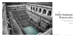
  • 1. Delhi Sultanate Waterworks Ancient network of water harvesting structures in Delhi, India. Tanvi Gupta Figure 1 Typical Baoli stepwell atmosphere. Delhi Sultanate Waterworks
  • 2. Y a m u n a Y a m u n a Najafgarh canal New Delhi Hauz Khas Chha�arpur IGI Airport Badarpur Dwarka Rohini Shalimar Bagh Shahdara Narela Bawana Mukandpur Palla Asola Northern Basin Southern Basin Western Basin Delhi is located in the Northern part of India between 28.7041 N latitudes and 77.1025 E longitude. It occupies an area of 1,484 sq. km. and is continuously inhabited since the 6th century BCE. Through most of its history Delhi has served as capital of various kingdoms, most notably the Delhi Sultanate and Maughal empire. Two prominent features of the geography of Delhi are the Yamuna floodplains and the Delhi ridge. The ridge is the northern extension of the ancient Aravalli range covering an area of about 35 km and reaching height of 318 m (1,043 ft), it is a dominant feature of the region. Figure 2 Country scale map Water-shed Yamuna Region of Delhi Southern basin, Catchment area Figure 3 City scale map: the traditional water system of the bund baoli and hauz start- ing from the Delhi sultanate is chosen for study. Context. Delhi Sultanate Waterworks
  • 3. Delhi’s urban waterworks developed in early thirteenth century. They took the following main forms of Hauz (water tank), baoli (stepwell) and bund (embankment). Collectively these small structures served the sultanate capitals of South Western Delhi. As with other ancient and medieval water systems, they were incremental and coordinated. Urban lakes, tanks and reservoirs were sited in gently sloping areas adjacent to hillside water control structures. Sultanate Waterworks. Figure 4 Historical photo of Satpulla embankment or bund. Figure 5 Historical photo of Baoli at Tughlaqabad. Figure 6 Historical photo of Hauz-i-khas lake (water tank). Figure 7 Historical photo of Sluice gate at Tughlaqabad. Delhi Sultanate Waterworks
  • 4. Jan Feb Mar Apr May Jun Jul Aug Sep Oct Nov Dec 0 19 19 15 20 25 70 237.5 235 112 18 10 10 5 10 15 20 25 30 35 40 45 t ( C) high t low t Climate. Figure 8 Temperature and precipitation graph. Figure 9 Evapotranspiration map Figure 10 Annual Precipitation map Delhi Sultanate Waterworks
  • 5. The contours of the physical landscape of Delhi as we see today, including its flora and fauna are very different from what they were thousands of years ago. The Delhi ridge as shown in the figure constitute the Northernmost extensions of the Aravalli hills, the oldest mountains in India formed hundreds of million years ago. They enter Delhi from the South-West running through the city in a North-east direction. Today the height of the rocky Delhi ridge ranges between 2.5 m to 90 m above floodplain in North and South Delhi, in ancient times it would have been much higher (S. Upinder, 2006). Most Sultanate cities and waterworks aligned themselves along this ridge to capture its runoff. The junction between the central and the Southern ridge became the preferred location for Sultanate urbanization and water control. Delhi sultanate waterworks developed during the early 13th century. They took three main forms - the bund network (embankment), hauz (water tank), and baoli (stepwell). These reflect the main strategies of the Delhi Sultanate water works - the bund network helps in directing and capturing the runoff from the ridge, the hauz stores the surplus monsoon surface water runoff and recharges ground water while the baolis tap into the shallow ground water along with storing rainwater. The bunds define a network of 25 water structures along 40 miles of the ridge as shown in the figure. They harnessed rain fed rivulets or sheet drainage along the slopes of Delhi ridge to create perennial reservoirs, for use in the dry winter months. Thus, the first bund sequence on either side of the ridge entrapped rain runoff and the second sequence controlled and channeled water to city reservoirs, defense moats and irrigation canals. This 40 mile network with over 15 rivulets and 60 miles of running water was in continuous use for over two centuries. Delhi’s Streams or Nallahs In the triangle created or the ridge, Delhi’s alluvial plain is watered by a number of seasonal or perennial nallahs (canals). These nallahs flow down the Aravalli hills (ridge) slope through eroded gullies into the Yamuna river. East flowing streams were tapped to feed large, lined lakes such as Anangtal, Hauz-i-Shamsi, Hauz-i-rani, and hauz- i-khas which sustained the cities of Anangpur, Mehrauli, Jahanpanah and Siri. Despite the presence of river Yamuna most of Delhi’s population depended on underground or stored water until the arrival of piped water supply in the late nineteenth century. Water tables recharged by nallahs allowed a number of baolis (large stepwells built with several levels). The quality of groundwater shows wide variations with depth, at most locations water quality deteriorates with depth. Canals and streams play an important role in sustaining fresh water aquifers in Delhi’s upper strata of water-bearing soil. Catchment Area. Figure 11 Bund network along Ridge. Delhi Sultanate Waterworks
  • 6. Tughlaqabad Fort Water system. During the period of Delhi Sultanate, new cities were founded at strategic locations where water was the most important factor in their siting - its collection, storage and distribution predominated the settlement pattern. Tughlaqabad fort was built by Ghiyas-ud-din Tughlaq, located on a hill surrounded by a basin. The fort was planned based on the contours of the site to form an irregular trapezium. The palace was quarried from the site itself and the quarries were subsequently used as moats and reservoirs. The surroundings of Tughlaqabad was transformed into a large lake with the help of waterworks (bunds) which collected water from the ridge. Tughlaqabad had 3 huge baolis and several wells for water supply as highlighted in the illustration. Creating a lake at the South of the Tughlaqabad fort was a challenge since the site was not close to river Yamuna and in order to bring the river water up to the hilltop where the fort was located, water had to be pumped up by means of a canal which was considered impractical. The lake was therefore dependent on local streams and monsoon floodwater which was channeled into a depression at the south of the town where the water was regulated by means of several dams and a sluice gate controlling the outlet which flowed into a canal. The dams are constructed as simple earth embankments lined on the lake side with blocks of stone. This stretch is around 200m long and runs between Adilabad and Tughlaqabad. Stepwells, water channels, embankments and canals. Figure 12 View of Southern end of retaining wall of the dam between Adila- bad and Tughlaqabad seen from lakeside showing steps leading to water. Figure 13 View of Tughlaqabad lake surrounding tomb of Ghiyas-ud-din Tugh- laq. Figure 14 Tughlaqabad town water system plan. Delhi Sultanate Waterworks
  • 7. A main water feature in the Tughlaqabad fort is a deep stepped reservoir (baoli). The baoli is roughly rectangular about 20 x 18 m. Towards the east side we see the remains of the steps which gave access to the water, the baoli is approximately over 16m deep. Towards the North we see the stone brackets for wheel or pulley are preserved, extending over the water. This apparatus was used for withdrawing large quantities of water for irrigation and it is likely that this baoli was a major source of water for farmlands, while drinking water was provided elsewhere. It was a usual practice during this period to construct forts on rocky hillsides to excavate wells down to the water table to ensure permanent supply of potable water. Stepwells, water channels and embankments. Tughlaqabad Fort Baoli. Figure 15 Baoli typology analysis and details. Key plan (above). Delhi Sultanate Waterworks
  • 8. Another example of the ingenious water structure is the sluice gate, controlling the level of water in the lake water south of the town of Tughlaqabad. The water work was a simple device which could be operated by an unskilled person - an uncomplicated structure with a sophisticated design. The structure opens to a canal with stone lined walls which runs between the dam and the outer fortification walls of Adilabad. The canal was further divided into two branches, one taking the water to the irrigated fields and the other leading to moat around town wall. The sluice gate itself consists of three arches, each containing twelve small sluices at four levels, three sluices at each level. The western side of the arch facing the lake is walled up with massive stones and the inlet of the sluices are small rectangular canals, which appear as small apertures on lake side. Inside the arches, the four levels of sluices are stacked in a step form with eight steps. The lower step is for standing on and the upper one has the slots. Each slot measured 35x10 cm wide and 75 cm deep to house wooden shutters which controlled the flow of water. Access to these steps is provided via two sets of stairs built into the piers at either end of the structure. Tughlaqabad Fort bund. Stepwells, water channels and embankments. Figure 16 The sluice gate and Dam south of Tughlaqabad. Figure 17 Sluice gate site plan. Figure 18 Sluice gate plan. Figure 19 Sluice gate plan at roof level. Figure 20 Sluice gate view from lake looking Eastwards. Figure 21 Sluice gate elevation lake side looking eastwards. Delhi Sultanate Waterworks
  • 9. Functioning The operation of the sluice gate was simple and could be carried out by a single person, who first went down to the lowest level to insert small shutters into slots of the lowest nine canals. The water of the lake would then rise up to the next level and the same process would be repeated at this level. In the case of heavy monsoon, a single person would remove the shutter of the upper level and excess water would gush out as small waterfall through the arches into the canal. The site of the lake is now used for cultivation. The design concept of this sluice gate, to retain and control the water of a relatively large lake by a very simple method and no use of power was a great achievement of its time. Figure 22 Sluice gate elevation dam side looking westwards Figure 23 Sluice gate plan Figure 24 Detail plan of central slots Figure 25 Section AA through central arch showing four levels of sluices and highest water level Figure 26 Perspective section showing sluice functioning Figure 27 Showing function of sluice with help of wooden shutter Figure 28 Wooden shutter detail Delhi Sultanate Waterworks
  • 10. Circularity. Delhi Sultanate waterworks or harvesting structures were well coordinated with one another, each structure supporting the existence of the other. The bunds helped in controlling the rainwater runoff from the ridge which was further directed to feed large lakes or royal tanks called hauz. The baoli were recharged by the rainwater and helped in tapping the inaccessible ground water with the help of steps. These water storage structures aided water evaporation and condensation into the atmosphere which again would be captured in the ridge landscape during monsoon. Today, these water structures lie in a dilapidated state with some having been restored for heritage and tourism purposes. Thus, it is important to learn from past methods of harvesting water to overcome the hydrological problems Delhi is facing today, despite having a combination of river and ridge landscape as part of its natural terrain. Circularity Delhi Sutanate waterworks or harvesting structures were well coordinated with one another, each structure supporting the existence of the other. The bunds helped in controlling the rainwater runoff from the ridge which was further directed to feed large lakes or royal tanks called hauz. The baoli were recharged by the rainwater and helped in tapping the inaccessible ground water with the help of steps. These water storage structures aided water evaporation and condensation into the atmosphere which again would be captured in the ridge landscape during monsoon. would be captured in the ridge landscape during monsoon. Today, these water structures lie in a dilapidated state with some having been restored for heritage and tourism purposes. Thus, it is important to learn from past methods of harvesting water to overcome the hydrological problems Delhi is facing today, despite having a combination of river and ridge landscape as part of its natural terrain. Figure Circularity of the system Figure 29 Circularity of the system. Delhi Sultanate Waterworks
  • 11. Strategic values - During this period Delhi’s terrain was used smartly to gain maximum profit with the minimum resources by taking advantage of Delhi’s hilly ridge landscape where most of the waterworks were situated. This landscape provided all resources like maximum rain, groundwater in order to harvest water efficiently without using any source of energy or power. Values of Sustainability - The project shows the sustainability of the water system, the natural and human resources have been carefully used such as taking advantage of the natural flow of water from higher terrain to lower. This water captured was used for both the purpose of meeting the drinking water needs of Delhi and also the irrigation needs for agriculture. These also served the purpose of rainwater storage or rainwater harvesting. Most of the elements performed more than double the function. Ethnographic and Identity values - The Sultanate period is known for its famous tank system (hauz), another very important structure of water management the period is known for its the network of stepwells or baolis. Most of Sultanate waterworks were of secular character whereby anyone could draw water from them and were mainly used for common people’s water needs and requirements. Landscape values - Water played an important role in the location of most of Sultanate cities and settlements. This whole system of tank, baolis and wells manages water supply to whole complex of settlements during medieval history period of Delhi. Moreover, the system was planned to function as a decentralized runoff harvesting such that silting of a tank at one location did not affect the others. The homogeneity of the system avoided all post-harvesting social problems of water management that are involved in water management. The purpose of this research is to study the ancient or medieval water management system during the period of Sultanate Delhi and their understanding of the region’s terrain to harvest water through various water work structures. The study focuses on the urban water management of Sultanate Delhi, where most of the cities were located on Delhi’s hilly ridge terrain from where rain water was controlled and channelized. Being in a humid sub tropical and semi arid zone, the frequency of water shortages and droughts is high. However ‘Ancient civilizations grasped the complex reciprocities of natural systems and created an infrastructure that was modeled on, and worked in tandem with those reciprocities’ (Brown and Stigge, 2017). The Delhi watershed comprised of ridge,river and plains, its constellation of channels, canals, bridges and tanks served all important for conserving the city. Delhi Sultanate waterworks influenced subsequent eras of urban development and conservation. The historical water works of Sultanate Delhi have urban- scale significance. With efforts to recover the dying wisdom of traditional water harvesting systems which have expanding meaning and utility. Many of these urban historical waterworks are at a risk of further deterioration along with the degraded canals of the city. However, their imposing architecture continue to persist in the city’s landscape. Architectural values - The structural elements and materials used in the system came from the knowledge of traditional or vernacular construction techniques which adapt to the climate and lithology of the region. The smaller bunds or embankments were constructed of Earth, however large dams were built of rubble masonry or wood which were easily available local materials. Conclusion. Lessons to learn - The study shows that Delhi was not always short of water. It was ensured that Delhi had enough water from its wells, baolis, water tanks, canals, ridge and the Yamuna. The ancient rulers of Delhi had an intricately worked out water conservation and distribution system along the Southern ridge ,the tail end of the Aravalli hills. They realized the importance of water security and made an elaborate system of bunds across gullies to capture water off this rocky landscape. In present times, these water structures lie in a dilapidated state, some have been restored to their past glory but only for heritage purposes. Most of these sites have been taken over by the powerful and the rich to make their houses and other urban infrastructure, decimating the cities water resources. Today, most of the water needs of the citizens of Delhi are met by exploiting its ground water resource by continuous extraction of ground water through private tube-wells. If these dilapidated water structures of Delhi are restored and protected they can still contribute to some of the city’s water requirements. Thus, it is important to learn how Delhi’s historical rulers made use of its terrain of ridge and river landscape to ensure supply of water to its citizens without exploiting and wasting its resources. Figure 30 Conserved baoli in Delhi, India Delhi Sultanate Waterworks
  • 12. Project 5 - Delhi Sultanate Waterworks M. Shokoohy, N. Shokoohy, 2003 Tughluqabad, third interim report: gates, silos, waterworks and other features. Bulletin of the School of Oriental and Afri- can Studies, 66, pp 14-55 doi:10.1017/S0041977X03000028 N. Jacob, 2008 Jalyatra: Exploring Indias Traditional Water Management systems Retrieved from: http://www.jalyatra. com/chapters/delhi_final.pdf Delhi urban Art Commission, 2018 Water and Heriatage: Rejuvenation of Baoli Precints Retrieved from: https://www. duac.org/site_content/attachments/Water%20and%20Heri- tage.pdf D. Cherian, 2004 Pairing mega events and hydrological sys- tems for urban sustainability: Strategy franework for Delhi beyond the Commonwealth Games 2010. Retreived from: https://dspace.mit.edu/handle/1721.1/28802 A. Sharma, M. Kumar, M. Singh, H. Mazhari 2019 Me- dieval (Islamic) Cities in India: An Environmental Re- view and its Contemporary Relevance https://doi. org/10.1177/0376983619856166 Illustration Credits Figure 1 [Image] Retrieved from https://www. indiawaterportal.org/articles/sun-stone-and-water-rajon-ki- baoli-mehrauli Figure 2 Country scale map [Figure]. Drawn by author Figure 3 City scale map [Figure]. Drawn by author Figure 4 [image] Retrieved from https://www.jstor.org/ stable/44148473 DOI: 10.2307/44148473 Figure 5 [Image] Retrieved from https:// commons.m.wikimedia.org/wiki/File:Tuglagbad_Baoli_1.jpg Figure 6 [Image] https://en.m.wikipedia.org/wiki/File:Hauz_ Khas_Lake.jpg Figure 7 [Image] Retrieved from https://susycogamipybix. hotseattleseahawksjerseys.com/tughluqabad-book- 35070zv.php Figure 8 Temperature and precipitation graph [Figure]. Drawn by Author Figure 9 Evapotranspiration map [Figure]. Drawn by Author Figure 10 Annual Precipitation map [Figure]. Drawn by Author Figure 11 Bund Network along Ridge [Figure]. Drawn by author. Retrieved from https://dspace.mit.edu/ handle/1721.1/28802 Figure 12 [Image] Retrieved from https://susycogamipybix. hotseattleseahawksjerseys.com/tughluqabad-book- 35070zv.php Figure 13 [Image] Retrieved from https://susycogamipybix. hotseattleseahawksjerseys.com/tughluqabad-book- 35070zv.php Figure 14 Tughlaqabad town watersystem plan [Figure] Retrieved from https://susycogamipybix. hotseattleseahawksjerseys.com/tughluqabad-book- 35070zv.php. Drawn by Author Figure 15 Baoli typology analysis and details [Figure] Retrieved from https://susycogamipybix. hotseattleseahawksjerseys.com/tughluqabad-book- 35070zv.php. Drawn by Author Figure 22 Sluice gate elevation dam side looking westwards. [Image] Retrieved from https://susycogamipybix.hotseattle- seahawksjerseys.com/tughluqabad-book-35070zv.php Figure 23 Sluice gate plan [Figure] Retrieved from https:// susycogamipybix.hotseattleseahawksjerseys.com/tughluqa- bad-book-35070zv.php. Drawn by Author Figure 24 Detail plan of central slots [Figure] Retrieved from https://susycogamipybix.hotseattleseahawksjerseys.com/ tughluqabad-book-35070zv.php. Drawn by Author Figure 25 Section AA through central arch showing four lev- els of sluices and highest water level [Figure] Retrieved from https://susycogamipybix.hotseattleseahawksjerseys.com/ tughluqabad-book-35070zv.php. Drawn by Author Figure 26 Perspective section showing sluice functioning [Figure] Retrieved from https://susycogamipybix.hotseat- tleseahawksjerseys.com/tughluqabad-book-35070zv.php. Drawn by Author Figure 27 Showing function of sluice with help of wooden shutter [Figure] Retrieved from https://susycogamipybix.ho- tseattleseahawksjerseys.com/tughluqabad-book-35070zv. php. Drawn by Author Figure 28 Wooden shutter detail [Figure] Retrieved from https://susycogamipybix.hotseattleseahawksjerseys.com/ tughluqabad-book-35070zv.php. Drawn by Author Figure 29 Circularity of the system [Figure] Drawn by Author Figure 30 Conserved baoli in Delhi, India [Image] Retrieved from https://archnet.org/sites/6400 References. Delhi Sultanate Waterworks