SlideShare a Scribd company logo
1 of 2
The precinct consisted of
                                                                                                                     land held both by freehold
                                                                                                                     and under a certain lease
                                                                                                                     scheme called ‘Nazul Niti’,
                                                                                                                     which meant that the land
                                                                                                                     was originally ‘given away’
                                                                                                                     to certain loyal officers at
                                                                                                                     the time of the British
                                                                                                                     Imperial rule, but turned
                                                                                                                     into Government Lease
                                                                                                                     after Independence. More
                                                                                                                     than 50% of the properties
                                                                                                                     were on Nazul Land. The                       Existing Land Titling Data
                                                                                                                     precinct was an important
                                                                                                                     market of the city, and like
                                                                                                                     most traditional Indian
                                                                                                                     settlements, it had a mixed
                                                                                                                     use character with typically
                                                                                                                     commercial use at the
                                                                                                                     ground floor and residential
                                                                                                                     at the upper floors. The
                                                                                                                     dense urban fabric (as
                                                                                                                     shown in the 3D images) of
                                                                                                                     the precinct was the root of
                                                                                                                     most problems within the
                                                                                                                     area and had repercussions
                                                                                                                     across the city.                               Existing Built Use Data
  Proposed Plot Grouping
Dehradun City Centre, popularly known as the Ghantaghar area holds a           Though most of these roads have inadequate widths in the central area,
significant identity due to its location, character and activities since the   Chakrata road specifically has been a major bottleneck for traffic
growth of the town. Earlier known to be part of the military cantonment,       movement.
the area is now a bustling commercial hub. The city centre is linked           This redevelopment project is an attempt to improve and refurbish the
directly to the major growth centres within and outside Dehradun. Its          Chakrata road and its adjoining area. The project will have multi-fold
recent status of a capital city has added new dimensions of development        advantages. Apart from opening the bottlenecks along the Chakrata road,
to the entire city as well as this central area.                               it will provide opportunity to maximise the economic potential of
Over the years, there has been an increasing problem of traffic                properties, rehabilitate substandard buildings, improve parking,
congestion, haphazard parking and irregular traffic movement around            beautify streetscape and promote new development.
the Ghantahar area. The city level radial roads converge in this central       The project will also help to develop the Nazul land around GPO
area leading to concentration of through and the locally generated             (General Post Office) and resolve the tenure issues in a mutually
traffic.                                                                       beneficial manner. This project will be a unique step in developing a well
                                                                               planned and vibrant city centre.

C I T Y C E N T R E R E D E V E LO P M E N T p l a n
CHAKRATA ROAD, mussoorie dehradun development authority                                                                                                      View of Central Clock Tower


                                                                                                Documentation & Analysis
  S u d h i r Vo h ra C o n s u l t a n t s                                                                                                         professional     academic       personal
Existing Section through Chakrata Road


                                                                                                                                         Proposed Chakrata Road Section with G+3 Floors


 Proposed Plot Reconstitution
      The participatory approach of Land Pooling would be adopted over the traditional Land
Acquisition method. In this process the land will be under a provisional take over by the govt.
for a fixed period of time and shall be given back to the stakeholders in the form of well de-
fined, buildable plots after providing for open spaces and access roads. Each pocket has a
number of properties, with multiple owners. Therefore it was proposed that each pocket will
form a co-operative with all owners/ occupants within that pocket being shareholders. The
shareholding pattern will be based on valuation of each building/ property.Various options
were evaluated on the basis of size of plot, practicable setbacks, primary and internal access,
to arrive at the option selected (shown on previous page). These pockets are distinct and have     The proposal involved generation of a practicable plot
been defined on the basis of location/ geographic proximity, building use and judgment of          reconstitution scheme, effective street design that
build able plot size and present land status.                                                      incorporates parking as well as pedestrian movement and
It was seen that 20% deduction in original plot area is sufficient to provide for roads and open   formulation of minimalistic yet cohesive design controls.
spaces. At present, the existing FSI for the entire project area is 1.38. The development con-     The elevational controls were also designed keeping in
trol regulations permit a FSI of 2.0 here which shows underutilization. The solution required      mind the modest resources that the people of the
an optimal balance between permitted FSI, Building Height, Ground Coverage, and                    community could afford, while maintaining the quaint
         the resulting IRR (Internal Rate of Return) for such an occupant led development.         character of a hill station.

C I T Y C E N T R E R E D E V E LO P M E N T p l a n                                                                                                           Proposed Elevation Controls
CHAKRATA ROAD, mussoorie dehradun development authority
                                                                                                                                Design Proposal
  S u d h i r Vo h ra C o n s u l t a n t s                                                                                                 professional       academic        personal

More Related Content

Viewers also liked

Feasibility of Straddling Bus – Smart Transportation Technology for a city of...
Feasibility of Straddling Bus – Smart Transportation Technology for a city of...Feasibility of Straddling Bus – Smart Transportation Technology for a city of...
Feasibility of Straddling Bus – Smart Transportation Technology for a city of...Sundar Surya Ganesh Gonella
 
Case Study (Stockholm City)
Case Study (Stockholm City)Case Study (Stockholm City)
Case Study (Stockholm City)suzilawatie
 
Master plan and land use
Master plan and land useMaster plan and land use
Master plan and land useShourya Puri
 
What's different between urban planning, urban design, architecture, AADI
What's different between urban planning, urban design, architecture, AADIWhat's different between urban planning, urban design, architecture, AADI
What's different between urban planning, urban design, architecture, AADIaalliance
 
Master plan (Town Planning)
Master plan (Town Planning)Master plan (Town Planning)
Master plan (Town Planning)S.m. Atik
 
Urban design analysis, Circulation, Architecture, London, Redevelopment studies
Urban design analysis, Circulation, Architecture, London, Redevelopment  studiesUrban design analysis, Circulation, Architecture, London, Redevelopment  studies
Urban design analysis, Circulation, Architecture, London, Redevelopment studiesSujeet Thakare
 

Viewers also liked (18)

Feasibility of Straddling Bus – Smart Transportation Technology for a city of...
Feasibility of Straddling Bus – Smart Transportation Technology for a city of...Feasibility of Straddling Bus – Smart Transportation Technology for a city of...
Feasibility of Straddling Bus – Smart Transportation Technology for a city of...
 
Development Plan -Planning Interventions by School of Planning and Architectu...
Development Plan -Planning Interventions by School of Planning and Architectu...Development Plan -Planning Interventions by School of Planning and Architectu...
Development Plan -Planning Interventions by School of Planning and Architectu...
 
Development Plan- Planning Intervention By SVNIT Surat.
Development Plan- Planning Intervention By SVNIT Surat.Development Plan- Planning Intervention By SVNIT Surat.
Development Plan- Planning Intervention By SVNIT Surat.
 
INDORE
INDORE INDORE
INDORE
 
Development Plan
Development PlanDevelopment Plan
Development Plan
 
Selaqui school
Selaqui schoolSelaqui school
Selaqui school
 
Case Study (Stockholm City)
Case Study (Stockholm City)Case Study (Stockholm City)
Case Study (Stockholm City)
 
Development Plan- Planning Intervention (CRITICAL ANALYSIS OF MASTER PLAN CA...
Development Plan- Planning Intervention (CRITICAL ANALYSIS OF MASTER PLAN  CA...Development Plan- Planning Intervention (CRITICAL ANALYSIS OF MASTER PLAN  CA...
Development Plan- Planning Intervention (CRITICAL ANALYSIS OF MASTER PLAN CA...
 
Smart Cities
Smart CitiesSmart Cities
Smart Cities
 
Master plan and land use
Master plan and land useMaster plan and land use
Master plan and land use
 
Uttrakhand ppt
Uttrakhand pptUttrakhand ppt
Uttrakhand ppt
 
What's different between urban planning, urban design, architecture, AADI
What's different between urban planning, urban design, architecture, AADIWhat's different between urban planning, urban design, architecture, AADI
What's different between urban planning, urban design, architecture, AADI
 
Master plan (Town Planning)
Master plan (Town Planning)Master plan (Town Planning)
Master plan (Town Planning)
 
urban design project 3
urban design project 3urban design project 3
urban design project 3
 
Urban Design Definition
Urban Design DefinitionUrban Design Definition
Urban Design Definition
 
Urban Design project 1
Urban Design project 1Urban Design project 1
Urban Design project 1
 
Urban design analysis, Circulation, Architecture, London, Redevelopment studies
Urban design analysis, Circulation, Architecture, London, Redevelopment  studiesUrban design analysis, Circulation, Architecture, London, Redevelopment  studies
Urban design analysis, Circulation, Architecture, London, Redevelopment studies
 
Himalaya project presentation
Himalaya project presentationHimalaya project presentation
Himalaya project presentation
 

Dehradun Redevelopment

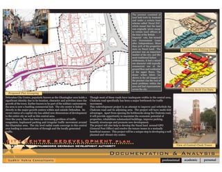
  • 1. The precinct consisted of land held both by freehold and under a certain lease scheme called ‘Nazul Niti’, which meant that the land was originally ‘given away’ to certain loyal officers at the time of the British Imperial rule, but turned into Government Lease after Independence. More than 50% of the properties were on Nazul Land. The Existing Land Titling Data precinct was an important market of the city, and like most traditional Indian settlements, it had a mixed use character with typically commercial use at the ground floor and residential at the upper floors. The dense urban fabric (as shown in the 3D images) of the precinct was the root of most problems within the area and had repercussions across the city. Existing Built Use Data Proposed Plot Grouping Dehradun City Centre, popularly known as the Ghantaghar area holds a Though most of these roads have inadequate widths in the central area, significant identity due to its location, character and activities since the Chakrata road specifically has been a major bottleneck for traffic growth of the town. Earlier known to be part of the military cantonment, movement. the area is now a bustling commercial hub. The city centre is linked This redevelopment project is an attempt to improve and refurbish the directly to the major growth centres within and outside Dehradun. Its Chakrata road and its adjoining area. The project will have multi-fold recent status of a capital city has added new dimensions of development advantages. Apart from opening the bottlenecks along the Chakrata road, to the entire city as well as this central area. it will provide opportunity to maximise the economic potential of Over the years, there has been an increasing problem of traffic properties, rehabilitate substandard buildings, improve parking, congestion, haphazard parking and irregular traffic movement around beautify streetscape and promote new development. the Ghantahar area. The city level radial roads converge in this central The project will also help to develop the Nazul land around GPO area leading to concentration of through and the locally generated (General Post Office) and resolve the tenure issues in a mutually traffic. beneficial manner. This project will be a unique step in developing a well planned and vibrant city centre. C I T Y C E N T R E R E D E V E LO P M E N T p l a n CHAKRATA ROAD, mussoorie dehradun development authority View of Central Clock Tower Documentation & Analysis S u d h i r Vo h ra C o n s u l t a n t s professional academic personal
  • 2. Existing Section through Chakrata Road Proposed Chakrata Road Section with G+3 Floors Proposed Plot Reconstitution The participatory approach of Land Pooling would be adopted over the traditional Land Acquisition method. In this process the land will be under a provisional take over by the govt. for a fixed period of time and shall be given back to the stakeholders in the form of well de- fined, buildable plots after providing for open spaces and access roads. Each pocket has a number of properties, with multiple owners. Therefore it was proposed that each pocket will form a co-operative with all owners/ occupants within that pocket being shareholders. The shareholding pattern will be based on valuation of each building/ property.Various options were evaluated on the basis of size of plot, practicable setbacks, primary and internal access, to arrive at the option selected (shown on previous page). These pockets are distinct and have The proposal involved generation of a practicable plot been defined on the basis of location/ geographic proximity, building use and judgment of reconstitution scheme, effective street design that build able plot size and present land status. incorporates parking as well as pedestrian movement and It was seen that 20% deduction in original plot area is sufficient to provide for roads and open formulation of minimalistic yet cohesive design controls. spaces. At present, the existing FSI for the entire project area is 1.38. The development con- The elevational controls were also designed keeping in trol regulations permit a FSI of 2.0 here which shows underutilization. The solution required mind the modest resources that the people of the an optimal balance between permitted FSI, Building Height, Ground Coverage, and community could afford, while maintaining the quaint the resulting IRR (Internal Rate of Return) for such an occupant led development. character of a hill station. C I T Y C E N T R E R E D E V E LO P M E N T p l a n Proposed Elevation Controls CHAKRATA ROAD, mussoorie dehradun development authority Design Proposal S u d h i r Vo h ra C o n s u l t a n t s professional academic personal